| Locality | Latitude | Longitude | Distance | Bearing |
|---|
| White Pine Mine, White Pine, Ontonagon County, Michigan, USA | 46° 45' 0" N | 89° 32' 59" W | 0.0km (0.0 miles) | |
| Copper Harbor Conglomerate, White Pine Mine, White Pine, Ontonagon County, Michigan, USA | 46° 45' 0" N | 89° 32' 58" W | 0.0km (0.0 miles) | |
| Nonesuch formation, White Pine, Ontonagon County, Michigan, USA | 46° 45' 3" N | 89° 34' 45" W | 2.2km (1.4 miles) | |
| White Pine, Ontonagon County, Michigan, USA | 46° 45' 10" N | 89° 35' 0" W | 2.6km (1.6 miles) | |
| Boston & North American Silver prospect, Silver City, Ontonagon County, Michigan, USA | 46° 47' 3" N | 89° 35' 9" W | 4.7km (2.9 miles) | |
| Cleveland Silver Prospect, Ontonagon County, Michigan, USA | 46° 47' 21" N | 89° 34' 19" W | 4.7km (2.9 miles) | |
| Collins Mine, Ontonagon County, Michigan, USA | 46° 47' 35" N | 89° 34' 30" W | 5.2km (3.2 miles) | |
| Nonesuch Mine, White Pine, Ontonagon County, Michigan, USA | 46° 45' 15" N | 89° 37' 6" W | 5.3km (3.3 miles) | |
| Cleveland Mine, Ontonagon County, Michigan, USA | 46° 47' 44" N | 89° 34' 23" W | 5.4km (3.3 miles) | |
| Superior Silver Mine (Collins Silver), Silver City, Ontonagon County, Michigan, USA | 46° 48' 16" N | 89° 34' 26" W | 6.4km (3.9 miles) | |
| Ontonagon Silver Mine, Silver City, Ontonagon County, Michigan, USA | 46° 48' 29" N | 89° 34' 6" W | 6.6km (4.1 miles) | |
| Onondaga Exploration, Ontonagon County, Michigan, USA | 46° 41' 26" N | 89° 34' 36" W | 6.9km (4.3 miles) | |
| Halliwell Mine, Porcupine Mountains, Ontonagon County, Michigan, USA | 46° 47' 18" N | 89° 37' 23" W | 7.0km (4.4 miles) | |
| Union Mine (Bell No. 2 Mine), Porcupine Mountains, Ontonagon County, Michigan, USA | 46° 47' 44" N | 89° 37' 27" W | 7.6km (4.7 miles) | |
| Scranton Mine, Silver City, Ontonagon County, Michigan, USA | 46° 48' 51" N | 89° 35' 4" W | 7.6km (4.7 miles) | |
| Beaser Silver prospect, Silver City, Ontonagon County, Michigan, USA | 46° 49' 9" N | 89° 34' 9" W | 7.9km (4.9 miles) | |
| Howes White Pine Quarry, Ontonagon County, Michigan, USA | 46° 43' 0" N | 89° 27' 30" W | 7.9km (4.9 miles) | |
| Little Iron River, Silver City, Ontonagon County, Michigan, USA | 46° 49' 0" N | 89° 35' 8" W | 7.9km (4.9 miles) | |
| Mammoth Silver prospect, Silver City, Ontonagon County, Michigan, USA | 46° 49' 9" N | 89° 34' 45" W | 8.0km (5.0 miles) | |
| Silver City, Ontonagon County, Michigan, USA | 46° 49' 47" N | 89° 34' 21" W | 9.1km (5.6 miles) | |
| Gull Point, Ontonagon County, Michigan, USA | 46° 50' 15" N | 89° 33' 0" W | 9.7km (6.0 miles) | |
| George Hocking Construction Company Quarry, Ontonagon County, Michigan, USA | 46° 42' 57" N | 89° 25' 16" W | 10.5km (6.5 miles) | |
| White Pine Extension Mine (Pinex Mine), White Pine, Ontonagon County, Michigan, USA | 46° 44' 37" N | 89° 43' 27" W | 13.3km (8.3 miles) | |
| Cascade prospect, Matchwood Township, Ontonagon County, Michigan, USA | 46° 39' 14" N | 89° 26' 40" W | 13.4km (8.3 miles) | |
| Cranberry Creek, Ontonagon County, Michigan, USA | 46° 49' 50" N | 89° 25' 0" W | 13.5km (8.4 miles) | |
| Cuyahoga Mine, Porcupine Mountains, Ontonagon County, Michigan, USA | 46° 48' 57" N | 89° 41' 57" W | 13.5km (8.4 miles) | |
| Sharon Mine, Norwich, Ontonagon County, Michigan, USA | 46° 39' 12" N | 89° 26' 17" W | 13.7km (8.5 miles) | |
| Cunningham Creek, Ontonagon County, Michigan, USA | 46° 45' 12" N | 89° 22' 13" W | 13.7km (8.5 miles) | |
| Eureka Mine (Merryweather; Conklin), Ontonagon County, Michigan, USA | 46° 40' 23" N | 89° 24' 18" W | 14.0km (8.7 miles) | |
| Waukulla Mine, Bergland, Ontonagon County, Michigan, USA | 46° 38' 11" N | 89° 28' 10" W | 14.0km (8.7 miles) | |
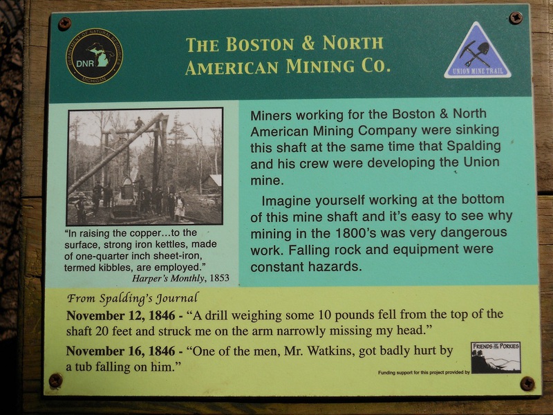


Boston & North American Silver prospect, Silver City, Ontonagon County, Michigan, USA