| Locality | Latitude | Longitude | Distance | Bearing |
|---|
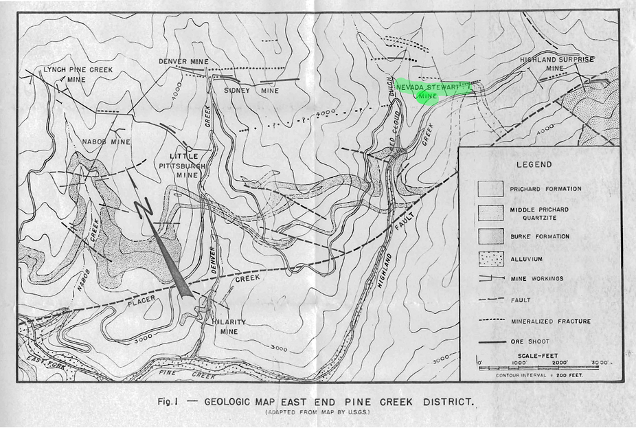
| Sidney Mine, Pine Creek Mining District, Shoshone County, Idaho, USA | 47° 29' 18" N | 116° 11' 32" W | 0.0km (0.0 miles) | |
| Denver Mine, Pine Creek Mining District, Shoshone County, Idaho, USA | 47° 29' 26" N | 116° 11' 31" W | 0.3km (0.2 miles) | |
| Yankee Girl Mine (Perhaps; Sunshine Consolidated Mine), Yreka, Shoshone County, Idaho, USA | 47° 29' 17" N | 116° 11' 49" W | 0.4km (0.2 miles) | |
| Little Pittsburg Mine, Pine Creek Mining District, Shoshone County, Idaho, USA | 47° 29' 4" N | 116° 11' 59" W | 0.7km (0.4 miles) | |
| Linda-Bowden Lodes, Pine Creek Mining District, Shoshone County, Idaho, USA | 47° 29' 7" N | 116° 10' 59" W | 0.8km (0.5 miles) | |
| Cougar Mine, Pine Creek Mining District, Shoshone County, Idaho, USA | 47° 28' 53" N | 116° 11' 54" W | 0.9km (0.6 miles) | |
| Lynch Pine Creek Mine No.2, Pine Creek Mining District, Shoshone County, Idaho, USA | 47° 29' 31" N | 116° 12' 28" W | 1.2km (0.8 miles) | |
| V and Idaho Claim, Pine Creek Mining District, Shoshone County, Idaho, USA | 47° 29' 29" N | 116° 12' 32" W | 1.3km (0.8 miles) | |
| Nabob Mine, Pine Creek Mining District, Shoshone County, Idaho, USA | 47° 29' 7" N | 116° 12' 33" W | 1.3km (0.8 miles) | |
| Idaho prospect, Pine Creek Mining District, Shoshone County, Idaho, USA | 47° 29' 42" N | 116° 12' 35" W | 1.5km (1.0 miles) | |
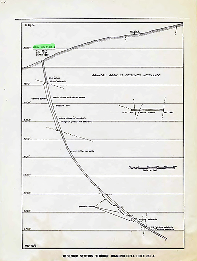
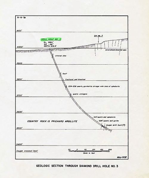
| Nevada Stewart Mine, Pine Creek Mining District, Shoshone County, Idaho, USA | 47° 28' 50" N | 116° 10' 16" W | 1.8km (1.1 miles) | |
| Hilarity Silver and Lead Mine, Pine Creek Mining District, Shoshone County, Idaho, USA | 47° 28' 22" N | 116° 12' 11" W | 1.9km (1.2 miles) | |
| Stewart Mine, Pine Creek Mining District, Shoshone County, Idaho, USA | 47° 28' 40" N | 116° 10' 11" W | 2.1km (1.3 miles) | |
| Star Antimony Group Mine, Pine Creek Mining District, Shoshone County, Idaho, USA | 47° 28' 10" N | 116° 11' 16" W | 2.1km (1.3 miles) | |
| Shetland Mining Company prospect, Pine Creek Mining District, Shoshone County, Idaho, USA | 47° 29' 45" N | 116° 13' 9" W | 2.2km (1.4 miles) | |
| Manila Adit, Pine Creek Mining District, Shoshone County, Idaho, USA | 47° 28' 36" N | 116° 10' 1" W | 2.3km (1.4 miles) | |
| Highland Surprise Mine, Pine Creek Mining District, Shoshone County, Idaho, USA | 47° 28' 45" N | 116° 9' 51" W | 2.3km (1.4 miles) | |
| Great Helena, Pine Creek Mining District, Shoshone County, Idaho, USA | 47° 29' 41" N | 116° 13' 18" W | 2.3km (1.4 miles) | |
| Little Pine Creek prospect, Shoshone County, Idaho, USA | 47° 30' 28" N | 116° 12' 14" W | 2.3km (1.5 miles) | |
| Surprise Mine, Pine Creek Mining District, Shoshone County, Idaho, USA | 47° 28' 47" N | 116° 9' 44" W | 2.4km (1.5 miles) | |
| Clara, Pine Creek Mining District, Shoshone County, Idaho, USA | 47° 28' 0" N | 116° 11' 53" W | 2.4km (1.5 miles) | |
| Lang Mine, Pine Creek Mining District, Shoshone County, Idaho, USA | 47° 27' 56" N | 116° 11' 43" W | 2.5km (1.6 miles) | |
| Big It Mine, Pine Creek Mining District, Shoshone County, Idaho, USA | 47° 28' 12" N | 116° 13' 5" W | 2.8km (1.7 miles) | |
| SF Fraction, Pine Creek Mining District, Shoshone County, Idaho, USA | 47° 27' 46" N | 116° 11' 49" W | 2.9km (1.8 miles) | |
| Silver prospects and adits, Pine Creek Mining District, Shoshone County, Idaho, USA | 47° 29' 48" N | 116° 13' 41" W | 2.9km (1.8 miles) | |
| Stunenberg, Pine Creek Mining District, Shoshone County, Idaho, USA | 47° 28' 40" N | 116° 9' 26" W | 2.9km (1.8 miles) | |
| Center Star, Pine Creek Mining District, Shoshone County, Idaho, USA | 47° 29' 59" N | 116° 13' 37" W | 2.9km (1.8 miles) | |
| Lookout Mountain Mine, Pine Creek Mining District, Shoshone County, Idaho, USA | 47° 29' 30" N | 116° 13' 58" W | 3.1km (1.9 miles) | |
| Blue Eagle prospect, Pine Creek Mining District, Shoshone County, Idaho, USA | 47° 27' 50" N | 116° 9' 52" W | 3.4km (2.1 miles) | |
| McKinely Extensions, Pine Creek Mining District, Shoshone County, Idaho, USA | 47° 29' 43" N | 116° 14' 18" W | 3.6km (2.2 miles) | |


Nevada Stewart Mine, Pine Creek Mining District, Shoshone County, Idaho, USA