| Locality | Latitude | Longitude | Distance | Bearing |
|---|
| Tolvadden Mine, Marazion, Cornwall, England, UK | 50° 7' 21" N | 5° 27' 15" W | 0.0km (0.0 miles) | |
| Wheal Jewell, Marazion, Cornwall, England, UK | 50° 7' 24" N | 5° 27' 6" W | 0.2km (0.1 miles) | |
| Trenow Consols, Charlotte United Mines, Perranuthnoe, Cornwall, England, UK | 50° 6' 55" N | 5° 27' 4" W | 0.8km (0.5 miles) | |
| Tregurtha Downs Mine, St Hilary, Cornwall, England, UK | 50° 7' 41" N | 5° 26' 47" W | 0.8km (0.5 miles) | |
| Perran Silver Mine, Perranuthnoe, Cornwall, England, UK | 50° 7' 0" N | 5° 26' 41" W | 0.9km (0.6 miles) | |
| Wheal Rodney (East Wheal Rodney), Tregurtha Downs Mine, St Hilary, Cornwall, England, UK | 50° 7' 50" N | 5° 27' 20" W | 0.9km (0.6 miles) | |
| Wheal Neptune, Perranuthnoe, Cornwall, England, UK | 50° 7' 5" N | 5° 26' 35" W | 0.9km (0.6 miles) | |
| Wheal Caroline, Goldsithney, Perranuthnoe, Cornwall, England, UK | 50° 7' 22" N | 5° 26' 26" W | 1.0km (0.6 miles) | |
| Gwallon Mine, St Hilary, Cornwall, England, UK | 50° 7' 59" N | 5° 27' 34" W | 1.2km (0.8 miles) | |
| Owen Vean Mine, Tregurtha Downs Mine, St Hilary, Cornwall, England, UK | 50° 7' 37" N | 5° 26' 17" W | 1.3km (0.8 miles) | |
| Goldsithney, Perranuthnoe, Cornwall, England, UK | 50° 7' 29" N | 5° 26' 12" W | 1.3km (0.8 miles) | |
| Wheal Prosper, St Hilary, Cornwall, England, UK | 50° 8' 3" N | 5° 27' 4" W | 1.3km (0.8 miles) | |
| The Greeb, Perranuthnoe, Cornwall, England, UK | 50° 6' 34" N | 5° 27' 15" W | 1.4km (0.9 miles) | |
| Wheal Virgin, Marazion, Cornwall, England, UK | 50° 7' 51" N | 5° 28' 14" W | 1.5km (0.9 miles) | |
| Trebarvah Mine, Perranuthnoe, Cornwall, England, UK | 50° 6' 42" N | 5° 26' 26" W | 1.5km (0.9 miles) | |
| Wheal Verrant (Wheal Verran), Goldsithney, Perranuthnoe, Cornwall, England, UK | 50° 7' 26" N | 5° 25' 56" W | 1.6km (1.0 miles) | |
| St Michael's Mount, Cornwall, England, UK | 50° 7' 2" N | 5° 28' 39" W | 1.8km (1.1 miles) | |
| Marazion Beach, Marazion, Cornwall, England, UK | 50° 7' 27" N | 5° 28' 47" W | 1.8km (1.1 miles) | |
| Wheal Fortune (West Wheal Fortune; Great Wheal Fortune), Truthwall, Ludgvan, Cornwall, England, UK | 50° 8' 27" N | 5° 27' 35" W | 2.1km (1.3 miles) | |
| Wheal Crab (Wheal Chippendale), Marazion, Cornwall, England, UK | 50° 7' 58" N | 5° 28' 46" W | 2.1km (1.3 miles) | |
| Truthwall, Ludgvan, Cornwall, England, UK | 50° 8' 30" N | 5° 27' 41" W | 2.2km (1.4 miles) | |
| Wheal Darlington (Bog Mine; incl. East Wheal Darlington), Marazion Marsh, Ludgvan, Cornwall, England, UK | 50° 8' 0" N | 5° 28' 50" W | 2.2km (1.4 miles) | |
| Marazion Marsh, Ludgvan, Cornwall, England, UK | 50° 7' 47" N | 5° 29' 2" W | 2.3km (1.4 miles) | |
| New Wheal Grylls (Noble Dale Mine; New Wheal Vaddon; Wheal Chiverton), Grylls Mines (incl. Great Wheal Grylls; West Wheal Grylls), Perranuthnoe, Cornwall, England, UK | 50° 6' 38" N | 5° 25' 37" W | 2.3km (1.5 miles) | |
| Rospeath Mine, Crowlas, Ludgvan, Cornwall, England, UK | 50° 8' 30" N | 5° 28' 6" W | 2.4km (1.5 miles) | |
| Trevarthian Downs Mine (Trevarthen Mine), St Hilary, Cornwall, England, UK | 50° 8' 28" N | 5° 26' 16" W | 2.4km (1.5 miles) | |
| Wheal Nancy, Rospeath Mine, Crowlas, Ludgvan, Cornwall, England, UK | 50° 8' 30" N | 5° 28' 27" W | 2.6km (1.6 miles) | |
| Wheal Friendship, St Hilary, Cornwall, England, UK | 50° 8' 0" N | 5° 25' 18" W | 2.6km (1.6 miles) | |
| Grylls Wheal Florence (Wheal Florence), Grylls Mines (incl. Great Wheal Grylls; West Wheal Grylls), Perranuthnoe, Cornwall, England, UK | 50° 6' 52" N | 5° 25' 8" W | 2.7km (1.7 miles) | |
| Wheal Bolton, Crowlas, Ludgvan, Cornwall, England, UK | 50° 8' 29" N | 5° 28' 47" W | 2.8km (1.7 miles) | |
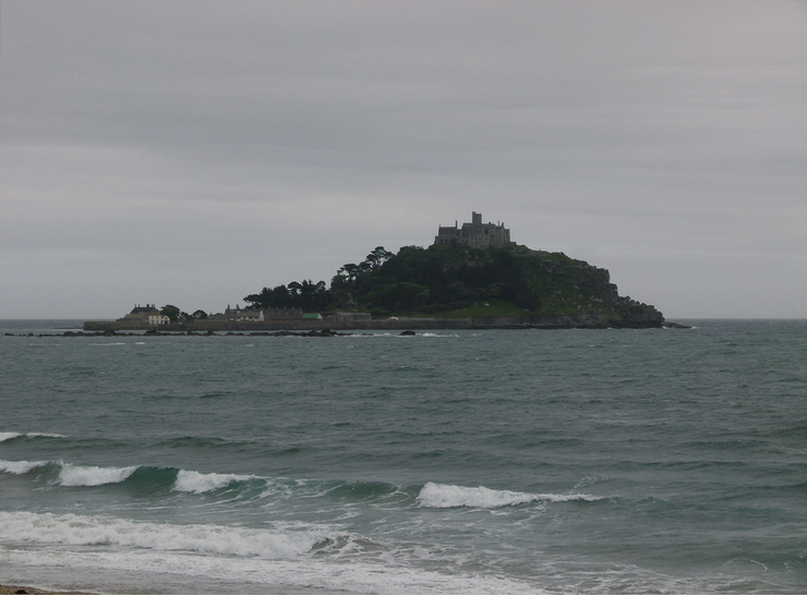


St Michael's Mount, Cornwall, England, UK