| Locality | Latitude | Longitude | Distance | Bearing |
|---|
| Craigahulliar Quarry, Portrush, Co. Antrim, Northern Ireland, UK | 55° 11' 27" N | 6° 37' 3" W | 0.0km (0.0 miles) | |
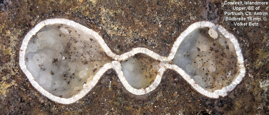
| Islandmore upper, Portrush, Co. Antrim, Northern Ireland, UK | 55° 10' 33" N | 6° 37' 48" W | 1.9km (1.2 miles) | |
| Port Ganny, Giant's Causeway, Co. Antrim, Northern Ireland, UK | 55° 14' 19" N | 6° 30' 51" W | 8.4km (5.2 miles) | |
| Port Noffer, Giant's Causeway, Co. Antrim, Northern Ireland, UK | 55° 14' 27" N | 6° 30' 27" W | 8.9km (5.5 miles) | |
| Bengore Head, Dunseverick, Co. Antrim, Northern Ireland, UK | 55° 14' 58" N | 6° 27' 59" W | 11.6km (7.2 miles) | |
| Dunseverick, Co. Antrim, Northern Ireland, UK | 55° 14' 9" N | 6° 26' 18" W | 12.4km (7.7 miles) | |
| Down Hill, Co. Londonderry, Northern Ireland, UK | 55° 9' 58" N | 6° 49' 23" W | 13.3km (8.3 miles) | |
| Larry Bane Quarry, Ballintoy, Co. Antrim, Northern Ireland, UK | 55° 14' 28" N | 6° 21' 4" W | 17.8km (11.1 miles) | |
| Cregganboy, Ballintoy, Co. Antrim, Northern Ireland, UK | 55° 13' 20" N | 6° 17' 32" W | 20.9km (13.0 miles) | |
| Keady Mtn, Co. Londonderry, Northern Ireland, UK | 55° 3' 35" N | 6° 51' 28" W | 21.1km (13.1 miles) | |
| Kinbane Head, Ballintoy, Co. Antrim, Northern Ireland, UK | 55° 13' 47" N | 6° 17' 25" W | 21.2km (13.2 miles) | |
| Magilligan, Co. Londonderry, Northern Ireland, UK | 55° 11' 12" N | 6° 57' 28" W | 21.6km (13.4 miles) | |
| Limavady, Co. Londonderry, Northern Ireland, UK | 55° 3' 1" N | 6° 57' 6" W | 26.4km (16.4 miles) | |
| Brockley, Rathlin Island, Co. Antrim, Northern Ireland, UK | 55° 18' 7" N | 6° 14' 22" W | 27.0km (16.8 miles) | |
| Murlough Bay, Co. Antrim, Northern Ireland, UK | 55° 12' 41" N | 6° 7' 7" W | 31.7km (19.7 miles) | |
| Glendun, Cushendun, Co. Antrim, Northern Ireland, UK | 55° 6' 44" N | 6° 7' 48" W | 32.2km (20.0 miles) | |
| Glenaan, Cushendall, Co. Antrim, Northern Ireland, UK | 55° 5' 20" N | 6° 7' 29" W | 33.3km (20.7 miles) | |
| Tievebulliagh, Cushendall, Co. Antrim, Northern Ireland, UK | 55° 4' 27" N | 6° 7' 58" W | 33.4km (20.8 miles) | |
| Glenravel Mines, Cargan, Co. Antrim, Northern Ireland, UK | 55° 0' 31" N | 6° 11' 13" W | 34.1km (21.2 miles) | |
| Ballynahavla Mine, Glenravel Mines, Cargan, Co. Antrim, Northern Ireland, UK | 55° 0' 38" N | 6° 10' 21" W | 34.7km (21.5 miles) | |
| Evishacrow Mine, Glenravel Mines, Cargan, Co. Antrim, Northern Ireland, UK | 55° 0' 36" N | 6° 10' 8" W | 34.9km (21.7 miles) | |
| Dungiven, Limavady, Co. Londonderry, Northern Ireland, UK | 54° 55' 59" N | 6° 55' 59" W | 35.0km (21.7 miles) | |
| Cargan, Co. Antrim, Northern Ireland, UK | 54° 59' 35" N | 6° 10' 55" W | 35.4km (22.0 miles) | |
| Dungonnell Mines, Cargan, Co. Antrim, Northern Ireland, UK | 54° 59' 13" N | 6° 9' 38" W | 36.9km (22.9 miles) | |
| Tieveragh, Cushendall, Co. Antrim, Northern Ireland, UK | 55° 4' 39" N | 6° 4' 3" W | 37.2km (23.1 miles) | |
| Cushendall, Co. Antrim, Northern Ireland, UK | 55° 4' 50" N | 6° 3' 50" W | 37.3km (23.1 miles) | |
| Disused Quarry, Dungonnell Dam, Ballymena, Co. Antrim, Northern Ireland, UK | 54° 59' 26" N | 6° 8' 27" W | 37.6km (23.4 miles) | |
| Dungonnell Dam, Ballymena, Co. Antrim, Northern Ireland, UK | 54° 59' 13" N | 6° 8' 17" W | 38.0km (23.6 miles) | |
| Waterfoot, Co. Antrim, Northern Ireland, UK | 55° 3' 37" N | 6° 3' 30" W | 38.4km (23.9 miles) | |
| Glenariff Valley, Garron Plateau, Co. Antrim, Northern Ireland, UK | 55° 1' 55" N | 6° 4' 45" W | 38.5km (23.9 miles) | |
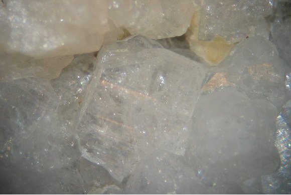


Craigahulliar Quarry, Portrush, Co. Antrim, Northern Ireland, UK