 | | Report (volume) | | Geology of the Conconully Quadrangle, Okanogan County, Washington By C. DEAN RINEHART and KENNETH F. FOX...BULLETIN 1402 Prepared in cooperation with the Washington Department of Natural Resources, Geology and...geology of the Conconully quadrangle, Okanogan County, Washington. (Geological Survey Bulletin 1402) Bibliography:...1. Geology-Washington (State)-Okanogan Co. I. Fox, Kenneth F., joint author. II. Washington (State). Geology...of Documents, U. S. Government Printing Office Washington, D. C. 20402 Stock Number 024-001-02845-0 CONTENTS |  | | Book | | Bart Cannon 1975 CORD ILLERAN Mercer Island, Washington Lilli liliiiLt' 111? KLi-KlLLLIlrVlIlI Copyright...Cordilleran 18 Holly Hill Drive Mercer Island, Washington 98040 COVER ILLUSTRATION: Amethyst scepter heads...milky quartz stems. Denny Mountain area of King County. Specimen from the collection of Cary A. Maykut...publications dealing with the various aspects of Washington State's diverse mineral wealth exist, but none..."Minerals of Washington" represents an attempt to begin such a cata logue. "Minerals of Washington" shall |  | | Journal (article/letter/editorial) | | 89507 Evolution of a Plutonic Complex, Okanogan Range, Washington ABSTRACT Plutonic events in the Toats...Toats Coulee Creek region of the Okanogan Range, Washington, are mainly determined by a textural and structural...the Toats Coulee Creek region of the Okanogan Range, Washington State (Fig. 1). The area contains a Cordilleran...Source partly IN THIS REPORT geologic map of Washington (Huntting and others, 1961) and geologic compilation...activi y in the Toats Coulee Creek region, Okanogan Range, Washington. I 1 Downloaded from https://pubs.geoscienceworld | 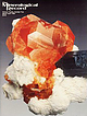 | | Journal (issue) | | of Victoria Melbourne, Australia Pete J. Dunn Washington, DC Peter G. Embrey London, England Richard C...Three mine pegmatites, Ramona district, San Diego County, California ............................101 by...Three property in the Ramona district, San Diego County, California. This mine, strictly speaking, is developed...for the other pegmatite gem mines in San Diego County, the collapse o f the Chinese tourmaline market...pegmatite. Coarse-grained albite and intermediate microcline-hosted perthite (Stern et al., 1986, Table 1) |  | | Journal (issue) | | fair crystals. lorado We decided to drive up Mt. Evans l very which was only a short distance away from...the way to Black H awk and Central City at Summit Lake at 12,740 feet in eleva1d tht which may be seen...molybdenite from Little Cottonwood Canyon near Salt Lake City, Utah, about lxl ½ feet; a 6x8 inch group of...quartz of lx3 feet from Custer County, South Dakota. On slopes of Mt. Evans, Colorado, ahuti- 12,000 feet...feet hip. ROCKS AND MINE 230 snow plow on Mt. Evans). We ate the lunch we had brought with us at Summit |
|


