 | | Journal (article/letter/editorial) | | Sciences University of Wisconsin-River Falls 410 South Third Street River Falls, Wisconsin 54022 his is Wisconsin’s... breweries, bratwurst, and Packers football, Wisconsin also has a diverse geology and a history rich...forgotten, abandoned, and overgrown. In this respect, Wisconsin represents a frontier state for the mineral collector...Vulcan Materials quarry in Racine (Scovil 1994), the pegmatites of Florence County (Koehier 1989) and...summarizes and highlights what has been found in Wisconsin in the past 150 years and points the way to new | 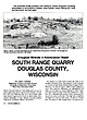 | | Journal (article/letter/editorial) | | and pink agate. Figure 1: North cut of the South Range quarry. Basalt flows strike parallel to the hill...Minerals in Keweenawan Basalt SOUTH RANGE QUARRY DOUGLAS COUNTY, WISCONSIN WILLIAM S . CORDUA Department...Earth Science University of Wisconsin—River Falls River Falls, Wisconsin 54022 M O S T C O L L E C T...exposed along streams or in pits. Few know that Wisconsin also has a good locality where Lake Superior agates...ROCKS & MINERALS The locality is a small quarry located just south of the Parkland Township dump, approximately |  | | Journal (article/letter/editorial) | | Minerals in Keweenawan Basalt, South Range Quarry, Douglas County, Wisconsin, W. S. Cordua, 412-415 Anatase...Robinson, S. Augelite, New Hampshire, 304 Augite, Wisconsin, 414 Barite: Colorado, 133, 143, 200-222; New...Minerals in Ke weenawan Basalt, South Range Quarry, Douglas County, Wisconsin, 412-415 Covellite, Colorado...215; New Hampshire, 290, 435; Ohio, 512-540; Wisconsin, 414 California State Mining and Mineral Muse...California, J. A. Bartsch, 42-48 Camp Bird Mine, Ouray County, Colorado, T. Rosemeyer, 114-149 Cares, J . W. |  | | Report (issue) | | (glacially carved basalt) 4 (3) 39 South Range Quarry South Quarry Volcanics Volcanics [PLy]) [PLV]) ...Keweenaw Fault) Fault) D4 D4 (Dl) (Dl) 139 139 South South Point point (view (view of of the the tip tip...positions positions during during the the Wisconsin Wisconsin ice iceretreat. retreat. 28 28 Figure 15:...ice-marginal ice-marginal positions during the Wisconsin Wisconsin ice ice retreat. 29 Figure Figure 16; 16:...Geologic Geologic profile of the the South South Range Range Quarry. Quarry. 38 Figure 21: 21: Cross section |  | | Journal (article/letter/editorial) | | occurrences. These localities have been listed by county; and, strictly for convenience, the list has been...None theless, with the aid of a good state or county map, plus local inquiries, the list could be helpful...Wayne County International Salt C o . mine—Detroit Alpena County National G y p s u m C o . quarry (formerly...(formerly the Huron-Portland Ce ment Co. quarry)—Alpena barite, calcite, chalcopyrite (r), dolomite,...marcasite, pyrite, sphalerite, strontianite (r) Paxton quarry—Paxton calcite, chalcopyrite, dolomite, marcasite |  | | Report (issue) | | United States Geological Survey. University op Wisconsin, Department of Geology and Mineralogy, Madison...Series Chapter VI.— The Keweenaw an Rocks op the South Shore of Lake Superior Introductory 152 Section...The South Range Section IV. The Region between the Ontonagon River and Numakagon Lake of Wisconsin, including...Porcupine Mountains Section V. NoRTH^VESTERN Wisconsin and the adjoining part of Minnesota Chapter VII...olivine-free gabbros Fig. —From half a mile southwest of south point of Beaver Bay, Minn. 24 35 1. N. W. i |  | | Book | | ....243 APPENDIX II: MINERAL SPECIES LISTED BY COUNTY ...............................248 ABOUT THE AUTHORS...shallow nested spoons whose long axis trends north-south (Figure 2). At the center of the basin, just west...Marquette County include the Presque Isle body, the Yellow Dog body in the northern part of the county, and...Ishpeming. Several bodies also occur in Dickinson County near the mouth of the Sturgeon River. A distinctive...outcrops in the SW¼ section 27, T44N, R31W, Iron County, about 1.6 kilometers west of Lake Ellen, and about |  | | Journal (issue) | | not only of copper and silver but also of a wide range of other species, many of them still collectible...French outpost near modem Ashland, Wisconsin. He searched the south shore of Lake Superior for copper...as far west as Minnesota’s St. Louis River, and south to the boundary of previously acquired lands. The...that governed lead mining already in progress in Wisconsin. The War Department was placed in charge of supervising...exploiting “fis sure deposits” in Keweenaw or Ontonagon County. Prime targets were large veins of solid copper |  | | Report (issue) | | (CaBSiO4OH) vesicle filling from a basaltic Houghton County lava flow. Small specks of native copper occur...exceptionally fine, twinned analcite crystals from Houghton County ························-··-······-··-········...····· 41 2. Ankerite on siderite from Alpena County ···-··············-··················· 46 3....stalactitic limonite from Negaunee in Marquette County .................................................(Hexagonaria percarinata) of calcite from Charlevoix County .. ..... .. ....... ...... .. ............... |  | | Book (volume) | | Illinois, the glacial drift of the Late Pleistocene Wisconsin glaciation, the bluffs and detritus of the Ohio...feet thick in the south, grading to 600 to 800 feet thick in the north. ALEXANDER COUNTY FAYVILLE, area...⎯agate, jasper; d RR siding of Clay⎯agate. CALHOUN COUNTY AREA, shores of the Mississippi R., in the Warsaw...crystals). CRAWFORD COUNTY PALESTINE, area deposits⎯Siderite. EDWARDS COUNTY AREA, T. 1 S, R. 10 E...E, regional deposits⎯Siderite. FULTON COUNTY FARMINGTON, W 6 mi. on Rte. 116 to the Rapatee No. 5 strip |  | | Book (volume) | | Illinois, the glacial drift of the Late Pleistocene Wisconsin glaciation, the bluffs and detritus of the Ohio...feet thick in the south, grading to 600 to 800 feet thick in the north. ALEXANDER COUNTY FAYVILLE, area...⎯agate, jasper; d RR siding of Clay⎯agate. CALHOUN COUNTY AREA, shores of the Mississippi R., in the Warsaw...crystals). CRAWFORD COUNTY PALESTINE, area deposits⎯Siderite. EDWARDS COUNTY AREA, T. 1 S, R. 10 E...E, regional deposits⎯Siderite. FULTON COUNTY FARMINGTON, W 6 mi. on Rte. 116 to the Rapatee No. 5 strip |  | | Book (volume) | | Dahlonega Co. and Rabum Co., and the McDuffie County Belt extending through portions of McDuffie, Warren...Sphalerite. BALDWIN COUNTY MILLEDGEVILLE, at state farmjasper. BANKS COUNTY COMMERCE, along Hwy. 59...along adjoining Co. linerock crystal. BARROW COUNTY WINDER, along rd. to Jefferson and 1½ mi. inside...Guide for Rock Hounds in the United States BARTOW COUNTY AREA, Saltpeter Cave, as floatjasper. CARTERSVILLE:...(banded, various colors), jasper. BIBB COUNTY MACON: at Holton Quarry, 7½ mi. NWagate; N of Calloway |  | | Report (issue) | | connected with the industry a I'e solved. The Mesabi range has probably reached its zenith in less than fifty...tons of low-grade iron-bearing material on that range, and it is not too early to plan for its utilization... . . . . . . . . . . . . . . . . .. The Mesabi Range. . . . . . . . . . . . . . . . . . . . . . . . ... . . . . . . . . . . . . . . . .. The Gunflint Range. . . . . . . . . . . . . . . . . . . . . . . . .... . . . . . . . . . . . . . . .. The Cuyuna Range. . . . . . . . . . . . . . . . . . . . . . . . . . |  | | Journal (article/letter/editorial) | | Natural History cluded the Balkan states and the South Museum in Vienna. Unfortunately the Tyrol which...The towns and the cities near the mining central range is igneous and produces areas. many fine specimens...locating the towns. There are two more. The south range is limestone. sets of maps available which show...these ranges when N . E . S . W — N o r t h , East, South. West not in operation are under snow except R —...Tunnel—Tunnel. Graben—Ditch or trench. Grube—Open pit or quarry. Knopf—Head or top of mountain. K o g e l - - D |  | Bodden, Thomas, Bornhorst, Theodore, Bégué, Florence, Deering, Chad (2022) Sources of Hydrothermal Fluids Inferred from Oxygen and Carbon Isotope Composition of Calcite, Keweenaw Peninsula Native Copper District, Michigan, USA. Minerals, 12 (4) 474 doi:10.3390/min12040474 | Journal (article/letter/editorial) | | Keweenaw Peninsula Native Copper District, Michigan, USA Thomas J. Bodden 1 , Theodore J. Bornhorst 1,2, *...Keweenaw Peninsula Native Copper District, Michigan, USA. Minerals 2022, 12, 474. https://doi.org/10.3390/...Michigan Technological University, Houghton, MI 49931, USA; tjbodden@mtu.edu (T.J.B.); cddeerin@mtu.edu (C.D...Michigan Technological University, Houghton, MI 49931, USA Department of Earth Sciences, University of Geneva...interflow clastic sedimentary rocks within the PLV range from a few cm up to 40 m thick and consist of red-colored |  | | Report (volume) | | ......... South Carolina......................................:.................... South Dakota................................................... Wisconsin.................................................Arkansas, California, Colorado, New Mexico, Oregon, South Dakota, Tennessee, and Texas; to list all the literature...Catalogue of the mineral localities of South Carolina: South Carolina Geol. Survey, ser. 4, Bull. 2,...1908. Scott, Samuel, Map of the Black Hills of South Dakota and Wyoming, with full descriptions of mineral |  | | Journal (issue) | | Contents for July-August, 1950 CHIPS FROM THE QUARRY ................................................................. 363 WORLD'S LARGEST SANDSTONE QUARRY ............ ....................................--v,-- _ ......... ,., :,,..v CHIPS FROM THE QUARRY ---------------•••-••_,..............,..._,..,...for 1950 June 4 -· Strickland Quarry, Portland, Cooo. June 18 - Silox Quarry, No. Stonington, Conn. July...September 24 - Westfield, Mass. October 8 - Slocum Quarry. October 22 - To Be Announced. November 5 - To |  | | Report (volume) | | inch Fig. 1. Plat of exposures. Fig. 2. Profile of south bank, showing exposures. Fig. 3. Generalized section...section, showing structure. 49 XIII. Torch Lake Quarry, Keweenaw Point. From a photograph e XIV. Junction...Fig. 1. Plat of exposures. Fig. 2. Elevation of south bank, showing exposures. Fig. 3. Generalized section...Junction of Eastern Sandstone and Keweenawan diabase, south side of Douglass Houghton Ravine, Keweenaw Point...of quartz fragments from sandstone of Torch Lake Quarry, Keweenaw Point. Scale, 67 diameters........e 53 |  | | Journal (issue) | | • • • ♦ • • • • • 131 CHIPS FROM THE QUARRY !Edi torial Page ) . . . . . . . . . . . . . ....( t f ii b s C b 11' PREHN ITE New Street Quarry, Paterson, N . J. cc M ti' in ar er t i1...Prehn who first found it at Cape of Good Hope in South Africa. Prehnite is now a common mineral at many...uncovered in the basal t wall of the lower New Street quarry, Paterson, which was 3 x 3 feet in area and over...follows : Cape Chrysolite: green prehnite from South Africa . Chlorastrolite: Impure prehnite from Lake |  | | Journal (article/letter/editorial) | | approximately 13 km north of Murfreesboro, Pike County, Arkansas, USA. Occurrence: In fractures in the Jackfork...phosphate–hydroxide from the Funderburk prospect, Pike County, Arkansas, U.S.A. Canadian Mineralogist 41, 721-725...of section 34, Township 24 South, Range 11 East, Emery County, Utah, USA. Occurrence: In a silicified...Robert (Bob) Jones (b. 1926), of Cave Creek, Arizona, USA, in recognition of his enormous contribution to the...new mineral species from Temple Mountain, Emery County, Utah, U.S.A. Canadian Mineralogist 41, 83-90. |  | | Book | | Fossils in America A Range Guide to Mines and Minerals The Rock-Hunter's Range Guide Petrified Forest...different form in A Range Guide to Mines and Minerals and The Rock-Hunter's Range Guide, both by Jay Ellis...Oklahoma Oregon Pennsylvania Rhode Island South Carolina South Dakota Tennessee Texas Utah Vermont Virginia...Virginia Washington West Virginia Wisconsin Wyoming Appendixes 615 I Gemstone and Mineral Essentials 617...Rock-Hunter's Range Guide (Harper & Row, 1962) dealt primarily with how and where to seek gemstones. A Range Guide |  | | Report (Issue volume) | | State mineral production and mineral production by county were prepared in the Division of Statistics and...Environmental Management. South Carolina: South Carolina Geological Survey. South Dakota: South Dakota Geological...Virginia Geological and Economic Survey. Wisconsin: Wisconsin Geological and Natural History Survey. Wyoming:... . . . . . . . . . . . . . . . . . • • • • • • South Carolina, by Steve W . Sikich and Norman K. Olson... . . . . . . . . . . . . . . . . . • . . • • • South Dakota, by James H. Aase . . . . . . . . . . . |  | | Report (volume) | | of Kentucky Geol. Survey County Rept. - Kentucky Geological Survey County Report. University of Kentucky...Analysts. Houston, Tex. Los Angeles County Mus. Contr. Sci. - Los Angeles County Museum Contributions in Science...Science. Los Angeles County Museum of Natural History. Los Angeles, Calif. Los Angeles County Mus. Nat. History...History Quart.- Los Angeles County Museum of Natural History Quarterly. Los Angeles, Calif. Louisiana Water...Dartmouth, Nova Scotia, Canada. Maryland Geol. Survey County Geol. Map Geologic Map. Baltimore, Md. Maryland |  | | Journal (article/letter/editorial) | | point on the mine dumps increase in number. At South Range from the Baltic # 2 anchorite, chalcocite, bornite...Isle Royale, Huron. On the Huron dumps are found laumontite with diopside and epidote. This makes it a strikingly |  | | Journal (article/letter/editorial) | | with greenstone differentiates.. 196 Flow at South Rang! quarry 168 Origin of the copper deposits 96 "Big»trap...section of a pegmatitic lava flow at South Range Quarry, Houghton County, Michigan 202 olivine-rich basalt...glomeroporphyrites contain nawan rocks are bounded on the south by a phenocrysts of plagioclase which tend to clot...contain layers, lenses, or iris bounded on the south by the Keweenaw regular masses in which the minerals...layers, lenses, and basaltic andesites. Other types range from and spots of altered, amygdaloidal, coarseINTRODUCTION |
|


