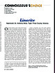
 | | Journal (article/letter/editorial) | | Linarite Mammoth–St. Anthony Mine, Tiger, Pinal County, Arizona O f the blue minerals, azurite is likely...surfaces. Linarite is a basic sulfate of copper and lead with the formula of PbCu(SO4)(OH)2. It is easily...oxidized parts of deposits originally containing lead and copper sulfides. It is most frequently encountered...including the Cape Rosier mine at Brooksville, Hancock County, where it was found with smithsonite as 1–2-mm...Galena King mine), Coos County, and Mineral Hill near Wakefield, Carroll County, New Hampshire. It was |  | | Report (issue) | | REVERE Fy -, . 56th Annual Report MINING INDUSTRY OF IDAHO for 1954 GEORGE EDWARD VIOLET 2 4... Governor of Idaho. Sir: In compliance with the provisions of Section 47-111, Idaho Code, I have...19 eee els Yi 17 33-41 SL oI anes a Maan Idaho Bureau of Mines, Directors Annual Leta et) 2 ...2--2-225. ea, County Bear Lake Benewah ................ 96 (Sia stlinore; County, <=... 100 trankiineg...Countyse 22.2. 102 County _........-... (Oe remont 103 8 OMe Geri County S0Bedaho. Boise C@ounty~- |  | | Report (issue) | | Reconnaissance of the ore deposits in northern Yuma County, Ariz.: Bull. 451, 130 pp., 1911. 30c. -. The ore...H., Geology and ore deposits of the Park City district, Utah: Prof. Paper 77, 231 pp., 1912. BROOKS,...The mineral deposits of Alaska and the Alaskan mining industry in 1913: Bull. 592, pp. 1-74, 1914. 413...1913, PART i. BROOKS, A. H., The Chisana placer district, Alaska: Bull. 592, pp. 309-320, 1914. Gold, silver...BUTLER, B. S.,'and DUNLOP, J. P., Silver, copper, lead, and zinc in the Central States in 1913 (mines report) |  | | Report (issue) | | DARWIN SILVER-LEAD MINING DISTRICT, CALIFORNIA. By ADOLPH KNOPF. INTRODUCTION. Most of the lead ore produced...districts, all in Inyo County, in the eastern part of the State. The Cerro Gordo district has been by far the...prosperous years $7,000,000 in argentiferous lead. The Darwin district has probably yielded between $2,000,000...000. The geologic features of the Cerro Gordo district have recently been described by the writer,1 and...present report to describe those of the Darwin district. The data on which this report is based were obtained |  | | Journal (issue) | | large mine and smelter. Employment in the state's mining industry increased 13 percent over last year --...the Buffalo mine in the Granite district of eastern Grant County * Mining Engineer, State of Oregon Dept...diatomite, gem stones, conducted a diamond drilling lead, nickel, silver, zinc. program to determine mineralization...mine near Jumpoff Joe Creek in northern Jo~ephine County. Reopening work was conducted by Lloyd Frizzell...southwest of Grants Pass in southern Josephine County was explored during the year by McPhar Geophysics |  | | Book | | AND MINING AREAS SLICK ROCK DISTRICT GYPSUM VALLEY DISTRICT BULL CANYON DISTRICT URAVAN DISTRICT GATEWAY...GATEWAY DISTRICT (EASTERN GATEWAY AREA) MC ELMO CREEK DRAINAGE AREA LA SAL CREEK AREA PARADOX DISTRICT BEAVER...VALLEY (BIG INDIAN) DISTRICT MOAB DISTRICT GREEN RIVER DISTRICT THOMPSONS DISTRICT INTER-RIVER REGION...REGION DRY VALLEY DISTRICT COTTONWOOD AND BUTLER WASH AREAS MONTEZUMA CANYON DISTRICT SEVEN-MILE CANYON...PLATES Paradox Basin Uranium Districts Uranium Mining Areas Within Districts Paradox Basin Domes and |  | | Report (issue) | | said to have been found in the mining the nugget Jim, Placer County, California, in 1871 by a small...Counties of California: Minerals and mineral lists Mining Districts of California Unvalidated entries in...The bibliography has been updated and expanded. County lists published by Collins (1) pp. 40-64, in Murdoch...resulting from references to the geographic term ''Mining District," especially in the pre-1920 literature. Widespread...rhyolite locality in Alameda County and the lawsonite type locality Marin County, which have been completely |  | | Book (volume) | | ae TONITE TN263. Au. =American Institute of Mining, Metallurgical, V.2 and Petroleum Engineers Ore...Inst! itute i an Americ ie Lye 2 of llurgical, Mining, Meta m Engineers and Petroleu © f the Ore deposiits...121, METALLURGY OF LEAD AND ZINC (1936) 134, MILLING METHODs 141, METAL MINING (1939) (1937-40) BLAST...AIME TRANSACTIONS VOLUME 178, MINING GEOLOGY AIME TRANSACTIONS 181, MINING, INDUSTRIAL MINERALS, EDUCATION...I! Published by : : The American Institute of Mining, Metallurgical, and Petroleum Engineers, Inc. NEW |  | | Book | | P. Blake, professor of mineralogy, geology and mining at the College of California, parent to the University...California, and published in the fourth and sixth State Mining Bureau reports. Then beginning in 1914 with a volume...are reported by county of occurrence. Map 1-2 shows the county boundaries and county names. When possible...,o Map 1-2. Outline map of California showing county boundaries. __ _) 4 MINERALS OF CALIFORNIA...Continued Symbol Iodine Iridium Iron Krypton Lanthanum Lead Lithium Lutecium Magnesium Manganese Mercury I |  | | Report (issue) | | rewhich was publi.shed as Bulletin 67 of the State Mining Bureau. vision by the same author in 192-3 increased...tribes in the northeast corner of San Bernardino County in pre-historic times. The old workings here were...desert region between Death Valley and Goff's Mining District, nearer the former, and that good samples were...the museum of the Bureau. * * * "The turquoise district, as described by Mr. Eisen and others of the party...east of Lindsay, Tulare County near mouth of Carrizo Gorge, San Diego County west side of Williams Valley |  | | Book | | milky quartz stems. Denny Mountain area of King County. Specimen from the collection of Cary A. Maykut...DESCRIPTIONS 21 ABBREVIATIONS 24 GLOSSARY 25 COUNTY INDEX OF MINERAL OCCURRENCES 29 MINERAL DESCRIPTIONS...(using a code explained on page 21) and a county by county list mentioning the nature of their occurrence...Parks and Monuments prohibit all collecting. state, county and city parks usually prohibit collecting. Please...ZONE OF METALLIC ORE DEPOSITS a. b. DERIVED FROM LEAD AND ZINC DEPOSITS Cerussite, anglesite, leadhillite | | | Book | | P. Blake, professor of mineralogy, geology and mining the at College of California, parent to the...mineralogist of California, and pub- and sixth State Mining Bureau reports. Then beginning volume prepared...species are reported by 1-2 shows the county boundaries and county names. When possible, locations of mines...within a township is illustrated by Figure 1-1. county of occurrence. Map *M. Fleischer’s 1980 Glossary...Map 1-2. Outline map of California showing county boundaries. 4 MINERALS OF CALIFORNIA R5W i |  | | Report (issue) | | RESOURCES OF KERN COUNTY CALIFORNIA CALIFORNIA DIVISION OF MINES AND GEOLOGY COUNTY REPORT 1 i y 1966... Front cover: The exceedingly varied terrain of Kern County is shown by the brown section— from McKittrick...Sierra Nevada and Owens Peak (highest point in the county); on the east (right side) is the sharp descent...MINERAL RESOURCES OF KERN COUNTY, CALIFORNIA By BENNIE W. TROXEL, mining geologist California Division...MORTON, and Geology mining geologist California Division of Mines and Geology County Report f Ferry Building |  | | Report (issue) | | Geology and Ore Deposits of the Rico District, Colorado GEOLOGICAL SURVEY PROFESSIONAL PAPER 723...723 Geology and Ore Deposits of the Rico District, Colorado By EDWIN T. McKNIGHT GEOLOGICAL SURVEY ...which~ under modern mineral technology~ became a lead, zinc, and pyrite camp UNITED STATES GOVERNMENT...------------------------------------Location and geography of district -----------History --------------------------...PLATE 1. 2. 3. Geologic map and section of Rico district, Colorado. Maps showing geology of Nos. 4, 5, |  | | Book | | Complex Kookabookra • Bear Hill district Rockvale· Fishington district Deposits in and adjacent to the...Epigenetic deposits ,.. Marengo - Dundurrabin - Dorrigo district Deposits in and adjacent to the Dundurrabin Granodiorite...Taylors Ann district ,... Munga Creek district Granitoid-Related Deposits Guyra . Vralla district Llangolhlin...Adamellite Vralla Granodioirite ,..... Oban - Backwater district ;...............................................Coastal granitoid belt Valla - Nambucca district Yarrabapinni district Discussion ,.............. Kellys Creek |  | | Book (edition) | | unrealized expectations that our rigid format would lead to a high degree of internal consistency. Even at...the Fuernrol No. 2 mine, Temple Mountain, Emery County, Utah; also sparsely disseminated in uraniferous...in the Cave Hills and Slim Buttes areas, Harding County, South Dakota. BEST REF. IN ENGLISH: Thompson,...rnine , Silver Plun1e district, and at the Little Emma mine, Clear Creek County; at the Enterprise n1ine...n1ine, Dolores County; and at the Double Header lode , Su1nmit County . rt is also found in Canada, Mexico |  | | Book (edition) | | Lincoln. Encyclopedia of minerals Sagiiache County Pu blic Library Saguache , Colorado DEMCO For...Photo Editor: Wendell E. Wilson Library Saguache County Public Saguache, Colorado VAN NOSTRAND REINHOLD...oil shale of the Green River Formation, Uintah County, Utah, associated with authigenic orthoclase, pyrite;...the Fuemrol No. 2 mine, Temple Mountain, Emery County, Utah; also sparsely disseminated in uraniferous...in the Cave Hills and Slim Buttes areas, Harding County, South Dakota. SELECTED REFERENCES: Thompson, M | | | Book (edition) | | Willard Lincoln. Encyclopedia of minerals ~~cbe County Public Library Saguache, Colorado OEMCO For Refere...the Fuemrol No. 2 mine, Temple Mountain, Emery County, Utah; also sparsely disseminated in uraniferous...in the Cave Hills and Slim Buttes areas, Harding County, South Dakota. SELECTED REFERENCES: Thompson, M...oil shale of the Green River Formation, Uintah County, Utah, associated with authigenic orthoclase, pyrite;...Dives m.ine, Silver Plume district, and at the Little Emma mine, Clear Creek County; at the Enterprise mine |  | | Book | | states of Guanajuato and Chihuahua, Mexico. In the USA silver occurs at Keweenaw, Michigan, in association...Butte, Montana, as well as Colorado, Arizona and Idaho. In Canada it occurs at Cobalt, Ontario. Treatment...Corocoro, Bolivia, and at Cananea, Mexico. In the USA copper is found in abundance in the Keweenaw area...Australia. In the USA gold is often obtained by individual prospectors by placer mining. It is found along...low. Graphite C Graphite, sometimes called black lead, crystallizes in the hexagonal system as flat six-sided |  | | Report (issue) | | Paper 172 GOLD QUARTZ VEINS OF THE ALLEGHANY DISTRICT CALIFORNIA BY HENRY G. FERGUSON AND ROGER W...mine----_---------Finan prospect. ________________ Kate Hardy mine__--------__-_Hardy Kate prospect--_---_^--_Tomboy...prospect___-----____:_-.Eureka mine. _____^-__ __________ Oak prospect..---.-.--.... _____ in 45 45 46 46 47 47 47 48... Mugwump mine_-_-_-_______-__.-____. Gold Bug prospect._.__________________ Federal mine.________________________...Roye-Sum prospect-__________________ Oriental mine ________________________ Frances D prospect,___________________ |  | | Report (issue) | | Eldridge Glacier and Partin Creek) Site type: Prospect ARDF no.: TK002 Latitude: 62.9944 Quadrangle:...149.9363 Location description and accuracy: This prospect is at an elevation of about 3,000 feet on a spur...Gangue minerals: Quartz Geologic description: This prospect consists of quartz veins(?) in chert and argillite...name(s): Unnamed (near Partin Creek) Site type: Prospect ARDF no.: TK003 Latitude: 62.9563 Quadrangle:...149.9332 Location description and accuracy: This prospect is at an elevation of about 1,600 feet on the |  | | Book | | earlier stage in their development fashioned gems; to lead those who have already tion about minerals that...form empty In view of this it is reasonable to wonder why the nuclei of adjacent atoms do not collide...metal and sulphur in a variety frequently phides mining that of structures, covalent than will you...country. Above. Southwestern England, a traditional mining area. Colours show rock types. Black is dolerite... include descriptions of mineral occurrences, mining areas and so on. These, together with papers in | | | Book | | of the world of minerals and fashioned gems; to lead those who have already made a first acquaintance...Hydrogen Indium Iodine Iridium Iron Krypton Lanthanum Lead Lithium Lutetium Magnesium Manganese Mercury Molybdenum...empty space. In view of this it is reasonable to wonder why the nuclei of adjacent atoms do not collide...sul¬ phides that you will meet frequently outside mining areas are those of iron, namely pyrite, FeS2, and...country. Above: Southwestern England, a traditional mining area. Colours show rock types. Black is dolerite |
|


