 | | Report (issue) | | Prepared in cooperation with the Colorado Geological Survey for the United States Department of Agriculture...Service Development of Industrial Minerals in Colorado Circular 1368 U.S. Department of the Interior...Survey Development of Industrial Minerals in Colorado By Belinda F. Arbogast, Daniel H. Knepper, William...John S. Dersch Prepared in cooperation with the Colorado Geological Survey for the United States Department..., 2011, Development of industrial minerals in Colorado: U.S. Geological Survey Circular 1368, 87 p. Library |  | | Report (issue) | | RECONSTRUCTION OF SEASCAPE IN GLASS MOUNTAIN AREA, BREWSTER COUNTY, TEXAS, DURING MIDDLE PART (LEONARD) OF PERMIAN...John Chronic and W. O. Thompson, University of Colorado; C. C. Branson, University of Oklahoma; R. K....California Co.; W. R. Atkinson and H. R. Wingerter, Colorado Oil & Gas Corp.; J. W. Strickland, Continental..._________________________________ (I) Western Colorado, southern Utah, and northwestern New Mexico, by...in the George's Creek basin of western Allegany County, Md. In the Allegheny region, rocks of Early Permian |  | | Report (issue) | | ]3E~rW]~]£N OF GEOLOGIC FORMATIONS EASrr-CENTllAL COLORADO, CENTRAL WYOMING AND SOU~rHEllN MONTANA BY 'VILLIS..._________________________ _ Locu.liticl:l in foothills of Colorado _______________ _ Colorttdo Spri ngs ________________...Bibber Canyon _______________________ _ Ralston Canyon __________________________ _ Eldorado Canyon ___________...MountaitL _______________ ..: ________ _ Cottonwood Canyon ______________________ _ L __________________...details-Continued, Localities in foothills of Colorado-Continued, Thompson Canyoll_________________________ |  | | Report (volume) | | Geology and Hydrology, Front Range Urban Corridor, Colorado By FELICIE CHRONIC and JOHN CHRONIC GEOLOGICAL...Corridor. It was compiled at the University of Colorado, funded by the U.S. Geological Survey, and is...Institute bibliographies, as well as those of the Colorado Geological Survey. Most of the material listed...Federal Center, the Colorado Geological Survey office in Denver, the University of Colorado Library, or the...the Colorado School of Mines Library. These are available at the school where they were written. Microfilm |  | | Report (issue) | | northeastern Utah and northwestern Colorado. The Chinle Formation of the Colorado Plateau and the Uinta Mountains...Wyoming ap proximately equals the Glen Canyon Group of the Colorado Plateau. The Temple Cap Sandstone of...of southwestern Utah equals the Gypsum Spring Formation and the Gypsum Spring Member of the Twin Creek...western Wyoming and of the Carmel Formation in the Colorado Plateau, at their respective type localities...but none of these correlate with any part of the Gypsum Spring Formation of Wyoming. The Curtis Formation |  | | Book (edition) | | MILEAGE L OGS. REVISED EDITION Revised Edition, COLORADO GEM TRAILS AND MINERAL GUIDE HICllAHD :--1. PEARL...an extensive ¥em and mineral collecting tour 01 Colorado, revealing the interesting places where Nature...Swallow, Publisher) 2679 South York Street Denver, Colorado 80210 - , =· - ·, BOOKS BY RICHARD M. PEARL...PEARL Exploring Rocks, Minerals, Fossils in Colorado America's Mountain: Pikes Peak and the Pikes Peak...Atlas of Colorado American Gem Trails Nature As Sculptor: A Geologic Interpretation of Colorado . Scenery |  | | Report (issue) | | Inc. 3300 Penrose Place, P.O. Box 9140, Boulder, Colorado 80301 Printed in U.S.A. GSA Books Science Editor...Fault Models Using Miocene Syntectonic Strata, Colorado River Extensional Corridor, Southeastern California...summarize stratigraphic relations throughout the Colorado River extensional corridor and use this information...919, Box 25046, Denver Federal Center, Denver, Colorado 80225 S. C. Good Department of Geology, State...963, Box 25046, Denver Federal Center, Denver, Colorado 80225 ABSTRACT A study integrating sedimentology |  | | Journal (issue) | | Julius Weber Mamaroneck, New York COLORADO ISSUE #2 Articles Colorado locality index.............................. 323 by B. L. Muntyan What’s new in Colorado minerals? ......................................339 by M. I. Jacobson The San Juan Mountains of Colorado ..................................349 by J. A...10 cm tall, from the Yucca Hill claim, Park County, Colorado. Richard A. Kosnar specimen; photo by John...Natural History for conceiving the idea of a second Colorado issue and for helping a great deal in bringing |  | | Book (edition) | | — _ ; COLORADO GEM TRAILS AND MINERAL GUIDE ! ■ : ' BOOKS BY RICHARD M. PEARL Colorado Gem Trails...Trails and Mineral Guide Colorado Rocks, Minerals, Fossils America’s Mountain: Pikes Peak and the Pikes...Nature As Sculptor: A Geologic Interpretation of Colorado Scenery Guide to Geologic Literature Popular Gemology...Gemology Mineral Collectors Handbook Colorado Gem Trails The Art of Gem Cutting (With Dr. H. C. Dake)...Dake) * RICHARD M. PEARL ★ COLORADO GEM TRAILS AND MINERAL GUIDE ★ SKETCH MAPS BY MIGNON WARDELL PEARL |  | | Report (volume) | | Selected Annotated Bibliography of Gypsum and Anhydrite in the United States and Puerto Rico By CHARLES...geographic occurrences, origin, technology, and uses of gypsum and anhydrite UNIT.ED STATES GOVERNMENT PRINTING...Francis, 1920comp. Selected annotated bibliography of gypsum and anhydrite in the United States and Puerto Rico...S. Geological Survey. Bulletin 1105) 1. Gypsum-Bibl. 2. Gypsum-U.S. 3. Anhydrite--Bib!. 4. Anhydrite-U...______________________________________________ Gypsum and anhydrite_____________________________________________ |  | | Report (issue) | | locality map of mercury-sulfur-gypsum mineralization at Crater, Inyo County, California By M. S. Erickson...PLA TE 1. Location map of the Crater Area, Inyo County , California 2 Map showing geology and rock sample...t1ercury-Sul fur - Gypsum Cal i fo rn i a ••• t~ineral i zed Area, Inyo County, ....................14 INTRODOCTION The Crater mercury-su l f ur-gypsum ~ineral ized area is located in eastcentral California...can be extreme in some places, as at Hanging Rock Canyon (plate 1). The climate is arid, and there are no |  | | Report (issue) | | Rezak—————————— Geology of the Du Noir area, Fremont County, Wyoming, by William R. Keefer_______________———————...(Early Cretaceous) age in the Rocky Mountains and Colorado Plateau. Of the 14 species •occurring in the Morrison...the species. In the Morrison formation of the Colorado Plateau, the small spiral parts of the fruiting...fceds of limestone in the Morrison of central Colorado, central Wyoming, and western South Dakota. The...Wash member of the Morrison formation in western Colorado, about 60 percent of the samples contained microfossils |  | | Report (volume) | | Minerals of Colorado: A 100- Year Record By EDWIN B. ECKEL GEOLOGICAL SURVEY BULLETIN 1 1 14 A...knowledge____________________________________ Future of Colorado mineralogy______________________________________...mineral localities and metallic mineral deposits of Colorado ________________________________ In pocket III...mineral localities and metallic mineral deposits of Colorado, has not been included in this reprint. Many of...especially Fischer and others, 1946). MINERALS OF COLORADO: A 100-YEAR RECORD By EDWIN B. EcKEL ABSTRACT |  | | Report (volume) | | SURVEY GEOKGE OTIS SMITH, Director Bulletin 697 GYPSUM DEPOSITS OF THE UNITED STATES BY R. W. STONE....................... Mineralogy and geology of gypsum, by R. W. Stone....................... Chemical..................................... Analyses of gypsum, by R. W. Stone..................................in the chemical analysis of gypsum, by George Steiger............ The gypsum industry, by R. W. Stone......... Cost of gypsum plaster...... I................................... Uses of gypsum.............. |  | | Journal (article/letter/editorial) | | in the habit of elongated thin black calcite or gypsum in many localities, are not beta-quartz, crystals...would 1986 in Altavista, correspond to a Campbell County, diamond octahedron Virginia, where of up to 8...environments other than the marls and (Calvo, 2018). gypsum of the Triassic these pseudomorphs have indeed...as Las Animas, Bent Co., and Owl Canyon, Larimer Co., both in Colorado, and in Buffalo Creek, Selman...Asturias (Calvo, 2012). Gypsum pseudomorphs after glauberite The transformation of gypsum into glauberite represents |  | | Report (issue) | | A late Tertiary low-angle fault in western Juab County, Utah, by D. R. Shawe _______________________________...part of the Timber Mountain dome and caldera, Nye County, Nev., by W. J. Carr_____________________ Diverse...Zonal features of an ash-flow sheet in the Piapi Canyon Formation, southern Nevada, by P. W. Lipman and...Jr______________ Flood inundation mapping, San Diego County, Calif., by L. E. Young and H. A. Ray_________...hydraulic properties of glacial outwash in Portage County, Wis., by E. P. Weeks------------------------- |  | | Report (volume) | | A. F. Rogers, Stanford University, Palo Alto. Colorado.........Prof. R. D. George, Boulder. Connecticut...See Bauxite and Hallpysite. Asbestos. Tallapoosa County, with corundum deposits near Dudleyville; not found...commercial quantity or quality. Asphalt. Colbert County, small quantity has been shipped from near Leighton;...following localities: Bibb County, Pratts Ferry; Calhoun County, near Tampa; Clay County, T. 20, Pv. 7 E.; Jefferson...Jefferson County, at Elyton; Lee County, at Chewacla lime works; St. Clair County, at Gfeensport; Shelby |  | , , DUNBAR, CARL O., BAKER, ARTHUR A., ARTHUR COOPER, G., KING, PHILIP B., McKEE, EDWIN D., MILLER, ARTHUR K., MOORE, RAYMOND C., NEWELL, NORMAN D., ROMER, ALFRED S., SELLARDS, E. H., SKINNER, JOHN W., THOMAS, HORACE D., WHEELER, HARRY E. (1960) CORRELATION OF THE PERMIAN FORMATIONS OF NORTH AMERICA. Geological Society of America Bulletin, 71 (12) 1763 doi:10.1130/0016-7606(1960)71[1763:cotpfo]2.0.co;2 | Journal (article/letter/editorial) | | section showing facies changes east of the Grand Canyon region 1774 2. Diagrammatic section of the Capitan...'Permian System' we refer the chief deposits of gypsum of Arzamas, of Kazan, and of the rivers, Piana...boundary is taken as that between the Cherry Canyon and Bell Canyon formations." The Leonardian Series has...vanian or descendants in the higher Permian. Bell Canyon formation, a still further specializaThe situation...to the west of the Colorado Plateau (Columns 20, 21, 29), but in the Grand Canyon area (Columns 46, 47) |  | | Report (issue) | | section of the Paleozoic formations of the Grand Canyon at the Bass trail, by L. F. Noble (published Aug...plants from the Tertiary lake beds of south-central Colorado, ·by F. H. Knowlton (published ·March 31, 1923)...so-called Dakota formation of northern central Colorado and its equivalent in southeastern Wyoming, by...Columnar sections of Tonto group between Garnet Canyon and Cottonwood Creek, S.hinumo, 36, Bright Angel...XXI. A, Typical exposure of Tapeats sandstone on Colorado River opposite mouth of Elves Chasm, Shimuno quadrangle |  | | Report (issue) | | ... Paleozoic and Mesozoic geology of eastern Colorado ......................................... , 65...CONTENTS. Paleozoic and Mesozoic geology of eastern Colorado Continued. Page. Stratigraphy Continued. Cretaceous...Aurora County ....................................................................... Beadle County.......Bonhomme County ................................................................... Brookings County .......Brown County......................................................................... Brule County.... |  | | Report (volume) | | ............................................. Colorado.................................................especially from those of Arkansas, California, Colorado, New Mexico, Oregon, South Dakota, Tennessee,...minerals and rocks, their occurrence and uses: Colorado State Geol. Survey Bull. 6, 1913. 8 USEFUL...See Bauxite and Halloysite. Asbestos. Tallapoosa County, with corundum deposits near Dudleyville; not found...commercial quantity or quality. Asphalt. Colbert County, small quantity has been shipped from near Leighton; |  | | Report (issue) | | the Barstow Formation, Mud Hills, San Bernardino County, California GEOLOGICAL SURVEY PROFESSIONAL PAPER...the Barstow Formation, Mud Hills, San Bernardino County, California By RICHARD A. SHEPPARD and ARTHUR J...THE BARSTOW FORMATION, MUD HILLS, SAN BERNARD1NO COUNTY, CALIFORNIA By RICHARD A. SHEPPAED and ARTHUR J...The Mud Hills are in west-central San Bernardino County (fig. 1), Calif., mainly in T. 11 N., Rs. 1 and... DIAGENESIS OF TUFFS, BARSTOW FORMATION, SAN BERNARDINO COUNTY, CALIF. 117° Slocum Mountain If S Cuddeback |  | | Book (volume) | | ...........................................59 Colorado ...............................................................548 Table of Maps Page Alabama County Map ...................................................................................4 Alaska County and Stream Map ......................................................................22 Arizona County Map ................................................................................49 Arkansas County Map .......................................... |  | | Journal (article/letter/editorial) | | some deposits (Hermosa and Supai Groups) on the Colorado Plateau. Lower Permian (Wolfcampian) erg deposits...Casper, Minnelusa, Ingleside, Cedar Mesa, Elephant Canyon, Queantoweap and Esplanade Formations) are more...more widespread and thicken into the central Colorado Plateau. Middle Permian (Leonardian I) erg deposits...Formations) are distributed across the southern Colorado Plateau on the north edge of the Holbrook basin...Sandstones) are slightly more widespread on the southern Colorado Plateau. Leonardian III erg deposits formed adjacent |  | | Book (volume) | | ...........................................47 Colorado ................................................rights, so remember you were told. If in doubt, a county map will tell you who the legal owner is. Good...gemmy qualities for cutting and polishing. AUTAUGA COUNTY PRATTVILLE, N. 6 mi., and just E of the Birmingham...were well known to prehistoric Indians.) BARBOUR COUNTY BAKER HILL, SE 1 mi. : 1 in a deep ravine, as a...deep red to variegated⎯ocher. BIBB COUNTY GENERAL AREA: c county gravel pits along the Cahaba R.⎯gemmy |
|

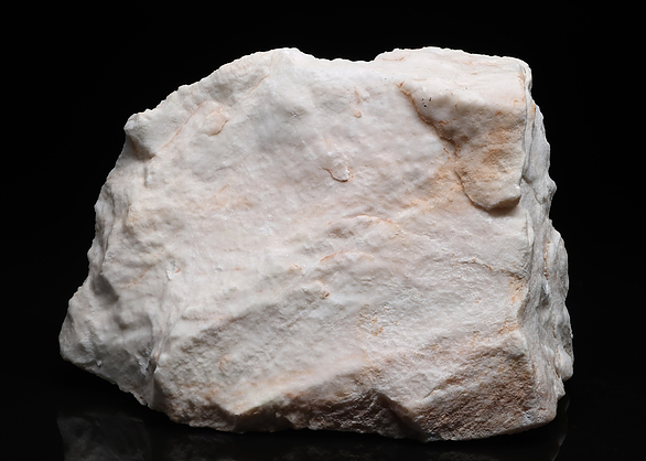


Owl Canyon, Larimer County, Colorado, USA