 | Winter, T.C., Benson, R.D., Engberg, R.A., Wiche, G.J., Emerson, D.G., Crosby, O.A., Miller, J.E. (1984) Synopsis of ground-water and surface-water resources of North Dakota. Open-File Report Vol. 1984 (84-732) US Geological Survey doi:10.3133/ofr84732 | Report (issue) | | GROUND-WATER AND SURFACE-WATER RESOURCES OF NORTH DAKOTA by Thomas C. Winter, Rick D. Benson, Richard...Commission, created "to examine the water needs of North Dakota and propose development alternatives which will...describes the ground waters and surface waters of North Dakota and, importantly, the limitations of existing...technical understanding of the water resources of North Dakota as a basis for decisionmaking with regard to...highlight the complex hydrologic setting of North Dakota and the lack of reliable information on certain |  | | Journal (article/letter/editorial) | | like to report an occurrence of satin spar gypsum, north of La Jolla in San Diego Co., Calif. Take the...National City, Calif. La Jolla, in western San Diego County, is in S / W California. COLORADO — A most attractive...Co., Colorado." Gladstone, in northern San Juan County, is in S / W Colorado. "This specimen represents...and pyrite." West Stafford, in northern Tolland County, is in N / E Connecticut. ILLINOIS — "Enclosed...yellow — both waves. Hamilton, in western Hancock County, is in western Illinois. ROCKS AND MINERALS INDIANA |  | | Journal (article/letter/editorial) | | building stone, road materials, cements, lime, gypsum, clays, etc. Except when the word "comment" expressly...Clays of Economic Value (in North Dakota). First Report BABCOCK, North Dakota Geol. Surv. Pp. 27-55, 3 plates...plates, I90I. The clays of North Dakota are derived from the Pleistocene, the Laramie, and the Fort Pierre...various clay products. Detailed descriptions of North Dakota clays, with analyses and tests, are then given...widely distributed, and plants are in operation at Fargo, Minot, Bismarck, Burlington, Grand Forks, Drayton |  | | Journal (article/letter/editorial) | | Department of Chemistry, North Dakota State University, Fargo, North Dakota 58105 (Received 1 November...SRM 1633b also contained a detectable level of gypsum, which is not common for this type of fly ash....composition and mineralogy (crystalline phases) in North American coal combustion fly ashes is given by McCarthy...representative of the range of compositions of North American fly ashes (Table I). SRM 1633 and 2689...other names of crystalline phases normally found in North American fly ashes. Phase Read peak at 31.1' and |  | | Report (issue) | | Conditions- The Cottonwood Lake Area, East-Central North Dakota Edited by Thomas C. Winter U.S. GEOLOGICAL...complex on the Missouri Coteau in east-central North Dakota. Studies to investigate the relation between.................. Regional Climate of Central North Dakota.................................... Local Climate...FIGURES 1. Map showing Physiographic regions of North Dakota, location of the Cottonwood Lake area, locations...(Map courtesy of Dr. James Arndt, then ofNorth Dakota State University) ............................ |  | | Book | | Minin an Mineral Operations In the \ North- Central States Se es : teat A Wad Lan . Mt Genwo...ei Ey 4 [ MINING AND MINERAL OPERATIONS IN THE NORTH-CENTRAL STATES A VISITOR GUIDE BLM Library Denver...of Mines. Mining and mineral operations in the North-Central States: a visitor guide, by Bureau of Mines...Mid-Atlantic States, the South Atlantic States, the North-Central States, the South-Central States, the Rocky...took place in 1810 near Murphysboro in Jackson County. The first production of natural gas occurred in |  | | Journal (article/letter/editorial) | | BERYL PEGMATITE, BLACK HILLS, SOUTH DAKOTA Walter C. Ackerman South Dakota. School of Mines, Rapid City, S...Black Hills, 25 miles northwest of Pringle, South Dakota, in the vicinity of the Harney Peak batholith....GATE CANYON AND RALSTON CREEK AREAS, JEFFERSON COUNTY, COLORADO John W. Adams U. S. Geological Survey...eight localities in the northern part of Jefferson County, Colorado, in shear zones that cut Precambrian...late Cretaceous-early Tertiary sediments along a north-south line from Fort Peck Reservoir to the Yellowstone |  | | Journal (article/letter/editorial) | | UARY 1919 THE GEOLOGY OF NORTH DAKOTA A. G. LEONARD University of North Dakota, Grand Forks INTRODUCTION...INTRODUCTION The geology of North Dakota is comparatively simple. The geological formations are not as numerous...valley by Paleozoic strata. In going from south to north in the valley the granite has been encountered in...from Fargo, 365 feet; well 7 miles north of Moorhead, 255 feet; Casselton, 20 miles west of Fargo, 455...Grafton, 40 miles north, 903 feet. The well at Rosenfeld, Manitoba, 14 miles north of the international |  | | Journal (article/letter/editorial) | | Photo by author. P ierre Shale outcrops in South Dakota-particularly the Elk Creek location (Roberts and...location maps of the Cedar Creek Anticline, Dawson County, Montana. The anticline is an asymmetric fold...Glendive, Montana, southeast to the Buffalo, South Dakota, area (Davis and Hunt 1956). The earliest faulting...Pierre Shale of the Cedar Creek Anticline, Dawson County, Montana. / transgressive Pierre Shale, in which...baculus, and barren zones of the Pierre Shale, Dawson County, Montana. concretions. Crystal-bearing layers |  | | Report (issue) | | of the agricultural activity in southern Reeves County, Texas. The farthest upgradient spring discharges...basins over 70 km to the west in central Culberson County, Texas. This water then enters and flows through...Phantom Lake Spring Cave in northern Jeff Davis County, Texas and subsequently from the five downgradient...Cave to the five downgradient springs in Reeves County. Beginning in April 2019, NCKRI’s hydrogeologist...been done, but few if any in semi-arid to arid gypsum karst. NCKRI participated in a study to begin to |  | | Journal (article/letter/editorial) | | Department of Geosciences, North Dakota State University, Fargo, ND 58105, USA e-mail: bernhardt.saini-eidukat@ndsu...(Höll et al. 2007). Currently, only China and the USA produce germanium; the former from lignite and Zn–Pb...calcite, smithsonite, cerussite, hydrozincite, gypsum, bassanite, and anglesite dominate the assemblage...Sheffer (1966) analyzed willemites from Franklin, NJ, USA and New Mexico and reported values up to 350 ppm...deposits (Melcher 2003) and at the Apex deposit, UT, USA (Dutrizac et al. 1996). Conclusions Typical sulfide-rich |  | | Report (volume) | | .......................................... The Dakota..................................................the Cimarron Eiver Section from north to south, through Barber County...................................Red rockbuttes, Gypsum Hills....................................... Mansard buttes, Gypsum Hills..........the Dakota strata ....................................... Section on Spring Creek, Meade County .......Harper County ....................... Section down the east side of a small ravine in Harper County ... |  | | Journal (article/letter/editorial) | | of Chemistry and Geology, North Dakota State University, Fargo ND 58105 USA Abstract A strategy for qualitative...same geologic formation (Beulah-Zap, in central North Dakota). Five of the ashes were produced between July...gasification operation in the United States at Beulah, North Dakota. Two specimens from the Department of Energy's...laboratories. Collaborators at the University of North Dakota provided chemical information on the bulk powders...Ettringite Portlandite Gaylussite Thenardite Brucite Gypsum Cristobalite Pyrite Pyrrhotite Ca 3 Mg(SiO 4 ) |  | | Catalog/List | | I PEBBLE PEDDLER 100 NORTH LAKE PARK, BOTTtNEAU, NORTH DAKOTA 68318 Phone: (701) 263-4948 FAX: (701)...desired! $8.00 each! 3 VELVET MALACHITE: Ajo, Plma County, Arizona: 1-2 inch beauties of vibrant green velvet...MARCASITE "SPIKEBALLS": Belle Fouche, Butte County, South Dakota: About the nicest marcasite specimens you...$10.00 eaoh. MOHAWKITE: Mohawk Mine; Keweenaw County. Michigan: From an old collection, this rare c...AURICHALC1TE • 79 MINE: 79 Mine, Bannor District, Gita County, Arizona: Delicate radiating acicular and lathlike |  | | Journal (article/letter/editorial) | | 0 0 0 - 18th Street, Woodward, Oklamhoma 73801. USA M. K. Kilkelly, MS Agronomy Department, Colorado...State University, Fort Collins, Colorado 80523. USA and H. P. Harbert III, MS Central and Southwest...Services. 2700 One Main Place. Dallas. Texas 75250. USA ABSTRACT A high soluble salt content in processed...mining and retorting has been carried out in the USA sporadically for about seventy years, but only at...Commercial oil shale development is now beginning in the USA, but production of enough oil to have an impact on |  | | Report (volume) | | State Museum, Albany. North Carolina.. .Dr. Joseph Hyde Pratt, Chapel Hill. North Dakota... .Dr. A. G. Leonard...Carolina.. .Dr. Earle Sloan, Charleston. South Dakota... .Prof. E. C. Perisho, Vermilion. 6 USEFUL...See Bauxite and Hallpysite. Asbestos. Tallapoosa County, with corundum deposits near Dudleyville; not found...commercial quantity or quality. Asphalt. Colbert County, small quantity has been shipped from near Leighton;...following localities: Bibb County, Pratts Ferry; Calhoun County, near Tampa; Clay County, T. 20, Pv. 7 E.; Jefferson |  | | Catalog/List | | PEBBLE PEDDLER 100 NORTH LAKE PARK BOTTINEAU, NORTH DAKOTA 58318 Phone: (701)263-4948 FAX: (701)263-4544...one, and I’m sure you have all heard about the North Dakota Floods and Blizzards. But that's all behind...AURICHALCITE - BISBEE: Southwest Mine, Cochise County, Bisbee, Arizona: Exceptional baby blue to deep...AURICHALCITE - 79 MINE: 79 Mine, Banner District, Gila County, Arizona: Delicate radiating acicular and lathlike...Morenci Mine, Clifton-Morenci District, Greenlee County, Arizona: Excellent specimens of this great deep |  | | Report (issue) | | Analysis.................................. 15 OK065 North Canadian River geohydrology........... 16 OK068...1985 ground-water and surface-water withdrawals by county......................... Locations of continuous-record.......... Number of water wells measured In each county during winter period......................... ...investigations started. Modeling studies of the the North Canadian River from Oklahoma City to Eufaula Lake...of the Cimarron terrace deposits and the Blaine Gypsum aquifer; a study of the hydraulic and physical |  | | Report (issue) | | Geohydrology of the alluvium and terrace deposits of the North Canadian River from Oklahoma City to Lake Eufaula...geohydrology of the Roubidoux aquifer in Ottawa County, northeastern Oklahoma.................. 18 OK...were greater than or egual to 75 percent of total county withdrawals......................... 4. Location...... 8.--Number of water wells measured in each county during winter period.............................of the atlases describe water conditions in each county in the Panhandle of the State ^nd the other nine |  | | Journal (issue) | | PUBLICATION This guide covers the birds of western North America, with the chain of the Rocky Mountains serving...serving as a convenient natural division of the vast North American continent. Altogether, 508 species are...simply because a conspicuous and thus the easiest to NORTH AMERICAN novice would probably not know the identify...Miller Lake Jeep Trail to Wentworth Springs in the north. Ease of travel within the Wilderness region will...California, just west of the Nevada State line in Mono County, the mining camps of Montgomery City and Blind |  | | Report (volume) | | Okefenokee Swamp. It extends about 38 miles from north to south and is1 about 9.5 miles across at its widest...at only three points, from the west, east, and north. The road to the west entrance leaves U.S. Highway...Highway 441 about half a mile southeast of Fargo, Ga., and terminates 19 miles to the northeast at Camp Stephen...T. 4 N., R. 24 E., Tallahassee Meridian, Nassau County, Fla., about 10 miles east of Camp Cornelia. STRUCTURE...Limestone Cream and gray porous limestone with gypsum in middle part; reef limestone beds in part. 2 |  | | Report (volume) | | Okefenokee Swamp. It extends about 38 miles from north to south and is1 about 9.5 miles across at its widest...at only three points, from the west, east, and north. The road to the west entrance leaves U.S. Highway...Highway 441 about half a mile southeast of Fargo, Ga., and terminates 19 miles to the northeast at Camp Stephen...T. 4 N., R. 24 E., Tallahassee Meridian, Nassau County, Fla., about 10 miles east of Camp Cornelia. STRUCTURE...Limestone Cream and gray porous limestone with gypsum in middle part; reef limestone beds in part. 2 |  | | Report (Issue volume) | | State mineral production and mineral production by county were prepared in the Division of Statistics and...New York Geological Survey. North Carolina: Division of Land Resources, North Carolina Department of Environment...Environment, Health, and Natural Resources. . North Dakota: North Dakota Geological Survey. Oklahoma: Oklahoma...South Carolina Geological Survey. South Dakota: South Dakota Geological Survey. Tennessee: Tennessee... . . . . . . . . . . . . . . . . • • • • • 359 North Carolina, by Steve W. Sikich, P. Albert Carpenter |  | | Report (issue) | | I.—INTRODUCTION Basin of the Red River of the North and of Lake Winnipeg 1 The Glacial Lake Agassi7...Prairies 36 Ascent from the Red River Valley in North Dakota 39 The Manitoba escarpment 40 40 Pembina...DRIFT DEPOSITS Review of the Glacial period in North America The continental ice-sheet Boundaries. Area...Recession of the ice-sheet Latest glaciation far north Glacial currents within the basin of Lake AgassizTable...Basins of the Saskatchewan and the Red River of the North 206 British Columbia, Athabasca, and the Northwest |  | | Report (volume) | | ..... North Carolina. .......................................................... North Dakota.............................:.................... South Dakota..................................................California, Colorado, New Mexico, Oregon, South Dakota, Tennessee, and Texas; to list all the literature...1888. Branner, J. C., The zinc and lead region of north Arkansas: Arkansas Geol. Survey Ann. Kept, for 1892...World's Fair edition, 1904. Genth, F. A., Minerals of North Carolina: U. S. Geol. Survey Bull. 74, 1891. Shannon |
|


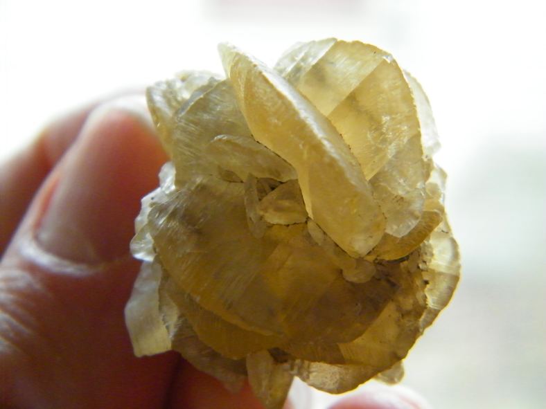

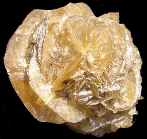


Fargo, Cass County, North Dakota, USA