 | | Report (volume) |
| 582 MINERAL DEPOSITS OF THE SANTA RITA AND PATAGONIA MOUNTAINS ARIZONA BY FRANK C. SCHRADER WITH CONTRIBUTIONS...17 Climate and vegetation. 18 _._ History of mining and present conditions___________________ 20 ...__ ______-_____________ Mountains _ __________ _ Santa Rita and Patagonia ranges ______ _ Empire Mountains...___ Valleys ___________'__-_________________ Santa Cruz Valley-________________ __ Cienega Valley___..._______________ . Placers __ _ Mineralogy ____________ Mining districts, camps, and properties. Helvetia district_ |
 | | Report (issue) |
| Preliminary report of molybdenum occurrences in Arizona by Jan C. Wilt 1/, Stanley B. Keith 2/, Jocelyn...to the Arizona Bureau of Geology and Mineral Technology a division of The University of Arizona This...'1030571 04 M030562 04 M030563 04 '1030584 04 CouNTY DEPosir 'ostHP +litire LAtiroOE ♦ Looroae 28N... wA A 7 PROSPECT 15N 02E 27 MU AMOLE DISTRICT BANNER DISTRICT BLUE HELL GROUP 19N 215W 101 35-03-A wA...CUA AG BORIANA MINE 18N 115W 118 34-56-154 113-54-53W CATALINA DISTRICT CATALINA DISTRICT CHILDS-ALOWINKLE |
 | | Report (volume) |
| ........................................ 10 Arizona......................................................................................... 102 District of Columbia ....................................to refer to Geological Survey Bulletin 507, "The mining districts of the western United States," and to...abundant it may have been completely exhausted by mining or quarrying. Deposits of minerals that are widely...because they occur in sufficient quantity to warrant mining for their usual products, but because they furnish |
 | | Book (volume) |
| ...........................................13 Arizona ................................................................548 Table of Maps Page Alabama County Map ...................................................................................4 Alaska County and Stream Map ...................................................................14 Arizona – Apache Co. Mining Districts ...............................................................22 Arizona County Map ............................................ |
 | | Report (issue) |
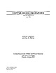
| Phillips Arizona Department of Mines and Mineral Resourses 1502 West Washington Phoenix, Arizona 85007 .... . 1 Arizona Copper Deposits 1 Figure 1. Map showing copper oxide resources in Arizona 2 Figures...3 Table 1. Arizona copper oxide deposits Cochise County . Coconino County 4 6 Gila County . . . . ....Graham County . . 7 Greenlee County 8 La Paz County. . . 8 Maricopa County 9 Mohave County · 10...10 Navajo County Pima County. . · 11 Yavapai County .. · 11 . . . . 13 . . . . .. . 16 16 Yuma County |
 | | Book (volume) |
| ...........................................11 Arizona .................................................rights, so remember you were told. If in doubt, a county map will tell you who the legal owner is. Good...gemmy qualities for cutting and polishing. AUTAUGA COUNTY PRATTVILLE, N. 6 mi., and just E of the Birmingham...were well known to prehistoric Indians.) BARBOUR COUNTY BAKER HILL, SE 1 mi. : 1 in a deep ravine, as a...deep red to variegated⎯ocher. BIBB COUNTY GENERAL AREA: c county gravel pits along the Cahaba R.⎯gemmy |
 | | Report (issue) |
| OF AMERICA ARIZONA 1986 THE NATIONAL GAZETTEER OF THE UNITED STATES OF AMERICA ARIZONA 1986 FRONTISPIECE...reflects the Spanish and native American heritages of Arizona. The name honors the Jesuit missionary Saint Francis...of America. Arizona 1986. (U.S. Geological Survey professional paper ; 1200-AZ) 1. Arizona Gazetteers...Alphabetical list of Geological Survey maps of Arizona.......................................................................................... xiii Arizona .............................................. |
 | | Book (volume) |
| Wyoming VOLUME 4: THE SOUTHWESTERN QUADRANT Arizona, Arkansas, California, Colorado, Louisiana, Nevada...Abbreviations and Mineral Location Numbers Arizona Arkansas California Colorado 258 Louis B30...volumes, through very precise directions and accurate county maps, to get you to the best and most accessible...for the county in which it is located. This site number also appears under the given county in the text...gravel pit, prospect, mine, etc.). Let’s take, as an example, under the heading of Arizona, on the map of Maricopa |
 | | Book |
| Rock-Hunter's Range Guide Petrified Forest Trails Arizona Gem Trails and the Colorado Desert of California...Minerals in L.\merica Alabama Alaska Arkansas Arizona California Colorado Connecticut Delaware Florida...of commercial mining is also long, beginning with the Kenya opal mines of 4000 B.C. Mining began with gemstones...gemstones, instead of metallic ores, and mining for turquoise was enormously extended throughout the...had been sending great expeditions to prospect and mine for it throughout the Sinai Peninsula since at least |
 | | Book (edition) |
| describes sites under of the nearest town and county. and the many maps included book contain such... Sapphire O Quartz crystal ^J^ Garnet __ Azurite, Malachite, Chrysocolla, Turquoise LJ Emerald...of Butte, Montana, Walter Wright of the Prospectors Shop and Herbert Grand Girard, both of Santa Fe,...as a means of identification. For some, such as azurite or malachite, the color is a primary characteristic...distinguished from (manganese silicate). Malachite and azurite are rhodonite also carbonates. Apatite, a phosphate |
 | | Book |
| P. Blake, professor of mineralogy, geology and mining at the College of California, parent to the University...California, and published in the fourth and sixth State Mining Bureau reports. Then beginning in 1914 with a volume...are reported by county of occurrence. Map 1-2 shows the county boundaries and county names. When possible...,o Map 1-2. Outline map of California showing county boundaries. __ _) 4 MINERALS OF CALIFORNIA...composition between acidic and basic rocks. drift mine Adit(s) driven into gravel. euhedral Characterized |
| | Book |
| P. Blake, professor of mineralogy, geology and mining the at College of California, parent to the...mineralogist of California, and pub- and sixth State Mining Bureau reports. Then beginning volume prepared...species are reported by 1-2 shows the county boundaries and county names. When possible, locations of mines...within a township is illustrated by Figure 1-1. county of occurrence. Map *M. Fleischer’s 1980 Glossary...Map 1-2. Outline map of California showing county boundaries. 4 MINERALS OF CALIFORNIA R5W i |
 | | Report (issue) |
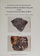
| paralle l to host-rock bedding. Black Cloud mine, Leadville district. Sherman-type ore (bottom) in paleokarst...veined with ferroan dolomite. rv1oose mine, North Alma district. Photographs b)' \Villiarn Sacco, Peabody...Carbonate-hosted sulfide deposits of the central Colorado mine ral belt: Introduction, general discussion, and...Johansing Leadville district: Geology and the origin of ore deposits in the Leadville district, Colorado: Part...and the origin of ore deposits in the Leadville district, Colorado: Part II. Oxygen, hydroge n, carbon |
 | | Book (edition) |
| MARIN COUNTY FREE LIBRARY 3 1111 00289 4184 \ I s Fifth Revised Edition A complete, state-by-state...desert of California and the Sonoran desert of Arizona, the lake beaches of the Middle West, the broad...AND HABITS rfgk -tI I I 3 ^$7 "c APATITE AZURITE BERYL CHIASTOLITE L_V FELDSPAR EMERALD (orthoclote)...as a means of identification. For some, such as azurite or malachite, color is a primary characteristic...rhodonite (manganese silicate). Malachite and azurite are also carbonates. Apatite, a phosphate, can |
 | | Journal (issue) |
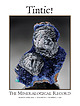
| KRISTALLE Est.1971 Laguna Beach, California, USA • Tel: +1 949 494 5155 • Email: info@kristalle.com... Gressman tom.gressman@minrec.org The Tintic District: Juab and Utah Counties, Utah...................COVER: CLINOCLASE, 3.9 cm, from the Mammoth mine, Tintic District, Utah. Rock Currier collection; Jeff Scovil...sample of a pascoite group mineral at a mine in Grand County, Utah. Died, Alex Earl, 26 Jayson Alexander...over the American West. A trip to the Blue Bell mine near Baker, California, in 2016 was particularly |
 | | Book (volume) |
| Executive Director The Bowers Museum of Cultural Art Santa Ana, California + GEMSTONES OF EAST AFRICA by Peter...(25.56 ct), Sweet Home Mine, Colorado; colorless scheelite (19.66 ct), Kern County, California; octagonal...Vivid blue matched benitoite gems from San Benito County, California, consisting of 52 benitoites and 75...Harold Van Pelt & GEOSCIENCE PRESS, INC. Tucson, Arizona © 1997 by John Sinkankas Library of Congress...events to bring the history of North American gem mining up to date. Here, then, is the latest, most complete |
 | | Book |
| HfiRIN COUNTY FREE LIBRfiRY 311110G386652Q I V Russell P MacFal A COLOR TREASUF FOR COLLECTORS...it a veritable not just a picof informa- is mine tion, telling everything the collector needs to...to Hunting Locations ? i 9 GIVEN TO THE MARIN COUNTY LIBRARY BY MARI N L MTNF.RAT. SOCTETY DAVID...can use a mountaineering bag or a mili- quarry or mine where a permit tary bag; make it it should...may be able to buy specimens. map of Keweenaw County. Mich- Part of the U.S. Geological Survey topographic |
 | | Book (volume) |
| 5 = fii? i a j — » ya y _— ’* : i mine in. q)! Y eit iia -...Furcron, Chief Geologist of the Department of Mines, Mining and Geology; on the State of Michigan by Robert...amethyst deposit in Arizona by Dr. F. W. Galbraith of the University of Arizona. Robert O. Vernon of...deposits was given by G. Keith Hodson of Scottsdale, Arizona. A similar service in the case of the vil Vill...Kobuk jade locality. Descriptions of San Diego County, California, gemstones and the mines in which they |
 | | Report (issue) |
| The Elk Range thrust zone ......... ...... The Castle Creek fault zone ........ ...... Other faults ............. Photographs showing features of the Castle Creek fault zone ................................Photograph showing setting of the Pitkin Iron Corp. mine ..................................................silver-bearing copper sulfides from the Snowmass Creek mine................................ 14. Analyses of...the Sawatch uplift, the Elk Range thrust, and the Castle Creek fault zone. Early in the rise of the Sawatch |
 | | Book (edition) |
| (botryoidal) masses or coatings; usually found with azurite; hardness 3.5—4; sp. gr. 3.9-4.0. important ores...es Oks Cu2CO3(OH)2 malachite outside crusty AZURITE MALACHITE Emerald green (deep azure blue) -...brittle. tr. ck acess aa on PUI ES Cuz (OH)2(CO3)2 azurite 57a. Usually found in fibrous masses or granular...in white natrolite in serpentine in San Benito County. Hardness 6—6.5. calaverite AuTe2 appears as deeply...after many centuries of erosion or by deep rock mining. Other minerals, such as cinnabar (the ore of mercury) |
 | | Report (volume) |
| so successful. Allis-Chalmers Manufacturing Co. Mining Machinery Dept. OFFICES For Canadian MILWAUKEE...Canada THE MINES HANDBOOK Meeting tbe Needs of Mine and Smelter Hundreds of plants on both American...service from Superior Jaw Crusher Worthington mining equipment the from the standpoint of first cost...most wear, Worthington meets the needs of the mining industries with a complete line of products, from...(all types) Crushers Crushing Rolls NEW YORK Mine Pumps Oil Engines Sampling Machinery Screens Stamp |
 | | Report (volume) |
| California. THE MINES HANDBOOK, 1922 MACHINERY FOR MINE • MILL SMELTER Embodying recent developments...Hydraulic TurbinpM MILWAUKEE, Metallurgical Machinery Mining Machinery Perforated Oil l-:imini-- Metals I'liiiiliini:...are getting the most in service from Worthington mining equipment — :the most from the standpoint of first...power consumption. Worthington meets needs of the mining industries with a complete line of products, from...Compressor NEW YORK Crushing Rolls Air Compressors Mine Pumps Ball Mills Blast Furnaces Oil Engines Screens |
 | | Journal (issue) |
| Gustave Baumann, Santa Fe artist, at Museum of Northern Arizona, Flagstaff, Arizona. July 27-Aug. 6^Carbon...6^Carbon County Centennial prografn, Price, Utah. July 31-Aug. 1-2—11th Annual Robbers' Roost Roundup,...iNew Mexico. Aug. 1-3—Flagstaff rodeo, Flagstaff, Arizona. Aug. 2—Annual fiesta and dance, Jemez Pueblo,...of Arizona photographers, with emphasis on the Southwestern scene, at Museum of Northern Arizona, Flagstaff...Prescott, Arizona. Aug. 10—San Lorenzo day, Summer Corn dance, Picuris Pueblo, New Mexico. Aug. 12—Santa Clara |
 | | Journal (volume) |
| Geologist C. A. Logan, District Mining Engineer C. McK. Laizure, District W. Burling Tucker, Reid...Francisco - District Sampson, Assistant Mining Engineer District Engineer Chas. V. Averill, District Mining...San Francisco Mining Engineer -•-'-- and Curator Herbert A. Franke, Junior Mining Engineer (Librarian)...San Francisco TABLE OF CONTENTS REPORTS OF DISTRICT MINING ENGINEERS Page 1 Sacramento Field Division...GIST CALIFORNIA — O * LEGEND* Mining Division Bou/icfar/es. Mining Division Off/ces. MEXICO PREFACE |


