 | | Report (issue) | | Belt on the East Side of the Cincinnati Arch in Kentucky, With Revisions in the Nomenclature GEOLOGICAL...Belt on the East Side of the Cincinnati Arch in Kentucky, With Revisions in the Nomenclature By ROBERT...OF KENTUCKY GEOLOGICAL SURVEY PROFESSIONAL PAPER 1151-F Prepared in cooperation with the Kentucky Geological...of the Cincinnati Arch in Kentucky. (Contributions to the geology of Kentucky) (Geological Survey professional...2. Geology, Stratigraphic Nomenclature Kentucky. I. Kentucky Geological Survey. II. Title. III. Series |  | | Journal (article/letter/editorial) | | Sphalerite IN BATH COUNTY, CENTRAL KENTUCKY WILLIAM J. SCHAUB 1908 Blairmore Road Lexington, Kentucky 40502 Figure...been found at a conspicuous location in central Kentucky. Although numerous, the vugs are so small that...series of road cuts along Interstate 64 near Owingsville, Kentucky, approximately 40 miles east of Lexington...exposed along the Cincinnati Arch throughout central Kentucky. At this locality, mineralized vugs occur in the...5 feet containing numerous irregular lenses of chert. The Drakes Formation grades into the underlying |  | | Report (issue) | | valley the "Red Mountain" shows the Fort Payne chert along its southeastern face, while the Rockwood...of Fort Payne furnace, Alabama. Feet. Fort Payne chert. Chattanooga shale................................ THE IRON ORES OF BATH COUNTY, KY.« By E. M. KINDLE. Introduction. Bath County is located in the northeastern...of the bold, hilly type characteristic of the Kentucky mountain districts. Rugged, steep-sided hills...which comprises the northwestern two-thirds of the county. The deeply incised and widely meandering channel |  | | Journal (article/letter/editorial) | | Kentucky Kentucky Mineral Mineral Locality Index Downloaded by [Dalhousie University] at 18:01 27 December...Caldwell Stone Company quarry, Danville, Boyle County. Terry Huizing specimen and photo. K entucky...Commonwealth is Black Mountain in the Appalachians (Harlan County) at 4,139 feet. The lowest point is the floor of...quarry near Grand Rivers (Livingston County) in western Kentucky, at 100 feet below sea level. There are...nondiamondiferous kimberlite in Elliott County in eastern Kentucky and alnöite intrusions in Crittenden |  | | Report (issue) | | Lithostratigraphy of Upper Ordovician Strata Exposed in Kentucky U.S. GEOLOGICAL SURVEY PROFESSIONAL PAPER 11.51-E...cooperation with the Commonwealth of Kentucky, University of Kentucky., Kentucky Geological Survey Lithostratigraphy... Lithostratigraphy of Upper Ordovician Strata Exposed in Kentucky By G. W. WEIR, W. L. PETERSON, and W C SWADLEY...U.S. GEOLOGICAL TO THE SURVEY GEOLOGY OF KENTUCKY PROFESSIONAL PAPER 1151-E Prepared in cooperation...cooperation with the Commonwealth of Kentucky, University of Kentucky, Kentucky Geological Survey Descriptions |  | | Report (issue) | | section in Madison County, Ky., north-northeastward to locality IO in Adams County, Ohio, showing relationships...outcrop belt around the Cincinnati Arch in Indiana, Kentucky, and Ohio. Thirty-four indigenous species r epresent...overlie the Brassfield from Jefferson County, Ind., into Bullitt County, Ky., possibly should be placed within...the type area than in the type area of central Kentucky. From about 5 miles southeast of Stanford, Ky...Ky., northeastward to northern Adams County, Ohio, the Brassfield Formation is overlain conformably or |  | | Report (volume) | | Black. (F) The Reany Creek Formation, Marquette County, Michigan, by Willard P. Puffett. (G) The Aguada...Formation in the southeastern Kaiparowits region, Kane County, Utah, by Fred Peterson. (K) Summary of Cretaceous...Paleozoic formations of the Mountain City area, Elko County, Nevada, by R. R. Coats________________________________________...City and Owyhee quadrangles, Elko County, Nev., and Owyhee County, Idaho_____ __ 2. Kodiak and adjacent...1967.) central Kentucky._..._--...- In central Kentucky, from Richmond north to Owingsville, the Gilbert |  | | Book (volume) | | Dahlonega Co. and Rabum Co., and the McDuffie County Belt extending through portions of McDuffie, Warren...Sphalerite. BALDWIN COUNTY MILLEDGEVILLE, at state farmjasper. BANKS COUNTY COMMERCE, along Hwy. 59...along adjoining Co. linerock crystal. BARROW COUNTY WINDER, along rd. to Jefferson and 1½ mi. inside...Guide for Rock Hounds in the United States BARTOW COUNTY AREA, Saltpeter Cave, as floatjasper. CARTERSVILLE:...agate, (banded, various colors), jasper. BIBB COUNTY MACON: at Holton Quarry, 7½ mi. NWagate; N |  | | Report (issue) | | and rodingite in Hunting Hill quarry, Montgomery County, Md. A summary, by D. M. Larrabee. _______ Accessory...________-_--_____-A temperature-controlled water bath for mineral solubility studies, by P. B. Hostetler...ages of some igneous rocks in northern Stevens County, Wash., by R. G. Yates and J. C. Engel~_____- ...KANSAS FINNEY COUNTY 1 HAMILTON COUNTY ' | *-L^ | KEAKNY COUNTY STANTON COUNTY GRANT COUNTY Area of B...B map N j Garden HASKELL COUNTY FIGURE 1. Area of report in dune area (patterned) south of the Arkansas |  | | Book (volume) | | 600 to 800 feet thick in the north. ALEXANDER COUNTY FAYVILLE, area stream gravels⎯agate, jasper, rare...⎯agate, jasper; d RR siding of Clay⎯agate. CALHOUN COUNTY AREA, shores of the Mississippi R., in the Warsaw...crystals). CRAWFORD COUNTY PALESTINE, area deposits⎯Siderite. EDWARDS COUNTY AREA, T. 1 S, R. 10 E...E, regional deposits⎯Siderite. FULTON COUNTY FARMINGTON, W 6 mi. on Rte. 116 to the Rapatee No. 5 strip...mine⎯pyritized gastropods (Pennsylvanian age). GRUNDY COUNTY AREA: c Regional rd. and RR cuts and banks of Mason |  | | Book (volume) | | 600 to 800 feet thick in the north. ALEXANDER COUNTY FAYVILLE, area stream gravels⎯agate, jasper, rare...⎯agate, jasper; d RR siding of Clay⎯agate. CALHOUN COUNTY AREA, shores of the Mississippi R., in the Warsaw...crystals). CRAWFORD COUNTY PALESTINE, area deposits⎯Siderite. EDWARDS COUNTY AREA, T. 1 S, R. 10 E...E, regional deposits⎯Siderite. FULTON COUNTY FARMINGTON, W 6 mi. on Rte. 116 to the Rapatee No. 5 strip...mine⎯pyritized gastropods (Pennsylvanian age). GRUNDY COUNTY AREA: c Regional rd. and RR cuts and banks of Mason |  | | Report (issue) | | SURVEY TECTONIC EVOLUTION IN CENTRAL AND EASTERN KENTUCKY: A MULTIDISCIPLINARY STUDY OF SURFACE AND SUBSURFACE...Report 89-106 Work done in cooperation with the Kentucky Geological Survey State Geologists: Wallace W...AT CAMP NELSON, KENTUCKY ABSTRACT Geological and geophysical mapping of Kentucky between 82 and 86...north of this area where the original scarp of the Kentucky River Fault, bounded by Precambrian, Cambrian... If ancient counterparts of the Brumfield and Kentucky River Fault Systems were once coextensive a total |  | | Report (volume) | | Erasmus Haworth, University of Kansas, Lawrence. Kentucky........Mr. J. B. Hoeing, Frankfort. Mr. J. H....See Bauxite and Hallpysite. Asbestos. Tallapoosa County, with corundum deposits near Dudleyville; not found...commercial quantity or quality. Asphalt. Colbert County, small quantity has been shipped from near Leighton;...following localities: Bibb County, Pratts Ferry; Calhoun County, near Tampa; Clay County, T. 20, Pv. 7 E.; Jefferson...Jefferson County, at Elyton; Lee County, at Chewacla lime works; St. Clair County, at Gfeensport; Shelby |  | | Report (volume) | | ....................................... 135 Kentucky.................................................See Bauxite and Halloysite. Asbestos. Tallapoosa County, with corundum deposits near Dudleyville; not found...commercial quantity or quality. Asphalt. Colbert County, small quantity has been shipped from near Leighton;...following localities : Bibb County, Pratts Ferry; Calhoun County, near Tampa; Clay County, T. 20 S., R. 7 E.;...; Jefferson County, at Ely ton; Lee County, at Chewacla lime works"; St. Clair County, at Greensport; |  | | Report (issue) | | FISHERIES RESEARCH The Ordovician Paleontology of Kentucky and Nearby States-Introduction LAB LIBRARY The...Brachiopods Additional Trilobites From the Ordovician of Kentucky Edrioasteroids (Echinodermata) Asteroidea (Echinodermata)...cooperation with the Commonwealth of Kentucky, University of Kentucky, Kentucky Geological Survey Contributions... Contributions. to the Ordovician PaleontOlogy of Kentucky and Nearby States . Edited by.John Pojet~, Jr. A. ... The Ordovician Paleontology of Kentucky and Nearby StatesIntroduction, by John Pojeta, Jr. B. The Brachiop~d |  | | Report (issue) | | relative amounts of clastic quartz (in ironstone) or chert (in iron-formation). Data on minor-element content...sedimentary rocks sandstone, shale, limestone, chert with retention of attributes of the parent stem...in which rocks it is interbedded with quartz ("chert"). MAQHEMITE (y-FeiOs) Maghemite, the strongly...commonly occurs as impure layers alternating with chert (quartz); magnetite-bearing itabirite of Brazil...large part composed of interbedded siderite and chert. Analyses of six sedimentary siderites are given |  | | Report (volume) | | Southeastern Missouri, southern Illinois, and western Kentucky. J. S. Templeton and H. B. Willman, 1963, Illinois...74, Ph miles east of Dutchtown, Cape Girardeau County, Mo. Type section cut by northtrending fault with...stream in NEIA sec. 33, T. 16 N., R. 14 E, Wayne County. Named after village of Abington, about 3 miles...STATES Clasts are red and green andesites and some chert. Interbedded with red conglomerate are green tuffaceous...including shale and siltstone, dolomitic sandstone, chert, and limestone. West of Adam Peak, where section |  | | Book (edition) | | mmed at Broken Arrow aud Trout creek, in Sc. Clair county. The strata in this field are more faulted und...prong of Canoe creek, in St. Clair county, to Ha\sop creek, in Bibb county, a distance of 60 miles. Down to...to Helena, in Shelby county, the field has an average width of 5 or 6 miles. Below that point the width...miles being in the latitud" of Blocton, in Bibb county. The south ern end of this field has a greater...Jefferson county; Helena, Montevallo, and Brierfield, Shelby county; and at Blocion. Bibb county. The Warrior |  | | Book | | Georgia Hawaii Idaho Illinois Indiana Iowa Kansas Kentucky Louisiana Maine Maryland Massachusetts Michigan...family minerals ( agate, carnelian, chalcedony, chert, flint, jasp-agate, jasper, quartzite, rock crystal...listed by county and community, range and distance. Whenever the collector crosses a county line, he will...of the county he is entering posted alongside the highway. By looking up the state and county, the user...guide can determine the collecting sites in that county by range and distance from the major cities and |  | | Book | | 4 ‘ » deat oggrtniLhy fiih ors! ¥; The Kentucky Geological Survey “=| WILLARD ROUSE JILLSON! ...Geology: and Mineral Resources of Kentucky 1928 Western Kentucky Fluorite— Ca F, 2 Natural Size The... The GEOLOGY and MINERAL RESOURCES of KENTUCKY A Brief Description of the Physiography, Stratigraphy,...GEOLOGIST OF KENTUCKY, CURATOR OF THE STATE MUSEUM AND LECTURER IN GEOLOGY AT THE UNIVERSITY OF KENTUCKY Illustrated...Fifty-one Photographs, Maps and Diagrams THE KENTUCKY GEOLOGICAL FRANKFORT, 1928 KY. SURVEY FIRST |  | | Report (issue) | | ----------- 29 Illinois and Kentucky ----------------------- 30 Kentucky ----------------------------------...Georgia ------------------------------------ 78 Kentucky ---------------------------------- 79 Mississippi...cooperators ----------------------------State, county, and local cooperators -------------Other cooperators... 4. 5. Published geologic quadrangle maps of Kentucky as of May 1, 1974 ----------------------------------...the Brooks Spring 71;2-min quadrangle, Humboldt County, Nev., has revealed numerous areas that contain |  | | Book (edition) | | illustrating the intimate re lations of ore and chert. After F. Nicholson 213 Xviii LIST OF ILLUSTRATIONS...and Ohio we find a rolling, hilly country; in Kentucky and Tennessee, elevated tableland, with deeply...for the mines of the Summit district, Rio Grande County, Colorado.8 Alkaline solutions remove silica and...alternating ruby silver ores and quartz. Those of Gilpin County, Colorado (Example I7a), afford alternations of...Butte, Mont. (Example 17), and others in Llano County, Texas (Example 17ft), may be cited. At Ducktown |  | | Book | | commercial ores and secondary minerals by state, county, township, and geologic range. For easy identification...cities, and many of today’s prosperous western county seats began as mining-boom camps. trating sand...Whether you such as those listed alphabetically by county, township, and range in Part II of this book. Where...Siliceous sediments: Siliceous sinter (geyserite), chert, flint, etc. Iron ore precipitates: Ferrous carbonate...will help you prospect and explore any state and county. etc., for mineral deposits in Finding Suitable |  | | Journal (issue) | | valuable ores in the vicinity of Albion, Pushmataha county, Oklahoma, some finds being reported as exceeding...of the land. The rocks in the region consist of chert, shale and sandstone, carrying here and there small...extinguished. Socialists propose that the nation, state .county and city acquire the ownership of public utilities...Denver Bonanza . Sat 15 Ouray Tues 6 Pitkin County . 43 Pueblo S. Union Tues Sat 36 Rico John Kneisler...74 National Mine Lorence Verbos 1-3 Oaney Owingsville John Kivimaki H. B. Snellman. John E. Auttila |  | | Report (issue) | | A253-A258 of this chapter. Numerous Federal, State, county, and municipal agencies and other organizations...----Missouri.. _ _____________-_------_-----_ Kentucky....________________.__.Tennessee. _ _________...cooperators_-____ ---------_____-____ 209 State, county, and municipal cooperaters__________ 209 Other...silver-gold mining district in northwestern Elko County, has revealed evidence leading to a revision of...Gold Butte in the southern Virgin Mountains, Clark County, Nev., to the Gold Basin-Lost Basin district south |
|
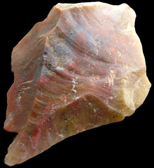


Owingsville, Bath County, Kentucky, USA