 | | Report (issue) |
| Quadrangle, Colorado GEOLOGICAL SURVEY PROFESSIONAL Prepared in cooperation with the Colorado State Geological...Geological Survey Board and the Colorado Metal Mining Fund PAPER 289 Geology and Ore Deposits of...of the Garfield Quadrangle, Colorado By McCLELLAND G. DINGS and CHARLES S. ROBINSON GEOLOGICAL SURVEY...in cooperation with the Colorado State Geological Survey Board and the Colorado Metal Mitting Fund. A..._ Fremont dolomite _________________________ _ Chaffee formation __________________________ _ Leadville |
 | | Report (issue) |
| Oxidized Zinc Deposits of the United States Part 3. Colorado By ALLEN V. HEYL GEOLOGICAL SURVEY BULLETIN...deposits and the resources of oxidized zin.c ores in Colorado UNITED STATES· GOVERNMENT PRINTING OFFICE, WASHINGTON...19180xidized zinc deposits of the United States. Part 3. Colorado. Washington, U.S. Govt. Print. Off., 1964. vi...Bibliography : p. 88-91. 1. Zinc ores-Colorado. 2. Zinc mines and mining-Colorado. I. Title. (Series) For sale...__ ___ __ __ __ __ __ _____ Kokomo (Ten ~ile) district _______ ._________________________ Breckenridge |
 | | Report (volume) |
| Minerals of Colorado: A 100- Year Record By EDWIN B. ECKEL GEOLOGICAL SURVEY BULLETIN 1 1 14 A...knowledge____________________________________ Future of Colorado mineralogy______________________________________...mineral localities and metallic mineral deposits of Colorado ________________________________ In pocket III...mineral localities and metallic mineral deposits of Colorado, has not been included in this reprint. Many of...especially Fischer and others, 1946). MINERALS OF COLORADO: A 100-YEAR RECORD By EDWIN B. EcKEL ABSTRACT |
 | | Book |
| MINES AND MINERALS OF THE GREAT AMERICAN RIFT (COLORADO-NEW MEXICO) Sine —_—< ¢ te om At _SHT 40...MINES AND MINERALS OF THE GREAT AMERICAN RIFT (COLORADO-NEW MEXICO) Richard Walker Holmes and Marrianna...Mines and minerals of the Great American Rift (Colorado-New Mexico). Bibliography: p. Includes index...index. 1. Mines and mineral resources—Colorado. 2. Mines and mineral resources—New Mexico. I. Kennedy, Marrianna...enter must be obtained to prevent trespass. Old mine workings are dangerous and entering underground |
 | | Report (issue) |
| ___________ ____ __ ________ ____ Silver Islet district ___________________ ~_____________________ Cache..._______________________________ American Fork district (Alta area)___________________________ Alpine...______ Redmond district __________________________________ _:________ Millard County _______________...Map showing oxidized ziuc deposits of the Tintic district, Juab and Utah Counties. 3. Map showing oxidized...the Star district, Beaver County. 5. Map showing oxidized zinc deposits in the Park City district, Summit |
 | | Report (issue) |
| . . . . . . . . . . . . . . . . . 1 Chapter I. Mining Districts of Counties and the State of Utah. .... . . . . . . . . . . . . . . . . . . . . . . 1 County Listings. . . . . . . . . . . . . . . . . . . ... . . . . . . . . . . . . . . . . 1 Chapter II. Mining Districts of Utah . . . . . . . . . . . . . . .... . . . . . . . 4 Mineral Localities Listed by County . . . . . . . . . . . . . . . . . . . . . . . .... . . . . . . . . . . . . . . . . . . 7 Beaver County . . . . . . . . . . . . . . . . . . . . . . . |
 | | Report (volume) |
| it helpful to refer to Survey Bulletin 507, "The mining districts of the western United States," and to...abundant, it may have been completely exhausted by mining or quarrying. Deposits of minerals of wide distribution...because they occur in sufficient quantity to warrant mining for their usual products but because they furnish...A. F. Rogers, Stanford University, Palo Alto. Colorado.........Prof. R. D. George, Boulder. Connecticut...See Bauxite and Hallpysite. Asbestos. Tallapoosa County, with corundum deposits near Dudleyville; not found |
 | | Report (issue) |
| prospects of the Tyrone stock and vicinity, Grant County, New Mexico By D. C. Hedlund 1 Open-File Report...standards and stratigraphic nomenclature. Denver, Colorado CONTENTS Page Abstract.......................of the quartz-pyrite veins of the White Signal district............................... Quartz-molybdenite.... Quartz-pyrite veins, including White Signal district............... Silver-lead-manganese oxide veins...prospects of the Tyrone stock and vicinity, Grant County, New Mexico.......................... in pocket |
 | | Report (volume) |
| ............................................. Colorado........................................................................................ 102 District of Columbia ....................................to refer to Geological Survey Bulletin 507, "The mining districts of the western United States," and to...abundant it may have been completely exhausted by mining or quarrying. Deposits of minerals that are widely...because they occur in sufficient quantity to warrant mining for their usual products, but because they furnish |
 | | Journal (issue) |
| PHOTOGRAPHY Pictures of the Month LOST MINE Lost Desert Q u e e n Mine, b y W. R. HILLERY . 17 . LIARS...26 NEWS From Here and There on the Desert 28 MINING Current n e w s of desert mines 33 HOBBY G...delightful spot. Major John Wesley Powell and his Colorado River exwithin the Monument. plorers spent three...heart of a mile long . . . The river has worn the Colorado desert wilderness, and the out hollow domes in...the Colorado River Compact of 1922 had allotted 7,500,000 acre feet of stream flow in the Colorado River |
 | | Report (issue) |
| GEOLOGICAL SURVEY Locatable Mineral Reports for Colorado, South Dakota, and Wyoming provided to the U.S.............................................. 1 COLORADO ..................................................... . . ............ 10 Pike National Forest County of El Paso (Black Forest) Land Exchange Offer ...Exchange Offer ................... 221 FIGURES COLORADO Arapaho and Roosevelt National Forests Pawnee...................... 48 Fig. 14. Map 12-Offered mining claims-Quartz Creek & Cumberland Pass areas (provided |
 | Morris, H.T., Lovering, Thomas Seward, Mogensen, A.P., Shepard, W.M., Perry, L.I., Smith, S.M. (1979) General geology and mines of the East Tintic mining district, Utah and Juab counties, Utah, with sections on the geology of the Burgin mine and the geology of the Trixie mine. Professional Paper 1024. US Geological Survey doi:10.3133/pp1024 | Report (issue) |
| General Geology and Mines of the East Tintic Mining District, Utah and Juab Counties, Utah GEOLOGICAL SURVEY...General Geology and Mines of the East Tintic: Mining District, Utah and juab Counties, Utah By H. T. MORRIS...LOVERING With sections on THE GEOLOGY OF THE BURGIN MINE By A. PAUL MOGENSEN, W. M. SHEPARD, H. T. MORRIS... and S. M. SMITH and THE GEOLOGY OF THE TRIXIE MINE By A. PAUL MOGENSEN, H. T. MORRIS, and S. M. SMITH...highly productive silver, gold, and base-metal mining district in the east-central Great Basin UNITED STATES |
 | | Report (issue) |
| description of the geology, mining history, and production of the major gold-mining districts in 21 States...relations ---------------------------History of gold mining and trends in production_ J\labama -----------...--------------Cleburne County ----------~----------------- Tallapoosa County --------------------------Alaska...------------------Cochise County -----------------------------Gila County --------------------------------Greenlee...ee County ----------------------------R[aricopa County ----------------------------R[ohave County -- |
 | | Book (volume) |
| instance, a single Spodumene crystal from the Etta Mine near Keystone on the east side of the Mount Rushmore...beds, excavations, etc.Selenite roses. BRULE COUNTY AREA: in the Oacoma zone of the Pierre Fm. On Elm...gray Barite rosette up to 5 or 6 inches. CAMPBELL COUNTY MOUND CITY, W to the Missouri R., regional hillsides...gravels, etc.petrified wood, wood opal. CORSON COUNTY LITTLE EAGLE: area ridges, slopes, stream beds...Hounds in the United States CUSTER COUNTY AREA: The November Mine, 1.2 mi. SE of the Needles Eye Tunnel |
 | | Report (issue) |
| Bldg., 2600 corridor, 18th and CSts.,NW. DENVER, Colorado-Federal Bldg., Rm. 169,1961 Stout St. LOS ANGELES...ROLLA, Missouri-1400 Independence Rd. DENVER, Colorado-Map Distribution, Bldg. 810, Federal Center FAIRBANKS...Replacement Deposits Part II Gold in the Tintic Mining District, Utah By HALT. MORRIS Gold Deposits in the...Bird Mining Districts, San Juan Mountains, Colorado By FREDERICKS. FISHER Gold in the Alma Mining District...District, Colorado By DANIEL R. SHAWE Precious Metals in the Leadville Mining District, Colorado By TOMMY |
 | | Report (issue) |
| DEPOSITS OF THE TAKILMA-WALDO DISTRICT, OREGON INCLUDING THE BLUE CREEK DISTRICT BY PHILIP J. SHENON Contributions..._Location and topography of the Takilma-Waldo district.-__----__----. Geology______..._._...___..____...____,-___ Queen of Bronze mine.________________________________ Waldo mine.--_.-_____--___-'_______________...______..___.____ Lilly mine__-_--'-____----.--_____________.._.__.____ Lyttle mine._________________...__________________-__-___-,__--__--_____--_ Esterly mine.____________________________________________ Owens |
 | | Journal (article/letter/editorial) |
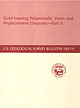
| Sphalerite and calcite, 5 cm across, Denton mine, Hardin County. Ross Lillie specimen. +!.+!+%% 34!2+ ...chalcopyrite, and sphalerite, 12.7 cm high, Hardin County. Marv Rausch specimen. 3(%,"9 -!#/50). /5 ....outwash deposits. The Illinois-Kentucky fluorspar district in the extreme southeast corner of the state has...to the mid-1970s were documented with the exact mine or in many cases even the correct subdistrict. In...Mississippi Valley zinc-lead district. This area has been an active mining district from about the middle of |
 | | Book (edition) |
| sOO0Ofoss Colorado LITHO BY WALSWORTH PUB. CO., INC., MARCELINE, MO. Colorado GOLD AND FARMS...Denver, of all other McMahon, unpublished Mining District, in reproduction. map Colo. places Albuquerque...Albuquerque, NM of Leadville a map of Territorial Colorado c. 1876, and a woodcut engraving Bird’s Eye View...scock G. York, Includes indexes. 1. Colorado. 2. Colorado. is Waele. Mines and mineral resources--...DressOne. MEXIC ies 35 Publisher’s Preface Colorado! The very name (which means “‘colored red’’) conjures |
 | | Journal (issue) |
| Stampede. Phoenix, Arizona. February 17-22 — Riverside County Fair and National Date Festival. Indio, California...trip to Borrego, Calif. February 20-28 — Maricopa County Fair, Mesa, Arizona. February 21—Desert Sun Ranchers'...desert ADVENTURE W h e r e Lake M e a d Meets the Colorado By HULBERT BURROUGHS W i n g s in the Desert Hills...m p , a n d other desert p o e m s . . . . LOST MINE The Sewing Basket's Secret By WAYNE WINTERS 3...WILDFLOWERS Forecast for F e b r u a r y 27 MINING Current n e w s of desert mines 28 NEWS From |
| | Book (edition) |
| org/details/coloradoitsgolds1880foss 77 Colorado Gold and Silver Mines, FARMS AND STOCK RANGES...r^HIS volume, as its name implies, is devoted to Colorado. Its con¬ tents are descriptive, statistical...interests. devoted to the mines. Part fourth is As mining is Colorado’s main industry and source of wealth...could make them. The narrative of gold and silver mining possesses enough of romance and adventure to interest...general reader, and the descriptions of mines, and of mining and milling, together with statements of requisite |
 | | Report (volume) |
| . 234 " y { " ,-t .. .~,:",. I " , COLORADO "or.! _ +, (~ STATE OF .~ :'(' COL~ADO /... BULLETIN 40 RADIOACTIVE MINERAL OCCURRENCES OF COLORADO AND BlaLlllGRAPHY by James L. Nelson-Moore,...Energy COLORADO GEOLOGICAL SURVEY DEPARTMENT OF NATURAL RESUURCES STATE OF COLORADO DENVER, COLORADO 1978...ete 11 st r ng of rad i aaet 1ve occurrences 1n Colorado, with a comprehensive blbi iography and bibliographic...on the Colorado Plateau sparked several periods of exploratIon that ultimately led to a mining "boom ll |
 | | Report (issue) |
| given to the mining of stibnite-bearing lodes, but it soon subsided. The Big Hurrah quartz mine is the only...was opened up on any considerable scale, and this mine was operated only from 1903 to 1908 and then not...underground work has been done at the Lost River tin mine, the Kougarok silver-lead property, and the gold...J. Collier: Bull. 259, pp. 120-127, 1905. Gold mining on Seward Peninsula, by F. H. Moffit: Bull. 284...Creek region, by P. S. Smith: Idem, pp. 306-354. Mining in the Fairhaven Precinct, by F. F. Henshaw: Idem |
 | | Report (issue) |
| . . . . . . . . Other Deposits (Blaelis Copper Mine and Tarraloola) The Gascoyne GoldfieldThe Mangaroon...('attlrn Group T h e Klverdton Mine The 1)esmond Mine l'lre 311. Renwn Mine 181 1$2 182 183 184 185 hillips...zones from the surface down t o about 100 feet, and mining has ceased when these easily won reserves have...Whim Creek, Thaduna, Eulaminna, and the Elverdton Mine at Ravensthorpe. The Northampton deposits lie in...Goldfield (principally..the 'Copper Hills Copper Mine) and the Peak Hi11 Goldfield (principally Thaduna) |
 | | Report (issue) |
| predecessor organization, the Manhattan Engineer District ; and, to a lesser extent, by staff members of...United States. The pre-1940 history of uranium mining and geology is concerned largely with veins in...such areas as the Front Range mineral belt of Colorado; the Boulder batholith area, Montana ; the Sierra...Marysvale district, Utah. All the Western States, including Arizona, California, Colorado~ Idaho, Montana...comments on the history of uranium geology and mining. The other chapters deal principally with pertinent |
 | | Report (issue) |
| with published data and information provided by mining companies to give an account of each deposit and....................................... Whim Creek mine ...................................................................................... Mons Cupri mine ...................................................... Evelyn copper mine ............................... Yannery Hill copper mine ....................................................... Breens copper mine ............................................... |


