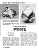
 | | Journal (article/letter/editorial) | | (above). Pyrite, Alice Glory Hole, Clear Creek County. Cluster of intergrown crystals showing light...(right). Pyrite, Mountain Spring mine, Rico, Dolores County. Cluster of modified cubes; specimen 2 by 2 inches;...C*O*L*O*R*A*D*O PYRITE BARBARA L. MUNTYAN Ouray County Museum Ouray, Colorado 81427 Mineral photographs by John R...Park City, Utah; Washington State; and numerous Colorado localities. Pyrite crystallizes in the isometric...Pyrite is the most common sulfide mineral found in Colorado; it is found in a wide variety of occurrences |  | | Report (issue) | | Bldg., 2600 corridor, 18th and CSts.,NW. DENVER, Colorado-Federal Bldg., Rm. 169,1961 Stout St. LOS ANGELES...ROLLA, Missouri-1400 Independence Rd. DENVER, Colorado-Map Distribution, Bldg. 810, Federal Center FAIRBANKS...Part II Geology and Gold Deposits of the Oatman District, Northwestern Arizona By ED DEWITT, JON P. THORSON...Marysville Mining District, Montana By JAMES W. WHIPPLE Gold Deposits of the Boulder County Gold District...District, Colorado By JAMES A. SAUNDERS Part I is Chapter H U.S. GEOLOGICAL SURVEY BULLETIN 1857 GEOLOGY |  | Collins, Donley S., Cobban, Robert R., Foord, Eugene E., Murphy, Jack A. (1989) Bibliography for update and revision of U.S.G.S. Bulletin 1114, Minerals of Colorado -- a 100 year record, by Edwin B. Eckel, Part A - Paper copy --Bibliography data file disks. Open-File Report Vol. 1989 (89-206) US Geological Survey doi:10.3133/ofr89206a | Report (issue) | | Survey Denver, Colorado Department of Geology, Denver Museum of Natural History Denver, Colorado NOTE FOR...revision of U.S.G.S. Bulletin 1114, Minerals of Colorado A 100 year record, by Edwin B. Eckel By Donley...Prepared in cooperation with Friends of Mineralogy - Colorado Chaptar, and the Denver Museum of Natural History...references dealing with the mineralogy of the state of Colorado. It is part of a more than 10 year effort to update...and revise U.S.G.S. Bulletin 1114, Minerals of Colorado: A 100 year record, by Edwin B. Eckel (1961). |  | | Report (issue) | | BULLETIN 71 Mineral Resources of Taos County, New Mexico by JOHN H. SCHILLING Description of mineral...INSTITUTE OF MINING & TECHNOLOGY CAMPUS STATION SOCORRO, NEW MEXICO NEW MEXICO INSTITUTE OF MINING 8c TECHNOLOGY................................... 11 HISTORY OF MINING ......................................................................... 44 BJB [Wilde, Goat Hill Gulch] prospects ........................................................ 49 Prospects along Spring Gulch ............................................... |  | | Report (issue) | | Geology and Ore Deposits of the Front Range Colorado By T. S. LO\'ERING and E. N. GODDARD GEOLOGICAL...cooperation with the Colorado State Geological Survey Board and the Colorado Metal Mining Fund ~ oopr is...__________________________________________ _ 1 Summary of mining districts---.---------------------Introduction..._ Quartz diorite and associated hornblendite_ Boulder Creek granite _________________ _ Pikes Peak granite..._____________________ _ Copper deposits in Jefferson County __ _ F. M.D. property _____________ _ Malachite |  | | Report (issue) | | of the Questa Molybdenum (Moly) Mine Area, Taos County, New Mexico BY JOHN H. SCHILLING Local structure...INSTITUTE OF MINING & TECHNOLOGY CAMPUS STATION SOCORRO, NEW MEXICO NEW MEXICO INSTITUTE OF MINING & TECHNOLOGY....... Albuquerque FRONTISPIECE View of Sulphur Gulch showing W level dump (lower left), landslide covering...area — hydrothermal pipe — at the head of Sulphur Gulch (treeless area, upper right). Contents Page ABSTRACT................................................8 Mining Methods ...................................... |  | | Report (issue) | | Geological Survey Investigation of Baseline and Pre-Mining Ground-Water Quality in the Red River Valley Basin...OF THE INTERIOR U.S. GEOLOGICAL SURVEY Denver, Colorado This report is available at: http://geology.cr.......................................... Goat Hill Gulch ...............................................appears to be more extensive at the unmined Goat Hill Gulch and the mined ground, than the "scars" to the..."scar" areas. Introduction A baseline and pre-mining ground-water quality study of the Red River Valley |  | | Report (issue) | | INSTITUTE OF MINING & TECHNOLOGY CAMPUS STATION SOCORRO, NEW MEXICO NEW MEXICO INSTITUTE OF MINING Sc TECHNOLOGY............................................... 7 Mining ................................................................................. Rhenium in molybdenite ........................................................................ Petaca mining district, Rio Arriba County ...................................25 25 25 Page Other occurrences, Rio Arriba County .............................................. |  | | Report (volume) | | V2-MINUTE QUADRANGLES, PIONEER MOUNTAINS, BEAVERHEAD COUNTY, MONTANA Glendale, Mont., in 1883 (top). This...the Colorado Group. The hills in the upper right part of the picture are south of Dry Hollow Gulch; from...valley between the two groups of hills is the Trusty Gulch syncline; the sharp knobs in the center of the valley...1f2-Minute Quadrangles, Pioneer Mountains, Beaverhead County, Montana ByE-AN ZEN A description of the stratigraphy...7112-minute quadrangles, Pioneer Mountains, Beaverhead County, Montana. (U.S. Geological Survey bulletin ; 1625) |  | | Book (edition) | | INSTITUTE OF MINING AND TECHNOLOGY Socorro - New Mexico NEW MEXICO INSTITUTE OF MINING AND TECHNOLOGY...surrounding countryside. No railroads enter Taos County, and there is no heavy industry. The outlying villages...The mountain area is thinly populated; tourists, mining, summer grazing of cattle and sheep in the high...mountains to Twining (16 miles), once a copper mining camp, now a skiing center. The scenery is well...areas look like at close range. 38.2 Cross Goat Hill Gulch on short bridge. For the next 0.8 mile the gravel |  | | Journal (article/letter/editorial) | | Climax-type porphyries and some others in the Colorado mineral belt. By-product molybdenum contained...Mo deposits, ore elements. l. Introduction Molybdenite deposits occur in various tectonic settings in...Climax, Henderson, and Mt. Emmons deposits of the Colorado mineral belt, and vein, stockwork and breccia...(Villeneuve et al., 2001). It is restricted to molybdenite-quartz stockwork formed on an elongated easterly...porphyry, occurs in the sedimentary basement. The molybdenite-quartz veins hosted in the intrusive rocks are |  | | Book (edition) | | Resources A DIVISION OF NEW MEXICO INSTITUTE OF MINING & TECHNOLOGY The enchanted circle— loop drives...80225 SOCORRO 1991 iv NEW MEXICO INSTITUTE OF MINING & TECHNOLOGY Laurence H. Lattman, President NEW...Director, Bus./Pub. Office ROBERT W. EVELETH, Senior Mining Engineer LOIS GOLLMER, Staff Secretary IBRAHIM...GRAMBLING, UNM RICHARD W. HARRISON, T or C CAROL A. HILL, Albuquerque ALONZO D. JACKA, Texas Tech BOB JULYAN...Socorro, New Mexico, Reno, Nevada, and Denver, Colorado April 1991 J. E. Taggart, Jr. Geologist, U.S |  | | Report (issue) | | Director A Division of New Mexico Institute of Mining and Technology Stirling A. Colgate, President ...110 RIO HONDO DISTRICT 110 Geology, mineralization, production 111 RED RIVER DISTRICT 111 General geology...ELIZABETHTOWN-BALDY DISTRICT 120 Hematite Creek district 121 West Moreno district 121 Elizabethtown-Baldy...compared with adjacent areas in New Mexico and Colorado 5—Modal analyses of Tertiary granites 6—Chemical...Contemporaneously, metallization occurred in the Red River district in fissure veins and disseminations. The Questa |  | Plumlee, Geoff, Lowers, Heather, Ludington, Steve, Koenig, Alan, Briggs, Paul (2005) Questa baseline and pre-mining ground-water quality invistigation. 13. Mineral microscopy and chemistry of mined and unmined porphyry molybdenum mineralization along the Red River, New Mexico: Implications for ground- and surface-water quality. Open-File Report 2005-1442. US Geological Survey doi:10.3133/ofr20051442 | Report (issue) | | i Questa baseline and pre-mining ground-water quality investigation. 13. Mineral microscopy and chemistry... and Briggs, P., 2005, Questa baseline and pre-mining ground-water quality investigation. 13. Mineral...contained within this report. Questa baseline and pre-mining ground-water quality investigation. 13. Mineral...overall goal of the USGS study is to infer the pre-mining ground-water quality at the Molycorp mine site...watershed prior to openpit and underground molybdenite mining at Molycorp’s Questa mine. The stretch of |  | | Book (volume) | | ae TONITE TN263. Au. =American Institute of Mining, Metallurgical, V.2 and Petroleum Engineers Ore...Inst! itute i an Americ ie Lye 2 of llurgical, Mining, Meta m Engineers and Petroleu © f the Ore deposiits...AND ZINC (1936) 134, MILLING METHODs 141, METAL MINING (1939) (1937-40) BLAST FURNACE, COKE OVEN AND...AIME TRANSACTIONS VOLUME 178, MINING GEOLOGY AIME TRANSACTIONS 181, MINING, INDUSTRIAL MINERALS, EDUCATION...I! Published by : : The American Institute of Mining, Metallurgical, and Petroleum Engineers, Inc. NEW |  | | Report (issue) | | Economic Geology of the ·central City District .Gilpin County, Colorado By PAUL K. SIMS, A. A. DRAKE, ]R....Economic geology of the Central City district, Gilpin County, Colorado, by Paul K. Sims, A.A. Drake,. Jr...Central City district, Gilpin County, Colorado. 1963. (Card 2) 1. Geology, Economic-Colorado-Central City...City district. 2. Ore-deposits-Colorado-Central City district. 3. Mines and mineral re. sources-Colorado-Central...sources-Colorado-Central City district. I. Drake, Avery Ala, 1927joint author. II. Tooker, Edwin Wilson, 1923- joint |  | | Report (issue) | | the northern Cordillera: Canadian Institute of Mining and Metallurgy Special Volume 37. p. 1-18. Adair...metamorphosed hydrothermal system at Pine Canyon. Piute County, Utah. U.S.A. [abs.]: Mineralogical Society (London)...New Guinea: Melbourne, Australasian Institute of Mining and Metallurgy Monograph 14, p. 819-826. Aho, A...mineralogy of the Cerrillos copper deposit, Santa Fe County, New Mexico: New Mexico Geological Society Guidebook...northwest Scotland: Transactions Institution of Mining and Metallurgy, Section B, Applied Earth Sciences |  | | Report (volume) | | Anchorage district _ Redoubt district ___-_ _ Valdez Creek district __ _ Willow Creek district Yentna district...district _____________ _ ____ __________ _____ Copper River region __ _ _ _ Chistochina district Nelchina...Nelchina district __ __ _ Nizina district ___ Prince William Sound district ______________________ Yakataga...Yakataga district _______________________________ Kenai Peninsula region _ ___ _ ______ ________ _ Homer...Homer district ______________________ __________ ___ _ Hope district _ _ _ _ Seward district ____ _ __ _ ___ |  | | Report (volume) | | 723 GEOLOGY AND ORE DEPOSITS OF THE MANHATTAN DISTRICT NEVADA BY HENRY G. FERGUSON WASHINGTON GOVERNMENT...rocks___________r_________________________ Gold Hill formation______________1 _____________ Ordovician...Tertiary rocks________ _____ __ 114 Ores in the Gold Hill formation_________________ 114 Limestone ores __...Older gravel_______________________________ 120 Gulch gravel _______________________________ 121 The ...Geologic map and structure sections of the Manhattan district, Nev __.. _______________:____<.___.___ In pocket |  | | Report (volume) | | Geophysical Setting of the Colorado Plateau Neogene Uplift and Radial Collapse of the Colorado Plateau-Regional...by Kim R. Sullivan Reevaluation of the Central Colorado Plateau Laccoliths in the Light of New Age Determinations...Lineaments in the Northern Paradox Basin, Utah and Colorado, by Jules D. Friedman Processes of Laccolithic...Regional Tectonic Setting The Petrogenesis of the Colorado Plateau Laccoliths and Their Relationship to Regional...Crustal Extension in the Southeastern Paradox Basin, Colorado, by Marilyn A. Grout and Earl R. Verbeek Relation |  | | Report (volume) | | professional code: Mayr, E., 2. Davis, M. J., 1. Boulder batholith, Montana: Knopf, Various species: Link... Crossroads: Lyons, P. L., 4. Gilbert H., 10. Colorado, South Silverton area: Expanding horizons: Lay...the future: Just, E. ing: Burwell, E. B., Jr., 4. Mining geology, retrospect and Index fossils: Stephenson..., 11. D. J. Rocky Mtn. geosyncline in Canada: Colorado Plateau: Wengerd, Warren; P. S., 4. S. A., 6.... Landform interpretation, stereoSearch for new mining districts: Nolan, T. B., 1. pairs: Powers, W. E |  | | Report (issue) | | younger h1gh-s1Uca rhyoMtes and granites from Colorado and north-central New Mexico by 1X Celia H....younger high-silica rhyolites and granites from Colorado and north-central New Wexico Celia H. Steigerwald*...younger high-silica rhyolites and granites from Colorado and north-central Ney Mexico* The data were compiled...deposits* and for the many granite molybdenite system prospects in Colorado* We then decided to broaden the...younger high-silica rhyolites and granites in Colorado for which chemical data were available* Our aim |  | | Report (volume) | | M.E., Mining Geology Geophysics Div. Ann. Mtg., Abs. Tech. PapersAmerican Institute of Mining and Metallurgical...Metallurgical Engineers, · Mining Geology Geophysics Division Annual Meeting, Abstracts of Technical Papers...New York. A.I.M.E. Trans.-American Institute of Mining and Metallurgical Engineers Transactions. New York...Ontario. Canadian Inst. Mining and Metallurgy Trans.-Canadian Institute of Mining and Metallurgy Transactions...our.-Canadian Mining Journal. Gardenvale, Quebec. Canadian Min. Metall. BulL-Canadian Mining and Metallurgical |  | | Report (volume) | | ...................................... 36 Molybdenite........................................................... Lode mining.............................................. Placer mining............................. ....:......... ^............ Oceanic Mining Company......................:............ Holkham...................................... History of mining operations............................ Production...statement..................................... 77 Hill and gulch placers.................................. 78 |  | | Report (volume) | | Atlantic Coastal Plain, the Appalachians, the Colorado Plateau, and the Williston basin. Examples of...subject headings are as follows: COLORADO. Mineralogy. Montrose County, uranium-vanadium deposits: Weeks...Iron, Cook County, titaniferous magnetite: Grout, F. F., 5. IRON. Minnesota, Cook County, titaniferous...and have not been searched completely. A.I.M.E., Mining Geology Geophysics Div. Ann. Mtg., Abs. Tech. Papers;...Br. Abs. American Institute of Mining and Metallurgical Engineers, Mining, Geology, and Geophysics Division |
|


