 | | Report (issue) | | QuadranglMontana By GEORGE E. BECRAFT, DARRELL M. PINCKNEY, and...Lewis and Cl ark Counties, Montana. 1963. (Card 2) 1 1. 'Geology-Montana-.Jefferson City quadrangle...C:ity quadrangle. 3. Mines and mineral resources-Montana-Jefferson City quadrangle. I. Pinckney, Darrell...Rocks of the Boulder batholith __________________ _ Butte quartz monzonite _____________________ _ Rock type...___________________________________ _ History of mining in the region __________________ _ Production- |  | | Book (edition) | | McDonald Co\·er photo: \\ 7 ulfenite, Rowley Mine, Maricopa County, 4 cm high specimen, Evan and Melissa Jones...used mining districts as part of the locality description. These political and geographic district names...with a more descriptive term, metallic mineral district. This term shows the geochemical and mineralogical...reader to learn more about the geology of the district and to possibly predict the minerals that could...districts. Where possible, the metallic mineral district for each mineral locality is given for the mineral |  | | Journal (article/letter/editorial) | | Butte, Montana Minerals, Mines, and History Robert E. Jenkins 6 Columbus Circle Newark, Delaware 19702...of 130 mineral species have been recorded from Butte. Specimens of copper sulfides and sulfosalts like...rank among the finest in the world. The best of Butte pyrite compares with the best anywhere. Handsome...Handsome specimens of barite, quartz, rhodochrosite, silver, and numerous other species have been found, many...Kelley #2 (rightbackground) mines, Butte, ca. 1965. World Museum of Mining photo. 6 The Mineralogical Record |  | | Journal (issue) | | BUTTE, MONTANA Butte, Montana Minerals, Mines and History The Mineralogical Record Volume 33 • Number...crystal cluster, 3 cm across, From the Leonard mine, Butte, Montana. Frederick H. Pough collection; Jeff Scovil...painted to illustrate “The Story of Montana: The Treasure of Butte Hill and Development of the Great Copper...volume 33, January–February, 2002 Contents Butte, Montana: Minerals, Mines and History By Robert E. Jenkins...Jenkins & Jerry A. Lorengo Ed McDole: “Montana Mineral King” By Richard A. Bideaux What’s new in minerals: |  | | Book | | " \ AN)» el \} -w y = —Z- es MC =) a oS MINING 147 AND MINERAL OPERATIONS IN THE ROCKY MOUNTAIN...cataloged as follows: United States. Bureau of Mines. Mining and mineral operations in the Rocky Mountain States;...and nonmetallics. Stable and economic domestic mining, mineral, metal, and mineral reclamation industries...enjoy your experiences. This pamphlet, a guide to mining and mineral operations that may be observed or...aid tourists and students who are interested in mining. Some may wish to study our Nation’s romantic past; |  | | Report (issue) | | Mear the Oentral Part of the Lemhl Range, Lemhi County, Itlaho tJ.S, GEOLOGICAL SURVEY PROFESSIONAL PAPER...Near the Central Part of the Lemhi Range, Lemhi County, Idaho By EDWARD T. RUPPEL and DAVID A. LOPEZ ...near the central part of the Lemhi Range, Lemhi County, Idaho. (U.S. Geological Survey professional paper..... Railroad Canyon Formation ................ Bluebird Mountain Formation .............. Pennsylvanian...................................... History of mining ............................... Structural and |  | | Report (issue) | | geographic coordinates and, where applicable, by county and section, township, and range. Both published...nickel-plus-copper in the deposit. The Gap mine (Pennsylvania) and the San Julian mine (California),are examples of...these deposits varies widely. Some, like the Bluebird mine (Arizona), are small deposits containing 16...16 mostly only cobalt minerals. At the Standard mine (Oregon), the , cobalt minerals are associated...present in separate ore shoots. In the Blackbird district (Idaho), the amount of copper present is greater |  | | Report (issue) | | Idaho: Volume III: Miscellaneous Properties, Owyhee County, Idaho Earl H. Bennett, John Kauffman, and Victoria...Idaho: Volume III: Miscellaneous Properties, Owyhee County, Idaho Earl H. Bennett, John Kauffman, and Victoria...MINES . . . . . . . . . . . . . . . 2 1.4.1 Acid Mine Drainage . . . . . . . . . . . . . . . . . . . ... . . 7 1.5.3.1 Soil, Rock, Stream Sediment, and Mine Waste Sampling Procedures . . . . . . . . . . .... . . . 11 2.0 MISCELLANEOUS PROPERTIES, OWYHEE COUNTY, IDAHO . . . . . . . . . . . . . . . . . 12 2.1 |  | | Report (issue) | | _________________ ___. Nevada ___________ Elko County. - ______ ... _ Star mine, Harrison Pass _____ ____ Pag« 59...63 Good Hope barite mine, Tuscarora Range _____ _ ._. ________ Humboldt County Golconda manganese-tungsten...Ltd., mine...... --_--______.______ Lincoln County__-__-----_-----_-----___ Tern Piute district.........district____ .________..__ Nevada Scheelite mine.. _ ______ Hooper No. 2 mine __ _____ _ _ Yankee Girl mine_______________...Mountains_____________.____ Desert Scheelite mine..... _______ Gunmetal mine _ ___________ _ Manganese-tungsten |  | | Journal (article/letter/editorial) | | GRANITE ROCKS OF BUTTE, MONT., AND VICINITY1 IN the western mountainous part of Montana there are several...from those tributary to the Pacific Ocean. This district is largely drained by the Boulder River, and as...the Highland Mountains (sixteen miles south of Butte) to the vicinity. of Helena, a distance of fifty...where the rock has been quarried or exposed by mining operations. It is a medium to coarse-grained rock...141. JOUR. GEOL., Vol. VII, GRANITE ROCKS OF BUTTE, MONT., AND VICINITY 739 In the following table |  | | Report (issue) | | area are or have been major producers of gold, silver, copper, lead, zinc, tungsten, antimony, and molybdenum...of the project. This was designed to find which mining properties might contain hazardous materials (HazMat)...HazMat problems include significant amounts of acid mine drainage, sulfide waste material in close proximity...stored fuels, chemicals, or explosives left from mining operations. Physical hazards consist of unmarked...detailed histories were prepared for sixty of the mining properties on the priority lists (Appendix A). |  | | Report (issue) | | study area, Custer and Gallatin National Forests, Montana Edited by JANE M. HAMMARSTROM1, MICHAEL L. ZIENTEK2...Study Area, Custer and Gallatin National Forests, Montana U.S. Geological Survey Open-File Report 93-207...700 km2) of National Forest land in southwestern Montana adjacent to the northern part of Yellowstone National...resources in the U.S., as well as significant gold, silver, copper, lead, and zinc resources. Mines have operated...the area since the 1860's and have produced gold, silver, arsenic, tungsten, copper, lead, zinc, chromium |  | | Report (issue) | | ............................. President, Idaho Mining Association Jack Peterson .......................Stratigaphy and Structure of the Milligen Formation, Sun Valley Area, Idaho 1.53 Robert J. W. Turner and Bruce...Deposits of the Carrietown Counties, Idaho Silver-Lead-Zinc District, Blaine and Camas Robert S. Darling...Fart A. Glacial Deposits of the Big Wood River Valley 203 Suzanne Pearce, Gunnar Schlieder, and Edward...Evenson Part C. History of Gold Mining on the Yankee Fork River, Custer County 223 George C. Stephens Part |  | | Report (issue) | | Is EIN Mining Industry of IDAHO FOR THE YEAR 1928 UUUGEQEONGRGOUUEEEOOUOONGOUUOOGOQEOOOQOUVONOQO...EcIUUUGGMOUAN THIRTIETH ANNUAL REPORT OF THE Mining Industry of IDAHO FOR THE YEAR 1928 STEWART INSPECTOR...Sem OWNERSHIP STS VIS OF TIMBER ON UNPATENTED MINING 2 cere ee Ra ye pe a a RLECTRICIEY ON THE COURT...BBAR GIAKBS COUINT Yee cele ewe ds IBDN BEWAH. COUNTY 1M nook oe 0d ee a 0 ee ae ee ie yee IBUINGTRUAINE...ee BONNER (COUNTY. Ci. 0 ee es et ee BONUNB VAMGIEES (COUNTY 2.5 kool ee BOUNDARY: COUNTY. cis -t:50 |  | | Report (issue) | | deposits Cochise County . Coconino County 4 6 Gila County . . . . . . . . . 7 Graham County . . 7 Greenlee...Greenlee County 8 La Paz County. . . 8 Maricopa County 9 Mohave County · 10 Navajo County Pima County...County. . · 11 Yavapai County .. · 11 . . . . 13 . . . . .. . 16 16 Yuma County . . . · 18 Pinal...Pinal County. . Santa Cruz County Commodity Abbreviations AU - gold AG - silver CU - copper SA - barium... Niemuth and Ken. A. Phillips Exploration and mining companies are showing renewed interest in Arizona |  | | Report (issue) | | Coppermolybdenum mineralization at Mineral Park, Mojsve County, Arizona, in Ridge. J. D., Ore deposits of the...Volume), v. 2: New York, American Institute of Mining, Metallurgical, and Petroleum Engineers, p. 1256-1281...mineralization in the Gold BasinLost Basin mining districts, Mojave County, Arizona: Geological Society of America...Economic Geology, v. 67, p. 664-878. Globe-Miami district 33°20» x 110°45' Porphyry Cu K-Ar 63.340.5...deposition of porphyry copper ores, Globe-Miami district. Arizona: Economic Geology, v. 75, p. 830-844 |  | | Report (issue) | | TWENTY- NINTH ANNUAL REPORT OF THE Mining Industry of IDAHO FOR THE YEAR’ 1927 STEWART INSPECTOR...MINES ° TWENTY- NINTH ANNUAL REPORT OF THE Mining Industry of IDAHO FOR THE YEAR 1927 STEWART INSPECTOR...neh IBEUSHAZZARS WITH ask a Ae Se et ee Oe ee ae MINE SRESCUEAIN 2THEl@OBUR aDHA TOBINGao oeeeies te eee...IBANINOCK COUNTY i xcec2 oh cccen eke tee ceca ksee see oe coe ee Beeroeeree BEAR SIGAKE: COUNTY: cn 625...625 Se a, oe ee BENE WAH COUNTY: coristoc a cers ows thea ts eared eee econ ee STN GET A\Miig, CO WINIEXS |  | | Report (issue) | | _ Herkimer limestone.__------___-____________ Bluebird dolomite.________________________ Cole Canyon...--------_----_40 18. "Twiggy" dolomite bed of Bluebird type in white-weathering dolomite near top of...shale member of Deseret limestone, Tintic mining district, Juab County______________________________...the Herkimer limestone, 350-430 feet thick; the Bluebird dolomite, 150-200 feet thick; and the Cole Canyon...Cambrian fossils. In the Tintic and East Tintic mining districts, where the Ophir formation is 400-425 |  | | Report (volume) | | Jackson Mountains Wilderness Study Area, Humboldt County/ Nevada U.S. GEOLOGICAL SURVEY BULLETIN 1726-B...Jackson Mountains Wilderness Study Area, Humboldt County, Nevada By MARTIN L. SORENSEN, DONALD PLOUFF, and...Jackson Mountains Wilderness Study Area, Humboldt County, Nevada. U.S. Geological Survey Bulletin 1726-B...Mountains Wilderness Study Area (NV-020-603), Humboldt County, Nevada. CONTENTS Summary Bl Abstract 1 Character...energy resource potential 8 Iron resources 8 Gold, silver, lead, and zinc resources in massive sulfide deposits |  | | Report (issue) | | 74 GEOLOGY AND ORE DEPOSITS OF THE BUTTE DISTRICT, MONTANA BY \¥ALTER I-IAllVEY vVEED WASHINGTON......................... ~ . . . . Epoch of gold mining ................................................. . . . . . . . . . . . . . . . . Epoch o'f silver mining ........· ......... ·................................. ~.............. Development of copper mining. ~ ..· . . . . . . . . . . . . . . . . . . . ................................... Future of the district .................................. ·......... |  | | Report (volume) | | 147 N., R. 84 W., 4 km N of Riverdale, McLean County, N. Oak. Named for Aggie Brown Coulee, which flows...NW1/4NW1/4SW1/4SW1/4 sec. 17, T. 85 N., R. 7 W., Linn County, Iowa. A-L Peak Rhyolite Oligocene 1. New Mexico...structures in the San Mateo Mountains, Socorro County, New Mexico: New Mexico Geol. Soc. Spec. Pub. 5...Mountains, 10. sees. 33-35, T. 4 S., R. 6 W., Socorro County, N.Mex. Anapra Sandstone 1. Early Cretaceous 2...6. 7. 9. 10. at Cerro de Cristo Rey, Dofta Ana County, New Mexico, Appendix 2 in Lovejoy, E. M. P., Geology |  | | Book | | i0000malo_g608 The Battle for Butte The Battle for Butte MINING AND PoLitics ON THE NORTHERN FRONTIER...Malone Montana Historical Society Press Helena Cover photograph: Anaconda Hill, Butte, Montana, circa...circa 1900 (Montana Historical Society Photograph Archives) Cover design: Finstad Visual Design, Helena,... Montana Printed by Thomson-Shore, Inc., Dexter, Michigan Montana Historical Society Press 225 N. Roberts...Roberts St. P. O. Box 201201 Helena, Montana 59620-1201 © 1981 by the University of Washington Press |  | | Report (volume) | | study of parts of the Tintic and North Tin tic mining districts UNITED STATES GOVERNMENT PRINTING OFFICE...quadrapgle covers_ about 57 square miles in Tintic Valley and in an adjacent part of the_ central East Tintic...the Tintic mining district and the southwestern part of the North Tintic n1ining district. The rocks...monzonite of middle Eocene age; lacustrine and valley-fill deposits of Pliocene age; and colluvium, alluvium...fault-block range, and the northeastern part of Tintic Valley. Ll L2 CONTRIBUTIONS TO ECONOMIC GEOLOGY The |  | | Report (issue) | | Developments in Minerals, Mining, Energy, and Water Resources in Idaho for 1979 Idaho Bureau of Mines...Department of Water Resources U.S. Bureau of Mines Idaho Mining Association TeclmicaJ Report 80-12 1980 Idaho...Moscow, Idaho 83844 DEVELOPMENTS IN MINERALS, MINING, ENERGY, AND WATER RESOURCES IN IDAHO FOR 1979...of Water Resources U. S. Bureau of Mines Idaho Mining Association Idaho Geological Survey University...the Society of Economic Geologists, and the Idaho Mining Association. He was also a Fellow of the Geological |  | | Report (issue) | | THIRTY -SECOND ANNUAL REPORT OF THE Mining Industry of IDAHO FOR THE YEAR STEWART INSPECTOR CAMPBELL...OF MINES THIRTY -SECOND ANNUAL REPORT OF THE Mining Industry of IDAHO FOR THE YEAR 1930 STEWART INSPECTOR...activities a Bunker Hill & Sullivan M. & C. Co.: Valley County.........-+-+++++-+-:eae 6 t Fo ine oIOks Crate...aa woe RAe hemor (Goviboahhb plant of Sullivan Mining Co........--+-++.++++55 Electrolytic cadmium acca...alent ines INew hoist of Sunshine Mining COm.. ta Sherman Howe Mining Co.......... Bs od gMey a a aDaylcbA |
|

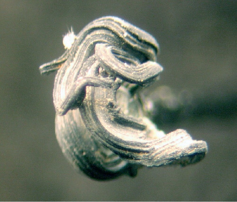


Bluebird Mine, Butte Mining District, Silver Bow County, Montana, USA