 | | Report (issue) |
| GOLD LODE MINING IN THE WILLOW CREEK DISTRICT. By STEPHEN R. CAPPS. INTRODUCTION. Gold mining in the Willow...Willow Creek district in 1917 was confined to the exploitation of the quartz lodes, from which almost...gold recovered from this area was gained by placer mining, the workable placers were soon exhausted, and...mines. Two of these mines, the Gold Bullion and the Alaska Free Gold, have been in operation for many years...produced the bulk of the output of the district. The Independence mine, which has for years been a producer |
 | | Report (volume) |
| Radioactivity Investigations in the Cache Creek Area Yentna District Alaska, 1945 GEOLOGICAL SURVEY BULLETIN... Radioactivity Investigations in the Cache Creek Area Yentna District Alaska, 1945 By G. D. ROBINSON, HELMUTH WEDOW...LYONS MINERAL GEOLOGICAL RESOURCES SURVEY OF ALASKA BULLETIN 1024-A This report concerns work done...Cache Creek area, showing sample localities. Traverses on Cache Creek upstream from Nugget Creek. Traverses...Traverses on Nugget Creek. Traverses on Cache Creek between Rambler Creek and Nugget Creek. Traverses on Thunder |
 | | Report (issue) |
| projects were under way in preparation for productive mining. In other words, the work of the prospector and...and that of the capitalist, guided by the mining engineer, showed advances during the year. There is good...that the widespread pessimism in regard to the Alaska mining industry that has persisted during the postwar...returns from the exploitation of bonanza placer mining, which are so favorable to local communities, are...improved mining methods. However, in practice these methods require the services of mining engineers |
 | | Report (issue) |
| OCCURRENCES, AID GEOCHEMICAL ANOMALIES OF THE YENTNA DISTRICT, .ALASKA By A. L. Clark and C. C. Hawley Open-file...rocks Elemental composition of dike rocks Thunder Creek altered zone Structure Significance of silica-carbonate...the auriferous white quartz Willow Creek Dollar Creek Thunder Creek Distribution White quartz conglomerate...deposits xSllTu Windy Creek General features Glacio-fluvial placer deposits Cache Creek stream and bench...and recommendations Mt. Goldie anomaly Bunco Creek area Stream sediment geochemical anomalies LiOJ-Dy |
 | | Report (issue) |
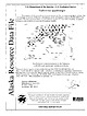
| mines, prospects and mineral occurrences throughout Alaska. 153 00 63 00 TL004 TL005 TL006 * (i|:4 TL069...Talkeetna 1:250,000-scale quadrangle, southcentral Alaska This and related reports are accessible through...110631 Anchorage, AK 99511 Location of map area in Alaska This report is preliminary and has not been reviewed...REPORT 99-139 ZUSGS science for a changing world Alaska Resource Data File TL001 Site name(s): Boedeker;...the Hidden River, a short distance east of Swift Creek. The prospect is at an elevation of 4000 feet in |
 | | Report (volume) |
| Placer Deposits of Alaska By EDWARD H. COBB GEOLOGICAL SURVEY BULLETIN 1374 An inventory of the...the placer mines and prospects of Alaska, their history and geologic setting UNITED STATES GOVERNMENT...and method of presentation __ Definitions _-____ Alaska Peninsula region Aleutian Islands region ________...Inlet-Susitna River region Anchorage district _ Redoubt district ___-_ _ Valdez Creek district __ _ Willow...Willow Creek district Yentna district _____________ _ ____ __________ _____ Copper River region __ _ |
 | | Report (issue) |
| HAKEINGTON. SUMMARY OF MINING OPERATIONS. t A resume of the history of tin mining in Alaska up to 1914 has been...his report. Stream tin was first found on Buhner Creek, a tributary of Anikovik River, in 1900, and there...since 1902. In 1911 a dredge was installed on Buck Creek which has been in operation each season since. Two...following season. A second dredge was installed on Buck Creek in 1915 and has worked each summer since that date...hull in 1916 and installed on a dredge on Swanson Creek, a tributary of Agiapuk Eiver. The hull was carried |
 | | Report (volume) |
| Smith, Director Bulletin 813 MINERAL RESOURCES OF ALASKA REPORT ON PROGRESS OF INVESTIGATIONS IN 1928 BY...Price 40 cents CONTENTS . Mineral industry of Alaska in 1928, by Philip S. Smith._______-___ Administrative...by S. R. Capps____________________ Mining in the Fortymile district, by J. B. Mertie, jr_______-_ _-______...Selected list of Geological Survey publications on Alaska.______________ Page 1 73 97 125 143 165 I ILLUSTRATIONS...1. Sketch map of the Chakachamna-Stony region, Alaska, showing areas in which timber occurs...'_--____-__--_- |
 | | Journal (article/letter/editorial) |
| and location. Deposit/Prospect Intrusion Area/Mining Camp (MC) Lac Troilus Côté Gold Central Camp MOP-II...mineralization East Sullivan Hwy-44 property Thunder Creek McIntyre-Hollinger Golden (Canadian) Arrow Kelore...Bourlamaque MOP-II Golden Arrow √ √ √ √ √ √ √ Thunder Creek √ McIntyre-Hollinger Selbaie Kiena Doyon...with the polymetallic mineralization of the Selbaie mine [30]. This mineralization consists of polymetallic...mineralization pattern [34,35]. As for the Selbaie mine, these porphyries tend to postdate VMS mineralization |
 | | Report (issue) |
| RUBY-KUSKOKWIM REGION ALASKA BY J. B. MERTIE, Jr. Mineral resources of Alaska, 1933 (Pages 115-245)...________-_______-__-____---__-_____--__________-___ Ruby district._______-___-____--._-_--.-__---_--__._______ Ruby...area____-______.__--_-___--__-_-___-_________ 145 Long Creek and Bear Gulch..____________________ Fifth of July...______________________ Greenstone Creek.._______._________._._-_._.___._ Monument Creek.______________________________...Meketchum Creek._______________________________ Trail Creek____.________________________ Flint Creek and tributaries |
 | | Report (volume) |
| Geophysical Union.. Transactions, American Institute of Mining and Metallurgical Engineers _..._ American Journal...Colorado Mining Association publications . Economic Geology. _ . _ ___... Engineering and Mining Journal...of Sedimentary Petrology_...__._ Mines Magazine Mining Engineering ........___..._...._____ Advances in...Utah; and the E. F. Glover Building, Anchorage, Alaska. Circulars (Index Nos. 200-297) are free on application...in Anchorage and College, Alaska ALM U.S. Bureau of Mines, Anchorage, Alaska ALT Territorial Department |
 | | Report (issue) |
| _________ Platinum-group minerals from Goodnews Bay, Alaska _______________________ Miscellaneous studies __________________..._________________________ Sulfur isotopes, Bingham district, Utah_ _____ Geochemical sampling _________________...and extends from the Bootstrap mine in Elko County south to Hot Creek in Nye County. These preliminary...quartz-pyrite-gold veins in quartz monzonite at Mill Creek near Cortez, Nev., indicate a formation temperature...Lander, and other small deposits in the Tenabo district, Nevada, homogenize from as high as 325° C for |
 | | Book |
| stumble over a valuable nugget and stake your own mining claim? Indeed it to is, and author book Jay...prospecting, he points out, is in abandoned mining districts, where valuable mineral ores are present...RANSOM 1875-1948 An to the Eastern '‘Schoolmarm” Mining Camps of the Old West I I a s I \ h K... CONTENTS Preface ix PART I 1 Introduction to Mining and Mineralogy 2 Preparation for Mineral Collecting...61 232 PART The Making 43 II 5 7 3 III Mine PART 267 IV Glossary 279 Bibliography 291 |
 | | Report (issue) |
| description of the geology, mining history, and production of the major gold-mining districts in 21 States...relations ---------------------------History of gold mining and trends in production_ J\labama -----------...--------------------------Alaska -----------------------------------------Cook Inlet-Susitna region --------------------Copper...J\la:ska region ------------------Southwestern Alaska region ------------------1'ukon region -------...fee County ------------------------------Clear Creek County -------------------------Custer County - |
 | | Report (volume) |
| crystalline rocks____-_________.._____________ Alaska._____-_____-__________---_-_--___-____-_____-_________..._________--____-_---_-------___-_--------_----_______ Ajo district.-_--_.____---------______--_-_--__---_______ Oatman...______--__-__---_____----_____-__-___-___________ Bonanza district._________________________________________ Breckenridge...region___________________________________________ Spanish Peaks district.____________________________________ Summitville...________________________________________ Edwardsburg district._____________________________________ 11 11 12 |
 | | Book |
| to Find Gems and Minerals in L.\merica Alabama Alaska Arkansas Arizona California Colorado Connecticut...of commercial mining is also long, beginning with the Kenya opal mines of 4000 B.C. Mining began with gemstones...gemstones, instead of metallic ores, and mining for turquoise was enormously extended throughout the...aphtali). Third row: ligure (possibly jacinth, yellow zircon, or hyacinth, e.g., essonite garnet; an undetermined...had been sending great expeditions to prospect and mine for it throughout the Sinai Peninsula since at least |
 | | Book (volume) |
| instance, a single Spodumene crystal from the Etta Mine near Keystone on the east side of the Mount Rushmore...United States CUSTER COUNTY AREA: The November Mine, 1.2 mi. SE of the Needles Eye Tunnel, on the W...Kasolite, Quartz crystals, Mica, Tourmaline and Zircon (reddish brown crystals); W 14 mi. on US 16 to...outcrops and ridgesFairhill agates; in Bull Moose mine dump 5 mi. SE Barbosalite, exceptional reddish-violet...AREA: The Uranium-Vanadium mines of the Edgemont Mining Dist.Autunite, Becquerelite, Carnotite, Coffinite |
 | | Report (issue) |
| resources National Petroleum Reserve in Alaska _____ Offshore Alaska _____________________ Rocky Mountains...Oregon Western United States Washington California Alaska Statewide Northern West-central East-central Southern...______________________ Mapping land cover in northern Alaska with Landsat digital data _____________________...______________Department of the Interior DOMES ___Deep Ocean Mining Environmental Study DSDP _____________Deep Sea...Ocean Survey NPRA _______Naval Petroleum Reserve in Alaska NRA _____________National Resources Agency NRA |
 | | Report (volume) |
| resources National Petroleum Reserve in Alaska _____ Offshore Alaska _____________________ Rocky Mountains...Oregon Western United States Washington California Alaska Statewide Northern West-central East-central Southern...______________________ Mapping land cover in northern Alaska with Landsat digital data _____________________...______________Department of the Interior DOMES ___Deep Ocean Mining Environmental Study DSDP _____________Deep Sea...Ocean Survey NPRA _______Naval Petroleum Reserve in Alaska NRA _____________National Resources Agency NRA |
 | | Report (issue) |
| p. 323, reproduced from the cover of Canadian Mining Journal, February, 1975). ine Ontario Geological...Saskatchewan Float, Occurrences «05-2. Algoma District........ fe. Aikens Island, Float No. tee Wg...: Canadian Charleson Limited ...........Vendome Mine, Fiedmont Township, Quebec. . . . Pardee Township...9 40 sae U)............-. el 42 Cochrane District sces 1s Float No.1-Zn Auden Township .. ...coc) Bay Area Float No. 1- Au ae Yee Kenora District (Patricia Portion)....... Balmer Township Float |
 | | Book (volume) |
| ⎯cone-in-cone Calcite. CLERMONT COUNTY MILFORD, area creek gravels and alluvial deposits, rare⎯Diamond. CLINTON...Untied States townships of Franklin, Keene, Mill Creek and Tuscarawas, as hard dark gray to black nodules⎯flint...Berlin, Hardy, Killbuck, Mechanic, Paint and Salt Creek (with occurrences in shale or sandstone); and conspicuous...Clark (limestone occurrences), Prairie and Walnut Creek⎯flint. JACKSON COUNTY AREA, townships of Bloomfield...worked, as nodules⎯flint; d townships of Monday Creek, Salt Lick, Pike and Clayton, area⎯flint. ROSS |
 | | Report (issue) |
| Pacific coast region.___-___-__--__--________ Alaska. __-----__---_---___.-____ _ General--..__________________...__________________ New paleontological discoveries in Alaska-Northern Alaska______________________ West-central...Alaska__________________. East-central Alaska-._____--_-_-_-______ Southwestern Alaska-__---_---_--__---_Southern..._______ Guam. ________________________________ Alaska. _______________________________ Washington- _...Pacific continental margin ___________________ Alaska continental margin. __________________ Oceanic |
 | | Report (issue) |
| S. geothermal re·sources assessed-Continued 40 Alaska ---------------------------41 Arizona ___ ----...---------Washington ---------------------------Alaska ------------------------------------General --...-------------------------------Northern Alaska ------------------------ 44 44 44 45 45 46 46 46 47 48...investigations-Continued Alaska-Continued Central Alaska ------------------------Southern Alaska -----------------------SouthE'...-----------------------SouthE'.astern Alaska ___________________ _ Puerto Rico -------------------------------Geologic |
 | | Journal (issue) |
| MINING WORLD CATALOG, SURVEY & DIRECTORY NUMBER Blue Pages Pink Section Yellow Pages DIRECTORY INDEX...United States Mining in 1960 State-by-state report from and MINING to zinc Alaska to Wyoming e 8s...Shipments by mines for 1958, 1959, 1960 B96 Open Pit Mine Production ef 3 Technological ; Advances Tons...Tons mined and stripped & 99 Underground Mine Production from 1955 through 1960 > 101 Geology and...—==erererr Ofslo(Seep colitetol Mining Open Pit Mining World-Wide Mining Reports Africa-Asia-Caribbean-Europe |


