 | | Book | | anc MINERALS OF MEXICO 7 | : = Pras #0 AaprTTARE ; | MINERALS OF MEXICO William D. Panczner...1938Minerals of Mexico. Bibliography: p. 1. Mineralogy— Collectors and collecting— Mexico. 2. Mines and...and mineral resources— Mexico. I. Title. QE377.M6P36 1987 549.972 86-13325 ISBN 0-442-27285-5 This book...Boletin nuimeros 40 and 41 (Instituto Geoldgico de México, 1922, 1923), has an author been able...It is the hope and wish of the Sociedad Mexicana de Mineralogia, which promotes the study of Mexican | 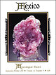 | | Journal (issue) | | localities: The Trucco mining district, Taxco de Alarcon, Guerrero, Mexico ...................................mineral localities: The Refugio mine, Municipio de Choix, Sinaloa, Mexico ................................Wilson Jlerro de Jllercado Famous mineral localities: Cerro de Mercado, Durango, Mexico ................Ferry ~alace of Jlline_s The Palace of Mines in Mexico City .................................... .497...Smithsonite, 4 cm wide, from the Refugio mine, Choix, Sinaloa, Mexico. William Dameron collection; Jesse Fisher | | | Book | | "'<' ~/ BOUNDARIES U A Mo<'« u~ o V :¾ MEXICO r - ·•-.. ·-··-··-··-·· < •• ....... V S TATES...org/details/mineralsofmexico0000panc MINERALS OF MEXICO • ERALS OF ~XICO M ______ William D. Panczner...1938Minerals of Mexico. Bibliography: p. 1. Mineralogy-Collectors and collecting-Mexico. 2. Mines and mineral...mineral resources-Mexico. I. Title. QE377.M6P36 1987 549.972 86-13325 ISBN 0-442-27285-5 This boo i...i.. is deJicated tu the people of Mexico and to the three people who directly affected me and this project |  | | Journal (article/letter/editorial) | | Mesozoic and Cenozoic mineral depositsfrom northern Mexico. These deposits can be divided into massive sulfide...averageage of Precambrianbasementrocks in northern Mexico. We interpret these observationsto suggestthat...Precambrianbasementrock extendsbeneathmost of northern Mexico and contributed significant amounts of lead to...better understandingof the tectonic evolutionof Mexico (McDowell and Keizer, 1977; Barker, 1977; Gastil...Tehuantepec,we have con- Mineralizati0n in Northern Mexico The Mesozoicand Cenozoicmineral depositsthat have |  | | Report (issue) | | System, South-Central Colorado and North-Central New Mexico U.S. GEOLOGICAL SURVEY BULLETIN 1 787^EE ......System, South-Central Colorado and North-Central New Mexico By AUGUSTUS K. ARMSTRONG, BERNARD L. MAMET, and...System, south-central Colorado and north-central New Mexico / by Augustus K. Armstrong, Bernard L. Mamet, and...Mississippian. 2. Geology Colorado. 3. Geology New Mexico. I. Mamet, Bernard L. II. Repetski, John E. III...Glenwood Springs section EE6 Oilman section EE7 Sherman Mine section EE7 Fourmile Creek section EE7 Dolomitized |  | | Journal (issue) | | Mine-ralNe Vol 15 No. 9 September. 1999 Hanson Aggregates Midwest Flemingsburg, Kentucky Quarry Alan...Kentucky, photo by Mark A. Schneider. Other News from Mexico 1993 to 1997 Jean des Rivieres Maryfield, Albany...minute drive south of Mexico City and a 45 minutes drive further south to Taxco. Every third weekend...weekend, I would drive to Taxco to enjoy a day or lunch in that beautiful traditional Mexican town. Occasionally...I made friends with several Mexican Nationals, Taxco residents, owner of some of the claims in Amatitlan |  | | Report (issue) | | north-central New Mexico._____ Kelly Limestone of the Ladron Mountains, west-central New Mexico __________________...Kelly Limestone, Ladron Mountains, westcentral New Mexico _________________________________- __ -Regional...Colorado, to the Ladron Mountains of west-central New Mexico _____ _ ____ ___ __ _ --Idealized Late Devonian...Colorado and northern New Mexico _ _-Paleogeographic map of northern New Mexico, southern Colorado, and...time, in northern Arizona, southern Colorado, New Mexico, and southern Utah. The crinoid-foraminifer limestone |  | | Book | | K FIELD GUIDE to the GEMS and MINERALS of MEXICO (Exclusive of Baja California) A guide to the...Information............ Driving in Mexico................... Trailcring in Mexico ............. 5 6 6 7 8 8........ A Word to the Wise ............. Jade in Mexico......................... Manto and Chimney Deposits.................. Los Lamentos District.... Placer de Guadalupe Puerto del Aire District Chihuahua ......El Potosi Mine............. San Antonio Mine....... Cusihuiriachic District..... Barranca de Cobre (Copper |  | | Report (issue) | | Eagle Nest Area New Mexico Photo on title page: Lake Fork valley from Frazer mine, Twining Fairview Mountain...Mountain at right NEW MEXICO STATE BUREAU OF MINES AND MINERAL RESOURCES BULLETIN 94 1972 GEOLOGY...EAGLE NEST AREA, NEW MEXICO by KENNETH F. CLARK and CHARLES B. READ iv New Mexico State Bureau of Mines...Resources Don H. Baker, Jr., Director A Division of New Mexico Institute of Mining and Technology Stirling A....REGENTS Ex Officio Bruce King, Governor of New Mexico Leonard DeLayo, Superintendent of Public Instruction |  | | Book | | Chicago, cor. Clinton and Fulton Sts. St. TUBOS DE HIERRO MALEABLE, Con Remates a Martillo; para Aceite...una Cota que precave del Orin. Tubos para Pailas de Locomotoras y Eslacionarias. SURTIDORES 6 INYECTORES... Para Alimentar Patente de Mack. las Pailas con Agua Caliente. TUBOS DE AGUA. Los hacemos especialmente...especialmente ligeros que pesan una (1-4) menos que de hierro colado, siendo ademas mucho mas fuertes. Son...time. By Frederick A. Ober, aiuhor of" Travels in Mexico," " Camps in the Caiibbees," etc. With 100 Illustrations |  | | Report (issue) | | . . . . . . . . . . . . 91 Gary Hoffmann, Eli Silver, Simon Day, Eugene Morgan, Neal Driscoll, and Daniel...Schouten, and Louis Teng 13. The Guerrero Composite Terrane of western Mexico: Collision and subsequent rifting.... . . . . . . . . . 279 E. Centeno-García, M. Guerrero-Suastegui, and O. Talavera-Mendoza 14. Tectonic...the highly complex tectonic evolution of western Mexico, including multiple stages of terrane collision...Eglington, B.M., Armstrong, R.A., de Beer, C.H., Martini, J.E.J., de Kock, G.S., Macey, P.H., and Ingram |  | | Book (volume) | | ECONOMIC GEOLOGY, MEXICO The Geology of North America O r > W 4^ *1^ ^ ^ \ \ f ax4 u \ \...Economic Geology^ Mexico Edited by Guillermo P. Salas Geologo Consultor Asesor del Consejo de Recursos Minerales...Centro Minero Nacional Carretera Mexico-Pachuca Pachuca, Hgo., Mexico, D.F. 1991 EXPLORATION LIBRARY...Phillips Petroleum Company . Shell Oil Company Caswell Silver Standard Oil Production Company Oryx Energy Company...reserved. Geologia economica de Mexico. English. Economic geology, Mexico / edited by Guillermo P. Salas |  | | Journal (article/letter/editorial) | | 2016 Mashamba West Mine, Shaba, Democratic Republic of Congo, and Red Dome Mine, Queensland, Australia...familiar with porphyry copper deposits of Arizona, New Mexico, and Utah. Many of the world’s finest specimens...formerly found in beautiful specimens” at the McGinn mine in Mecklenburg County and at several of the copper...Minor chalcotrichite is reported from the Clark mine, and octahedral cuprite crystals to 7 mm and cuprite-included...the Allouez mine, Keweenaw County; good cuprite crystals have been found in the Indiana mine, and cuprite |  | | Journal (article/letter/editorial) | | largest island in the New Hebrides. Together with Espiritu Santo, which lies to the north and is the largest...ARCS The Miocene succession on the island of Espiritu Santo (JONES, 1967; ROBINSON, G. P., 1966, 1970)...broad belt of similar rocks extending through Espiritu Santo accumulate in and around the northward continuation...Group and similar deposits of the same age in Espiritu Santo, to the north of Malekula, accumulated i n...DAVIES, D. K . , 1968. Carbonate turbidites, Gulf of Mexico. J. Sediment. Petrol., 38:llOO-1109. DONNELLY, |  | | Report (issue) | | in the Eastern San Juan Basin and Vicinity, New Mexico Trace Fossils and Mollusks from the Upper Member...Member of the Wanakah Formation, Chama Basin, New Mexico: Evidence for a Lacustrine Origin Stratigraphy,...Rocks in the San Juan Basin of Northwestern New Mexico and Adjacent Areas U.S. GEOLOGICAL SURVEY BULLETIN...in the Eastern San Juan Basin and Vicinity, New Mexico 'By RUSSELL F. DUBIEL Trace Fossils and Mollusks...Member of the Wanakah Formation, Chama Basin, New Mexico: Evidence for a Lacustrine Origin By JENNIE L. |  | Heindel, Katrin, Birgel, Daniel, Brunner, Benjamin, Thiel, Volker, Westphal, Hildegard, Gischler, Eberhard, Ziegenbalg, Simone B., Cabioch, Guy, Sjövall, Peter, Peckmann, Jörn (2012) Post-glacial microbialite formation in coral reefs of the Pacific, Atlantic, and Indian Oceans. Chemical Geology, 304. 117-130 doi:10.1016/j.chemgeo.2012.02.009 | Journal (article/letter/editorial) | | 60438 Frankfurt am Main, Germany g IRD, Centre d'Ile de France, 93143 Bondy CEDEX, France h SP Technical...The site Tasmaloum is located in the south of Espiritu Santo Island and the site Urélapa is an islet eastward...eastward of Tasmaloum (Fig. 2). Espiritu Santo is part of the volcanically active island chain composing...Pacific plate. The study area southwest of Espiritu Santo was rapidly uplifted with a rate of 5 to 6...Tasmaloum and Urélapa in the south of the island Espiritu Santo) and the non-volcanic sites Belize Barrier |  | | Journal (article/letter/editorial) | | THOMSON. Four hundred years ago last year, Vasco Nunez de Balboa looked down upon the waters of the Pacific...ships deserted the first " beachcomber," one Gonzalo de Vigo, a native of Galicia, who, with two sailors...mutiny. Saavedra died at sea on the voyage back to Mexico. Had he lived, we are assured by Galvao, he would...the unknown, Cortes despatched three ships from Mexico under the command of Saavedra, to find him. This...that the Santiago carried forty- five and the Espiritu Santo fifteen men. If they had carried any women |  | | Report (issue) | | *Achiras (Argentina) Acme (New Mexico) Adams County (Colorado) Adargas (Mexico) 1941 1917 1924 1902 1947...*Akwanga (Nigeria) *Alais (France) Alamogordo (New Mexico) *Aldsworth (England) *Aleppo (Syria) * Alessandria...Cb Cc Cb Ch Cb Og Ch Anoka (Minnesota) Apoala (Mexico) *Appley Bridge (England) *Apt (France) Arcadia...Arcadia (Nebraska) * Archie (Missouri) Arispe (Mexico) Arlington (Minnesota) Arriba (Colorado) Artracoona (Australia)...1894 1936 1914 1805 1901 1846 1886 *Atemajac (Mexico) Atlanta (Louisiana) Auburn (Alabama) NAME AND |  | | Journal (volume) | | Public Domain in New Mexico 1854-1891 24 Victor Westphall El Cerrito, New Mexico Charles P. Loomis :...Documents THE NEW MEXICO HISTORICAL REVIEW is published jointly by the Historical Society Mexico and the University...University of New Mexico. Subscription to the quarterly is $3.00 a year in advance; single numbers, except...addressed to Prof. Frank D. Reeve, University of New Mexico, Albuquerque, N. M. Business Museum, Santa ;...matter at Santa Fe, New Mexico UNIVERSITY PRESS, ALBUQUERQUE, N. M. NEW MEXICO HISTORICAL REVIEW CONTENTS |  | | Report (issue) | | and to place in perspective potential impacts of mine dewatering and depressurization on ground-water...sandstones deposited in the Cretaceous Seaway from New Mexico t o Wyoming. Although the maximum recoverable gas...stratigraphic framework of the northwestern Gulf of Mexico. The correlations relate operational units to the...chemists Continuation of this study on theorigin of silver-copperlead deposits in red-bed sequences of the...Hazel Formation was about 4 million troy ounces of silver. Geographic positions, structural settings, vein |  | , , , , , (1980) Mineral resources of the Pecos wilderness and adjacent areas, Santa Fe, San Miguel, Mora, Rio Arriba, and Taos counties, New Mexico. Open-File Report Vol. 1980 (80-382) US Geological Survey doi:10.3133/ofr80382 | Report (issue) | | Taos Counties, New Mexico by U.S. Geological Survey, U.S. Bureau of Mines, and New Mexico Bureau of Mines...Counties, New Mexico By Robert H. Moench, U.S. Geological Survey, and James M. Robertson, New Mexico Bureau...Counties, New Mexico By Robert H. Moench, U.S. Geological Survey, James M. Robertson, New Mexico Bureau of...Miguel, Mora, Rio Arriba, and Taos Counties, New Mexico By Michael E. Lane, U.S. Bureau of Mines Open-File...Miguel, Mora, Rio Arriba, and Taos Counties, New Mexico: Summary*•••...••••.••••••.•••*•••••.•..•.••••••• |  | | Report (issue) | | BULLETIN 68 Gypsum Resources of New Mexico by ROBERT H. WEBER and FRANK E. KOTTLOWSKI 1959 STATE BUREAU...RESOURCES NEW MEXICO INSTITUTE OF MINING & TECHNOLOGY CAMPUS STATION SOCORRO, NEW MEXICO NEW MEXICO INSTITUTE...Burroughs .......................... Governor of New Mexico Tom Wiley .................................................... Albuquerque For sale by the New Mexico Bureau of Mines & Mineral Resources Campus Station........................ 5 GYPSUM DEPOSITS IN NEW MEXICO .............................................. |  | | Book | | Carlos Prieto Chairman, Cia. Fund Fierro y Acero de Mo In exploring the history of colonial mining in...Company New York Dusseldorf Johannesburg Mexico City Rio de Janeiro St. Louis San Francisco Kuala... SA ee » Se pa a: " Pa PR 7 ps a | Lario De AID JS ds fe PE = E ES > 0 ae ee yn yl a...Prieto meved to Mexico and soon was qualified by the Universidad Autónoma Nacional in Mexico City to practice...legal division of the Compania Fundidora de Fierro y Acero de Monterrey, S.A. (Monterrey Iron and ix |  | | Book | | life World Library: Mexico and The Andean Republics. He also wrote Heroic Mexico, a history of the Mexican...Heseai er: Martha T. Goolricl loris Coffin. Angela De Researchers Margo Drydt Villette Harris, Helen M...of Sea of Cortez, for the Spanish conqueror of Mexico, and the Vermilion line lie Sea; it is now ...California separates it from the rest of the republic of Mexico, of which it is a part but with which it has little...snow clad, frequently visible both from mainland Mexico, 140 miles away, and from far out in the Pacific |  | | Report (volume) | | Greendale syncline in southwest Virginia, by Wallace de Witt, Jr _______________ 46 Abandonment of the Indian...Penasco Group and divided into (ascending): Espiritu Santo Formation and its Del Padre Sandstone Member...Overlies Reedsville Shale; underlies Juniata Formation, (de Witt, 1974.) Barnett Hill Formation of Harlton (1938)...Bigelow Brook Formation-- Ordovician(?) to Early De- Northeast-central Connecvonian(?). ticut and south-central...Brimfield Schist (of Putnam Ordovician(?) to Early De- Massachusetts, ConnecGroup). vonian(?). ticut, and |
|


