 | | Report (issue) | | X-ray Powder Pattern: Tiburon Peninsula, California, USA. 2.624 (100), 1.550 (80), 2.726 (70), 4.84...93 100.00 11.47 (1) Tiburon Peninsula, California, USA; corresponds to (Ca0:98 K0:02 Mg0:01 Na0:01...crossite, muscovite, jadeite, glaucophane, quartz, Distribution: In the USA, in California, numerous...Marin Co.; at Arroyo Mocho, Alameda Co.; on Porter Creek, Sonoma Co.; Panoche Pass, San Benito Co.; in the...Scottish-American geologist, University of California, Berkeley, California, USA. Type Material: National Museum | 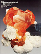 | | Journal (issue) | | mine pegmatites, Ramona district, San Diego County, California ............................101 by E. E.... B. Spaulding R. A. Mason & R. F. Martin , California locality index ...........................................129 by A. R. Kampf & the Southern California Chapter of the Friends of Mineralogy, Locality...e P e g m a t it e s , istrc San Diego D ,California Eugene E. Foord U. S. Geological Survey, M....Louis B. Spaulding, Jr. P. O. Box 807, Ramona, California 92065 Roger A. M ason Dept, of Earth Sciences |  | | Report (issue) | | M^iajKaMVMtrVMMIMMVW^- 'Vv s > MINERALS Of CALIFORNIA BULl,ETIN N«, 91 issei0 BY rr: ^ ;wIFORNIA...BULLETIN [November, 1922 No. 91 Minerals of California $ BY ARTHUR S. EAKLE, Ph. D. Professor...Mineralogy, University of California COMPLIMENTS OF ^^^foyd Sc, c/iosty GIST CALIFORNIA STATE PRINTING OFFICE...Stephens, Governor of the State of California, Sacramento, California Sir: I have the honor to transmit...upon the minerals of California. This bulletin records our knowledge of California minerals to date, |  | | Journal (article/letter/editorial) | | .................................. 574 Lower California-Colorado Desert area. By J.W yatt Durham.......East side of San Joaquin Valley, Bakersfield, California. By Glenn C. Ferguson.................. 581 Reef...and Robert T. White. 583 Tumey Gulch-Domengine Creek area. By Hubert G. Schenck and Robert T. W hite.................................... 591 Columbia County, Oregon, area. By C. E. Weaver................................................ 592 Grays Harbor County. By C. E. Weaver.............................. |  | | Report (issue) | | MINERALS OF CALIFORNIA BULLETIN No STATE ; . .. : DlViSIi BUILDIN 113 COLLEGE OF AGRICULTURE...AGRICULTURE DAVIS, CALIFORNIA STATE OF CAUFORNIA DEPABTMENT OF NATURAL RESOURCES GEORGE D. NORDENHOLT, Director...MINERALS OF CALIFORNIA By ADOLF PABST Associate Professor of Mineralogy University of California BERKELEY...BERKELEY CALIFORNIA STATE PRINTING OFFICE GEORGE H. MOORE. State Printer SACRAMENTO. 51440 1938 TABLE...Letter of Transmittal 5 Map 6 Outline o['. California Preface 7 Introduction 11 Native Elements |  | | Book | | MINERALS OF CALIFORNlA 299" 257889 PEMBERTON' HOFE CALIFORNIA MINERALS 2995 SEP 1933 OINCO Digitized by...org/details/mineralsofcalifo00pemb MINERALS OF CALIFORNIA - MINERALS OF CALIFORNIA H. Earl Pemberton ~ VAN NOSTRAND...H. Earl, 1907Minerals of California. An updating of: Minerals of California: centennial volume, 1866-1966...index. 1. Mineralogy - California. 2. Mines and mineral resources - California. I. MUidoch, J oseph, 1890Minerals...1890Minerals of California. 11. Title. QE375.C32P45 549.9794 81-15963 ISBN 0-442-274882 AACR2 Preface | | | Book | | 7 257989 R q549 PEMBERTON, H.E MINERALS OF CALIFORNIA P 2995 IpSl q 49 f 07. 257889 ^ pe B T...org/details/mineralsofcalifoOOpemb MINERALS OF CALIFORNIA MINERALS OF CALIFORNIA H. Earl r i L ] Pemberton ...H. Earl, 1907Minerals of California. An updating of: Minerals of California: 1866-1966 / by Joseph Murdoch...Includes index. 1. Mineralogy -California. 2. Mines and mineral resources- California. I. Murdoch, Joseph, 1890Minerals...1890Minerals of California. II. Title. centennial volume, QE375.C32P45 ISBN 0-442-27488 2 549.9794 |  | | Journal (volume) | | MAR1 v* 1950 STATE OF CALIFORNIA DEPARTMENT OF NATURAL RESOURCES CALIFORNIA JOURNAL OF MINES AND GEOLOGY...off California and Mexico 7 Geology Along the Electra and West Point Tunnels, Amador County, California...23 County, California Geology of the Placerita Oil Field, Perlite Deposits in Sonoma County, Mines... Los Angeles County, California of California Sonoma County, 43 81 83 California of the State...FERRY BUILDING, SAN FRANCISCO _ 143 STATE OF CALIFORNIA EARL WARREN, Governor DEPARTMENT OF NATURAL RESOURCES |  | | Report (issue) | | ] \ I ^,_|^_g|g„gy. MMM STATE OF CALIFORNIA GOODWIN I. KNIGHT, Governor DEPARTMENT OF... Chief BULLETIN December 173 MINERALS OF CALIFORNIA By JOSEPH MURDOCH University of Caliiomia,...ROBERT W. WEBB University of California, Santa Barbara College Goleta, California Price $3.00 LIBRARY UNIVERSITY...Goodwin J. Knight Governor of ihe State of California Dear Sir: I have the honor to transmit herewith...JenlCalifornia, Chief of the Division of Mines. Minerals of California is one of the Division's |  | | Report (issue) | | MINERALS OF CALIFORNIA THE GOLDEN BEAR The Golden Bear Nugget of Yankee is NUGGET said to have...found in the mining the nugget Jim, Placer County, California, in 1871 by a small girl in who town kept...are nuggets. The nugget was acquired by the California Federation of Minerologicol Societies insignia...in in the Cali- San Francisco MINERALS OF CALIFORNIA CENTENNIAL VOLUME by JOSEPH (1866-1966) MURDOCH...Ian Campbell and Eleanor M. Learned BULLETIN California Division of Ferry Building, San 189 Mines |  | | Report (issue) | | formerly U.S. Geological Survey Menlo Park, California CONTENTS Page Introduct ion Geology Radioactive...alluviated valleys are biotite granodiorite and muscovite-biotite granodiorite (Kiilsgaard and Lewis, 1985)...depths. The deepest hole drilled at the Pearsol Creek deposit (pi. 1, table 1) went to 120 ft without...radioactive minerals to greater depths. At the Pearsol Creek deposit in Long Valley, monazite values were found...ilmenite per cubic yard of gravel in the Pearsol Creek deposit (pi. 1, table 1). Ilmenite from 9 deposits |  | | Report (issue) | | eastern part of Bibb County, most of Twiggs County, the western part of Wilkinson County, and the northern...northern part of Bleckley County. The eastern part of the city of Macon is in the western part of the area...northeastern part, and Jeffersonville, the Twiggs County seat, is in the southern part of the district....of J. M. Huber Corporation in Flat Creek in central Twiggs County, near the southwest margin of the district...thickness for the Cretaceous beds in central Twiggs County is probably about 850 ft. (259 m) . The exposures |  | | Book (volume) | | THE SOUTHWESTERN QUADRANT Arizona, Arkansas, California, Colorado, Louisiana, Nevada, New Mexico, Oklahoma...The Southwestern Quadrant Arizoni, Arkansas, California, Colorado, Louisicna, Nevada, New Mexico, Oklahoma...Mineral Location Numbers Arizona Arkansas California Colorado 258 Louis B30 ana HOW TO USE...volumes, through very precise directions and accurate county maps, to get you to the best and most accessible...for the county in which it is located. This site number also appears under the given county in the text |  | Tabor, R.W., Booth, D.B., Vance, J.A., Ford, A.B., Ort, M.H. (1988) Preliminary geologic map of the Sauk River 30 by 60 minute Quadrangle, Washington. Open-File Report Vol. 1988 (88-692) US Geological Survey doi:10.3133/ofr88692 | Report (issue) | | present address: Dept. of Geol. Sciences Univ. of California, Santa Barbara Santa Barbara, CA 93106 ^present...^present address: Planning Department King County, Seattle, WA 98104 1988 Sources of Mop Compilation Data...mostly computer drawn. GENERAL GEOLOGY The Straight Creek fault almost bisects the Sauk River quadrangle....Within the Sauk River quadrangle, the Straight Creek fault mostly separates low grade rocks on the west...Vance (15576) (chevrons) Rocks well of the Slreiohl Creek fault Rocks SW of the DOMFZ Rocks in the DOMFZ |  | | Report (issue) | | COAL AT HORSESHOE BEND AND JERUSALEM VALLEY, BOISE COUNTY, IDAHO. By C. F. BOWEN. INTRODUCTION. PURPOSE AND...the district northward from the vicinity of Porter Creek. The basalt occurs between the granite and sedimentary...Bend and Jerusalem Valley coal field and the Goose Creek lignite district, Idaho (shaded portion). end of...syncline is present in the vicinity of Jackass Creek, as shown by eastward dips near Payette River and...eastern boundary of the formation. Farther north, on Porter and Brainard creeks, the dip seems to be uniformly |  | | Report (issue) | | FRONT COVER PHOTO : Gold nugget from Dukes Creek, White County, weight 5 oz., 12 dwt., approx. 2x. BACK...approx. 1.5x. Lower left - Goethite from Pulaski County, approx. lx. Right - Magnetite crystal face showing........................................... 143 Muscovite .......................................................................................... 170 County Index ...........................................from Washington and Bleck ley counties to Irwin county. Some minerals described herein have never been |  | | Journal (issue) | | Ronald K. Culbertson ........................ Myrtle Creek State Geologist ........................... Donald...successful drilling program at Mist Gas Field, Columbia County. Of the twelve wells drilled to the productive...quarter of a mile of the border to Clatsop County. Clatsop County wildcat wells permitted ARCO has received...received permits to drill in Clatsop County, about 12 mi northwest of Mist Gas Field. The permits are for...36-007-00020 NW'A sec. 33 T. 8 N., R. 6 W. Clatsop County Location; 6,000. 419 ARCO OR 13-33-86 36-007-00021 |  | | Report (issue) | | Perce Counties __________ _ Idaho CountY-----------------Valley CountY-----------------Adams, Payette,...and Gem Counties ________________________ _ Boise County ___ --------------Ada, Owyhee, Elmore, and Custer...Spruce Pine district ____________ Madison County and Haywood County _____________________ _ Zirconia district...monazite belt in the Piedmont province __ Stokes County and Surry County_ Wilkes, Alexander, Catawba, Caldwell...Rutherford County and Cleveland County __ --------------Lincoln County and Gaston County _____________________ |  | | Report (issue) | | ........................................ Apple Creek Formation................................................................................ Lawson Creek Formation............................................................ Basal dolomite of Bayhorse Creek......................................................................... Upper carbonate of Cash Creek.......................................................................................... Garden Creek Phyllite....................................... |  | | Report (volume) | | Highway 49 (Skyway Road) near town of Abel, Cleburne County. Absaroka Supergroup/Volcanic Supergroup U ABRK03...m 8. Washburn Group, Sunlight Group, Thorofare Creek Group g. Unconformably underlies Junction Butte...volcanic field, Yellowstone National Park, Park County, Wyo. Academy Church Shale Member (Springer Formation)...W1/2NW1/4NE1/4SE1/4 sec. 1, T. 3 s., R. 2 E., Carter County. Adams Formation ADMS01 1. Holocene 2. Alaska (SE)...Quadrangle, lat 45° N., long 70°50'-55' W., Oxford County. Adamstown Member (Frederick Limestone) U ADMS06 |  | | Journal (article/letter/editorial) | | was sampled in the north central part ofCampbell County, Wyoming. towards the central edStern margin ofthe...m rhick seam taken from a drill core in Coffee County. Alabama. IS 1) pica1 (1:ig. 5). The samples were...mineral partings. The sediments in the Porter’s Creek Formation, which probably constituted coastal highlands...of either or both of these minerals from the Porter Creek sediments could have been the source of the...in roof and floor and was there accompanied by muscovite (a potassium aluminosilicate). The minerals in |  | | Report (volume) | | Survey. Named for exposures at McBean and on McBean Creek, in Richmond Co., eastern Ga. McCann sandstone.... Permian : Central northern Oklahoma (Bay County). C. N. Gould, 1900 (Kans. Univ. Quart., vol. 9, pp...the Harper. Named for McCann's quarry, on Deer Creek, 20 mi. SW. of Blackwell, Kay Co. C. N. Gould, 1927... •S. 21st Ann. Rept., pt. 2, p. 426). McCarthy Creek shales.— A series of soft black, highly fissile...shales and slates, typically exposed on McCarthy Creek. Rest on Chitistone Is. Underlie (uncon.?) Kennicott |  | | Report (issue) | | llage ofActinolite in Elzevir Township, Hastings County . 31 F /1 5 Chemi cal analysis of a light greenish...actino l ite from Westmeath Township , Renfrew County: Si0 2 56 . 70 , Al 0 3 1. 62 , Fe o 3 . 06 , FeO...Township of St . Francis (Beauceville ) , Beauce County : Si0 52 . 30 , Al 2 o 1 . 30 , FeO 6 . 75, 2 3...syenites near Montreal in H oche laga County, and Beloeil in Rouville County (G. C . Hoffmann, 1 888 - 9 : Geol...rock butte in the wide pass at the head of Beatty Creek , about 1/2 mi l e east of Mes zah Peak , Leve l |  | | Journal (article/letter/editorial) | | ........................................ Stink Creek fault.............................................Frenchwoman Creek fault and associated folds............................................ Shell Creek fault...in upper Shell Creek Valley........................................... Upper Jimmy Creek area............................................... West Jimmy Creek fault................................................................................ East Jimmy Creek fault.......................................... |  | | Report (volume) | | "Names and Definitions of the Geological Units of California," Bulletin 826, by M. Grace Wilmarth. This work...reference for geologists who worked exclusively in California. The first exhaustive con1pilation, M. Grace...Underlies Church limestone member; overlies Bachelor Creek limestone member. M. R. Mudge, C. P. Walters, and...Bull. 1060-D, p. 193, 252-253, pl. 7. In Nemaha County, Kans., member is basal unit of Howard limestone...Aarde farm, sec. 4, T. 26 S., R. 11 E., Greenwood County. Aaron Slatet Precambrian or Paleozoic: Central |
|


