 | | Book (volume) | | 0 n101ercai o of Maine j f·~ ....__ :,,. . - .._"' ..;. .. ~ L-- -~ \. • .J_..::.; I Volume...History, Gems, and Geology edited by Vandall T. King Maine Geological Survey DEPARTMENT OF CONSERVATION Robert...Robert G. Marvinney, State Geologist of Maine Volume 2: Mining History, Gems, and Geology Edited by...Resources Information, Maine Geologi,cal Survey Robert G Marvinney, State Geologist Maine Geological Survey...DEPARTMENT OF CONSERVATION 2000 Copyright ©2000 by the Maine Geological Survey, Department of Conservation. All |  | | Book (volume) | | Dahlonega Co. and Rabum Co., and the McDuffie County Belt extending through portions of McDuffie, Warren...Sphalerite. BALDWIN COUNTY MILLEDGEVILLE, at state farmjasper. BANKS COUNTY COMMERCE, along Hwy. 59...along adjoining Co. linerock crystal. BARROW COUNTY WINDER, along rd. to Jefferson and 1½ mi. inside...Guide for Rock Hounds in the United States BARTOW COUNTY AREA, Saltpeter Cave, as floatjasper. CARTERSVILLE:...(banded, various colors), jasper. BIBB COUNTY MACON: at Holton Quarry, 7½ mi. NWagate; N of Calloway |  | | Book (volume) | | Mineralogy by Vandall T. King and Eugene E. Foord Maine Geological Survey DEPARTMENT OF CONSERVATION Walter...Resources Information, Maine Geological Survey Walter A. Anderson, State Geologist Maine Geological Survey...DEPARTMENT OF CONSERVATION 1994 Copyright ©1994 by the Maine Geological Survey, Department of Conservation. All...Cover photograph: Fluorapatite, Pulsifer quarry, Auburn, Maine (2.2 cm specimen), Harvard Mineralogical...Wendell E. Wilson, ©1985. The laws and policies of Maine and the United States prohibit discrimination in |  | | Book (volume) | | 600 to 800 feet thick in the north. ALEXANDER COUNTY FAYVILLE, area stream gravels⎯agate, jasper, rare...⎯agate, jasper; d RR siding of Clay⎯agate. CALHOUN COUNTY AREA, shores of the Mississippi R., in the Warsaw...crystals). CRAWFORD COUNTY PALESTINE, area deposits⎯Siderite. EDWARDS COUNTY AREA, T. 1 S, R. 10 E...E, regional deposits⎯Siderite. FULTON COUNTY FARMINGTON, W 6 mi. on Rte. 116 to the Rapatee No. 5 strip...mine⎯pyritized gastropods (Pennsylvanian age). GRUNDY COUNTY AREA: c Regional rd. and RR cuts and banks of Mason |  | | Book (volume) | | 600 to 800 feet thick in the north. ALEXANDER COUNTY FAYVILLE, area stream gravels⎯agate, jasper, rare...⎯agate, jasper; d RR siding of Clay⎯agate. CALHOUN COUNTY AREA, shores of the Mississippi R., in the Warsaw...crystals). CRAWFORD COUNTY PALESTINE, area deposits⎯Siderite. EDWARDS COUNTY AREA, T. 1 S, R. 10 E...E, regional deposits⎯Siderite. FULTON COUNTY FARMINGTON, W 6 mi. on Rte. 116 to the Rapatee No. 5 strip...mine⎯pyritized gastropods (Pennsylvanian age). GRUNDY COUNTY AREA: c Regional rd. and RR cuts and banks of Mason |  | | Journal (article/letter/editorial) | | the Sebago granite–pegmatite system, southern Maine, USA Michael A. Wise*, Cathleen D. Brown Department...situated in the Oxford pegmatite field, southwestern Maine. Surrounding the pluton is an area designated as...chemistry, petrology, geochemistry, Sebago, southern Maine Received: 1 October 2009; accepted: 30 March 2010;...Introduction The granitic pegmatites of southern Maine represent one of several major pegmatite regions...Unfortunately, very little geochemical data exist for the Maine pegmatites despite their popularity among mineral |  | | Journal (issue) | | Loren Merrill a century ago at Mt. Mica in Paris, Maine. This specimen was donated by Robert Whitmore. Patricia...White Mountains” has just rolled off the press. Maine co-authors are Dyk Eusden, Woody Thompson, and John...sometime around 1890 to 1913 at Mt. Mica in Paris, Maine. Since Merrill is a family name, I did some digging...(February 14, 1853- March 29, 1930) of Paris Hill, Maine was born the son of farmers James and Eliza Merrill...the mid to late 1880's at Mount Apatite, Auburn, Maine. Loren B. Merrill holding a large tourmaline crystal |  | | Book | | commercial ores and secondary minerals by state, county, township, and geologic range. For easy identification...cities, and many of today’s prosperous western county seats began as mining-boom camps. trating sand...Whether you such as those listed alphabetically by county, township, and range in Part II of this book. Where...granite which was pushed up from great depths. Maine), New California The gem Jersey, show pegmatites...will help you prospect and explore any state and county. etc., for mineral deposits in Finding Suitable |  | | Book (volume) | | ...........................................207 Maine .................................................................548 Table of Maps Page Alabama County Map ...................................................................................4 Alaska County and Stream Map ......................................................................22 Arizona County Map ................................................................................49 Arkansas County Map .......................................... |  | | Book (volume) | | ...........................................177 Maine...................................................rights, so remember you were told. If in doubt, a county map will tell you who the legal owner is. Good...gemmy qualities for cutting and polishing. AUTAUGA COUNTY PRATTVILLE, N. 6 mi., and just E of the Birmingham...were well known to prehistoric Indians.) BARBOUR COUNTY BAKER HILL, SE 1 mi. : 1 in a deep ravine, as a...deep red to variegated⎯ocher. BIBB COUNTY GENERAL AREA: c county gravel pits along the Cahaba R.⎯gemmy |  | | Book (volume) | | ...........................................177 Maine...................................................rights, so remember you were told. If in doubt, a county map will tell you who the legal owner is. Good...gemmy qualities for cutting and polishing. AUTAUGA COUNTY PRATTVILLE, N. 6 mi., and just E of the Birmingham...were well known to prehistoric Indians.) BARBOUR COUNTY BAKER HILL, SE 1 mi. : 1 in a deep ravine, as a...deep red to variegated⎯ocher. BIBB COUNTY GENERAL AREA: c county gravel pits along the Cahaba R.⎯gemmy |  | | Field Trip Notes | | Hampshire Field Trip No. 2, Outstanding pegmatites of Maine and New Hampshire 73 Geology of the "Chelmsford...inplace theory for the southern part, as in Dutchess County, New York. Whether such a combination of theories...(1914) Geology of the North Creek quadrangle, Warren County, New York, New York State Mus., Bull. 170. (1919)...Geology of the Schroon Lake quadrangle, Warren County, New York, New York State Mus., Bull. 213-214....(1936) Structural and petrologic studies in Duchess County, N. Y., Part I. Geologic structure of sedimentary |  | | Journal (issue) | | BD10 Power Feed Trim Saw Scan for Video MADE IN USA Features include: • All cast aluminum tank, table...# 168787 HP14 Slab Saw Scan for Video MADE IN USA Features include: • 1/2 HP continuous duty motor...CA San Francisco, CA Hilton Orange County/ Crystal Fair, County Fair Costa Mesa Building (Formerly Hall...ADMIS FIELD NOTES our staff Making Memories in Maine Several years ago, my friend and I signed up for...ive-day mining experience at Poland Mining Camp in Maine. We were given a simple cabin in the mountains and |  | | Book | | ANTIQUIITFS, HI.STORICAL AND MONUMENTAL, OF IDE COUNTY OF CORNWALL.’* Devon and Cornwall) were first...a large opening made in the ground, and in and quarry, the same shape. stone depth of a common dug abqut...part of Great Britain. All the historians of this county, from Leland, Norden, and Carew, downward, have...Carew, who, treating of the ancient extent oi the county, says ‘ The encroaching sea hath ravined from it...Edward IV. is often appealed to, to s,how that the county of Cornwall contained then twice the number of |  | | Book | | is the \Vholesale Agent to the Trade outside the County of London. 1914. Price Tliree Shillinr;.s and...pegmatite quarry, St. Yrieix .. . . .• ,, 16. Details of part of the Clos de Barre Quarry, St. Yrieix...Marcognac ... . . . · .. . .•• . .. ,, 18. Pougat's Quarry, Marcognac, in 1808 . .. ... ... . .. " 19~ Diagram...formatio11 at Queylou, L es Eyzies ..• ,, 24. Section of quarry on the plateau of Queylou . .. .. . . .. ,! 25...consolidation of the roe l{. It is evident that tourmaline (schorl) too is a prima1"y mine1..al to a large extent |  | | Book | | Zircon, Topaz, Emerald and Beryl, Tourmaline and Schorl, Olivine Granites and other igneous rocks. Cornish..... ....... 1 6. ,, 140 144 The 23. . Sturtevant open-door ring roll-mill 8. 8. . sectional...Common opal is often found in the vesicular lavas of County Antrim and the West of Scotland, etc. " Fire...reaching a thickness of 1000 ft. (2) found in County Antrim. Kieselguhr varies greatly in composition...convergent polarized light. Black tourmaline is called schorl, the red is rubellite, and the indigo blue |  | | Journal (volume) | | (Croatia) (Hungary) (Slovakia) (Greece) (Hungary) (USA) (Hungary) (Egypt) (Austria) (Romania) (Hungary)...(Hungary) (Hungary) (Hungary) (Croatia) (UK) (Slovakia) (USA) (Austria) (Romania) (Slovakia) (China) (Germany)...(Germany) (Poland) (Italy) (Czech Republic) (Romania/USA) (Germany) (Hungary) (Russia) (Czech Republic) (Japan)...Laboratory, Carnegie Institution, Washington DC, USA (rhazen@ciw.edu) The mineralogy of terrestrial planets...Chemistry/Biochemistry, Arizona State University, Tempe, AZ, USA (pbuseck@asu.edu) The warm feelings conveyed by Figure |  | | Journal (issue) | | pegmatite rich in tourmaline, and tourmaline or schorl rock (tourmaline and quartz) may be explained in...CIRCULARS, CHICAGO. ADVERTISEMENTS. THE STURTEVANT STEAM HOT-BLAST APPARATUS. TING SONIT VENTILATING...HEATING and FOR OFFICE AND WORKS: THE B. F. STURTEVANT G0, JAMAICA PLAIN, BOSTON, MASS. A. J. Wilkinson |  | | Report (issue) | | Granite-gneiss overlain by mantle Cbmpany's mine, Nelson CountY. of feldspathic facies of syenite from VIII. X'ig...Photomicrograph of gabbro from W. A. Campbell's farm' Nelson County...'.. X'is.3. Photomicrograph of feldspathic facies...northeast XXII. XX[I. of Mr.. .Grant,s house, Nelson County. . , . . . l. Outcrop showing contact between diabase...fine-graineil ilmmite nelsonite from Roanoke 188 County. 198 246 X'ig.2. Photomicrograph of epidote-bearing...epidote-bearing ilmenite nelsonite from Roanoke County. 245 X'ig.3. Photomicrograph of epidote-bearing ilmenite |  | | Book (edition) | | Yorkshire, England. United States AL Alabama ME Maine OR Oregon AK Alaska MD Maryland PA Pennsylvania...plant, supplies, and vehicles to reach a mine, quarry, or opencast pit. In remote and isolated regions...used for shaft sinking and moving wagon drills at quarry and opencast operations. Nelson air photograph...1 air-track drill A heavy drilling machine for quarry or opencast blasting. It has continuous tracks...3 to 4.9 m) wide in the Albert Shale of Albert County, NB, Can. It is partly soluble in turpentine, but |  | | Report (volume) | | sectwn of Paleozotc rocks from Butler County to Stafford County, Kansas Kansas Geol Survey Otl and Gas...wells on a cross section from Barber County, Kansas, to Caddo County, Oklahoma Oklahoma Geol Survey Gutdebook...deposits of East Shasta copper-z10c dtstnct, Shasta County, Cahforma U S Geol Survey Prof Paper 338, 107 p...4297 Anders, R B Ground-water geology of Karnes County, Texas US Geol Survey Water-Supply Paper 1539-G...water and changes 10 water levels 10 Galveston County, Texas, 1958-62 Texas Water Comm Bull 6303, 33 |  | | Journal (volume) | | iv CONTENTS. Gigantic Plant of Craigleith Quarry. 13. On Tertiary de- posites. 14. Chalk in the...in the Vigna Lovati, opposite St Prisca, where a quarry has been opened, from which, as Von Buch mentions...Forres, Lochindorb, and Inverness. The extensive county of Aberdeen appears to have been covered with wood...cultivation. Thus, in the Forest of Plater, in the county of Forfar, David the Second, in 1366, made a grant...or similar plant, in the kupJerschiefer of the county of Mansfeld. Single pieces of coal, in which the |  | | Book (volume) | | te Uw Ptnua} JviM M fliMitr ; K*»Wi.i it » USA sr«t«> <#**1 Ssitfi t «. ts ...Lake (Me. Lake) UF Sabbathday Pond (Me.) BT Lakes Maine Sabbathday Pond (Me.) USE Sabbathday Lake (Me. Lake)...Sac^awea, Lake (Cowitz County, Wash.) UF Fowler Lake (Wash.) Lake Sacajawea (Cowitz County, Wash.) BT Lakes...Sacajawea, Lake (Franklin County, Wash.) UF Lake Sacajawea (Franklin County, Wash.) BT Lakes Washington...Nova Scotia — Maine — New Hampshire Saco River Watershed (N.H. and Me.) BT Watersheds— Maine Watersheds |  | | Journal (volume) | | —Canada—Emery in Greece—The Emery Deposits of Westchester County, N. Y. (by Edwin C. Eckel, p. 15)—Peekskill Emery...460 MICA. Production in the United States—Idaho—Maine—New Hampshire— North Carolina—South Dakota—Argentina—Canada—German...factures—Roofing Slate—Slate in Arkansas—California—Maine—Mary¬ land—Pennsylvania—Tennessee—Vermont-New York...Crushers—Crushing Machinery—The Gates Breaker—Sturtevant Centrifugal Rolls—The Ameri¬ can Steam Stamp—A...Pennsylvania Railroad, at Sideling Hill tunnel, Fulton County, Pa. From 1886 to 1893 he was. an Eastern manager |  | | Journal (volume) | | Car Spotter Cartlidge, Oscar, Mine No. 3, Saline County Coal Co., 387 Track Arrangement for Shaft Bottoms...Education, 550, 629, 688—Tin Deposits of El Paso County, Texas Cherry Creek, Gold Discovery, Denver "Chicken...Ful- From Powder, 90— Early Shot — —Legal ton County, Pa., 594 Disaster, 594 Interpretations — Terms...Foremen's, October, 1911, 722— Mine Foremen's, Carbon County, February, 1911 Firedamp Detector, 27 53 472...Timbering a Small Shaft Fullers* Earth in Texas Fulton County, Pa., Iron Ore in Fume, Settling Chamber for Smelter |
|


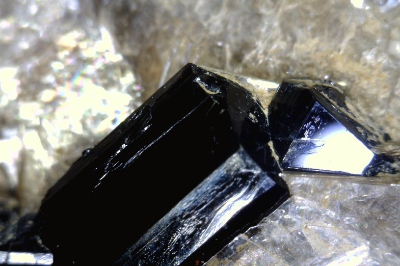


Sturtevant Quarry, Minot, Androscoggin County, Maine, USA