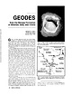
 | | Journal (article/letter/editorial) | | 07 January 2015 from the Warsaw Formation of Missouri, Iowa, and Illinois ARTHUR E. SMITH 9118 Concho...limestones of the lower Warsaw Formation where Missouri, Iowa, and Illinois adjoin each other along the...I was a graduate student at the University of Missouri in the late 1950s and have fond memories of several...several of us rushing north from Columbia, Missouri, to the geode area in the late winter-early spring...& MINERALS Van Buren ' I It Clark County LewisCounty MISSOURI b f $ x X x xx L.& -.L .-.- |  | | Journal (article/letter/editorial) | | road cut along old IN-37, near Harrodsburg, Monroe County, Indiana. Note the semispherical opening, lower...and the Warsaw Formation in Illinois, Iowa, and Missouri. Geodes occur primarily in limestones that can...from a commercial geode mine at St. Francisville, Clark County, Missouri. This specimen appeared on the...quartz geode, from a locality near Revere, Clark County, Missouri. Cincinnati Museum Center specimen (No...Sheffler’s geode mine, near Alexandria, Clark County, Missouri. Fred and Sue Keitel specimen, Terry Huizing |  | | Journal (article/letter/editorial) | | GEODE F I E L D T R I P S T O ST. F R A N C I S V I L L E , MO., A N D GEODE M I N E K E O K U K , I... geodes acquired ownership of the famous St. Francisville geode mine for the purpose of opening the...permitted the oppor tunity of digging the classic St. Francis ville geodes. Even though the mine is open...cost to the participants. The geodes from St. Francisville are known the world over as the finest specimens...barrel calcite crystals on smoky quartz-lined geodes. St. Francis ville is also the only known location to |  | | Journal (article/letter/editorial) | | SHERWOOD 106A East 25th, P. 0. Box 436 Oak Grove, Missouri 64075-0436 Downloaded by [Brown University Library]...549 Aqua Ridge Drive St. Louis, Missouri 63129-2704 Figure 1. Counties in Missouri. N o comprehensive...comprehensive list of Missouri mineral occurrences has been published since Leonhard (1 882), updated by Wheeler...found in Missouri; two of these, fletcherite and starkeyite, were first described from Missouri mines....location a~ included at the end of each entry. Adair County Chariton River (40-04-05N 92-4 I -23W). septarian |  | | Journal (article/letter/editorial) | | Missouri VISIT0 R INFORMAT1ON Compiled by WILLIS D. SMITH 1413 N. Elizabeth Avenue Calverton Park, Missouri...basically divided into two distinct regions by the Missouri River. The northern part of the state was covered...visit; for more specific information, write the Missouri Division of Tourism, Truman State Office Building...GEOLOGIC INTEREST State Parks and Historic Sites Missouri has forty-six state parks and thirty-three historic...geologic feature, State parks are managed through the Missouri Department of Natural Resources, Division of State |  | | Book (volume) | | Dahlonega Co. and Rabum Co., and the McDuffie County Belt extending through portions of McDuffie, Warren...Sphalerite. BALDWIN COUNTY MILLEDGEVILLE, at state farmjasper. BANKS COUNTY COMMERCE, along Hwy. 59...along adjoining Co. linerock crystal. BARROW COUNTY WINDER, along rd. to Jefferson and 1½ mi. inside...Guide for Rock Hounds in the United States BARTOW COUNTY AREA, Saltpeter Cave, as floatjasper. CARTERSVILLE:...agate, (banded, various colors), jasper. BIBB COUNTY MACON: at Holton Quarry, 7½ mi. NWagate; N |  | | Book (volume) | | 600 to 800 feet thick in the north. ALEXANDER COUNTY FAYVILLE, area stream gravels⎯agate, jasper, rare...⎯agate, jasper; d RR siding of Clay⎯agate. CALHOUN COUNTY AREA, shores of the Mississippi R., in the Warsaw...crystals). CRAWFORD COUNTY PALESTINE, area deposits⎯Siderite. EDWARDS COUNTY AREA, T. 1 S, R. 10 E...E, regional deposits⎯Siderite. FULTON COUNTY FARMINGTON, W 6 mi. on Rte. 116 to the Rapatee No. 5 strip...mine⎯pyritized gastropods (Pennsylvanian age). GRUNDY COUNTY AREA: c Regional rd. and RR cuts and banks of Mason |  | | Book (volume) | | 600 to 800 feet thick in the north. ALEXANDER COUNTY FAYVILLE, area stream gravels⎯agate, jasper, rare...⎯agate, jasper; d RR siding of Clay⎯agate. CALHOUN COUNTY AREA, shores of the Mississippi R., in the Warsaw...crystals). CRAWFORD COUNTY PALESTINE, area deposits⎯Siderite. EDWARDS COUNTY AREA, T. 1 S, R. 10 E...E, regional deposits⎯Siderite. FULTON COUNTY FARMINGTON, W 6 mi. on Rte. 116 to the Rapatee No. 5 strip...mine⎯pyritized gastropods (Pennsylvanian age). GRUNDY COUNTY AREA: c Regional rd. and RR cuts and banks of Mason |  | | Book | | tourmaline crystals from various mines in San Diego County, California are often found distinctively zoned...polished “egg” from the Chocolate Mountains, Imperial County, California. The scenic features are simply the...sta/actitic form. This lustrous, translucent aragonite stalactite is 10” long and is colored a strong...crystal-lined pocket, or vug, ina mine at Tintic, Juab County, Utah in the late thirties. It is a choice specimen...Switzerland; stibnite in quartz, Manhattan, Nye County, Nevada. Inclusion specimens may be very attractive |  | | Journal (issue) | | end. The states of Iowa, Illinois, Indiana and Missouri furnish us with the best examples of the well...square miles in Iowa, and 400 square miles in Missouri, or a total of 4,500 square miles. I will now...Bands of chert and amorphous 1. | CHESTER BEDS. St. Louis LIMESTONE . geodes, in shale and argillaceous...-Carboniferous is divided as follows : Chester Group .. St. Louis Group . Keokuk Group Burlington Limestone...Keokuk limestone is to be seen ; geologically, Lee County appears thus : Alluvium. Drift or Boulder .. Coal |  | | Journal (issue) | | off for the four wheel drive road that goes to Missouri hill. A couple of miles up we discovered that...eruptive rocks from the CCVF cover an area of Park County. approximately 8500 sq. mi. including most of the...field trip headed south from Hartsel on CO 9 and County 53 Rd and noted the Antero Formation of Oligocene...further south to the club peridot claim located near County Rd. 53, The gemmy olivine comes from a rock unit..., L. A., Geology and Mineral Resources of Park County, Colorado: Colorado Geological Survey, Resource |  | | Journal (article/letter/editorial) | | 5 2 Street, New Britain, Conn. 0 6 0 5 1 . Over St., Brooklyn, N . Y . 11203 101 fluorescent minerals...hackmanite, fluorite, calcite, opal, sphalerite, aragonite, manganapatite, sodalite; Twelve l x i " for $5...0 Postpaid U.S.A. Harold W . Bower, 4 4 2 Reagan St., S u n bury, Pa. 17801 CATALOGS SENT O N REQUEST...Take Rt. 2 2 4 west 1 mile from Interstate 7 5 and County Road 140 north V i mile. FILL YOUR Mexican ...postage. Street, Dailey Canandaigua, Studio, Clark 164 New York. 14424 Ton grade Mexican agate; |  | | Journal (article/letter/editorial) | | catalog at our new address. Stolove's, 5 2 2 E. 5 2 St., Brooklyn, N. Y . 11203 FOSSILS, A R T I F A C...beautifully trated. Send $ 3 . 5 0 to: Gerard R. 2 2 5 St. Pauls Avenue, Jersey City, Jersey. 0 7 3 0 6 1 18...Alabama Paleontological E n terprises, 102 Cook St., Gadsden, A l a bama. 35901 500 M I L L I O N...(re fundable) . House of Brilliance, 6 3 Dwight St., New Britain, Conn. 0 6 0 5 1 . T e l . (203) 225-3426...hackmanite, fluorite, calcite, opal, sphalerite, aragonite, manganapatite, sodalite; Twelve l x l " for $ |  | | Journal (article/letter/editorial) | | beautifully trated. Send $ 3 . 5 0 to: Gerard R . 2 2 5 St. Pauls Avenue, Jersey City, Jersey. 0 7 3 0 6 Fossil...catalog at our new address Stolove's. 5 2 2 E . 5 2 St., Brooklyn, N . Y . 1 1 2 0 3 FOSSILS, A R T I F...stamp for price list. K . Frazier, 4 5 6 4 3 2 n d St., San Diego, Calif. 9 2 1 16 46 U L T R A V I O...r e fundable) . House of Brilliance, 6 3 Dwight St., N e w Britain, Conn. 0 6 0 5 1 . T e l . (203)...hackmanite, fluorite, calcite, opal, sphalerite, aragonite, manganapatite, sodalite; T w e l v e 1 x 1 " |  | | Journal (article/letter/editorial) | | stamp for price list. K . Frazier, 4 5 6 4 3 2 n d St., San Diego, Calif. 9 2 1 16 FOSSILS F O S S I L...catalog at our new address. Stolove's, 5 2 2 E . 5 2 St., Brooklyn, N . Y . 1 1 2 0 3 FOSSILS, A R T I F...recommended). A r t h u r W . Tomlinson, 4 3 5 Pine St., Elmira, N . Y . 1 4 9 0 4 (Also see my slab ad)...r e fundable) . House of Brilliance, 6 3 Dwight St., N e w Britain, Conn. 0 6 0 5 1 . T e l . (203)...Take Rt. 2 2 4 west 1 mile from Interstate 7 5 and County Road 140 north Vi mile. M I C R O M O U N T S |  | | Book (volume) | | specific locations in Idaho, lowa, Kansas, Minnesota, Missouri, Montana, Nebraska, North Dakota, — ; Oregon...NORTHWESTERN QUANDRANT Idaho, Iowa, Kansas, Minnesota, Missouri, Montana, Nebraska, North Dakota, Oregon, South...Northwestern Quadrant Idaho, Iowa, Kansas, Minnesota, Missouri, Montana, Nebraska, North Dakota, Oregon, South...Location Numbers Idaho lowa Kansas Minnesota Missouri Montana Nebraska North Dakota Oregon South Dakota...volumes, through very precise directions and accurate county maps, to get you to the best and most accessible |  | | Journal (issue) | | The walls of the quarry are Salem Limestone and St. Louis Limestone. Below the Salem Limestone is the...article ·'Geodes from the Warsaw Formation of Missouri, Iowa, and Illinois.'· Rocks and Minerals, Volume...is not as strong as the green fluorescence of aragonite.'· I decided to try to find out how common barrel...the recent construction along Missouri highway 61 in Lewis County Missouri or at fee collecting sites around...KeoJ...'Uk area geodes. "I have only seen it from St. FrancisYille and possibly, rarely from Scheffler's |  | | Journal (article/letter/editorial) | | stamp for price list. K . Frazier, 4 5 6 4 3 2 n d St., San Diego, Calif. 9 2 1 16 FOSSILS FOSSILS — 1...catalog at our new address. Stolove's, 5 2 2 E . 5 2 St., Brooklyn, N . Y . 1 1203 FOSSILS, A R T I F A...recommended) . A r t h u r W . Tomlinson, 4 3 5 Pine St., Elmira, N . Y . 1 4 9 0 4 (Also see my slab a d...r e fundable) . House of Brilliance, 6 3 Dwight St., N e w Britain, Conn. 0 6 0 5 1 . T e l . (203)...e Rt. 2 2 4 west 1 mile from Interstate 7 5 and County Road 140 north V2 mile. M E X I C A N C U T T |  | | Book (volume) | | Florida Georgia Kentucky Louisiana Mississippi Missouri North Carolina South Carolina Tennessee Virginja...exclusively i.n the Blue Ridge Mountains of Mitchell County, North Carolina, to be true hiddenite. Preface...discounts for senior . Directions: Anniston, in Calhoun County, is 60 miles northea t of Birmingham and 80 miles...pine-covered acres along the banks of the Little Missouri River. The first diamond was found in ] 906; the...its way through the woods to the scenic little Missouri River.This provides a relaxing!-hour hike over |  | | Report (issue) | | ............................................ Aragonite ................................................white calcite crystals on light brown calcite. C. Aragonite in shells. D. White to colorless, columnar barite...... B. Nodule of "coldwater agate" from Benton County showing gray and white chalcedony and crystalline...made from "coldwater agate" material of Keokuk County..................................................Another variation of "coldwater agate" from Keokuk County. C. Quartz geode. D. Doubly terminated quartz crystals |  | | Book (edition) | | MARIN COUNTY FREE LIBRARY 3 1111 00289 4184 \ I s Fifth Revised Edition A complete, state-by-state...From such formations come the sapphires in the Missouri River near Helena, Montana, and the star garnets...corners of the claimed area, and filing in the county land agent's office. In addition he has to show...called bediasites from Bedias, a town in Grimes county. Gold is a subject by itself, but because the gem...(Continued) Name and Hard- Specific Gravity ness Aragonite 3.5 Composition Color or Pattern Calcium |  | | Book (volume) | | Published by Hobbit Press 2435 Union Road St. Louis, Missouri 63125 first printing December, 1996 ii.............................................255 Missouri................................................................548 Table of Maps Page Alabama County Map ...................................................................................4 Alaska County and Stream Map ......................................................................22 Arizona County Map .......................................... |  | | Book | | HfiRIN COUNTY FREE LIBRfiRY 311110G386652Q I V Russell P MacFal A COLOR TREASUF FOR COLLECTORS...to Hunting Locations ? i 9 GIVEN TO THE MARIN COUNTY LIBRARY BY MARI N L MTNF.RAT. SOCTETY DAVID...may be able to buy specimens. map of Keweenaw County. Mich- Part of the U.S. Geological Survey topographic...form, the less common calcium carbonate called aragonite, and its famous pseudohexagonal twins from the...Photographs 1 of Twin Crystals. Calcite. 2 Aragonite, a pseudohex- agonal twin. Spain. 3 Sanidine |  | | Book (volume) | | NORTHWESTERN QUADRANT Idaho, Iowa, Kansas, Minnesota, Missouri, Montana, Nebraska, North Dakota, Oregon, South...volumes, through very precise directions and accurate county maps, to get you to the best and most accessible...for the county in which it is located. This site number also appears under the given county in the text...the heading of Arizona, on the map of Maricopa County, the site x How to Use This Book indicated...21, corresponds to the number on the cor- rect county map; in the directions, the first portion—Tonropah |  | | Book (edition) | | describes sites under of the nearest town and county. and the many maps included book contain such...From such formations come the sapphires in the Missouri River near Helena, Montana, and the star rocks...North Carolina. in the U. S. can be found the Missouri River below Helena, SAPPHIRES in Montana, and...pink hue (right) from the Sunnyside Mine, San Juan County, Colorado. MOTTLED AGATE from Chihuahua, Mexico...usually veined with black. This is from Siskiyou County, California. z'^m-: LABRADORITE, the feldspar |
|


