Goodwin Dam (Hogback Dam), Hartland, Hartford County, Connecticut, USAi
| Regional Level Types | |
|---|---|
| Goodwin Dam (Hogback Dam) | Dam |
| Hartland | City |
| Hartford County | County |
| Connecticut | State |
| USA | Country |
This page is currently not sponsored. Click here to sponsor this page.

Latitude & Longitude (WGS84):
41° 59' 22'' North , 73° 1' 11'' West
Latitude & Longitude (decimal):
Type:
Köppen climate type:
Nearest Settlements:
| Place | Population | Distance |
|---|---|---|
| Winsted | 7,712 (2017) | 8.3km |
| New Hartford Center | 1,385 (2017) | 12.7km |
| Winchester Center | 10,830 (2017) | 13.8km |
| Norfolk | 553 (2017) | 15.1km |
| Granville | 1,548 (2017) | 15.6km |
Nearest Clubs:
Local clubs are the best way to get access to collecting localities
Local clubs are the best way to get access to collecting localities
| Club | Location | Distance |
|---|---|---|
| Bristol Gem & Mineral Club | Bristol, Connecticut | 36km |
| Connecticut Valley Mineral Club | Springfield, Massachusetts | 38km |
Mindat Locality ID:
266806
Long-form identifier:
mindat:1:2:266806:5
GUID (UUID V4):
25a582ab-384f-4af0-b645-d66800f9e387
In 1955, the Metropolitan District Commission completed the Goodwin Dam constructed at a narrow gorge on the West Branch of the Farmington River known as “The Hogback” (which lent its name informally to the dam), just east of the Colebrook town line in the town of Hartland. It was created for a drinking water reservoir (West Branch Reservoir) and is downstream from the later (1969) Colebrook River Dam constructed by the US Army Corps of Engineers for flood control (Colebrook River Lake). The Goodwin Dam is underlain by Proterozoic hornblende gneiss, and this local rock was presumably blasted for use at the dam.
Select Mineral List Type
Standard Detailed Gallery Strunz Chemical ElementsDetailed Mineral List:
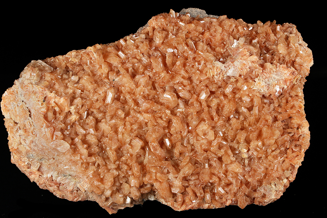
| ⓘ Stellerite ? Formula: Ca4(Si28Al8)O72 · 28H2O Habit: tabular prisms Colour: orange Description: Crystals to 1 cm coating brecciated gneiss. A sample https://www.mindat.org/photo-709453.html analyzed by SEM-EDS determined to be most likely stellerite because of total lack of Na and K. References: |
| ⓘ 'Stilbite Subgroup' Formula: M6-7[Al8-9Si27-28O72] · nH2O Habit: tabular prisms Colour: orange Description: Crystals to 1 cm coating brecciated gneiss. References: |
Gallery:
List of minerals arranged by Strunz 10th Edition classification
| Group 9 - Silicates | |||
|---|---|---|---|
| ⓘ | Stellerite ? | 9.GE.15 | Ca4(Si28Al8)O72 · 28H2O |
| Unclassified | |||
| ⓘ | 'Stilbite Subgroup' | - | M6-7[Al8-9Si27-28O72] · nH2O |
List of minerals for each chemical element
| H | Hydrogen | |
|---|---|---|
| H | ⓘ Stellerite | Ca4(Si28Al8)O72 · 28H2O |
| H | ⓘ Stilbite Subgroup | M6-7[Al8-9Si27-28O72] · nH2O |
| O | Oxygen | |
| O | ⓘ Stellerite | Ca4(Si28Al8)O72 · 28H2O |
| O | ⓘ Stilbite Subgroup | M6-7[Al8-9Si27-28O72] · nH2O |
| Al | Aluminium | |
| Al | ⓘ Stellerite | Ca4(Si28Al8)O72 · 28H2O |
| Al | ⓘ Stilbite Subgroup | M6-7[Al8-9Si27-28O72] · nH2O |
| Si | Silicon | |
| Si | ⓘ Stellerite | Ca4(Si28Al8)O72 · 28H2O |
| Si | ⓘ Stilbite Subgroup | M6-7[Al8-9Si27-28O72] · nH2O |
| Ca | Calcium | |
| Ca | ⓘ Stellerite | Ca4(Si28Al8)O72 · 28H2O |
Other Regions, Features and Areas containing this locality
North America PlateTectonic Plate
- Laurentides DomainDomain
This page contains all mineral locality references listed on mindat.org. This does not claim to be a complete list. If you know of more minerals from this site, please register so you can add to our database. This locality information is for reference purposes only. You should never attempt to
visit any sites listed in mindat.org without first ensuring that you have the permission of the land and/or mineral rights holders
for access and that you are aware of all safety precautions necessary.


Goodwin Dam, Hartland, Hartford County, Connecticut, USA