York Road Quarry, Egmont National Park, Stratford District, Taranaki Region, New Zealandi
| Regional Level Types | |
|---|---|
| York Road Quarry | Quarry |
| Egmont National Park | National Park |
| Stratford District | District |
| Taranaki Region | Region |
| New Zealand | Country |
This page is currently not sponsored. Click here to sponsor this page.

Latitude & Longitude (WGS84):
39° 17' 12'' South , 174° 10' 53'' East
Latitude & Longitude (decimal):
Locality type:
Köppen climate type:
Nearest Settlements:
| Place | Population | Distance |
|---|---|---|
| Egmont Village | 479 (2014) | 16.1km |
| Kaponga | 357 (2011) | 16.5km |
| Eltham | 2,235 (2011) | 18.8km |
| New Plymouth | 49,168 (2011) | 25.9km |
| Okato | 528 (2011) | 27.4km |
A former quarry worked for gravel for roads and railways.
Located at the end of York Road which leaves State Highway 3, at one kilometre north of Midhurst. The road ends at the base of Mount Taranaki's east side, the mine now within the Egmont National Park.
The quarry opened in 1908, with a railway line, crusher, and housing, producing around 25,000 tonnes of rock per year for road metal, port breakers, and railway ballast. Operations began to decrease from 1928, until finally closed in 1951. All the processed material was extracted from the nearby river bed.(updated 2020)
At the car park is a railway wagon, and a 2 hour loop trail, with information boards, visiting the bunkhouse and cottage sites, crusher site, water pipelines, railway remnants, a still complete sand trap which filters water for the crusher turbines, railway yard clearing, and quarry.
The new York Rd Quarry is situated on the same access road to the old quarry but is outside of the park boundary and processes ground deposits of andesite.
Select Mineral List Type
Standard Detailed Gallery Strunz Chemical ElementsCommodity List
This is a list of exploitable or exploited mineral commodities recorded at this locality.Mineral List
1 valid mineral.
Rock Types Recorded
Note: data is currently VERY limited. Please bear with us while we work towards adding this information!
Select Rock List Type
Alphabetical List Tree DiagramDetailed Mineral List:
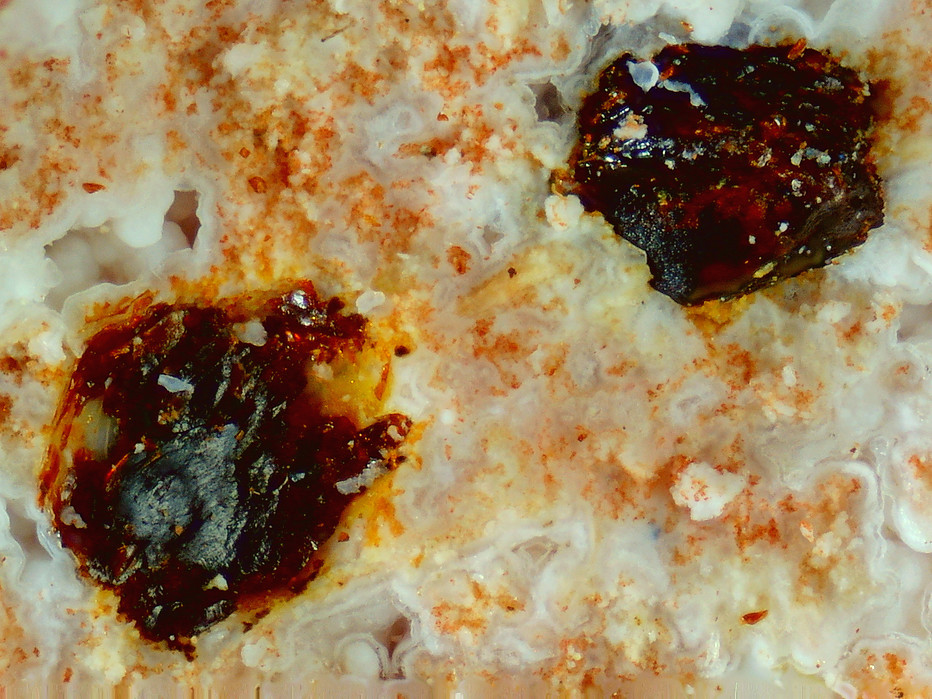
ⓘ 'Limonite' Reference: Collection of RJ Martin |
| ⓘ Opal Formula: SiO2 · nH2O Reference: Collection of RJ Martin |
ⓘ Opal var. Hyalite Formula: SiO2 · nH2O Reference: Collection of RJ Martin |

Gallery:
List of minerals arranged by Strunz 10th Edition classification
| Group 4 - Oxides and Hydroxides | |||
|---|---|---|---|
| ⓘ | Opal | 4.DA.10 | SiO2 · nH2O |
| ⓘ | var. Hyalite | 4.DA.10 | SiO2 · nH2O |
| Unclassified Minerals, Rocks, etc. | |||
| ⓘ | 'Limonite' | - | |
List of minerals for each chemical element
| H | Hydrogen | |
|---|---|---|
| H | ⓘ Opal var. Hyalite | SiO2 · nH2O |
| H | ⓘ Opal | SiO2 · nH2O |
| O | Oxygen | |
| O | ⓘ Opal var. Hyalite | SiO2 · nH2O |
| O | ⓘ Opal | SiO2 · nH2O |
| Si | Silicon | |
| Si | ⓘ Opal var. Hyalite | SiO2 · nH2O |
| Si | ⓘ Opal | SiO2 · nH2O |
References
Sort by
Year (asc) Year (desc) Author (A-Z) Author (Z-A)Department of Conservation, York Road Loop Track pamphlet, Egmont National Park, Taranaki Area.
External Links
Other Regions, Features and Areas containing this locality
This page contains all mineral locality references listed on mindat.org. This does not claim to be a complete list. If you know of more minerals from this site, please register so you can add to our database. This locality information is for reference purposes only. You should never attempt to
visit any sites listed in mindat.org without first ensuring that you have the permission of the land and/or mineral rights holders
for access and that you are aware of all safety precautions necessary.


York Road Quarry, Egmont National Park, Stratford District, Taranaki Region, New Zealand