 | | Report (Issue volume) |
| these card catalogues would be as useful to the mining industry as they have proved to be to the Division...and expense involved are justified and that the mining industry will find that having this material readily...accumulating steadily since 1853, when the first mine (a coal property) was developed. Actually it antedates...During the 90 years or more that prospecting and mining have been active, a vast amount of information...extensively to the fund of published data. Also, mining journals and periodicals, many of which are no |
 | | Report (issue) |
| . . . . . . . . . . . . . . . . . 1 Chapter I. Mining Districts of Counties and the State of Utah. .... . . . . . . . . . . . . . . . . . . . . . . 1 County Listings. . . . . . . . . . . . . . . . . . . ... . . . . . . . . . . . . . . . . 1 Chapter II. Mining Districts of Utah . . . . . . . . . . . . . . .... . . . . . . . 4 Mineral Localities Listed by County . . . . . . . . . . . . . . . . . . . . . . . .... . . . . . . . . . . . . . . . . . . 7 Beaver County . . . . . . . . . . . . . . . . . . . . . . . |
 | | Report (volume) |
| ...................................... Tertiary lake beds ............................................................................. 50 History of mining............................................................................ 54 Condition of the mining industry.................................................................. 56 Nespelem (Moses) district............................................. ............................... 58 Production and mining conditions. ................................. 59 |
 | | Journal (article/letter/editorial) |
| Western side of Stapleton Gulch in the Argenta district. The Stapleton workings are visible in the lower...of the center below the crest of the hill. in Montana Unless otherwise noted, all photographs by the... CHRISTOPHER S. TUCKER PO Box 22575 Billings, Montana 59104 tuckerj@mcn.net W ith the variety of colors...wulfenite; however, they seldom have specimens from Montana in their collections. When one thinks of wulfenite...mountains of western Montana. Figure 1. Wulfenite, with vanadinite, 8 mm across, Blackhawk mine, Radersburg district |
 | | Journal (article/letter/editorial) |
| Montana Mineral Locality Index Downloaded by [University of Nebraska, Lincoln] at 20:00 09 April 2015...2015 K NOWN AS THE TREASURE STATE, Montana is rich in mineral and gemstone localities. The state motto...with its representation of mining tools clearly proclaim Montana’s mining origins. Montana’s production...published describing the occurrence, collecting, mining, and cutting of the two state gemstones. Figure...2. Granville Stuart established Montana’s first mining camp at Gold Creek in 1860. Geologic Provinces |
 | | Report (issue) |
| _.......................... . Situation of the district. ....... ____ . __ .. __________ ................ _. ___ ....... _..... _... _..... __ .. The district. __ ... ____ .... __ ... ___ ... ___ .. ____ .... _. __ ..... __ . _.. __ ...... . History o.f mining .. ___ .. ______ .... _. ________________ . __...____ .... _____ .. CHAPTER IV.-Structnre of the district. ................... _............. _....... __....... _____ . _____ . General structure of the district ......... _....... _............. _... ___ .. |
 | | Report (volume) |
| BUIJLETIN 528 GEOLOGY AND ORE DEPOSITS 1 OF LEMHI COUNTY, IDAHO BY JOSEPH B. UMPLEBY WASHINGTON GOVERNMENT...and animal life....................----.-----.....Mining......................................................................................... Miocene lake beds......................................... Distribution...............;............ Extent of the Miocene lake............................ Quaternary system............................ 74 Mineralogy of Lemhi County ores....................................... 74 |
 | | Report (issue) |
| in H>OO and incorporated in 1904 as the Windfall Mining Company. The formations as exposed on the ' The...ropo1-ted from the ore. u. s. COPPEn-oor_,n_ This mine is situated in sec. 17, T. 32 N., R. 41 E. TJiere...Geological SU-rvey CHEWELAH CONSOLIDATED. This mine is situated in the northern pa.rt of sec. 25, T...north- ern extension of the Chewelah argillites. The mine is located 011ly a short distance east of the .Addy...formations have been cut off by intrusions of the Loon Lake granite. The strata have been greatly di sturlJed |
 | | Journal (issue) |
| crystals $3,500 - Calaveras County, Calif. GOLD on Quartz—$1,400 Crystal Mine, Angels Camp, Calif. GOLD—1...crystals $3,200 - Ma dera County, Calif. GOLD on Quartz—$2,750 Crystal Mine, Angels Camp, Calif. KRISTALLE.............. 28 by Peter B. Leavens The Bluebell Mine, Riondel, British Columbia, Canada................38 by Wendell E. Wilson and John S. White, Jr. Mining Claims for the Mineral Collector.................years are up we just have someone push you off a cliff.” The issue after next will be our long-awaited |
 | | Report (issue) |
| MINING IN THE LOWER COPPER RIVER BASIN, By FRED H. MOFFIT. COPPER MINING IN CHITINA VALLEY. INTRODUCTION...activity of the copper market is reflected in the district by increased interest in prospecting for copper...are described in detail.. The copper ores of the district extending from Kotsina River to Nizina are chiefly...overlying the lava flows. The Kennecott-Bonanza and Jumbo mines are the best known of such deposits, and because...the principal metal that has been sought in this district, silver has been found at one locality, where |
 | | Report (issue) |
| MINING IN SOUTHEASTERN ALASKA. By CHARLES W. WEIGHT. INTRODUCTION. The year 1908 has marked but little...little advance in the mining industry of southeastern Alaska as compared with previous years. At some of...of the gold mines in the Juneau district the Treadwell group and the Perseverance and Eagle River mines...mines a substantial gain was made and extensive mining and water-power projects have been undertaken which...during 1909. The copper mines of the Ketchikan district, on the other hand, have suffered a considerable |
 | | Report (volume) |
| __________----_______-______-_--_------.__-__ History of mining and production__.._______.______.___.__-___-_____..._____________________________________ Garfield County..______________________________________ Fullmer...Descriptions of individual deposits Continued Juab County._______________,.___-__-_____-____--___-_-___-____...Boy group)_-____--_-_____. Guy group (Black Jack mine)_____-_-___-,-_-___-____-._ Last Chance property....__-_____-____-_______---___-___. Black Diamond mine. _________________-_^-_-_--_---.__ Martha prosp |
 | | Journal (article/letter/editorial) |
| noted Figure 1. Camp Bird mine, level 2, Sneffels district, Ouray County. Raines-Pettem collection,...from the Leadville district, with another 50 million pounds mined in San Juan County (Henderson 1926).... During the twentieth century, the Gilman district surpassed Leadville in total copper production with...million pounds (Del Rio 1960). By comparison, Butte, Montana, produced more than 266 million pounds of copper...the Eagle mine’s (Gil304 ROCKS & MINERALS man district) production. This does not mean that copper has |
 | | Report (volume) |
| buildings at Kennecott, Alaska. The Kennecott district Cu-Ag mines in the Wrangell Mountains were some...to 1938. See deposit description for Kennecott district (number 30 for southern Alaska). Copyrighted drawing...Department of Geology, University of Montana, Missoula, Montana Helen L. Foster, U.S. Geological Survey...Francisco, California Brian K. Jones, Bear Creek Mining, Kennecott Corporation, Anchorage, Alaska Ian M...Department of Geology, University of Montana, Missoula, Montana Christopher D. Maars, Anaconda Minerals |
 | Nokleberg, W.J., Bundtzen, T.K., Berg, H.C., Brew, D.A., Grybeck, Donald, Robinson, M.S., Smith, T.E., Yeend, W.E. (1988) Metallogeny and major mineral deposits of Alaska. Open-File Report Vol. 1988 (88-73) US Geological Survey doi:10.3133/ofr8873 | Report (issue) |
| Department of Geology, University of Montana, Missoula, Montana Helen L. Foster, U.S. Geological Survey...Francisco, California Brian K. Jones, Bear Creek Mining, Kennecott Corporation, Anchorage, Alaska lan M...Department of Geology, University of Montana, Missoula, Montana Christopher D. Maars, Anaconda Minerals...and Wrangell Mountains ........ 35 Willow Creek District, Talkeetna Mountains ...........................Massive Sulfide Deposits, Prince William Sound District, Chugach Mountains .......................... |
 | | Report (issue) |
| description of the geology, mining history, and production of the major gold-mining districts in 21 States...relations ---------------------------History of gold mining and trends in production_ J\labama -----------...--------------Cleburne County ----------~----------------- Tallapoosa County --------------------------Alaska...------------------Cochise County -----------------------------Gila County --------------------------------Greenlee...ee County ----------------------------R[aricopa County ----------------------------R[ohave County -- |
 | | Report (issue) |
| geographic coordinates and, where applicable, by county and section, township, and range. Both published...nickel-plus-copper in the deposit. The Gap mine (Pennsylvania) and the San Julian mine (California),are examples of...deposits varies widely. Some, like the Bluebird mine (Arizona), are small deposits containing 16 mostly...mostly only cobalt minerals. At the Standard mine (Oregon), the , cobalt minerals are associated with...present in separate ore shoots. In the Blackbird district (Idaho), the amount of copper present is greater |
 | | Report (issue) |
| . . . . . . . . . . . . . . . . . . . Stevens County..................... ... . . . . . . . . . . ....Northport District. .... . ........ . .. ... . . . .. . . . ............ . Myers Fa.Us District . . . .... . . . . . . . . . . . . . . . . Fla.t C1·eek District . . . . . . . . . . . . . . . . . . . . . . .... . . . . . . . . . . . . . . . . . Colville District . . . . . . . . . . . . . . . . . . . . . . . ..... . . . . . . . . . . . . . . . . . Chewela.h,District . . . . . . . . . . . . . . . . . . . . . . . |
 | | Report (issue) |
| Topography, Geology and Mineral Resources.. Douglas County— Location and Topography.. Geology and Ore Deposits...Highways_____ Production............................... Mining Districts— Buckskin (Smith Valley). Gardnerville...Nut)............................ Red Canyon (Silver Lake)......... PUBLISHED QUARTERLY BY THE Wellington...Glance)..... U n iv e r s it y o f N e v a d a irmsby County— RBNO, NEVADA Location and Topography............ Nevada, as second-class m atter under A rt of Mining Districts— Congress, July 16, 1894. Acceptance |
 | | Journal (article/letter/editorial) |
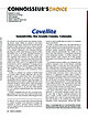
| November 2014 Covellite Summitville, Rio Grande County, Colorado Two minerals are typically formed when...periods when some chance discovery in an active mine makes them briefly available to collectors. Chalcocite...pseudomorphs after covellite are well known from Butte, Montana. A comprehensive description of the fundamental...such localities as the Loudville mine, Easthampton, Hampshire County, Massachusetts; Mineral Hill, WakeFigure...aesthetic specimen from the East Colusa mine, Butte, Montana, consisting of sharply developed, thin covellite |
 | | Report (issue) |
| age, as mapped by Moffit 1 in the Chistochina district. » Moffit, F. H., U. S. Geol. Survey Bull. 498...dikes that cut the platinum-bearing conglomerates. MINING. The output of gold on Slate Creek in 1917 is...to bring about. In 1917 the principal productive mining was on Slate Creek, where two hydraulic plants...a number of outfits were mining on a small scale. The M. E. W. Gold Mining Co., operated by J. M. Elmer...interfered with the work. Besides the productive mining on Slate Creek, assessment and development Work |
 | | Report (volume) |
| FREDERICK LESLIE RANSOME NOTES ON THE MANHATTAN DISTRICT G. H. GARREY AND W. H. EMMONS WASHINGTON GOVERNMENT..................................... Gold field district............................................................................................... Mining development..................................................................................... Mine maps......;........................................ 20 22 22 22 25 25 28 34 37 38 39 Bullfrog district.............. ............................... |
 | | Report (volume) |
| ______________________________________ Chandler Lake quadrangle_-_______-___-______________________ Charley...quadrangle._________________________________________ 153 Lake Clark quadrangle......_________________________________...as, for example, Saltchuck and Salt Chuck. If a mine and an operator have the same name except for a...additional words appear in parentheses after the mine name, as, for example, Nabesna (Min. Corp.). COORDINATE...stream on which there has been extensive placer mining), coordinates include the extreme limits of the |
 | | Report (volume) |
| ___________________________________ 70 Flyder district -----------------------------------------------VValker...prospect (P-4) ---------------------------------Lake prospect (P-5) ---------------------------------------Lakeside...-------------------------------------Lower Basin (Jumbo area) (P-13) -------------------------Upper Basin...prospect (P-15) ---------------------------------Galena prospect (P-16) -----------------------------------Goat...___ __ 4 2-8. Photographs of: 2. Glacier-carved cliff, Punchbowl Cove __________________ 5 6 3. Glacially |
 | | Book |
| milky quartz stems. Denny Mountain area of King County. Specimen from the collection of Cary A. Maykut...DESCRIPTIONS 21 ABBREVIATIONS 24 GLOSSARY 25 COUNTY INDEX OF MINERAL OCCURRENCES 29 MINERAL DESCRIPTIONS...(using a code explained on page 21) and a county by county list mentioning the nature of their occurrence...Parks and Monuments prohibit all collecting. state, county and city parks usually prohibit collecting. Please...etc. 5 c. SULPHIDE LENSES IN CARBONATE ROCKS Galena, marcasite, sphalerite, calcite, quartz, barite |


