 | | Journal (article/letter/editorial) | | Houston, Texas 77036 ROBERT 0. FAY Oklahoma Geological Survey Norman, Oklahoma 73019 Downloaded by [The Aga...713 15th Street NW Ardmore, Oklahoma 73401 OKLAHOMA Figure 1. Oklahoma counties. Mineral Locality...known for its gypsum crystals and barite roses, Oklahoma also boasts a variety of other species, including...unaware of the variety of minerals available from Oklahoma and think primarily of the prolific gypsum crystals...hundred years, extends into the northeast corner of Oklahoma and has produced notable specimens. Unfortunately | 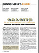 | Huizing, Terry E., Richards, R. Peter, Clifford, Janet H., Cook, Robert B. (2017) Connoisseur's Choice: Calcite from the American Midwest, Gordonsville Mine, Carthage, Smith County, Tennessee. Rocks & Minerals, 92 (1) 46-63 doi:10.1080/00357529.2017.1241690 | Journal (article/letter/editorial) | | from the American Midwest Gordonsville Mine, Carthage, Smith County, Tennessee C alcite is ubiquitous...well-crystallized minerals as barite, fluorite, galena, and sphalerite. Calcite crystals are classic components...collector for more than forty years, she enjoys field trips, exhibiting at mineral shows, volunteering...the Gordonsville mine, Central Tennessee Lead-Zinc district near Carthage in Smith County. Calcite from...cm tall, from the Ben Hogan quarry in Lawrence County, Arkansas. Terry Huizing specimen (No. TEH 273) |  | | Journal (issue) | | The Tri-State Mining District Missouri-Kansas-Oklahoma by Denise Bicknell Wendell E. Wilson 2017 The...Advertising Manager Thomas P. Moore COVER: CALCITE on GALENA and dolomite, 19 cm, from Webb City, Missouri....Peter L. Via Salim Edde Daniel Trinchillo Lyda Hill Scott A. Rudolph Daniel J. Record Gail & Jim Spann Rob...Tucson USA Visit us at these international shows: Houston Ste. Marie Denver Munich USA France USA Germany...and Riverpark Inn Rhodochrosite, Sweet Home Mine, USA, 10 cm Photo: Malte Sickinger MARCUS BUDIL Monaco |  | | Report (issue) | | Geology and Ore Deposits of the Picher Field Oklahoma and Kansas GEOLOGICAL SURVEY PROFESSIONAL PAPER... 588 Geology and Ore Deposits of the Picher Field Oklahoma and Kansas By EDWIN T. McKNIGHT and RICHARD...4. Map showing towns and mine workings in the main part of the Picher field. Geologic map of the Wyandotte...bed and approximate west limit of L bed in the Picher field. Sections and correlation of the Moccasin Bend...and dolomitized areas in part of the Picher zinc-lead field, Oklahoma and Kansas: 5. Northwest sheet. 6 |  | | Journal (article/letter/editorial) | | ViburnumTrend-typefluidscontainslessradiogeniclead than galena depositedby Tri-State-typefluids.Sulfldesdepositedby...1986). Leach THE Ozarkregionof Missouri,Kansas,Oklahoma,and andRowanhave (1986) proposedthat hot subsurface...oil-fieldbrinesmigrateout of sedimentary Na/K ratiosthan do oil-field brines (White, 1968; basinsanddepositoresat favorablesites...tassium-enriched fluid inclusions will precedea galena-richstagewhoseinclusionfluidsreflectthe lower Southeast...about0.8 in the Buick mine (RogersandDavis, 1977) to a low of 0.25 in the Viburnum29 mine (Grundmann,1977) |  | | Report (issue) | | Loughlin, pp. 51:60, 1915. Economic geology of Gilpin County and adjacent parts of Clear Creek and Boulder Counties...minerals of Franklin and Sterling Hill, Sussex County, N. J., by Charles Palache, 135 pp., 1937. 75c... Black Mountains,and Grand Wash Cliffs, Mohave County, Ariz., by F. C. Schrader, pp. 53-83, 1908. *(c)...*(c) Mineral resources of northeastern Oklahoma, by C. E. Siebenthal, pp. 187-228-, 1908. The Ketchikan'and...Black Mountains, and Grand Wash Cliffs, Mohave County, Ariz., by F. C. Schr.ader, 226 pp., 1909. A reconnaissance |  | | Report (volume) | | mineral district ____________ _ 3. Sketch of Faircloth mine adit showing location of limestone samples and amount...limestone samples from the Faircloth vein, Woodford County, Ky _. 5. Mercury content of limestone wallrock...wallrock from the Hoover vein, shaft 1, Cannon County, Tenn _____ 6. Mercury content of a wallrock suite along... B. Strow in a freshly dug basement in Kanawha County, W. Va. Subsequent examination by the U.S. Bureau...minor element in lead-zinc deposits. At Langpele mine, Sweden, however, mercury is currently recovered |  | | Report (volume) | | Series, nos. 7-12. Ottawa, Ont. Canada, National Museum: Bulletins 67-70. Ottawa, Ont. Canadian Alpine...18-20. Banff, Alberta. Canadian Field-Naturalist, vols. 45, 46. Ottawa, Ont. Canadian Institute of Mining...Pennsylvania: Proceedings, vols. 47, 48. Pittsburgh, Pa. Field Museum of Natural History: Publications, Geological...Journal of Science, vols. 31, 32. Columbus, Ohio. Oklahoma Geological Survey: Bulletins 55, 56. Norman, Okla...Proceedings and Transactions, 3d ser., vols. 25, 26. Ottawa, Ontario. San Diego Society of Natural History: |  | | Journal (article/letter/editorial) | | JXNUXRV-F.BRUXRY, 1962 TEMPERATURES OF MIAMI-PICHER MINERAL FORMATION DISTRICT AS BY LIQUID RICHARD...calcite from ten mines of the Miami-Picher district of Oklahoma and Kansas has been studiedwith the visual...C. Liquid inclusionsin minerals from the Miami-Picher district are judged to satisfy the basicassumptionsof...they spread further into the country rocks. Miami-Picher ores are consideredof "hydrothermal" origin in...dolomite, and calcite from the Miami-Picher district, Oklahoma-Kansas. The materialsstudiedwere collected |  | | Catalog/List | | 69 MICROMOUNT SUPPLIES ................. . 70 FIELD AND COLLECTING EQUIPMENT including Mab'llifiers...COVER PHOTOGRAPH: _ VANADINITE Apache mine, near Globe, Gila County, Arizona. Sharp hexagonal barrel-shaped...SCOTTSDALE, ARIZONA, U.S.A. COPYRIGHT 1961, 1962 Scott Williams Mineral Co., Inc. � � z 0 ::r::: 0...... . Fl. Utah Toelle Co., Gold Hill, Gold Hill mine. .50 2.50 Transparent xls on limonite with austinite...fluo rescence under ultraviolet light. The Ojuela mine is one of Mexico's largest producers of beautiful |  | | Book | | sinkhole, Hamilton County 20 Bear Creek Fault 21 Cimarron River bed, Grant County 26 A dust storm near...Basin, Clark County 39 St. Jacob’s Well, Clark County 40 The bridge at Keiger Creek, Clark County Red Hills...Hills, Barber County 47 A slump feature, Barber County 48 Satin spar from the Red Hills 49 Flowerpot Mound...Mound, Barber County 50 The Arkansas River west of Winfield 60 62 A geode from the Winfield Limestone ...Chautauqua County 67 Big Brutus, Cherokee County 78 79 Phosphate nodules, Cherokee County Strip pits |  | | Journal (issue) | | on page 8 In this issue … Mineral of the month: Galena ................. p. 2 Club auction details .....p. 12 Galena on pyrite Brushy Creek Mine, Oates, Viburnum Trend District, Reynolds County, Missouri...Safety matters ............................. p. 16 Field trip opportunities .................................... p. 23 Mineral of the Month Galena by Sue Marcus Galena is an interesting mineral that many...Let’s see whether we can all learn something new. Galena, the primary ore of lead, is a simple chemical |  | | Catalog/List | | SOUTHWEST SCIENTIFIC COMPANY SUCCESSOR P. O. BOX TO SCOTT WILLIAMS MINERAL 457 • SCOTTSDALE, ARIZONA PHONE...Fairfield County, Branchville White xlline with cymatolite, good study ... New Mexico Taos County, near Dixon...cerium aluminum silicate California Los Angeles County, Pacoima Canyon Large black tabular crystals in...iron silicate ACTINOLITE California San Bernardino County, Wrightwood Green prismatic crystalline mass ....sodium and iron California San Benito River, Gem mine Black prismatic xls imbedded in syenite CROSSITE |  | | Catalog/List | | ABBREVIAT IONS used in this catalogue: page FIELD AND COLLECTING EQUIPMENT including Magniiiers and...VANADINITE specimen from the Apache mine, near Globe, Gila County, Arizona GLOBES AND ATLASES .........SCOTTSDALE, ARIZONA , U.S.A. COPYRIGHT 1961 by Scott Williams Mineral Company, Inc. I r Joz "ON }{008...fluo rescence under ultra violet light. The Ojuela mine is one of Mexico's largest producers of beautiful...calcium hydroxy-silicate. California Riverside County, Crestmore. White prismatic crystalline on merwinitegehlenite |  | | Report (volume) | | Canada THE MINES HANDBOOK Meeting tbe Needs of Mine and Smelter Hundreds of plants on both American...(all types) Crushers Crushing Rolls NEW YORK Mine Pumps Oil Engines Sampling Machinery Screens Stamp...corporations of the lead and zinc fields of Missouri, Oklahoma and Kansas are included. The year 1919 was a very...all the metals, and a corresponding expansion of mine work. The MINES HANDBOOK will hereafter be published...Tuckahoe, N. Y., April, 1920. Vll THE MINES MINE HOISTS HANDBOOK AND Years of experience in building |  | | Report (issue) | | Vicinity 1699–2010 Compiled by Richard L. Dart¹ and Scott M. Ausbrooks² Earthquake Locations 2011 94° DOUGLAS... Clarksville Heber Springs Van Buren POPE Oklahoma An earthquake's magnitude (M) and intensity are...LATIMER Booneville Mansfield Poteau 35° LOGAN SCOTT 1969 Little Rock 1977 POLK De Queen Wright...Providence Delhi FRANKLIN Edwards Clinton SCOTT RANKIN HINDS Vicksburg 92° Urbanized Area ...Paper 1335–C, 24 p. McFarland, J.D., 2001, Faulkner County earthquakes: Arkansas Geolgical Commission Open-File |  | | Report (volume) | | Prof. G. D. Hubbard, Oberlin College, Oberlb Oklahoma........Prof. D. W. Ohern, Norman. Oregon........See Bauxite and Hallpysite. Asbestos. Tallapoosa County, with corundum deposits near Dudleyville; not found...commercial quantity or quality. Asphalt. Colbert County, small quantity has been shipped from near Leighton;...following localities: Bibb County, Pratts Ferry; Calhoun County, near Tampa; Clay County, T. 20, Pv. 7 E.; Jefferson...Jefferson County, at Elyton; Lee County, at Chewacla lime works; St. Clair County, at Gfeensport; Shelby |  | | Journal (article/letter/editorial) | | reported concentrations of Cu (and Ag if fahlores/galena are present), but should not have a major effect...mineral chemistry (e.g. Kullerud, 1953; Hutchison and Scott, 1981). Because the probability that any particular...somewhat larger degree of overlap with the MVT field. ED The loadings of PC 1 indicate that the elements...documented (Kullerud, 1953; Scott and Kissin, 1973; Hutchison and AC Scott, 1981; Kojima and Sugaki,...between sulphides, particularly sphalerite and galena, during retrograde metamorphism appears to be similar |  | | Report (volume) | | ............................................. Oklahoma.................................................Mineral resources of Oklahoma and statistics of production from 1901 to 1914: Oklahoma Geol. Survey Bull...South Carolina Geol. Survey, ser. 4, Bull. 2, 1908. Scott, Samuel, Map of the Black Hills of South Dakota...See Bauxite and Halloysite. Asbestos. Tallapoosa County, with corundum deposits near Dudleyville; not found...commercial quantity or quality. Asphalt. Colbert County, small quantity has been shipped from near Leighton; |  | | Journal (article/letter/editorial) | | University of Washington, Seattle, WA, 98195-1310, USA Shell Canada Limited, P.O. Box 100, Station M, Calgary...Washington State University, Pullman, WA, 99164-2812, USA 2 ABSTR ACT Fahlores [~(Cu,Ag)10(Zn,Fe)2Sb4S13]...occur in association with sphalerite, pyrargyrite, galena and siderite. Fahlores exhibit pronounced east-west...which occurs together with pyrite, sphalerite and galena in a siderite gangue and displays an overall trend...except that from the Porcupine mine, and fahlore coexists with abundant galena, sphalerite, pyrite and siderite |  | | Journal (issue) | | localities like the Sweet Horne mine, Breckenridge, Mount Antero, the Sunnyside mine, Creede, Cripple Creek,...By 1864 his expertise had brought him to Gilpin County, Colorado, where his reputation as a consultant...~ ) I~,. ~~ _ "f'• 0istrict, , ~ ,;:: V County , Colorado . l'fJ 1/ {r-zr--D '/;"~ of 2000...labels list the name of the lade or mine, the mining district and county, and the assay results for gold...breathless comments (excerpted from the Boulder County News) in 1878: Prof. J. Alden Smith, of tbis town |  | | Report (volume) | | California. THE MINES HANDBOOK, 1922 MACHINERY FOR MINE • MILL SMELTER Embodying recent developments...Compressor NEW YORK Crushing Rolls Air Compressors Mine Pumps Ball Mills Blast Furnaces Oil Engines Screens...for extremely heavy duty Required by the Mining Field Due to their design and construction, Ruggles-Coles...Mines Handbook is the only work covering the entire field, and its preparation has involved constant unremitting...considered to be working the public and not the mine. Many suspicious promotions are however not positively |  | | Report (volume) | | Series, nos. 1-4; Bulletin, nos. 39, 40, 43-45. Ottawa, Ontario. 3 4 BIBLIOGRAPHY OF NORTH AMERICAN...vol. 15. Banff, Alberta. Canadian Field Naturalist, vols. 39, 40. Ottawa, Ontario. Canadian Institute of...Pennsylvania: Proceedings, vols. 41, 42. Pittsburgh, Pa. Field Museum of Natural History: Geological series, vol...Maryland Geological Survey: Kent County; Queen Anne's County; Talbot County. Baltimore, Md. Mazama, vol....Proceedings and Transactions, Third series, vols. 19, 20. Ottawa, Ontario. San Diego Society of Natural History: |  | | Report (volume) | | Summary Report for 1916; Bulletin, nos. 14-17, 19. Ottawa, Ont. Canada, Geological Survey : Memoirs, nos...Bulletin, nos. 25,26; Summary report for 1916. Ottawa, Ont. Canadian Mining Institute: Monthly Bulletin...Bulletin, nos. 57-68;. Transactions, vols. 19, 20. Ottawa, Ont. ' Canadian Mining Journal, vol. 38. Toronto...Boletfn de Minas, nos. 2, 8. Habana, Cuba. Delaware County Institute of Science: Proceedings, vol. 8, no....Geological Survey: Supplementary Report, Harlan County. Frankfort, Ky. Lake Superior Mining Institute: |  | | Journal (article/letter/editorial) | | Library] at 00:11 06 November 2014 Eagle Mine, Cilman, Eagle County, Colorado W orld production of zinc...number of good sphalerite occurrences, the Eagle mine at Gilman holds the record as that state’s leading...and wurtzite. Pseudomorphs of sphalerite after galena, tetrahedrite, barite, and calcite have been found;...crystals to 2 cm associated with blue fluorite, galena, and water-clear gypsum have been found in recent...of the BalmatEdwards district in Saint Lawrence County (Smith and Figure 1. A fine example of jet-black |
|


