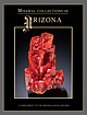
 | | Journal (issue) | | Vanadinite 3.4 cm, from the North Geronimo mine, La Paz County, Arizona. Dick Morris collection; Jeff Scovil photo...graders at the Copper Creek Elementary School in Oro Valley, spearheaded a campaign in 2014 to propose exactly...to my Representative, Mark Finchem (R-District 11, Oro Valley), asking him to be the primary sponsor...floor, right across from the famous “Alma Rose” rhodochrosite. The display was filmed by Bryan Swoboda’s BlueCap...cm, from the Defiance mine near Gleeson, Cochise County, Arizona. Ken Donn photo. 6 Supplement to The |  | | Report (volume) | | specimens. Some mineral aggregates, as clay, granite, limestone, sand, and sandstone, are included, because they...H. Purdue, Nashville, Tenn. California........Mr. William H. Storms, San Francisco. Prof. A. F. Rogers...Henry Landes, Seattle. West Virginia... .Dr. I. C. White, Morgantown. Wisconsin.........Prof. W. 0. Hotchkiss...See Bauxite and Hallpysite. Asbestos. Tallapoosa County, with corundum deposits near Dudleyville; not found...commercial quantity or quality. Asphalt. Colbert County, small quantity has been shipped from near Leighton; |  | | Report (volume) | | ............................................ California....................................................................................... 102 District of Columbia ....................................Some mineral aggregates, such as clay, granite, limestone, sand, and sandstone, are included because they...mineralogic reports, especially from those of Arkansas, California, Colorado, New Mexico, Oregon, South Dakota,...Bulletin, 1912. Eakle, A. S., Minerals of California: California State Min. Bur. Bull. 67, 1914. George |  | | Journal (article/letter/editorial) | | Two Point claim, Pikes Peak batholith, Teller County. The Collector’s Edge specimen, Jeff Scovil photo...Park 6. Devils Head 7. South Platte pegmatite district 8. Mount Antero 9. Ruby Mountain 10. Calumet iron...locality 15. Otero County barite occurrences 16. Royal Gorge (Eight Mile Park) pegmatite district 318 ROCKS...ROCKS & MINERALS 17. Micanite-Guffey pegmatite district 18. Devils Hole pegmatite 19. Grape Creek cordierite-gahnite...Mountain kimberlite 23. Crystal Mountain pegmatite district 24. Genessee Park calc-silicate locality 25. North |  | Finch, John Wellington, Bateman, Alan M., Butler, B. S., Loughlin, G. F., McLaughlin, D. H., Singewald, J. T. Jr. - Eds. (1933) Ore Deposits of the Western States. The American Institute of Mining and Metallurgical Engineers, New York. | Book | | United States Geological Survey, with headquarters at San Francisco. At this time Becker, who had recently...ode, was at work upon the mercury deposits of California and was preparing soon to undertake a systematic...apparently, to progress from one westei:n mining district to another, sioce thus new features a nd new relationships...The gold-qunrlz veins or .Nevada City and Grass Valley districts, Cal. 11th Ann. Rcpt. pt. 2, pp. HW2...in the geological resurvey of the Cripple Creek district, Colo. Geol. S urvey Bull. 254, 1904. 36 pp. (With |  | | Book (edition) | | criticising the manuscript. Thanks are due to Dr. David White of the Geological Survey, for criticising the data...anthracite region 10. Structure section in Tazewell County, east of Richlands, southwest 8. 9. 12. 13. ...house and tipple, bituminous coal mine, Spring Valley, 111 Northern Interior coal field Composite section...showing distribution of oil fields 103 Map of California oil fields and pipe lines North-south section...structure of western field of Los 104 Angeles district 106 Section of Spindle Top oil field near Beaumont |  | | Report (volume) | | commodities 78 ~anganese 78 Semiprecious gemstones 78 Limestone 79 Iron 79 Graphite in metamorphic rocks 79 Pegmatite...Boulder-Pioneer Wilderness Study Area, and the White Cloud-Boulder Roadless Area. The U.S. Geological...Mountains; and the southwestern tract covers the White Knob Mountains, Copper Basin, and the eastern part...sedimentary quartzite, argillaceous quartzite, local limestone and sandstone, and minor interbedded volcanic...deposited at this time ranged from dominantly limestone in the east, through clastic rocks, to dominantly |  | | Report (volume) | | Creek Formation and the Upper Mississippian White Knob Limestone. The Mackay mineralized area includes polymetallic...Mountain Section, Geological Society of America, Sun Valley, Idaho (Link and Hackett, 1988), and on December...Hill and Warm Springs mining districts, Blaine County, Idaho: Idaho Bureau of Mines and Geology Pamphlet...Deposits in the Lake Creek Mineralized Area, Blaine County, South-Central Idaho By Bradford R. Burton and...Mineral Deposits in the Washington Basin Area, Custer County, South-Central Idaho By J. Brian Mahoney H. Mineral |  | | Book (edition) | | Lithographic eral deposits limestone— Definition and origin stone^Hydraulic limestone ^Lime Uses— Dolomite...lead-zmc ores of the Mississippi valley Arkansas Upper Mississippi valley- Virginia and Tennessee— Southeastern...Southeastern Missouri Genesis of the Mississippi valley deposits— Northern Rhodesia. ('‘haractenstic — ...veins—Occurrence veins—Cripple Creek— Gold veins— The San Juan Republic, Washington — Sumatra— The — Telluride... region, district district-“' — — — Rico district—Lake City district— Creede district Summary C'asapaica |  | | Book (edition) | | in . 247 Limestone Definition and origin Chalk Lithographic stone Hydraulic limestone Lime Uses Dolomite...lead-zinc ores of the Mississippi Silesia localities Valley. CHAPTER XXIV Metalliferous Deposits Formed Near...Washington Sumatra — The base-metal veins — The San Juan Colorado — General features — Telluride —Silverton...telluride of region, district district district district district district Nevada. CHAPTER XXV...Al—Interior types —Paragenesis — Gold-quartz veins the California and Victoria the Sierra type— Principal characteristics |  | Palache, Charles, Berman, Harry, Frondel, Clifford (1951) The System of Mineralogy (7th ed.) Vol. 2 - Halides, Nitrates, Borates, Carbonates, Sulfates, Phosphates, Arsenates, Tungstates, Molybdates, Ect. John Wiley and Sons, New York. | Book (volume) | | to Professor Adolf Pabst of the University of California (Berkeley) for assistance in the preparation...Colorless; G. 2.168; 2.165 (calc), M.P. 804°.^ also white, yellow, red, blue, purple. The blue and purple...enclosed clay or iron oxide. Streak colorless to white; relatively coarsely powdered blue or purple halite...the Verde Valley, Yavapai County, Arizona. In Nevada along the Virgin River in Clark County, and in distorted...crystals from Humboldt County. From Borax Lake, San Bernardino County, California. In the Permian basin |  | | Book (edition) | | Chapters on the Coeur d'Alene Mining District, the Blackbird Mining District, and the Sawtooth Mountains by...Chapters on the Coeur d'Alene Mining District and the Blackbird Mining District, and to Ben Sheppard for reviewing...reviewing the chapter on the Blackbird Mining District. Those who contributed photographs, or specimens...problems are with mine names and occasional1y mining district names. Mining districts, generally are not now...the Coeur d'Alene District is the name presently used for the entire silver district that runs from Kellogg |  | | Book (edition) | | during sedi1nentation-Bioche1nical processes- Limestone-Definition and origin-Chalk-Lithographic stoneHyJraulic...lead-zinc ores of the l\ilississippi valley-Arkausas-Upper l\1ississippi valley-Virginia and Tennessee-Southeastern...Tennessee-Southeastern Missouri-Genesis of the l\1ississippi valley deposits-Northern Rhodesia. CIIAPTER X:1.-:IV DEPOSI'l'S...production and use-The Adriatic region-Almaden-California- Other districts-Genesis -Relation to other ore...veins- The San J uan region, Colorado-General features-Telluride district-Silverton district-Rico district-Lake |  | | Report (issue) | | listed on pages A253A258. Numerous Federal, State, county, and municipal agencies listed on pages A205-A210...--------------------39 Nevada -----------------------------40 California ---------------------------41 IIawaii and Guam...-------------------------------Shield area and Upper Mississippi Valley _______ _ Michigan --------------------------------Wisconsin...structural geology _______ _ Nevada and eastern California ________ _ Utah --------------------------------Arizona... Oregon ----------------------------------97 California -------------------------------Klamath Mountains |  | | Report (volume) | | anonymous papers, placed at the end of Part I Co. county cos. · counties CORPORATE AUTHORS. Am G American...Natural Histor: Cal Ac Sc California Academy of Sciences Cal M As California Miners' Association Cal St...St :M Bur California State Mining Bureau Can G S Canada, Geological Survey Can :M Br Canada, Mines Branch...09b Geologic history, application of biology to: White (C A), 86b Geologic history of myriapods and arachnids:...history of North American continent: Hall, 69, 83m; White (C A), 85c Geologic science, relation to education: |  | | Report (issue) | | A293-A298 of this chapter. Numerous Federal, State, county, 1and local agencies and other organizations and...the Coastal Plains__ Appalachian Plateaus and the Valley and Ridge provinces______________________ The Blue..._ _ Oregon _______________________________ _ California _____________________________ _ Nevada _____...cooperators ____________________________ _ 251 State, county, and local cooperators ______________ _ 251 Other...Regional offices ________________________ _ 259 District offices _________________________ _ 259 Offices |  | | Book (volume) | | termination of veins 87. 88. .... platinum district Mountains. Pyroxene-olivene-magnetite rock, showing...Ural 532 551 554 569 90. Ural 571 573 in limestone pegmatite into gneiss; Georgetown, Colorado....differentiation of molybdenite; Hxmt mine, Renfrew County, Ontario Sudbury, Ontario. Intrusive contact of...of 93. 94. 95. 96. Haggerty mine, Encampment district, Wyoming Bonanza, Zacatecas, Mexico. Surface geology...geology 98. Beatrice ore chimney. Bonanza district 99. Providencia tunnel. Bonanza mine 100. Bonanza |  | | Report (issue) | | Strategic: Minerals” in Udalio, ss Fee a ee eee 76 White Mavich with) Black Uno Groene ee ceeeee tee nee...Mine Rescue and First Aid, Coeur d’Alene Mining District .....0000...00000000...... 98 ise funn f orm atom...COUN yarns eee ESenTOCk COUI secre eee Bearsibake County 2222 -ccs.e--ceee Benewa byCounty see ee Bingham...enna Bonners COUNty gens ene eee 148 149 150 151 153 155 155 160 163 Bonneville County ........................... Boundary, County. ose Buttei@ ounty, eee eee eee Camas) Countyes eee ene Canyion= Count |  | | Report (volume) | | 220-228 Battery Street, New York, N. Y. San Francisco, California. THE MINES HANDBOOK BALL GRANULATORS...the iron mining companies of the Lake Superior district is given, and the many mining corporations of...Coal Equipment NEW YORK OFFICE 50 Church Street SAN FRANCISCO LONDON, CHICAGO OFFICE McCormick Building...UNITED STATES Alabama Alaska Arizona Arkansas California Colorado , Page 69 Connecticut 120 Georgia...Carolina Dakota.. MEXICO Aguascalientes Baja California Chihuahua Coahuila Durango Guanajuato Guerrero |  | | Report (issue) | | A. L. Bush -----------------------------------Limestone and dolomite, by Harold A. Hubbard and George...equivalent of the southeast 3 INTRODUCTION Missouri district can be expected to turn up in the future ; the...mid-1950's on the west side of the Southeast Missouri district resulted in the discovery of the large unexposed...part of the district. With the phoenixlike rejuvenation of the Southeast Missouri district, the Viburnum... Park, C. F., Jr., 1968, Affluence in jeopardy: San Francisco, Freeman, Cooper & Go., 368 p. Pratt, W |  | | Report (issue) | | Mear the Oentral Part of the Lemhl Range, Lemhi County, Itlaho tJ.S, GEOLOGICAL SURVEY PROFESSIONAL PAPER...Near the Central Part of the Lemhi Range, Lemhi County, Idaho By EDWARD T. RUPPEL and DAVID A. LOPEZ ...near the central part of the Lemhi Range, Lemhi County, Idaho. (U.S. Geological Survey professional paper...of mines ............................ Junction district ............................. Texas and Spring...Spring Mountain districts ............ Blue Wing district ........................... Other mines and prospects |  | | Report (volume) | | v BIBLIOGRAPHY AAPG, Pac1fic Sec 5290 See San Joaqum Geologtcal Soctety 4363 Abbey, Sydney, Maxwell...H1ldebrand, Fred A, Havens, R G Thalemte from Teller County, Colorado, zn Geolog1cal Survey Research 1962 U...Precambnan(?) and Cambnan stratigraphy m Esmeralda County, Nevada, m Geolog1cal Survey Research 1962 US Geol...P. Interpretation of the Dakota sandstone of the San Juan Basm, m SPWLA Loggmg Sympostum, 3d Ann Houston...data on the Chmax stock, Nevada Test S1te, Nye County, Nevada Geophystcs, v 27, no 5, p 599-610, tllus |  | | Book | | SCIENTIFIC MINING by the Press, and MAGAZINE, 1911. SAN FRANCISCO, LONDON. . 4 7 e + £ ad t iF...of certain of the illustrations. H. Foster Barn. San Francisco, December 1, 1911. Digitized by the Internet...sya « opeltare: en district . ...4 ss +s sedis «+10 «istese «la alee Ores: ... R. Buckley. . 103 The southeastern Missouri district ..........+0+:s+e++s sawn SEruChaPes 4.2 0's f'n...<0 +++ siciesice so 1 70cm ere enn The Joplin district: ;.. 4...-s-1« «saree, 4:cielae ye duelelere siete |  | | Report (volume) | | 220-228 Battery Street, New York, N. Y. San Francisco, California. THE MINES HANDBOOK, 1922 MACHINERY...of Mines. Located in the Lake Superior Mining district. Mines and Mills accessible for college work....ENGINE OIL Los Angeles, Kingman, Chloride and California Oatman, Arizona Sheffield Scientific School...487 Lovejoy 900 First Avenue. CLEVELAND ATLANTA SAN FRANCISCO LOS ANGELES PORTLAND. SEATTLE SONS JERSEY...Chicago, Minneapolis, FARREL New York, Boston, San Francisco AND ORE ROCK USED IN ALL PARTS OF THE |  | | Report (issue) | | Walden P. Pratt Katharine S. Schindler Willi s H. White Robert A. Zierenberg UNITED STATES GOVERNMENT PRINTING...geophysical exploration techniques, deposit and district studies, and laboratory research, the program...Paradise Peak gold-silver-mercury deposit, Nye County, Nevada-by David A. John, Robert E. Thomason, Charles...veins and breccias in the Mesquite district, southeastern California-by G.F. Willis, R.M. Tosdal, and S...lithofacies and their control on the Mississippi Valley-type mineralizing system in the Ozark region-by |
|


