 | | Journal (article/letter/editorial) | | GRAND, ISLE: L Jirrwowwux/ lot* llMt UK* U'A VERMONT Mineral Locality Index VANDALL T. K I N G P.O....Massachusetts 01776 MASSACHUSETTS Figure J. Vermont political divisions map; adapted from U.S. Geological...of New Hampshire and Vermont (1972). 324 ROCKS & MINERALS he state of Vermont is relatively small,...ry in the world is in Rochester (Windsor Co.), Vermont. Min eral products mined "as is" for their final...minerals found in Ver mont slate. Figure 2. Slate quarry, Poultney; photo by Roger Bacon. The granite industry |  | | Journal (issue) | | May 1983 No. 2 STRONTIUM MINERALS FROM WISE COUNTY, VIRGINIA - AN UPDATE 2 1 D. Allen Penick and...abundance in the area around East Stone Gap i n W i s e County, V i r ginia. Celestite is strontium sulfate (SrS04)...strontium o x i L . ~ l the l strontianite in W i s e County is probably calciostrontianite where calcium content...Province, extend frcm Wise County i n Southwest Virginia to Frederick County i n the northwestern corner...Wise County; 2. Hayters Gap washing.ton County; 3. saltville- Smyth County 4. Dublin Pulaski County Harrisanburg | 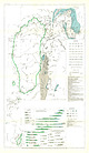 | | Journal (article/letter/editorial) | | thrust faults. About 8 miles south of Bennington, Vermont, the rocks of the Taconic Range approach the Green...interbedded with 836 gray slate 16. Structure map of limestone mass, south of Berlin, New York 838 INTRODUCTION...17. Graphitic limestone from quarry, North Pownal, Vermont 847 18. Calcitic limestone, 1 foot above thrust...thrust fault at west border of North Pownal limestone block 847 19. Bedding plane of gray slate, enclosing...in graywacke and slate 834 6. Deformation of limestone and slate near thrusts 835 7. Structure map of |  | | Report (volume) | | Jonesville District Lee County, Virginia GEOLOGICAL SURVEY BULLETIN 990 GEOLOGY AND OIL RESOURCES...RESOURCES OF THE JONESVILLE DISTRICT, LEE COUNTY, VIRGINIA By EALPI-I L. MILLER and WILLIAM P. BKOSGE ABSTRACT...ABSTRACT The Jonesville district is in central Lee County in the extreme southwest corner of Virginia. It...Ordoviciau dolomite. The upland is flanked by parallel lowlands developed on Ordoviciau limestone, and the...between the top of the Knox group and the Eggleston limestone. The Jonesville district was peneplaned in the |  | | Report (issue) | | _______--_-_.Wise County wells___________________________________________ Buchanan County wells.________...__________________-__L____--______-__-Dickenson County wells____________________________1__.____.Other counties...wells in West Virginia_ 71. Map of part of Buchanan County, Va., showing locations of test wells_--.__-__...__-___________________________ 72. Map of part of Dickenson County, Va., showing locations of test wells..._________...southwestern Virginia. About half of these are in Lee County; the remainder are in Scott, Washington, Smyth |  | | Report (issue) | | Mountain lies a broad, open valley, with fertile limestone soil, called Rich Valley. Much of this area is...'laminated earthy limestone. 1,150 Massive blue and gray fossiliferous limestone, in part grano-crystalline...red shales, earthy calcareous sandstone, impure limestone, and red clay with gypsum and salt beds. (Maccrady...Pocono age. 420 Price sandstone. Greenbrier limestone. forma- Massive reddish and gray arkosic sandstone...dark chert layers. Large Oriskany fauna. 125 Hancock 1 i m e stone. Silurian. Romney shale. Giles |  | | Report (issue) | | .In pocket Map of the Leidy gas field, Clinton County, Pa. ........ o ........... 95 Map showing general...gas pools, Butler and Summit Townships, Butler County, Pa. ........... 100 Composite columnar section...showing rocks encountered in the subsurface in Butler County, Pa. .................... 101 Map showing general...carbonate sequence which consists largely of limestone and dolomite. Some quartzose sandstone is present in...sequence, which consists predominantly of limestone and dolomite. It also contains a salt-bearing unit in |  | | Report (volume) | | vol. 12, pp. 223-240. Davenport, Iowa. Delaware County Institute of Science: Proceedings, vol. 5, nos...1-156; Bulletin, nos. 71-74. Washington, D..C. Vermont Geological Survey: [Seventh] report, 1909-1910...Washington, D. C. West Virginia Geological Survey: County Reports, Pleasants, Wood, and Ritchie Counties;...444, p. 13. Two areas of oil prospecting in Lyon County, western Nevada. U. S. Geol. Survey, Bull. 381...figs., 1910. Arey, Melvin F. 30. Geology of Butler County. Iowa Geol. Survey, vol. 20, pp. 1-59, 2 pis., |  | | Report (volume) | | the Ste. Genevieve Limestone is: Ste. Genevieve Limestone Ste. Genevieve Limestone (in Blue River Group)...Group) Ste. Genveieve Limestone (in Meramec Group) 1 The superscript (1) shows that the accepted name of...formation as of 1935 was the "Ste. Genevieve Limestone 1n the Meramec 4 LEXICON OF GEOLOGIC NAMES...the formation has been called "Ste. Genevieve Limestone in Blue River Group" in another area. Finally... LEXICON-PART 1, A-F Aarde Shalet Member (of Howard Limestone) Pennsylvanian (Virgil Series) : Eastern Kansas |  | | Report (volume) | | Clinton Formation, and Rockwood Formation. In Lee County, Va., and adjacent areas, two members of the Clinch...exposures were found at Little Moccasin Gap, Washington County, Va. As a type section has now been described in...Early Silurian age in the outcrop belts in Lee County, Va., but in Clinch Mountain, beds of early Middle...Sandstone, the Clinton Formation, and the Hancock Limestone (or Dolomite). In Tennessee, the Clinch Sandstone...overlying carbonate rocks (if present) are the Hancock Limestone. In southwestermost Virginia and northernmost |  | | Report (volume) | | eastern Canada Pleistocene fChamplain period l (Vermont-New York-Quebec) Iroquois stage * (Great Lakes...Senecan series [see under formation l] Seneca limestone >] Finger Lakes stage 2 Taghanie (Taughannock)...Mohawkian stage [see under Trenton [see Mohawkian limestone or series l (New group ! (New York); restricted...1 (New Brunswick) fGeorgian epoch or series l (Vermont) Labrador series 2 (Labrador) Hanfordian series...formation l fOzark sands 1 Tertiary t Alabama white limestone l Pliocene Citronelle formation l Miocene (f) |  | | Report (issue) | | formation of a shallow carbonate bank, the Shady Dolomite. Until recently, the Shady was con sidered to...sequence of shale, siltstone, and thin-bedded limestone (Conasauga Group) accumulated in the western part...is mainly dolomite in the central and western parts of the Valley and Ridge and limestone in the easternmost...Early Ordovician time, the distribution of dolomite and limestone was re lated to the development of a subtidal...Formation § Bangor Limestone • Hartselle Formation • ., ... Monteagle Limestone • Bluestone Formation |  | | Report (volume) | | ............................... Argillaceous limestone (cement rock)........:........'......... Cement.......................................... Slag-limestone mixtures .............................. General...Composition of the limestone ................. Advantages of using slag-limestone mixtures ... Wet methods..._.......-..-.............. 61 Chickainauga limestone. .....j............................ 61 Mississippian...chalk or "Eotten limestone" ....................... 72 St. Stephens or Vicksburg limestone.............. |  | | Report (volume) | | p. 58-59, 227. Mainly silty sandy thick-bedded dolomite containing layers of dolomitic medium-grained...74, Ph miles east of Dutchtown, Cape Girardeau County, Mo. Type section cut by northtrending fault with...stream in NEIA sec. 33, T. 16 N., R. 14 E, Wayne County. Named after village of Abington, about 3 miles...and siltstone, dolomitic sandstone, chert, and limestone. West of Adam Peak, where section is most complete...interbedded shale, limestone, and dolomitic sandstone; middle, about 950 feet thick, chert, dolomite, and dolomitic |  | | Report (volume) | | ............................. 69 Chickamauga limestone............................... 69 . Mississippian.......................... Selma chalk ("Rotten limestone").................... Lithology................................................ St. Stephens limestone................................. ' Lithology.......................................... Izard limestone...................:...................... Polk...Clair limestones........................ St. Joe limestone member of Boone formation............... Limestones |  | | Report (issue) | | finely to coarsely clastic rocks with some limestone and dolomite beds near its top. Its total thickness...above the Chilhowee Group consist mainly of limestone, dolomite, and shale, as do succeeding formations of... and are also noteworthy for their very dense dolomite members. One major red-bed unit, the Juniata Formation...and grades laterally southwestward into marine limestone and shale. Rocks of Silurian or Devonian age contain...the occurrence of a small intrusive body in Union County, Tenn. The rock is a mica-peridotite (Gordon, 1927; |  | | Report (issue) | | A late Tertiary low-angle fault in western Juab County, Utah, by D. R. Shawe _______________________________...part of the Timber Mountain dome and caldera, Nye County, Nev., by W. J. Carr_____________________ Diverse...Jr______________ Flood inundation mapping, San Diego County, Calif., by L. E. Young and H. A. Ray_________...hydraulic properties of glacial outwash in Portage County, Wis., by E. P. Weeks-------------------------...miles south of the town of l\farathon, Brewster County. The l\farathon Basin exposes a sequence of Paleozoic |  | | Report (issue) | | Thomson________________________________ Limestone and dolomite, by George E. Ericksen ·and Dennis P. ...Introduction___________________________ Uses of crushed limestone and dolomite_ Page 188 188 189 189 190 190 190... Page Construction materials-Continued Limestone and dolomite~Continued Occurrences in Appalachia_ ______________...Pa_____________________________ 18. Vertical quarry face in limestone, 160 feet high, 4 miles south of Franklin...____________ 20. Limestone pinnacles beneath soil cover, Bluegrass, Highland County, Va_ _ _ _ _ _ _ |  | | Report (volume) | | 5 in., inch or inches. Circ., Circular. Co., County or Company. Indus., Industrial. Inst., Institute...contemporaneous. Lib., Library. Contr., Contribution. ls., limestone. Coop., Cooperative. lss., limestones. cor., corner...Mining. div., division. mi., mile or miles. dol., dolomite. Mid., Midwest, Midland. E., east. Min., Mining...Pre-Cambrian : Central southern Virginia (Mecklenburg County). F. B. Laney, 1917 (Va. Geol. Surv. Bull. 14,...discarded, and is replaced with Arroyo fin. Abilene limestone. See 1925 entry under Abilene cgl. Abitibi group |  | | Report (volume) | | names. As an illustration, the name Berkshire limestone was first applied to certain limestones in western...Massachusetts. Subsequently the name Stockbridge limestone was employed to designate this formation and has...the Cambrian in that region. The name Berkshire limestone has therefore become obsolete, and the name might...(F.), Report on the Geological Survey of Miami County, Kans., 1865. ' Kansas University Geological Survey:...Report on Geology of'Mercer County. Report on Geology of Lincoln County. Report or Geology of Henry, |  | | Report (volume) | | Proceedings, vol. 13, pp. 1-46. Davenport, Iowa. Delaware County Institute of Science: Proceedings, vol. 7, no....47; vol. 48, pp. 1-58,115-193. Washington, D. C. Vermont Geological Survey: Report of the State Geologist...Virginia Geological Survey: County Reports, Kanawha County; Preston County; Map of... coal, oil, etc....16. Ancient auriferous gravel channels of Sierra County, California: Am. Inst. Min. Eng., Bull., no. 91...deposits of the San Juan district, San Luis Obispo County, California: California Acad. Sci., Proc., 4th |  | | Report (issue) | | ___________________ 121. Thalenite from Teller County, Colorado, by J. W. Adams, F. A. Hildebrand, and...Precambrian(?) and Cambrian stratigraphy in Esmeralda County, Nevada, by J. P. Albers and J. H. Stewart_____...Formation, and Dunderberg Shale east of Yucca Flat, Nye County, Nevada, by Harley Barnes, R. L: Christiansen,...-------------------129. Age of the Leadville Limestone in the Glenwood Canyon, western Colorado, by W...Pennsylvanian age, and adjacent beds, Washington County, Arkansas, by L. G. Henbest __________________ |  | | Book (edition) | | the total of 4,284 new Terms were United States county and city Terms. Counties and Cities in the United...States Earlier editions had Terms such as Washington County and Portland for counties and cities of the United...for example: Washington County Arkansas and Portland Maine. Each new county Term can now autopost its...to counties was a major task. The scope of U.S. county and city Terms can now be clear even when they...For example, whenever an in¬ dexer uses Atchison County Kansas the Terms Kan¬ sas, Midwest, and United |  | | Report (issue) | | Alberta, and parts of Alaska. Content: Jurassic limestone and shale of Nevada; Mariposa slate, Sierra Nevada;..."Carboniferous, undivided." Content: Permian limestone and red beds, Kansas to Texas; Permian red beds...equivalents where distinguished; Carboniferous limestone of Guatemala. Mapped elsewhere with "Carboniferous...where present; Mankomen formation and N abesna limestone of Alaska; Lisburne formation, Alaska; Carboniferous...Arctic, the Silurian color covers areas of the limestone series, known to include Ordovician and Silurian |  | | Report (volume) | | Wills Creek Shale, and Tonoloway Limestone of Silurian age; Keyser Limestone of Silurian and Devonian ( ?)...age; the Helderberg Group (Coeymans Limestone, New Scotland Limestone, and Mandata Formation), Oriskany...quantity of limestone. The largest amount of high-calcium rock is in the Keyser Limestone. Some beds of...of limestone in the Keyser are as much as 90 percent calcium carbonate. Silica in the form of chert nodules...contaminant. Some of the best quality Tonoloway Limestone may contain as much as 80 percent caldum earbonate |
|


