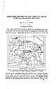
 | | Report (issue) | | DEPOSITS OF THE CADDO GAP AND DE QUEEN QUADRANGLES, ARKANSAS. By HUGH D. MISER. INTRODUCTION. The high prices...little-exploited manganese deposits of westcentral Arkansas. These deposits are found at intervals in a belt...quadrangles, Arkansas and Oklahoma. 12 miles wide, extending west-southwestward from Pulaski County, at the...the center of the State, to Polk County, on the west border. Eecent exploitation, begun in 1915 and still...Caddo Gap and De Queen quadrangles, in western Arkansas. The location of the mountainous districts of |  | | Report (edition) | | STATE OF ARKANSAS BULLETIN 23 S P EC I ES O F A RKA N SA A DIGEST By J. Michael Howard \ 1987... / ARKANSAS GEOLOGICAL COMMISSION Norman F. Williams State Geologist s·' , STATE OF ARKANSAS BULLETIN...23 SPECIES OF ARKANSAS A DIGEST By J. Michael Howard 1987 Little Rock ARKANSAS GEOLOGICAL COMMISSION...State Geologist STATE OF ARKANSAS Bill Clinton, Governor ARKANSAS GEOLOGICAL COMMISSION Norman...Magnet Cove areas of Arkansas. The trip was conducted by Mike Howard of the Arkansas Geological Commission |  | | Report (edition) | | STATE OF ARKANSAS BULLETIN 23 MINERAL SPECIES OF ARKANSAS A DIGEST By J. Michael Howard 1987 Revised...Little Rock ARKANSAS GEOLOGICAL COMMISSION Norman F. Williams State Geologist STATE OF ARKANSAS BULLETIN...SPECIES OF ARKANSAS A DIGEST By J. Michael Howard 1987 Revised 2007 Little Rock ARKANSAS GEOLOGICAL...Williams State Geologist STATE OF ARKANSAS Bill Clinton, Governor ARKANSAS GEOLOGICAL COMMISSION Norman F...Magnet Cove areas of Arkansas. The trip was conducted by Mike Howard of the Arkansas Geological Commission |  | | Report (volume) | | Alabama.........Dr. Eugene A. Smith, University. Arkansas..........Dr. A. H. Purdue, Nashville, Tenn. California...See Bauxite and Hallpysite. Asbestos. Tallapoosa County, with corundum deposits near Dudleyville; not found...commercial quantity or quality. Asphalt. Colbert County, small quantity has been shipped from near Leighton;...following localities: Bibb County, Pratts Ferry; Calhoun County, near Tampa; Clay County, T. 20, Pv. 7 E.; Jefferson...Jefferson County, at Elyton; Lee County, at Chewacla lime works; St. Clair County, at Gfeensport; Shelby |  | | Report (volume) | | ............................................. Arkansas.................................................mineralogic reports, especially from those of Arkansas, California, Colorado, New Mexico, Oregon, South...examination of the geology of western central Arkansas: Arkansas Geol. Survey Ann. Kept, for 1888, vol. 1...J. C., The zinc and lead region of north Arkansas: Arkansas Geol. Survey Ann. Kept, for 1892, vol. 5...relative to the economic-geologic products of Arkansas, prepared for the Southern Commercial Congress |  | | Journal (article/letter/editorial) | | left). Calcite, 5.5 cm high, Elmwood mine, Smith County. Terry Huizing specimen, Jeff Scovil photo. Figure...(above). Fluorite, 13.1 cm wide, Elmwood mine, Smith County. Francis Benjamin specimen, Jeff Scovil photo....Smith County. Terry Huizing specimen and photo. Figure 4 (right). Cumberland mine, Smith County. Travis...earths to make saltpeter, at Nicojack Cave in Marion County, then nitromagnesite at the same location (Shepard...Sevier County (Coskren and Lauf 2000). The following index is arranged alphabetically by county. It is |  | | Journal (article/letter/editorial) | | 2014 Wavellite Mauldin Mountain, Montgomery County, Arkansas P hosphate minerals are a traditional favorite...specimen was a wavellite from one of the traditional Arkansas localities, for these have been available from...wavellite from Mauldin Mountain, Montgomery County, Arkansas; kevin Brown specimen, Joe Budd photo courtesy...Limestone Company quarry, Pleasant Mills, Snyder County, Pennsylvania. The 2.8 × 2.7 × 1.5-cm specimen...Day Township, Saratoga County, New York; another at Jamestown, Newport County, Rhode Island; and one |  | | Report (volume) | | Gulf region Continued. 5 Pa^e. West-central Arkansas...:....................................................................*..................... Arkansas............................... '. ..............showing concentric layers of pyrolusite and psilomelane.... 8. Map showing the principal manganese mines...principal manganese mines in the Batesville district, Arkansas, and the probable extent of the ore-bearing area...the occurrence of manganese ores in west-central Arkansas.............................................. |  | | Report (volume) | | Resources of the Caney Creek Wilderness, Polk County, Arkansas By GEORGE E. ERICKSEN and SAM H. PATTERSON...resources of the Caney Creek Wilderness, Polk County, Arkansas. (Geological Survey bulletin; 1551) Bibliography:...no.: I 19.3:1551 1. Mines and mineral resources-Arkansas-Caney Creek Wilderness. 2. Caney Creek Wilderness...mineral survey of the Caney Creek Wilderness, Arkansas, in the Ouachita National Forest. Caney Creek...RESOURCES OF THE CANEY CREEK WILDERNESS, POLK COUNTY, ARKANSAS By GEORGE E. ERICKSEN and SAM H. PATTERSON |  | | Report (issue) | | HOUSE OF THE GEORGIA COMPANY NEAR \YHlTE , BARTOW COUNTY. GEOLOGICAL SURVEY OF GEORGIA S. W. McCALLIE...Pyrolusite ....................................... . Psilomelane ..................................... . Wad ...indiYidnal County ...................................... . Rhea property.... . . . . . . . . . . . . . . . 136-138 Bartow County Pauper Farm ........................ 138-140 Vaughan............... 148-149 Other prospects in Bartow County ................... 149-154 C. C. Brown property |  | | Journal (article/letter/editorial) | | crystals, Arkansas also boasts an array of other minerals, as evidenced by this county-by-county description...continued with mining in north ern and western Arkansas and Magnet Cove during the Civil War, and peaked...in full swing and the demand for and price of Arkansas quartz crystals has skyrocketed. In October 1987...exploited. Continued interest in and study of Arkansas minerals, par ticularly the microminerals, will...for their good companionship during my years of Arkansas collecting. Particular thanks goes to these hardcore |  | | Book (edition) | | mmed at Broken Arrow aud Trout creek, in Sc. Clair county. The strata in this field are more faulted und...prong of Canoe creek, in St. Clair county, to Ha\sop creek, in Bibb county, a distance of 60 miles. Down to...to Helena, in Shelby county, the field has an average width of 5 or 6 miles. Below that point the width...miles being in the latitud" of Blocton, in Bibb county. The south ern end of this field has a greater...Jefferson county; Helena, Montevallo, and Brierfield, Shelby county; and at Blocion. Bibb county. The Warrior |  | | Report (volume) | | ............................... Coble, Hickman County, Tenn.......................... Silver Bluff, S...Oak Mountain manganese area, 276 52. Bradley County, Tenn........................ Geologic map of the...manganese prospects in the Rock Run area, Cherokee County, Ala.............. Maps of the Cedartovm, Ga,,...Taylor Ridge, 5 miles north of Gore, Chattooga County, Ga. The cobalt seems to be associated with the...occurs in tripoli in the Fort Payne chert in Perry County, Term., and here too the cobalt is in manganese |  | | Journal (article/letter/editorial) | | Bross Ave., Longmont, Colo. Globe, in southern Gila County, is in S/'E Arizona. FLORIDA—"I am sending some...chalcedony—almost an agate ! Lakeland, in N / W Polk County, is in central Florida. GEORGIA — "The enclosed...Ro.r.e, Ga. Summerville is in centra! Chattooga County in N / W Georgia. MAINE — A few months ago David...flesh-colored feldspar. Blue Hill, in S/W Hancock County, is in southern Maine. MINNESOTA—"This is not a...This is a Mesabi Range version of the mineral psilomelane. I hit the jackpot on this stuff the last time |  | | Book (volume) | | beds, excavations, etc.Selenite roses. BRULE COUNTY AREA: in the Oacoma zone of the Pierre Fm. On Elm...gray Barite rosette up to 5 or 6 inches. CAMPBELL COUNTY MOUND CITY, W to the Missouri R., regional hillsides...gravels, etc.petrified wood, wood opal. CORSON COUNTY LITTLE EAGLE: area ridges, slopes, stream beds...Guide for Rock Hounds in the United States CUSTER COUNTY AREA: The November Mine, 1.2 mi. SE of the Needles...of rd. a few yds., outcropRose Quartz. DOUGLAS COUNTY CORSICA, S on US 281 to Armour, area rd. cuts, |  | | Journal (issue) | | Walter Mayfield manganese prospect, Jeff Davis County, Texas. men ofa black botryoidal manganese oxide...located about 22 miles south ofVan Hom in Je ff Davis County, Texas (Baker I 934). However, the mineral is ca...Romanechite is the name for most of what was called psilomelane, a catch all name for all unidentified but manganese...manganese oxide minerals. However, unlike psilomelane, romanechite has a specific composition. The piece...Walter Mayfield manganese prospect, Jeff Davis County, Texas. Fig. 3 Romanechite crystals, micro, from |  | | Report (volume) | | meridian of 76° 30', from Tompkins County, New York, to Bradford County, Pennsylvania, by Henry S. "Williams...cents. 16. On the Higher Devonian Faunas of Ontario County, New York, by John M. Clarke. 1885. 8°. 86 pp....57 pi. Price 25 cents. 38. Peridotite of Elliott County, Kentucky, by J. S. Diller. 1887. 8°. 31 pp. 1.............................................. Psilomelane....... ........................................Oatawba, Oaldwell, Burke, McDowell, Rutherford, Polk, Cleveland, Cherokee, Jackson, Transylvania, and |  | | Book (volume) | | ASHTABULA COUNTY CONNEAUT, area pits, quarries, rd. cuts, etc.⎯cone-in-cone Calcite. CLERMONT COUNTY MILFORD...CLINTON COUNTY WILMINGTON, area of Todd’s Ford, a mineral deposit⎯Hematite. COSHOCTON COUNTY AREA, townships...CUYAHOGA COUNTY CHAGRIN FALLS (on Geauga Co. line), area quarries⎯oilstone. DELAWARE COUNTY DELAWARE...nodules⎯Pyrite (crystals sharply cubic). FRANKLIN COUNTY COLUMBUS, area countywide exposures of blue clay...HIGHLAND COUNTY SINKING SPRING, area ore deposit (most important in Ohio) ⎯Hematite. HOCKING COUNTY AREA |  | | Book (volume) | | ASHTABULA COUNTY CONNEAUT, area pits, quarries, rd. cuts, etc.⎯cone-in-cone Calcite. CLERMONT COUNTY MILFORD...CLINTON COUNTY WILMINGTON, area of Todd’s Ford, a mineral deposit⎯Hematite. COSHOCTON COUNTY AREA, townships...CUYAHOGA COUNTY CHAGRIN FALLS (on Geauga Co. line), area quarries⎯oilstone. DELAWARE COUNTY DELAWARE...nodules⎯Pyrite (crystals sharply cubic). FRANKLIN COUNTY COLUMBUS, area countywide exposures of blue clay...HIGHLAND COUNTY SINKING SPRING, area ore deposit (most important in Ohio) ⎯Hematite. HOCKING COUNTY AREA |  | | Book (edition) | | Gummite. 102. Glauconite. 21. Troilite. 60. Psilomelane. 103. Serpentine. 101. Stilpnomelane. 22....ities and suggestions from Mrs. H, A. Burdick county, of Mr. J. of A. D. Stephenson of Statesville...Catawba, Caldwell, Burke, McDowell, Rutherford, Polk, Cleaveland, Cherokee, Jackson, Transyvania aud... have been found at the Reid Mine, in Cabarrus county, the Crump Mine and the Swift Island Mine, in Montgomery...the Little John Mine, in Caldwell county, and Pax Hill in Burke county. Very beautiful arborescent gold |  | | Book (volume) | | ...........................................19 Arkansas ................................................rights, so remember you were told. If in doubt, a county map will tell you who the legal owner is. Good...gemmy qualities for cutting and polishing. AUTAUGA COUNTY PRATTVILLE, N. 6 mi., and just E of the Birmingham...were well known to prehistoric Indians.) BARBOUR COUNTY BAKER HILL, SE 1 mi. : 1 in a deep ravine, as a...deep red to variegated⎯ocher. BIBB COUNTY GENERAL AREA: c county gravel pits along the Cahaba R.⎯gemmy |  | | Book (volume) | | ...........................................19 Arkansas ................................................rights, so remember you were told. If in doubt, a county map will tell you who the legal owner is. Good...gemmy qualities for cutting and polishing. AUTAUGA COUNTY PRATTVILLE, N. 6 mi., and just E of the Birmingham...were well known to prehistoric Indians.) BARBOUR COUNTY BAKER HILL, SE 1 mi. : 1 in a deep ravine, as a...deep red to variegated⎯ocher. BIBB COUNTY GENERAL AREA: c county gravel pits along the Cahaba R.⎯gemmy |  | | Book | | M>f*es MANUFACTURES AND AGRICULTURE v MAP OF ARKANSAS Rur Reproduced on a reduced scale from map by...1 /. I y & ..vu. t u.vy UNIVERSITY OF I Arkansas," Washington, D. C., 1 907. , / \/ QUATERNARY...Mississippian ECONOMICS & SOCIOLO, Rocks MINERA IN ARKANSAS INCLUDING A REVIEW OF OIL AND GAS CONDITIONS...MINES, MANUFACTURES AND AGRICULTURE STATE OF ARKANSAS LITTLE ROCK, ARK. 1922 TABLE OF CONTENTS Page...Features Principal Arkansas Minerals and Their Location by Counties Counties of Arkansas and Their Mineral |  | | Report (issue) | | ......................................... Dade County ....................................................................................... Catoosa County ........................................................................................ Walker County ..................................................................................... Chattooga County ............................................................. 100 Sand Mountain coal area, Dade County .............................................. |  | | Report (issue) | | Western & Atlantic Railroad near Cartersville, Bartow County, Georgia. View Showing the Ridge-Valley Type of...Topography, in the Cartersville District, Bartow County, Georgia. An Exposure of Weisner Quartzite along...Railroad, One Mile East of Cartersville, Bartow County, Georgia. Manganese Milling Plant of the Blue Ridge...Cartersville, Bartow County, Georgia. View of Weisner Quartzite near Cartersville, Bartow County, Georgia. Log...Place, Five Miles Northeast of Cartersville, Bartow County, Georgia. Mang8.nese Ore ·washer on Milner-Harris |
|


