 | | Journal (article/letter/editorial) |
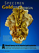
| from GEORGIA Figure 1. A rare crystallized gold specimen from the Loud mine in White County, Georgia...is part of the former geology collection of the Georgia Capitol Museum and is now exhibited at Tellus Science...lthough famous for its historical gold production, Georgia has few gold specimens with acceptable attribution...Science Museum 100 Tellus Drive Cartersville, Georgia 30120 juliang@tellusmuseum.org ROBERT B. COOK...placer and saprolite deposits and as visible gold in quartz mined from lode deposits. Crystals are rare, but |
 | | Report (issue) |
| <:I·:OR<: I A. 1'1.. ·1 TF I GEOLOGICAL SURVEY OF GEORGIA W. S. YEATES, State Geologist BULLETIN No. 4-...PRELIMINARY REPORT ON A PART OF THE Gold Deposits of Georgia BY W.S.YEATES State Geologist AND S. W. MCCALLIE...Geological Survey of Georgia (Ex-Officio) His ExcELLENCY, W. Y. ATKINSON, Governor of Georgia, PRESIDENT THE...the Advisory Board of the Geological Survey of Georgia, SrR: - I have the honor, to submit, herewith,... State Geologist. • THE GOLD DEPOSITS OF GEORGIA CHAPTER 1 THE OCCURRENCE AND HISTORY OF GOLD |
 | | Report (issue) |
| NORTHEASTERN PORTION OF THE DAHLONEGA GOLD BELT Jerry M. German Georgia Department of Natural Resources...Division Georgia Geologic Survey •,, THE GEOLOGY OF THE NORTHEASTERN PORTION OF THE DAHLONEGA GOLD BELT...BELT Jerry M. German .( Georgia Department of Natural Resources J. Leonard Ledbetter, Commissioner...Figures Figure Page 1. Geographic extent of the Dahlonega gold belt showing study area ...................northeast of the Dahlonega area ....................... . 14 15. Part of the Dahlonega gold belt showing |
 | | Book |
| org/details/georgiagoldrusht0000will The Georgia Gold Rush THE GEORGIA GOLD RUSH Twenty-Niners, Cherokees...Dancing Houses, & Drinking Saloons”: Life in the Georgia Gold Region Chapter Seven “Prosper the Americans...evidence of a gold strike in Georgia Gold miners in nineteenth-century Lumpkin County John Ross, principal chief...Gilmer, governor of Georgia (1829-31, 1837-39) Wilson Lumpkin, governor of Georgia (1831-35) Drawing tickets...boat Bracing a mine tunnel Entrance to a gold mine in Lumpkin County Gold-bearing quartz vein at the Hamilton |
 | | Report (issue) |
| TY, GEORGI A PLATE t GEOLOGICAL SURVEY OF GEORGIA S. W. McCALLIE, State Geologist BULLETIN No.... 19 SECOND REPORT ON THE GOLD DEPOSITS OF GEORGIA BY S. P. JONES Assistant State Geologist ATLANTA...Survey of Georgia in the Year 1909 (Ex-Officio) His ExcELLENCY, HOKE SMITH, Governor of Georgia PRESIDENT...Schools LETTER OF TRANSMITTAL GEoLOGICAL SuRVEY OF GEoRGIA, ATLANTA, June 15, 1909. To His Excellency, HoKE...the Advisory Board of the Geological Survey of Georgia. SIR: I have the honor to transmit herewith for |
 | | Report (issue) |
| orth Carolina and South Carolina ______ ____ _ Georgia ___________________________________ _ Alabama ...__ _________________________ _; _____ _ Barren quartz veins ________________ _ Mineralized zones ___________...34 35 35 36 39 44 44 45 46 47 47 49 49 50 50 Mine descriptions ___________ --------- -- .. -------...___ _______________________ _______ _ Fauquier County ____ ______ ______ _____ _____ _ Franklin ____...properties _________ .. _____________ _ Halifax County ______ - _____ - __________ ~- _'- __ _ Virgilina |
 | | Journal (article/letter/editorial) |
| thus extracted, passes down through underground Yahoola River. to the basement, and conduits is washed...with �-inch ditch conveys the water from the Yahoola River to a lead, cylindrical, 5 by 8 feet inside...concentrates by the cyanide of potassium process. The Dahlonega Gold Mining Company and the Chicago and each...concentrating tab les. copper, mining, and North Georgia 40-horse power wheels operate But in several...brings vated water from a point in the dates Yahoola River about seven on which it sinuous, and |
 | | Report (issue) |
| COVER PHOTO : Gold nugget from Dukes Creek, White County, weight 5 oz., 12 dwt., approx. 2x. BACK COVER...approx. 1.5x. Lower left - Goethite from Pulaski County, approx. lx. Right - Magnetite crystal face showing... MINERALS OF GEORGIA: THEIR PROPERTIES AND OCCURRENCES by Robert B. Cook STATE OF GEORGIA DEPARTMENT OF............................................. 153 Quartz ........................................................................................... 170 County Index ........................................ |
 | | Report (issue) |
| Society of America, Atlanta, Georgia April 6, 1989 Edited by Robert B. Cook Georgia Department of Natural...Natural Resources Environmental Protection Division Georgia Geologic Survey BULLETIN 117 I The papers presented...herewith have not undergone review procedures of the Georgia Geologic Survey's Quality Assurance Plan. They...necessarily reflect the technical opinions of the Georgia Geologic Survey. Proceedings of the Symposium...of the Geological Society of America, Atlanta, Georgia April 6, 1989 Edited by Robert B. Cook Department |
 | | Report (issue) |
| GEORGIA STATE DIVISION OF CONSERVATION DEPARTMENT OF MINES. MINING AND GEOLOGY GARLAND PEYTON, Director...BULLETIN NUMBER 48 MICA-BEARING PEGMATITES OF GEORGIA By A. S. FURCRON Assistant State Geologist and...< "'< Sheet Mica from the Early-Vaughn mine, Lamar County. J '\ LETTER OF TRANSMITTAL DEPARTMENT...herewith Georgia Geological Survey Bulletin No. 48, "The Mica-Bearing Pegmatites of Georgia," by Dr....connection with the prosecution of the present war. Georgia is one of four or five states in the nation which |
 | | Report (issue) |
| ‘ Li, aie! BARTLETT'S/27 FERRY FAULT } i GEORGIA ALABAMA sy .i % OP A iar an waeew ows mp ede...ug 5; “A BARTLETT'S/.2 FERRY FAULT ? ALABAMA GEORGIA 50 . Lee 50 MILES SO KILOMETRES UNIVERSITY...Hollister in this volume on the sulfide deposits of Georgia-Alabama. from does It has been the authors not...Alleghany County, North Carolina (John E. Callahan, J. Hatten Metal Howard Mines Georgia Models and...at Four Gold Slate Belt Mine, 97 F. Hollister) Lancaster Mines in County, is 124 (Henry Bell) |
 | | Report (issue) |
| STATE GEORGIA DIVISION OF CONSERVATION DEPARTMENT OF MINES, MINING AND GEOLOGY A. S. Furcron, Director...Bulletin Number 79 ANNOTATED BIBLIOGRAPHY OF GEORGIA GEOLOGY THROUGH 1959 by Howard Ross Cramer, Arthur...James George Lester Emory University, Atlanta, Georgia ATLANTA 1967 LETTER OF TRANSMITTAL Department...Governor of Georgia and Commissioner Ex-Officio State Division of Conservation Atlanta, Georgia 30334 Dear...and Geology entitled, "Annotated Bibliography of Georgia Geology Through 1959," by Drs. Howard R. Cramer |
 | | Book (volume) |
| Location Guide for Rock Hounds in the United States GEORGIA Georgia’s nearly 59,000 square miles makes it the...highest elevation in the state at 4,784 feet. 145 Georgia Beginning in the northwest, where the Lookout...mountains loom over rich agricultural valleys, Georgia easily divides into five major physiographic provinces...The first real Gold Rush in America occurred in Georgia following two simultaneous discoveries of Gold...White Co. and the other on the Bear Cr. near Dahlonega in Lumpkin Co. Not only was placer and lode gold found |
 | | Report (volume) |
| APPALACHIANS ;/ L. C. GRATON WITH NOTES ON THE DAHLONEGA MINES BY WALDEMAR LINDGREN .....623°1:~·:··...____ ____ __________________ _____ ______________ .Quartz"sericite schist ____ : ____________ . __________...__________ ,__ Quartz schist __ __ __________ __ . _ __ ____ __ __ ____ __ __ __ __ __ __ _ Quartz-sericite...________. ___ __ __ __ __ __ __ __ __ __ __ __ __ ___ Quartz-biotite schist __________ __. _ __ __ __ __ __...___ . _....... _. _. _____ .... ______ 83 Colossus mine ___ ..... _o ••• _ • • • • • • • • • • • •• ••• |
 | | Report (issue) |
| 5.1 cm high from Eagle's Nest mine in Placer County, Caifornia, USA Collection Marlin Zinn; photo Jeff...International, LLC P.O. Box 263, East Hampton, CT 06424, USA Phone 1.860.267.1512; fax 1.860.267.7225 www.lapisint...Lapis International, LLC East Hampton, Connecticut USA Collection 'Alan Table of Contents What Is Gold...First Gold Rush: Gold Fever in the Southeastern USA . . . . . . . .P. 16 R. Chris Tacker California and...Right: Irish Creek, Grass Valley, Placer County, California, USA 3.4 cm high; Canadian Museum of Nature; |
 | | Book (volume) |
| ..........................................122 Georgia ...............................................................................458 Appendix B - Quartz Family Gemstones ................................rights, so remember you were told. If in doubt, a county map will tell you who the legal owner is. Good...includes granites, schists (mica, garnet, graphite, quartz), and gneisses, as well as numerous granite pegmatites...gemmy qualities for cutting and polishing. AUTAUGA COUNTY PRATTVILLE, N. 6 mi., and just E of the Birmingham |
 | | Book (volume) |
| ..........................................122 Georgia ...............................................................................460 Appendix B - Quartz Family Gemstones ................................rights, so remember you were told. If in doubt, a county map will tell you who the legal owner is. Good...includes granites, schists (mica, garnet, graphite, quartz), and gneisses, as well as numerous granite pegmatites...gemmy qualities for cutting and polishing. AUTAUGA COUNTY PRATTVILLE, N. 6 mi., and just E of the Birmingham |
 | | Book (edition) |
| •••••••••••••••••••••••••••••••••••••• CT 1-2 Georgia GA 1 14 Idaho ................................'...Guide and Prospecting Permit may NOT prospect or mine on GPAA listed claims or other property reserved...Gold Occurrences AL-2 AIABAMA History I ,ike Georgia and North Carolina, Alabama had a "rush" of its...discovery of gold in 1830 in oldAutauga (now Chilton) County along tributaries of Chestnut and Blue Creeks,... Alabama placer gold may be found in: Chilton County: nuggets weighing up to 3.38 ounces have been recovered |
 | | Report (volume) |
| Deposits of minerals of wide distribution, such as quartz and calcite, have been omitted, except those that...Florida............Dr. E. H. Sellards, Tallahassee. Georgia..........Dr. S. W. McCallie, Atlanta. Illinois...See Bauxite and Hallpysite. Asbestos. Tallapoosa County, with corundum deposits near Dudleyville; not found...commercial quantity or quality. Asphalt. Colbert County, small quantity has been shipped from near Leighton;...following localities: Bibb County, Pratts Ferry; Calhoun County, near Tampa; Clay County, T. 20, Pv. 7 E.; Jefferson |
 | | Report (volume) |
| ............................................. Georgia..................................................of minerals that are widely distributed, such as quartz and calcite, have been omitted, except those that...Florida-______Dr. E. H. Sellards, Tallahassee. Georgia,_____Dr. S. W. McCallie, Atlanta. Idaho______.Mr...See Bauxite and Halloysite. Asbestos. Tallapoosa County, with corundum deposits near Dudleyville; not found...commercial quantity or quality. Asphalt. Colbert County, small quantity has been shipped from near Leighton; |
 | | Report (volume) |
| General features____________________________ Coosa County _________ ____________________ Randolph County...__ JsTew Haven County__________________________ Georgia ____________________________________ General features...Continued. Georgia Continued. Page. Cherokee County_____________________________ 72 Elbert County ______...County_______________________________ 76 Hart County. ___ __ __________________ 77, Lumpkin and Union counties_____________________...___________ S3 Pickens County _______-______________________ 83 Rabun County-_____________________________ |
 | | Report (issue) |
| GEOLOGICAL SURVEY OF GEORGIA S. W. McCALLIE. State Geologist / BULLETIN No. 37 PRELIMINARY REPORT ON...ON THE SAND AND GRAVEL DEPOSITS OF GEORGIA BY L. P. TEAS Assistant State Geologist 1921 BYRD PRINTING...DEPOSI1'S OF GEORGIA PLANT AND PIT OF THE GEORGIA SAND & GRAVEL COMPANY, AUGUST A, RICHMOND COUNTY FRO.NTISPIECE... THE ADVISORY BOARD OF THE _Geological Survey of Georgia IN THE YEAR 1921 (Ex-Officio) His Excellency, HUGH...HUGH M. DORSEY __________ Governor of Georgia -President ofthe Board- ____ _ HON. S. G. McLENDON _____ |
 | | Book |
| commercial ores and secondary minerals by state, county, township, and geologic range. For easy identification...61 232 PART The Making 43 II 5 7 3 III Mine PART 267 IV Glossary 279 Bibliography 291...cities, and many of today’s prosperous western county seats began as mining-boom camps. trating sand...Whether you such as those listed alphabetically by county, township, and range in Part II of this book. Where...minerals which make lovely cabinet specimens. old mine western states, to kick up and oxidation, |
 | | Report (issue) |
| 265 Tripoli and rottenstone__ __ _____ ___ __ 266 Quartz abrasives____________________ 266 Artificial a...sulfides____________________________ Sulfide-bearing quartz veins__________ Native copper deposits __________...pinnacles beneath soil cover, Bluegrass, Highland County, Va_ _ _ _ _ _ _ _ _ _ _ _ _ _ _ _ _ _ _ _ _ _...transverse joints cutting shale at Poverty, Highland County, V a_ _ _ __ _ _ _ _ _ _ _ _ _ _ _ _ _ _ _ _ _...__ 24. Strip-mine areas and coal-bed fires in the Appalachian Region__ 25. Strip coal mine, Coalton, W |


