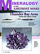
Log InRegister
Quick Links : The Mindat ManualThe Rock H. Currier Digital LibraryMindat Newsletter [Free Download]
Home PageAbout MindatThe Mindat ManualHistory of MindatCopyright StatusWho We AreContact UsAdvertise on Mindat
Donate to MindatCorporate SponsorshipSponsor a PageSponsored PagesMindat AdvertisersAdvertise on Mindat
Learning CenterWhat is a mineral?The most common minerals on earthInformation for EducatorsMindat ArticlesThe ElementsThe Rock H. Currier Digital LibraryGeologic Time
Minerals by PropertiesMinerals by ChemistryAdvanced Locality SearchRandom MineralRandom LocalitySearch by minIDLocalities Near MeSearch ArticlesSearch GlossaryMore Search Options
Search For:
Mineral Name:
Locality Name:
Keyword(s):
 
The Mindat ManualAdd a New PhotoRate PhotosLocality Edit ReportCoordinate Completion ReportAdd Glossary Item
Mining CompaniesStatisticsUsersMineral MuseumsClubs & OrganizationsMineral Shows & EventsThe Mindat DirectoryDevice SettingsThe Mineral Quiz
Photo SearchPhoto GalleriesSearch by ColorNew Photos TodayNew Photos YesterdayMembers' Photo GalleriesPast Photo of the Day GalleryPhotography

Marcasite from
East Trench, Transvaal Mine, Dwarsfontein Farm, Argent, Delmas, Victor Khanye Local Municipality, Nkangala District Municipality, Mpumalanga, South Africa


Locality type:Mine
Classification
Species:Marcasite
Formula:FeS2
Confirmation
Validity:Believed Valid
Data
Mineral Data:Click here to view Marcasite data
Locality Data:Click here to view East Trench, Transvaal Mine, Dwarsfontein Farm, Argent, Delmas, Victor Khanye Local Municipality, Nkangala District Municipality, Mpumalanga, South Africa
Data Identifiers
Mindat Occurrence Record ID:1581994
Long-form Identifier:1:3:1581994:3
GUID (UUID V4):43e2583c-4949-49b6-83c4-07db45bf027a
Nearest other occurrences of Marcasite
1.4km (0.9 miles) Argent, Delmas, Victor Khanye Local Municipality, Nkangala District Municipality, Mpumalanga, South Africa
41.8km (26.0 miles) Witbank coalfield, eMalahleni (Witbank), Emalahleni Local Municipality, Nkangala District Municipality, Mpumalanga, South Africa
56.2km (34.9 miles) Mamelodi Quarry, City of Tshwane Metropolitan Municipality, Gauteng, South Africa
89.3km (55.5 miles) Vergenoeg Mine, City of Tshwane Metropolitan Municipality, Gauteng, South Africa
References
Reference Search (possible matching items)
Journal (article/letter/editorial)
inclusions of hematite from the Thunder Bay Amethyst mine, collected in 1978. Specimen 14.4 cm wide. All...prepared by William Besse. T he Thunder Bay district in Ontario, Canada, is noted for spectacular amethyst...Ontario localities (principally from the Blue Points mine) has noticeably increased in the market, which has...known as the Thunder Bay Amethyst Mine Panorama and the Blue Points mine, have, in recent years, yielded...Thunder Bay district. The Amethyst Mine Panorama was originally named the Thunder Bay Amethyst mine and will
Report (issue)
LODE DEPOSITS OF EUEEKA AND VICINITY KANTISMA DISTRICT, ALASKA BY FRANCIS G. WELLS Investigations in...Geologic map of Eureka and vicinity, Kantishna district. _ In pocket 29. Sketch map of lode claims in...product for which at present there is only a small local demand. After careful consideration ten projects...mixed sulphides (the Eureka area in the Kantishna district, Mount Eielson, formerly known as Copper Mountain...VICINITY, KANTISHNA DISTRICT, ALASKA By FRANCIS G. WELLS ABSTRACT The Kantishna mining district is about 90
Report (volume)
with the Northern and Midland Counties, South Staffordshire, South Wales, Shropshire and North Staffordshire...Nottinghamshire. Warwickshire, Leicestershire, South Staffordshire and Worcestershire... ,, Vl.-CA.RBONIFE&0us...BEDDED ORES (c.ontinued)-South Wales and Monmouthshire. Introduction . Local Details. Reserves INDEX ...contours in feet below O.D. in the Red Mine and the Bassey Mine... ... . .. facing ,, III.-General Sections... •• 8.-Sections illustrating the Ironstones of South Staffordshire... 9.-Geological Sketch-map of the
Book
i Maurice Ewing iii Some Basic 'Problems in the Trench-Arc-Back Arc System, Seiya Uyeda 1 Subduction in...Venezuela Basin and the North Slope of the Muertos Trench, John W Ladd, J. Lamar Worzel, and Joel S. Watkins...Hiroo Kanalnori 163 Growth Patterns on the Upper Trench Slope, Daniel E. Karig 175 The Significance of...Landward Vergence and Oblique Structural Trends on Trench Inner Slopes, D. R. Seely 187 Sediment Subduction...on the Origin of Aleutian Magmas, R. W Kay 229 Trench-Volcano Gap Along the Alaska-Aleutian Arc: Facts
Report (issue)
Tungsten Queen. Plan showing s u r f a c e workingsand local geology as o f September, ; 1939; Tape and compass... __ (4) _.._....___.._..I.._.... to Emerald mine. Geological sketch-plan of p a r t of p r o p e...e c e n t l y been widely used by geologists and mine operators i n t h e . d e t e c t i o n of s c h...Gold Mines, Yellowknife area, N . Consolation Lake Mine, Yellowknifearea, N. W . T. War MetalsResearch...University of B. C . , Vancouver, B. C.* Red Rose Mine, Hazelton, B . C . Bralorne GoldMines Ltd.,Bralorne
 
Mineral and/or Locality  
Mindat Discussions Facebook Logo Instagram Logo Discord Logo
Mindat.org is an outreach project of the Hudson Institute of Mineralogy, a 501(c)(3) not-for-profit organization.
Copyright © mindat.org and the Hudson Institute of Mineralogy 1993-2024, except where stated. Most political location boundaries are © OpenStreetMap contributors. Mindat.org relies on the contributions of thousands of members and supporters. Founded in 2000 by Jolyon Ralph.
Privacy Policy - Terms & Conditions - Contact Us / DMCA issues - Report a bug/vulnerability Current server date and time: May 1, 2024 04:35:13
Go to top of page