 | | Book |
| and Edenville, large, fine crystals of spine!, titanite, amphibole and pyroxene have been found since...combinations of rutile, anatase, brookite, hematite and titanite (Philippe Beiley, personal communication, 2010)...1971; Pimentel er al., 2009). SWITZERLAND Maderanertal east of Arnsteg, Uri. In the world of classic Swiss...localities in Switzerland, it is only in the Maderanertal region of east-central Canton Uri that clefts...Maderanertal drainage flows west-southwest from a mountain massif to join the Reuss River at the town of Amsteg |
 | | Report (volume) |
| ___--_-_______-______----___------_-____________^__ West Virginia.________________________________________________...__________________________________________________ West Virginia______-_--___-____-_____-_______________...Vermont. Va., Virginia. Wash., Washington. W. Va., West Virginia. Wis., Wisconsin. Wyo., Wyoming. CLASSIFICATION...orthoclase(?), chlorite, muscovite, clay(?), barite(?), titanite, ilmenite, zircon. C. Hornblende-biotite-quartz...sericite, epidote, apatite, titanite, magnetite. D. Albitized quartz diorite, west side of approach cut to |
 | | Journal (article/letter/editorial) |
| University of Fribourg, Pérolles, 1700 Fribourg, Switzerland EMPA, Swiss Federal Laboratories for Materials...Energy, Überlandstrasse 129, 8600 Dübendorf, Switzerland c Institut für Geowissenschaften, Mineralogie-Geochemie...in the world and is located in the Gregory Rift Valley, the northern Tanzanian sector of the East African...Energy, Überlandstrasse 129, CH-8600 Dübendorf, Switzerland. Tel: +41 44 8234862; fax: +41 448234022. E-mail...Lalarasi Cone and Loolmurwak Crater belong to the rift valley floor centres in the Gelai–Kerimasi–Lengai sector |
 | | Report (issue) |
| ....... ___ . _........ Areas on the southeast slope of the Anaconda Range _. __ .. ___________ ... ___.... . . . . . . . . . . . . . . . . . . 142 Folds west of the East Fork of -Rock Creek...................147 Observations in the upper part of Philipsburg Valley ........_........ _.. . ........... _.. . 147 Observations.............................................. . Titanite. ___ ... _. _. _.. _.. _. ___ . __ .... ........Extreme western part of Anaconda Range; B, Upper valley of Tenmile Creek................... 20 38 v. Microphotographs: |
 | | Report (volume) |
| ........................... 63 North Canaan and West Norfolk areas............................ 65 Limestone...... 97 97 High sands at entrance to East Lee Valley .......................... Deflected glacial drainage...........-...............................--... Titanite ................................................12. Overturned anticline in Cleveland Mountain, west of Harmon Pond, New Marlboro......................ground sinks by a steep scarp to the low limestone valley of the Housatonic. Upon the upland the surface |
 | | Report (issue) |
| Barrington Street MONTREAL - 1182 St. Catherine Street West OTTAWA - 171 Slater Street TORONTO - 221 Yonge Street... . . . • . . . . . . . . . . . . . . . . River Valley garnet occurrence . . . . . . . . . . . . . . ... . . . . . . . . . . . . . . . . . . . . River Valley area. . . . . . . . . . . . . . . . . . . . . ...luff Point, Radno r , Sunset, R u by Mines; River Valley garnet occurrence . Renfrew quarry; Buckhorn M...kyanite occurrence . Ca l dwell Mi n e. R i v e r Valley garnet occurrence. Moss, Beaucage Mines; road - |
 | | Report (Issue volume) |
| MONTREAL £terna-Vie Building, 1182 St. Catherine St. West or through your bookseller. A deposit copy of this...French River 45. Toronto River Valley 46. Dundas Mattawa 47. Grand River Valley Timagami Lake 48. St. Catharines--Niagara...on the west bank of the Harricanaw River opposite the head of Gordon Island, and along the west side of...River. Red crystalline selenite was found on the west bank of the Harricanaw River. Satin spar and selenite...which lies in the Harricanaw River about 1} mile west of the OntarioQuebec border. 14 References: Bell |
 | | Report (issue) |
| The chief producing districts are on the eastern slope of the Sierra Nevada near Bishop, Calif.; in the...unsuccessful attempt was made to develop a deposit in Euby Valley, Elko County, Nev., and in the same month COFTACT-METAMORPHIC...Tungsten Mines & Mills Co. Other claims were located west and north of Lovelocks; in the Nightingale Mountains...Juniper Range west of Granite Spring Valley; in the Pahsupp Kange; near Joy; on the west side of Smoky...Smoky Valley; around Mount Osgood, north of Golconda; in the Eugene Mountains neat Mill City; and in other |
 | | Report (issue) |
| the Riesengebirge of German Silesia, at Wolfshau, west of Schmiedeberg. Similar occurrences have been observed...observed in the gneiss near Weitenegg (19) and in Switzerland. From the southern margin of the Bergeller massif...cordierite gneiss ; the other at Spanema in the south slope of the Morro de Cantagallo where six pegmatite dikes...the Triassic (Koipato) sericite schist on the west slope of Lincoln Hill in the Rochester District. This...blue Washington dumortierite free from rutile and titanite, whereas the California lavender dumortierite |
 | | Report (issue) |
| Mountain in the left background; Spectacle Lake Valley extending to the right 6i ' Figures PIJ{le 1...determining thickness of limestone occurring on the west face of Buckhorn Mountain. . . . . . . . . . . ...map of the Osoyoos quadrangle, which includes the west part of Myers Creek district. In the same year the...widely distributed, and is especially conspicuous west of Myers creek, where due to its persistence but...miles north .and south by about seven miles east and west, the northern line of the area mapped being one |
 | | Report (volume) |
| the region..--.........-.--.-.--.-.-.. Okanogan Valley .................:.. ............................valleys........................ Upper Okanogan Valley ..._.........---.-.--. ................. Basin... ................................ Lower Skagit Valley --...-----.-.------.....-----.-.-.-...---Mount...............-..-.-...-..----.-. Columbia River Valley. ........................................ Swauk...Continued. Tertiary formations Continued. Okanogan Valley ..--.....-.-..-.----.-.-.-. ..----.--...--.-32 |
 | | Report (volume) |
| DEPARTMENT OF THE INTERIOR Roy O. West, Secretary U. S. GEOLOGICAL SURVEY George Otis Smith, Director...3,000 feet, Salmon River Valley-----8 5. A, Mountains of Coast Range on west side of Salmon River, northwest...northwest of Hyder; B, View of valley of Salmon River____ 8 6. A, Valley of West Fork of Texas Creek below...the north side of West Fork of Texas Creek; B, Glacier occupying cirque on the west side of Through Glacier...Chickamin Glacier, Through Glacier, and Chickamin Valley; B, Mountains of the Coast Range__-_________________ |
 | | Journal (issue) |
| Contact between the Crystalline Base and the Sediments west of Store Fjord . . . . . . . . . . . . . . . . .... . . . . . . . . . The Granodiorites of Hoda] Valley (Hurry Inlet)... . . . . . . . . . . . . . . ....bounded in the east by the Arctic Sea, and in the west by Carlsberg's Fjord and Hurry Inlet. Between the...Land and Jameson Land can be drawn along the broad valley between these fjords (Klitdalen). With the exception...Inlet and at a number of places on the south and west coasts (29, 30.), during the Carlsbergsfondet Expedition |
 | | Thesis/Dissertation |
| the Creede special map is about 4g- miles east-west and 5J- miles north-south. 3C3ZCCEEX&I mi h...may be divided into four topographic units-, the valley the Rio Grande with its gentle, rolling, grass...the rounded slopes and mesas of the uplands. The valley of is about two miles the Rio Grande, which is...feet vertically, the cliffs have an tt average slope of about sixty degrees. Plate ^opposite p. , ...plant remains collected under Bristol Head to the west from a horizon between the lower and upper divisions |
 | | Report (volume) |
| * 185 ILLUSTRATIONS. Page. PLATE I, A, Ruby Valley with Ruby Range in the distance, Madison County..................... 61 III, A, North slope of Birch Creek valley looking northwest from the Indian Queen...Queen mine at Farlin, Beaverhead County, Mont.; B, Valley of Trapper Creek from top of Lion Mountain, Hecla...Montana, directly south of the Helena quadrangle and west of the Threeforks quadrangle, between parallels...QUADRANGLE, MONT. and 113° west. It is about 49 miles wide east and west and about 69 miles long and |
 | | Report (volume) |
| Characteristic bluff of Ordovician (Manitou) dolomite on the slope southeast of Whitehouse Mountain; C, Banding characteristic...the Mississippian (Leadville) limestone on east slope of Whitehouse Mountain, total thickness about 200...limestone matrix, both of which are well marbleized, west slope of Crystal Peak east of Bear Basin; B, Limestone...VII Page PLATE 7. A, Indurated Mancos shale on west slope of Cinnamon Mountain, showing typical mode of...Bear Basin._._._.-._____._._-______ 8. A, East slope of Big Bear Mountain; B, Photomicrograph showing |
 | | Journal (article/letter/editorial) |
| in diameter. They are distant about twenty miles west of the foothills of the Sierra Nevada and some fifteen...the village of Sutter, and the smaller hamlets of West Butte and Pennington, conveniently located at the...alluvial plain of the Sacramento Valley to a height of 2132 feet. To the west and south spread the broad marshes...conspicuous and strangely isolated are the Buttes, in a valley which thereabouts is forty-five miles wide, a.nd...South Butte, and of fossils at both South Butte and West Butte. The fossils were identified by Cooper as |
 | | Report (volume) |
| ----14. A, East slope of Portage Shoulder from head of Passage- Canal; B, View west from Portage Shoulder...Shoulder down Portage Valley.... 15. South slope of Portage Shoulder______-____-___---.------__ 16. Geologic...argillite fragments in matrix of graywacke en west slope of Portage Shoulder; B, Lower part of Portage...seen from foot of Portage Shoulder in 1914; B, West slope of Portage Shoulder, showing large fold in beds...Vegetation, chiefly alder and cottonwood on the valley lowlands and some spruce and hemlock on the lower |
 | | Report (volume) |
| ............................................ 8. West Elk Mountains...................................................... 147 6. Nevada City and Grass Valley.................................. 149 7. Placer.................................... i............ West Indies........................................................................ 190 Virginia and West Virginia................................................................................... 299 Titanite.............................................. |
 | | Report (volume) |
| rim half a mile west of Curecanti Needle; C, Black Canyon from point half a mile west of Cottonwood Gulch...in Colorado, which extends from Saguache County west and north through Gunnison and Montrose counties...(See sketch map, fig. 1.) The rocks of this area west of the 107th. meridian, in the Uncompahgre and Montrose...topographic maps, a topographic map of the Uncompahgre Valley and adjacent territory made by the United States...States .Reclamation Service to show the Uncompahgre Valley project, and for the area east of the 107th meridian |
 | | Journal (issue) |
| Heidelberg, W. Germany Eric Offermann Arlesheim, Switzerland Jeffrey A. Scovil Phoenix, AZ Harold and Erica... LOCATION Trumbull Peak is located on the western slope of the Sierra Nevada Range in NEV4 Sec. 9, T3S,...Merid ian, about 67 km northeast of Merced and 8 km west of El Portal, the gateway to the Yosemite National...area is located about 200 meters down the steep slope to the northwest. There are no physical landmarks...Highway 120 to Trumbull Peak, including the western slope of the peak. The area has changed in appearance |
 | | Report (issue) |
| 35° W. of Battle Mountain, on the west side of the Reese River Valley, and is easy of access by automobile...the ilevada Central Railroad, about 8 miles to the west. It is approximately in latitude 40.'15 1 H. and...or only a fox hundred feet above the Reese River Valley. The topography is mostly rolling, with rounded...Parallel Survey recognized at Storm Canyon, on the west base of the range, 12 miles from McCoy. For this...hornblende, and 10 percent quartz with accessory titanite, apatite, and magnetite. The plagioclase tends |
 | | Journal (article/letter/editorial) |
| Reviews and suggestions by Thomas J . Crawford (West Georgia College) and Robert B . Cook (Auburn University)...quarry—4 km southwest of Cartersville on the east slope of Quarry Mountain: aragonite, calcite, dolomite...(Haseltine, 1924). Calhoun County Arlington quarry—4.8 km west of Arlington near the county line on Wampee Road:...prospect—also known as the Wisdon property, 4.8 km west of Villa Rica: chalcopyrite, garnet, pyrite, pyrrhotite...actinolite, talc. Foodtown Shopping Center #2—1.2 km west of Villa Rica on U . S . 78: actinolite, asbestos |
 | | Report (issue) |
| corundum mines at Unionville, Brinton's quarry south of West Chester, and the French Creek iron mines. One of...into 9 parts. The locality symbol is of the form: "West Chester 5322," which is to be as: U. S. interpreted...interpreted Geological Survey topographic sheet, West Chester Quadrangle, fifth section, third secondary...symbol of Brinton's quarry, three miles south of West Chester. REFERENCES AND BIBLIOGRAPHY Throughout...fifth section of the West Chester Quadrangle, the black division would read "West Chester 5322," each |
 | | Report (volume) |
| .............. 39 Taconic Range and Housatonic Valley.............................. 39 Stockbridge limestone.............. 40 Berkshire Hills and Connecticut Valley............................ 40 Hoosac schist.....Worcester phyllite.............................. West of Worcester phyllite.............................Whitmores Ferry, in Sunderland.......... Gneiss of hill west of Montague.............................. 94 95...The Triassic fauna and flora of the Connecticut Valley, by R. S. Lull. Environment................... |


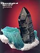
West slope, Schattig Wichel, Felli Valley, Reuss Valley, Uri, Switzerland