| Locality type: | Alpine Pasture |
| Classification |
|---|
|
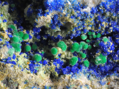
| Species: | Malachite |
| Formula: | Cu2(CO3)(OH)2 |
| Confirmation |
|---|
|
| Validity: | Believed Valid |
| Associated Minerals Based on Photo Data: |
|---|
|
| Azurite | ⓘ15 photos of Malachite associated with Azurite at this locality. |
| Brochantite | ⓘ6 photos of Malachite associated with Brochantite at this locality. |
| Theisite | ⓘ2 photos of Malachite associated with Theisite at this locality. |
| Adamite | ⓘ1 photo of Malachite associated with Adamite at this locality. |
| Data |
|---|
|
| Mineral Data: | Click here to view Malachite data |
| Locality Data: | Click here to view Unterbuchach Alp, Kirchbach, Hermagor District, Carinthia, Austria |
| Photo Gallery | View Gallery (11 photos) |
| Data Identifiers |
|---|
|
| Mindat Occurrence Record ID: | 204248 |
| Long-form Identifier: | 1:3:204248:0 |
| GUID (UUID V4): | 4a47c3c8-0fe1-4ee4-8fbb-1b6a99820a82 |
| Nearest other occurrences of Malachite |
|---|
|
|
| 3.1km (1.9 miles) | ⓘRio Sglirs, Paularo, Udine Province, Friuli Venezia Giulia, Italy |
| 8.7km (5.4 miles) | ⓘCasera Pramosio (Malga Pramosio)-Monte Avostanis/Blaustein area, Timau, Paluzza, Udine Province, Friuli Venezia Giulia, Italy |
| 9.0km (5.6 miles) | ⓘBlaustein, Plöcken pass area, Kötschach-Mauthen, Hermagor District, Carinthia, Austria |
| 9.2km (5.7 miles) | ⓘPramosio Quarry, Casera Pramosio (Malga Pramosio)-Monte Avostanis/Blaustein area, Timau, Paluzza, Udine Province, Friuli Venezia Giulia, Italy |
| 11.5km (7.1 miles) | ⓘElferspitz, Plöcken pass area, Kötschach-Mauthen, Hermagor District, Carinthia, Austria |
| 14.9km (9.2 miles) | ⓘCellon, Plöcken pass area, Kötschach-Mauthen, Hermagor District, Carinthia, Austria |
| 16.1km (10.0 miles) | ⓘSpinal da Ciare stream, Cercivento, Udine Province, Friuli Venezia Giulia, Italy |
| 16.2km (10.1 miles) | ⓘRio Crete Forade, Cercivento, Udine Province, Friuli Venezia Giulia, Italy |
| 17.1km (10.6 miles) | ⓘLanger prospect, Berg im Drautal, Spittal an der Drau District, Carinthia, Austria |
| 19.4km (12.1 miles) | ⓘJudengras Mine, Lower Wolay Alp, Podlanig, Kötschach-Mauthen, Hermagor District, Carinthia, Austria |
| References |
|---|
|
|


Unterbuchach Alp, Kirchbach, Hermagor District, Carinthia, Austria