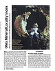
 | | Journal (article/letter/editorial) | | that bring together important locality data for Ohio minerals. It is a contri bution to the national...the Findlay Arch (northwestern Ohio) and Serpent Mound (southwestern Ohio) districts (Carlson 1990); thisvone...Kirwan Reservoir at mouth of Silver Creek near Edinburg, Portage County. Figure 1 (left). Rosanna Carlson...septarium, Copperas Mountain near Spargursville, Ross County. Ernest Carlson photo. Figure 3. Map showing mineral...in a northerly trending belt that runs from the Ohio River to Lake Erie (Monroeville and Spargursville |  | | Report (edition) | | GEOLOGICAL SURVEY 2045 MORSE RD., BLDG. C- 1 COLUMBUS, OHIO 43229-6693 (614) 265-6576 (614) 447-1918 (FAX)...L. Fox, MS, Seismologist Michael C. Hansen, PhD, Ohio Seismic Nelwork (OhioSeis) Coordinator An Equal... Minerals of Ohio by Ernest H. Carlson Bulletin 69 Second Edition STATE OF OHIO DEPARTMENT OF NATURAL...(formerly Stoneco, Inc.}, near Junction, Pau lding County, Ohio. Specimen is 3.8 x 2.4 cm with the largest crystal...citation: Carlson, E.H., 2015, Mineral s of Ohio (2d ed.): Columbus, Ohio Department of Natural Resources, Division |  | | Journal (article/letter/editorial) | | argillaceous rocks are represented by the Garden Creek Phyllite and Ramshorn Slate. Calcareous rocks are...Wood River area (box marked as Fig. 2), Beaver Creek area (box marked as Fig. 3), Carrietown area, and...the Wood River area showing the locations of Deer Creek, Bullion, Croesus, McCoy, Minnimoore, Silverstar...two-mica granite Thompson Creek, Deer Creek, McCoy, Croesus, Beaver Creek (Pilgrim, Silver King), Vienna...Vienna, Carrietown, Rooks Creek, Dead Wood, White Cloud Peak, Little Boulder Creek, Treasure Vault PennsylvanianPermian |  | | Report (issue) | | GEOLOGIC MAP OF THE BLACKBIRD CO-CU-AU DISTRICT, LEMHI COUNTY, IDAHO -114° 24’ 0.5” 45° 11’ 15.2” 30 Ycabs...80 36 35 70 42 35 40 k fault 20 40 Big Deer Cree 50 60 fault Ledge 27 80 White 80 Ybs...upper part of the Lake Mountain member of the Apple Creek Formation of Burmester and others (2016). ª ¬...Slip ge Led te Whi Little fault Cr e ek Deer Big NE RI CR DG EE E K PI CO BA LT J M URE...downloaded in PDF format from www.idahogeology.org. Deer Creek Fault ¬ Iron Lake thrust plate ª ª 45° 4’ |  | | Journal (article/letter/editorial) | | manganese at the junction of Deer Creek with the Snake River in Summit County, Colorado* P. K. THEOBALD...June 1962) Abstract-The oxidation of disseminated pyrite in relatively acid schists and gneisses of the...drainage basin. The adjoining drainage to the west, Deer Creek, is underlain by basic rocks, from which the...preciousmetal veins in the drainage basin of Deer Creek, it carries less metal than the Snake River....iron oxide quantities of the other metals. In Deer Creek manganese oxide is precipitated and large quantities |  | | Report (issue) | | . . . . . . . . . . . . . . . . . . . . . . 1 County Listings. . . . . . . . . . . . . . . . . . . .... . . . . . . . 4 Mineral Localities Listed by County . . . . . . . . . . . . . . . . . . . . . . . .... . . . . . . . . . . . . . . . . . . 7 Beaver County . . . . . . . . . . . . . . . . . . . . . . . ... . . . . . . . . . . . . . . . . . 7 Box Elder County . . . . . . . . . . . . . . . . . . . . . . . .... . . . . . . . . . . . . . . . . . . 10 Cache County . . . . . . . . . . . . . . . . . . . . . . . |  | | Report (issue) | | COBALT-COPPER DEPOSITS OF ~ BLACKBIRD DISTRICT lEMHI COUNTY, IDAHO by :r. 5. Vhay Geological Survey For...cobalt-copper deposits of the Blackbird district, Lemhi COunty, Idaho, has been re"leased for limited distribution... the principal ore minerals are ssociated w~th pyrite and pyrrhotite. The ore deposits occur in shear... deposit~ of the Blackbir~ ,I.st :n.ct~ ~emh1. County, Idano"p from the D1rector, U. So Geolog1cal Survey~...West Fork, and the few observations along Musgrove Creek, plate 1). It is a weak rock structurally, which |  | Lund, K., Tysdal, R. G., Evans, K. V., Kunk, M. J., Pillers, R. M. (2011) Structural Controls and Evolution of Gold-, Silver-, and REE-Bearing Copper-Cobalt Ore Deposits, Blackbird District, East-Central Idaho: Epigenetic Origins. Economic Geology, 106 (4) 585-618 doi:10.2113/econgeo.106.4.585 | Journal (article/letter/editorial) | | and late quartz veins contain chalcopyrite and pyrite, whereas intermediate-stage tourmaline-biotite...mine min Cu-Co±Au 4 Iron Creek depositt 5 Kitty Burton mine 6 McConn Creek deposi sit Au±Cu±Ag± 7 Salmon...Salmon Canyon Copperr Pb±Zn Company mine 8 Wo Woods Creek deposit REE, Th 9 Ulysses sses ses mine FIG. 1... 6 = Iron Creek prospect, 7 = Spring Creek deposits, 8 = Shoup area mines, 9 = Pine Creek mines, 10 =...= Diamond Creek mines, 11 = Copper King mine, 12 = Pope Shenon mine, 13 = Woods Creek deposit, 14 = McConn |  | | Report (volume) | | mine._______________________________________ Birch Creek district, Idaho__-_______._______________________-__...183 IV CONTENTS Mine descriptions Continued Deer Creek district, Montana_________________________ Divide...sections of the Trapper no. 1 claim, Beaverhead County, Mont__________________________ In pocket FIQTJEE...Idaho_____ 43. Geologic and index maps of the Birch Creek district, Montana______________ __ ._ 44. Geologic...Montana.. 45. Geologic and index maps of the Deer Creek district, Montana....__________._-__--__----------_---_-_--_ |  | | Report (issue) | | ........................................... 44 Pyrite .................................................epsomite, fluorite, marcasite, melanterite, millerite, pyrite, pyrrhotite, smythite, sphalerite, strontianite...examine a collection of geodes from Big Walnut Creek, Putnam County; and many quarry operators for granting...Indians knew of and used Wyandotte Cave in Crawford County (4).2 Ball (1941, p. 39) summarized the various...The Indians found that Wyandotte Cave, Crawford County, Ind., contained two desirable products, a jaspery |  | | Journal (article/letter/editorial) | | mineral has been mined quite extensively in Clay County, Alabama, from one end to the other. It is quite...ARKANSAS—Brown jasper pebbles have been found in a creek bed near Benton, Saline Co., Ark. ROCKS AND MINERALS...south of Antimony Peak, near Hollister, San Benito County, California. While it might sound like exaggeration...will contain all the above, and I almost forgot, pyrite xls. On Sultan Mt. the dumps yield the same thing...tiny brownish fluorite cubes, tiny brassy-yellow pyrite cubes, small brownish stilbite xls in dark gray |  | | Report (volume) | | .......... The Atlantic gold district, Fremont County, Wyo........................... Introduction............................................. Trail Creek group......................................................................................... Deer Creek district.......................................Chromite in Deer Creek canyon................................. Asbestos prospects east of Deer Creek.................... 79 Copper prospects on Cotton wood Creek......................... 80 Hazenville prospects |  | | Report (issue) | | Lightning Creek drainage basin 6 3. Map showing locations of data-collection sites in the Deer Creek and...Cherry Creek drainage basins 7 4. Map showing locations of data-collection sites in the Cow Creek drainage...concentration of dissolved solids in Little Cherry Creek near West Mineral, Kansas (07184240) 10 6. Graph...to concentration of dissolved solids in Cherry Creek near West Mineral, Kansas (07184220) 11 7. Graph...drainage basins of Lightning Creek, Deer Creek, Cherry Creek, and Cow Creek. Data from these sites, listed |  | | Report (issue) | | officio member MINERAL RESOURCE POTENTIAL OF PIUTE COUNTY, UTAH AND ADJOINING AREA by Eugene Callaghan ...This study of the mineral resources of the Piute County area, prepared under a Utah Geological and Mineralogical... . . . ... . . .. . . .. . .. . .. 114 Manning Creek . . . . . . . . . . . . . . . . . . . . . . .. 115...Mining District .... . . . . . . ... . . 119 Mill Creek Deposits . . . . . . . . . . . . . . . . . . . .... .. . . . ..... . . . . . . . . . .. 120 Bo x Creek Deposits . . . . ..... . . ... ...... 120 Sulfur |  | | Report (volume) | | -...........-..... .......................... Deer Creek fault and Charleston-Nebo thrust................................... Faulting south of Deer Creek fault ....................................................... Faulting north of Deer Creek fault .................................................... Jointing............................................. Dry Creek Canyon area................................................................................... Deer Creek (locality E)................................ |  | | Report (volume) | | ............................................... Ohio...................................................See Bauxite and Halloysite. Asbestos. Tallapoosa County, with corundum deposits near Dudleyville; not found...commercial quantity or quality. Asphalt. Colbert County, small quantity has been shipped from near Leighton;...following localities : Bibb County, Pratts Ferry; Calhoun County, near Tampa; Clay County, T. 20 S., R. 7 E.;...; Jefferson County, at Ely ton; Lee County, at Chewacla lime works"; St. Clair County, at Greensport; |  | | Report (volume) | | Peaks fault________________________--_-_-_-_--_ Deer Creek shear zone_________________________________ Mineral...________________________ Mineralization along Deer Creek shear zone_______-___-__-__-_ Veins south of...prospect.___________________________________________ Deer Creek prospect______________________________-_-___-_Mountain...were found along the Spanish Peaks fault and the Deer Creek shear zone, and two small altered zones were...construction in 1965, from the county road along Spanish Creek to the Spanish Creek Ranger Station, will provide | | | Report (issue) | | Mining districts Gibbonsville Mining District Indian Creek Mining District Mineral Hill Mining District Mackinaw...Mining District Blackbird Mining District Wilson Creek Mining District Yellowjacket Mining District Gravel...Mining District Carmen Creek Mining District Eldorado Mining District Pratt Creek Mining District McDevitt...east-central Idaho. Most of the Forest is in Lemhi County; only a small portion falls within Idaho and Valley...in dark grey siltite and argillite of the Apple Creek Formation. As a result of this study, 26 areas have |  | | Report (volume) | | North Dakota... .Dr. A. G. Leonard, Grand Forks. Ohio.............Prof. John A. Bownocker, Columbus. Prof...See Bauxite and Hallpysite. Asbestos. Tallapoosa County, with corundum deposits near Dudleyville; not found...commercial quantity or quality. Asphalt. Colbert County, small quantity has been shipped from near Leighton;...following localities: Bibb County, Pratts Ferry; Calhoun County, near Tampa; Clay County, T. 20, Pv. 7 E.; Jefferson...Jefferson County, at Elyton; Lee County, at Chewacla lime works; St. Clair County, at Gfeensport; Shelby |  | | Report (issue) | | Reconnaissance Geology of Western Mineral County Montana By ROBERT E. WALLACE and JOHN W. HOSTERMAN ...geologic structure and mineralogy of western Mineral County, Mont., as determined by a 'series of traverses...___-_-______________Tamarack Creek fault_______------__________.____________ Silver Creek fault_____.__-___._______________...fault____.___-_-_---______-_-__-_______-___ Placer Creek fault-------_------_---_--____-_-_-______---_The...Lookout anticline ______________________ Swamp Creek anticline_-__--__----_--_----_-_-_-______._.-Cleavage |  | | Report (volume) | | deposits.____________________________ Disseminated pyrite deposits _______________________ Contact-metamorphic...area________ II. A, The upper part of the valley of Rock Creek; B, Lee Mountain and surrounding hills-____________________...quartzite on upper Ash Creek; B, Ripple-marked Cambrian quartzite on upper Ash Creek _ ___ ___ V. A, Mottled...quartzite on upper Ash Creek; B, Tornado limestone in the box canyon on upper Ash Creek-______ VI. A, Coarse...Coarse Cretaceous conglomerate on upper Ash Creek; B, Coarse Cretaceous conglomerate on Gila River above |  | | Book (edition) | | LAKE CITY, UTAH. MINERAL LOCALITIES. BEAVER COUNTY. (Vy Beaver City, near; hyalite, banded in brownish...covellite, copper, limonite, malachite, molybdite, pyrite. Bradshaw District; aragonite, aurichalcite, cerussite...almandine garnet, barite, bismuth - inite. Indian Creek; gold. Mooney Springs; topaz. Rock Corral; 9 miles...bismite, bismutite. BOX ELDER COUNTY. Copper Mountain Mine; azurite, Dove Creek; gold, garnet. cuprite, malachite...petroleum in shale. Park Valley Mines; galena, gold, pyrite; monazite (?) at Century Mine. Sierra Madre District; |  | | Report (volume) | | ......................... 240 Arizona: The Deer Creek coal field, by Marius E. Campbell .............between Silver Peak and Candelaria, Esrneralda County, by J. E. Spurr .................................southeastern margin of the Wilmore Basin, Cambria County, by Charles Butts ............................... Clinton County, by M. L. Fuller.............. Oil and gas fields of eastern Greene County, by Ealph....................... Pennsylvania: Clays of the Ohio Valley in Pennsylvania, by L. H. Woolsey....... |  | | Journal (article/letter/editorial) | | (about 19131, Esterbrook copper district, Albany County. John Taylor collection. An ideal and inexpensive...“The Copper Mountain Pegmatite District, Freniont County, Wyoming” and was in the JulylAugust 2001 issue...most notable ones. The localities are listed by county and then in alphabeticnl order. Where numerous...names are from Hausel (1986). Localities by County Albany County Allanite pegmatite, 12 miles W of Bosler...s, ColoradoWyoming State Line district, Albany County: largest crystal is approximately 0.Y carat. Karl |  | | Report (volume) | | 763 ARAVAIPA AND STANLEY MINING DISTEICTS GKAHAM COUNTY, ARIZONA BY CLYDE P. ROSS WASHINGTON GOVERNMENT..._____________________________ 8 Mescal Range and Deer Creek basin___________________ 10 Santa Teresa Mountains...of the Gila formation on the east side of Turkey Creek; B, Cliff of conglomerate of the Gila formation...THMRAYAIPA AND STANLEY MINING DISTRICTS, GRAHAM COUNTY, ARIZONA By CLYDE P. Ross SUMMARY The region in...argentite in it, chalcopyrite, sphalerite, and pyrite. There are contact-metamorphic deposits which have |
|


