 | | Report (issue) |
| OCCURRENCES IN UTAH by K. C. Bullock UTAH GEOLOGICAL AND MINERAL SURVEY a division of the UTAH DEPARTMENT... Frontispiece: Purple pit fluorspar pipe, Lost Sheep mine, Spar Mountain, Juab County. CONTENTS Page Dell...43 Floride Mine . . . . . . . . . . . . . . . . . . . . . . . . . . . . 43 Floride No. 1 Mine . . . . ...Floride No.5 Mine . . . . . . . . . . . . . . . . . . . . . . . 44 Floride No. 13 Mine . . . . . . ..... . . 45 Floride No. 18 Mine ............ ·.......... 45 Fluorine Queen Mine . . . . . . . . . . . . |
 | | Journal (issue) |
| Famous mineral localities: the Gold Hill mine, Tooele County, Utah ................................... S. Wise The Wagon Wheel Gap fluorspar mine, Mineral County, Colorado ....................................33 by B. Cairncross The Jan Coetzee copper mine, Namaqualand, South Africa .......................right of amateur col lecting and recreational mining, and the use of public and private lands for educational...dark brown leather spine and black spine label with gold stamping. It is available in exchange for a $170 |
 | | Journal (issue) |
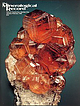
| bright orange wavellite crystals from the Phosphoria mine south of Bartow was a piece I had collected. (Continues...on page 2) Zalesiite frolll the Gold Hill Mine Toole County, Utah Paul M. Adams 126 South Helberta Avenue...Introduction The Gold Hill mine is located in northwest Utah about 30 miles southwest of Wendover, Utah. It is...different varieties of mixite occurred at Gold Hill. In the south pit they described pale green needles, associated...in quartz, either in the south pit or on the dumps. The Gold Hill mine is also the type locality for the |
 | | Report (issue) |
| Professor Edwin H . Oshier, Head of the Department of Mining Engineering, made the photographs included in this...7 Bibliography . . . . . 229 Appendix: 252 Mine Index iii NOTATIONS AND ABBREVIATIONS CHEMICAL...ELEMENTS Gold Silver Copper Iron Bismuth Selenium Tetradymite Argentite Chalcocite Bornite Galena Altaite...prospects in the lower Ludlow lignites. Harding County: 1. Abemathyite has been identified as a component...meta-uranocircite in uraniferous lignite at the Hilltop mine in sec. 12, Tl6N, R8E, in the Slim Buttes area. |
 | | Report (issue) |
| Deposits of the Osgood Mountains Quadrangle Humboldt County, Nevada GEOLOGICAL SURVEY PROFESSIONAL PAPER 431...Deposits of the Osgood Mountains Quadrangle Humboldt County, Nevada I By PRESTON E. HOTZ and RONALD WILLDEN...contact metamorphism, and deposits of tungsten, gold, and other minerals UNITED STATES GOVERNMENT...deposits of the Osgood Mountains quadrangle, Humboldt County, Nevada, by Preston E. Hotz and Ronald Willden...deposits of the Osgood Mountains quadrangle, Humboldt County, Nevada. 1963. (Card 2) 1. Geology-Nevada-Humboldt |
 | | Book |
| . . . . . . . . . . . . . . . . . . . . . . 3. Mining methods . . . . . . . . . . . . . . . . . . . ... . . . . . . . . . . . . . . . . 4. The company mine . . . . . . . . . . . . . . . . . . . . . . . ..... . . 9. Iron mining in the Forest of Dean .. ... .. .. ......... : . . . . . 10. Gold mines in South... . . . . . . . . . . . . . . . . . . 12. A lead mine in North Wales . . . . . . . . . . . . . . . . ......... 14. A Peak District lead mine .................................. 15. A mine valley in the mid |
 | | Book (volume) |
| been an indefatigable researcher and collector of mining history. Among his specialties may be mentioned...fate of the Sterling mine in Ogdensburg, New Jersey, and his intense interest in mining history led him to...to purchase the mine in order to form a living museum so that it would remain accessible to the mineralogical...mineralogical community. Through his efforts, the Sterling mine has been declared a national historic landmark....a story to tell concerning Maine's minerals and mining history. The ranks of invited contributors have |
 | | Report (issue) |
| Geologic 62 Series Geology oftheAndover Mining District, Sussex County, New Jersey" by P. K. Sims and B. F...more than a mile, ore deposits of the Andover district were presence of zinc, lead and copper sulfides... and the known extension of the ore made this district an attractive one for prospecting. For that reason...The Andover-Sulphur Hill area ....................................... The Tar Hill-l_mgo_re area ......... 36 Sulphur Hill mine ................................................. Tar Hill mines ......... |
 | | Report (volume) |
| the North Absaroka Wilderness and Vicinity, Park County, Wyon1ing By WILLIS H. NELSON and HAROLD J. PROSTKA...THE SUNLIGHT MINING REGION and GEOLOGY AND MINERALIZATION OF THE COOKE CITY MINING DISTRICT By JAMES E...the North Absaroka Wilderness and vicinity, Park County, Wyoming. (Studies related to wilderness-wilderness...mineral survey of the North Absaroka Wilderness, Park County, Wyoming, and some adjoining national forest lands...S. Bureau of Mines ............... 33 Sunlight mining region ....................................... |
 | | Report (volume) |
| __________-__--___-_--.-_ _ _.- _ Mineral potential of the district- __-___-_._-____-_-.________-__-_ Mines, prospects...Bunch Hollow mine, Claiborne County. 3. Geologic map and section of the New Prospect mine (Leadmine Bend)...prospects, Union County. 4. Maps of the Ritchie (Lynch) prospect, Claiborne County. FIGURE 1. Sketch...(Cumberland) thrust block. The main part of the district, 6-7 miles wide, extends northeast along the crest...River area, in western Claiborne County and northeastern Union County, is one of the most pervasively |
 | | Book |
| Geology of the Bristol district BRITISH GEOLOGICAL SUR VEY G. A. KELLAWAY F. B. A. WELCH CONTRIBUTORS...Ivimey-Cook M. Mitchell and Geology of the Bristol district Memoir for 1:63 360 geological special sheet (England...and WELCH, F. B. A. 1993. Geology of the Bristol district. Memoir of the British Geological Survey. Authors...edition, in press Memoirs Geology of the Bristol district: the Lower Jurassic rocks (Bristol geological...Chepstow (233, 250), 1961 Geology of the Malrnesbury district (251 ), 1977 Geology of the country around Wells |
 | | Report (volume) |
| periods of exploratIon that ultimately led to a mining "boom ll in the 1950 IS. Since I ts meager start...Tallahassee Creek distrIct in Fremont County. Uranium, recoverable by solution mining of Upper Cretaceous...evaluated In Weld County. VBlntype uran I urn occurrence 5 are typ I fled in Je f farson County by the Schwartzwal...Schwartzwal der Mi ne, the largest uranium mine In Colorado. Part 2 contains in the bibliography of approximately...occurrences In the state, with cross-Indexes by county, host rock, and the special categoriesof "Front |
 | | Journal (issue) |
| ....................................... Copper County Mineral Retreat Christine Chritchley 41 .........mid-step whilst walking alongside me. Studies in the mining industry show that the rate of temperature increase...degrees, and therefore the temperature 'down the pit' is likely to be in the mid to high forties. This...each day Possible sites include: Great Orme Copper Mine (entrance fee) Alderley Edge Mines (insurance fee)...Society and Southern Branch Field Trip to Moons Hill Quarry Material collected on this visit, from a |
 | | Report (issue) |
| analyses of rocks and minerals from Pilot Knob Mine, Iron County, Missouri............................ Spectrographic...ore and gangue minerals from Iron Mountain Mine, Iron County, Missouri................... Spectrographic...rocks and minerals from Pea Ridge Iron Mine, Washington County, Missouri............ Whole-rock chemical....... Analyses of samples from Silver Mine area, Madison County, Missouri...............................analyses of iron oxides and sulfides, Steelville district, Missouri............................... Spectrographic |
 | | Report (issue) |
| _______________________ Mining, preparation, and uses of mica. _____________ Mining.___________________________________...mines and prospects___________________ 60 Addie tin mine._________________________________ 60 Ajax claim...___________60 Aladin mica mine by J. W. Adams____________ 60 Ann mica mine by T. A. Steven_________________...Steven_________________ 61 Antler mica mine.._-___--__--__-___-_-_-___-___ 64 Apex claim.___-__________-_-----_---_--_-____64...No. 2 claims.___________________ 65 Ballard mica mine._____________________________ 65 Beecher Lode by |
 | | Report (issue) |
| VOLUME I: SILVER CITYWAR EAGLE MOUNTAIN AREA, OWYHEE COUNTY, IDAHO JOHN KAUFFMAN, EARL H. BENNETT, and VICTORIA...VOLUME I: SILVER CITYWAR EAGLE MOUNTAIN AREA, OWYHEE COUNTY, IDAHO JOHN KAUFFMAN, EARL H. BENNETT, and VICTORIA...MINES.. . . . . . . . . . . . . . . . 2 1.4.1 Acid Mine Drainage. . . . . . . . . . . . . . . . . . . .... . . 7 1.5.3.1 Soil, Rock, Stream Sediment, and Mine Waste Sampling Procedures. . . . . . . . . . . ... . . . . . . . . . . . . . . . . . . . 19 2.5.2 Mine Waste Samples.. . . . . . . . . . . . . . . . . |
 | | Journal (volume) |
| IV. the Geological traversing Limestone in the County of President of the Geological Society III. -...called VI. Cornwall. By in the Veins of the Mine John Williams, Esq. - Geological Society p. ...the Tavistock Canal, through Morwel Down, in the County of Devon. By John Taylor, Esq. Treasurer - of...Gilby, M.D. p. 210 X. On XI. Observations on the Hill of Kinnoul, in Perthshire. By John Mac Culloch,...give a general outline of the several formations district. I have added short descriptions of the principal |
 | | Journal (article/letter/editorial) |
| SP4 0DD, UK ABSTR ACT Mississippi Valley type galena deposits emplaced into Carboniferous limestones...erosion of the intervening strata. Oxidation of galena initiated the deposition of manganate minerals...leadmanganate deposits causing decomposition of the galena and creating the conditions which led to the formation...sequence’ of minerals found at the Mammoth-St. Antony Mine. The complexity of these formation processes probably...limestone, causing low-T (surface) oxidation of the galena. The presence of an oxidizing environment triggered |
 | | Report (issue) |
| DESCRIPTIONS OF PROPERTIES Dudgeon Boicey Zenith Mine Dubblestein Thomas Legris Tooey's Lake Gorman Lake...(Madawaska) Mine Goldhawk Greyhawk Howard Kerr Lockwood York River Barr Feldspar Quarry Percy Spain Mine Peler-Rock...Goshen A Goshen B Canadian Beryllium Mines Jamieson Mine Price Universal Light Metals O'Brien-Fowler South...Bartlett Mine Carr Ferrill Genesee No. 2 Mine Genesee No. 2 Mine (South Showing) MacDonald Mine Mell-Quirke...Peter-Rock (East Showing) Plunkett North Mine Plunkett South Mine H. Quirk Robson South State (North) South |
 | | Report (issue) |
| DEPOSITS IN THE DRIPPING SPRING QUARTZHE, GIIA COUNTY, ARIZONA By H. C. Granger and R« B. Raup Prepared...9* Index map shoving uranium deposits in Gila County.; Arizona. Geologic maps of adits 1 and 2, Donna...Lee deposits. Geologic map of adit and prospect pit, Iris deposit. Geologic maps of adits 1, k, and 5;...and section of workings and drill holes, Lucky Boy mine. Geologic map of adits 1, 2, and 7, Red Bluff deposits...deposits. Composite geologic map of the Sue mine* Geologic maps and sections of the Workman adits 2 and |
 | | Journal (volume) |
| Esq. F.R.S. &c. . p. 3. Notice respecting a Copper Mine at Cally in Kircudbrightshire. By John Taylor, Esq...176 XV. Observations on the South-western Coal District of England. By the Rev. W. Buckland, B.D. F.R...empire, taken altogether, contains five principal mining districts; two in Europe, two in Asia, and one...in European Russia are the northern or Finnish district, and the cen tral: the former reaching from the...Geology of Russia. - iron. The border or Oural district comprehends all the Oural mountains as far as |
 | | Book |
| pa1tnership between DAA Halsgrove Ltd and Somerset County Council (Directorate of Cultme and Heritage) www...INDUSTRIAL AGE SOMERSET STONE LIME BURNING MINING FOR METALS COAL MINING AND OTHER FUELS CLAY INDUSTRIES CORN...152 157 ACKNOWLEDGEMENTS include the Chard and District Museun1 , Radstock Mu seum, Somerset Studies L...taken me to so1ne truly beautiful parts of the county and the rich diversity of its rural landscape,...lilnestone and freestone .. . Ham Hill stone is found in this county and Doulting stone ... The iron ore |
 | | Book |
| \ Geology of the Bristol district: the Lower Jurassic rocks The Lower Jurassic of the Bristol area...passes on to the shelf with hardly any change. The Middle and Upper Lias were largely removed from the area...DONOVAN and G. A. KELLAWAY Geology of the Bristol district: the Lower Jurassic rocks Memoir for 1:63 360...AND KELLAWAY, G. A. 1984. Geology of the Bristol district: the Lower Jurassic rocks. Mem. Br. Geol. Surv...21 Lower Lias 24 49 Chapter 3 11 Middle and Upper Lias Middle Lias 49 Local details 49 Upper Lias |
 | | Report (edition) |
| SOMERSET COUNTY LIBRARY This book must be returned on or before the latest date marked below. DATE...BRITISH REGIONAL GEOLOGY BRISTOL AND LOUCESTER DISTRICT by F. B. A. WELCH, B.Sc., Ph.D. and R. CROOKALL...MILLSTONE GRIT ’ : Upper Drybrook Sand stone and Brandon Hill Grit 26 COAL MEASURES : Conditions of formation...including Rhaetic 43 XI. LIAS : Lower Lias ; Middle Lias ; Upper Lias .. 51 XII. INFERIOR OOLITE...deposition ; the Bajocian Transgressions ; Lower and Middle Inferior Oolite ; Upper Inferior Oolite .. .. |
 | | Book |
| coadju¬ tor, and how comparatively little my own (for mine has chiefly been that of a compiler), I have not...regular induction of them applied not to a limited district, but extending to the whole of this country, may...the metallurgical operations prosecuted in the mining districts, subjects which will be found useful...d the ironsand which occurs on the west of this county. Near Gamlingay, read Newmarket. Between the chalk...the iron sand, which occurs on the west of this county near Gamlingay —— 167-21, after encrinites, &c |


