 | | Journal (article/letter/editorial) | | [University of Connecticut] at 20:42 14 January 2015 South Dakota is perhaps best known for its pegmatites, which...Hills are responsible for the accessibility of South Dakota’s itbundant and diverse mineral locations...to be made. The most complete mineralogy of South Dakota and the Black Hills is found in Roberts and...965). Some uncited mineral species are from the South Dakota School of Mines Museum of Geology. Noteworthy...FiridofGt~rnSphultirite ut IIIP Bulinut Zinc Mine, St. Luwrence County, tditor of NPW b r k ” unrl iipptwwl in the No~~er |  | | Report (issue) | | STATE OF SOUTH DAKOTA Nils Boe, Governor MINERALOGY OF THE BLACK HILLS by WILLARD LINCOLN ROBERTS...Associate in Mineralogy Museum of Geology, South Dakota School of Mines and Technology and GEORGE RAPP...Department of Geology and Geological Engineering, South Dakota School of Mines and Technology With the Editorial...Mineralogy South Dakota School of Mines and Technology BULLETIN NUMBER 18 of the South Dakota School of...of Mines and Technology Rapid City, South Dakota PUBLICATIONS STAFF F. L. Partlo J. T. Thomas President |  | | Report (volume) | | ........................................ North Dakota........................................................ South Carolina......................................:.................... South Dakota..........Arkansas, California, Colorado, New Mexico, Oregon, South Dakota, Tennessee, and Texas; to list all the literature...Catalogue of the mineral localities of South Carolina: South Carolina Geol. Survey, ser. 4, Bull. 2,...1908. Scott, Samuel, Map of the Black Hills of South Dakota and Wyoming, with full descriptions of mineral | 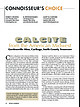 | Huizing, Terry E., Richards, R. Peter, Clifford, Janet H., Cook, Robert B. (2017) Connoisseur's Choice: Calcite from the American Midwest, Gordonsville Mine, Carthage, Smith County, Tennessee. Rocks & Minerals, 92 (1) 46-63 doi:10.1080/00357529.2017.1241690 | Journal (article/letter/editorial) | | American Midwest Gordonsville Mine, Carthage, Smith County, Tennessee C alcite is ubiquitous in the American...Tennessee Lead-Zinc district near Carthage in Smith County. Calcite from this locality is noted for high luster... which for much of Paleozoic time, was located south of the equator (Reshkin 1986). The lower Midwest...for the growth of unusu- ally large crystals. Anhydrite nodules (proto-geode structures) formed in shallow...fracturing, and uplift of the Ouachita Mountains to the south and the Appalachian Mountains to the east, introduced |  | | Report (issue) | | Denver, Colorado 9 ^University of South Dakota Vermillion, South Dakota INTRODUCTION This bibliography...references on geology of the Black Hills in South Dakota and Wyoming. For purposes of this report, the... the area does not include the Bad Lands of South Dakota nor the bulk of the Powder River Basin in Wyoming...included in the bibliography. References for South Dakota are more complete than those for Wyoming. Both...geology of the Black Hills National Forest, South Dakota and Wyoming, with a section on Salable commodities |  | | Report (volume) | | ........Prof. B. L. Miller, Lehigh University, South Bethlehem, Pa. Florida............Dr. E. H. Sellards...Carolina.. .Dr. Joseph Hyde Pratt, Chapel Hill. North Dakota... .Dr. A. G. Leonard, Grand Forks. Ohio......... Brown, Providence. South Carolina.. .Dr. Earle Sloan, Charleston. South Dakota... .Prof. E. C. Perisho...See Bauxite and Hallpysite. Asbestos. Tallapoosa County, with corundum deposits near Dudleyville; not found...commercial quantity or quality. Asphalt. Colbert County, small quantity has been shipped from near Leighton; |  | | Report (volume) | | National Forest, South Dakota and Wyoming U.S. GEOLOGICAL SURVEY BULLETIN 1580 SOUTH DAKOTA WYOMING I -«*&...Geology of the Black Hills National Forest, South Dakota and Wyoming We st from. Washington SHOWING...Geology of the Black Hills National Forest, South Dakota and Wyoming By ED DEWITT, J. A. REDDEN, ANNA...potential of the Black Hills National Forest, South Dakota and Wyoming, was made to assist the U.S. Forest...rugged, timbered land in the Black Hills of South Dakota and Wyoming and the Bear Lodge Mountains of |  | Brown, D.L., Blankennagel, R.K., MacCary, L.M., Peterson, J.A. (1982) Correlation of paleostructure and sediment deposition in the Madison limestone and associated rocks in parts of Montana, North Dakota, South Dakota, Wyoming, and Nebraska. Open-File Report Vol. 1982 (82-906) US Geological Survey doi:10.3133/ofr82906 | Report (issue) | | ASSOCIATED ROCKS IN PARTS OF MONTANA, NORTH DAKOTA, SOUTH DAKOTA, WYOMING, AND NEBRASKA U.S. GEOLOGICAL...ASSOCIATED ROCKS IN PARTS OF MONTANA, NORTH DAKOTA, SOUTH DAKOTA, WYOMING, AND NEBRASKA By D. L. Brown, R...structural elements in parts of Montana, North Dakota, South Dakota, Wyoming and Nebraska. 2. Map showing location...for study area in parts of Montana, North Dakota, South Dakota, Wyoming, and Nebraska. 3. Map showing thickness...lowermost Ordovician) in parts of Montana, North Dakota, South Dakota, Wyoming, and Nebraska. 4. Map showing rock |  | | Report (volume) | | Highway 49 (Skyway Road) near town of Abel, Cleburne County. Absaroka Supergroup/Volcanic Supergroup U ABRK03...volcanic field, Yellowstone National Park, Park County, Wyo. Academy Church Shale Member (Springer Formation)...W1/2NW1/4NE1/4SE1/4 sec. 1, T. 3 s., R. 2 E., Carter County. Adams Formation ADMS01 1. Holocene 2. Alaska (SE)...Quadrangle, lat 45° N., long 70°50'-55' W., Oxford County. Adamstown Member (Frederick Limestone) U ADMS06...section W of Lime Kiln in Frederick Valley, Frederick County. Named for town of Adamstown. Adobe Town Member |  | | Book (edition) | | Museum of Geology South Dakota School of Mines & Technology Rapid City, South Dakota GEORGE ROBERT RAPP...the Fuernrol No. 2 mine, Temple Mountain, Emery County, Utah; also sparsely disseminated in uraniferous...Cave Hills and Slim Buttes areas, Harding County, South Dakota. BEST REF. IN ENGLISH: Thompson, M. E.,...Little Emma mine, Clear Creek County; at the Enterprise n1ine, Dolores County; and at the Double Header lode...lode , Su1nmit County . rt is also found in Canada, Mexico, Czechoslovakia, and Germany. Acanthite is |  | Brown, D.L., Blankennagel, R.K., MacCary, L.M., Peterson, J.A. (1984) Correlation of paleostructure and sediment deposition in the Madison Limestone and associated rocks in parts of Montana, North Dakota, South Dakota, Wyoming, and Nebraska. Professional Paper 1273b. US Geological Survey doi:10.3133/pp1273b | Report (issue) | | Associated Rocks in Parts of Montana, North Dakota, South Dakota, Wyoming, and Nebraska U.S. GEOLOGICAL SURVEY...Associated Rocks in Parts of Montana, North Dakota, South Dakota, Wyoming, and Nebraska By D. L. BROWN, R...ROCKS IN PARTS OF MONT ANA, NEBRASKA, NORTH DAKOTA, SOUTH DAKOTA, AND WYOMING U.S. GEOLOGICAL UNITED ...associated rocks in parts of Montana, North Dakota, South Dakota, Wyoming, and Nebraska (Geological Survey...Branch of Distribution U.S. Geological Survey 604 South Pickett Street Alexandria, VA 22304 I. 83--600277 |  | | Report (volume) | | Selected Annotated Bibliography of Gypsum and Anhydrite in the United States and Puerto Rico By CHARLES...occurrences, origin, technology, and uses of gypsum and anhydrite UNIT.ED STATES GOVERNMENT PRINTING OFFICE, WASHINGTON...Selected annotated bibliography of gypsum and anhydrite in the United States and Puerto Rico, by Charles...1105) 1. Gypsum-Bibl. 2. Gypsum-U.S. 3. Anhydrite--Bib!. 4. Anhydrite-U.S. I. Jaster, Marion Charlotte, 1896(Series)... SELECTED ANNOTATED BIBLIOGRAPHY OF GYPSUM AND ANHYDRITE IN THE UNITED STATES AND PUERTO RICO By CHARLEs |  | | Journal (article/letter/editorial) | | prevail in portions of eight States from North Dakota on the northeast to Arizona on the southwest (Fig...collapse syncline. 1101 29. Synclinal collapse south of circular col1105 lapse of Figure 28 30. Collapse...50 —H 1077 /MONTANA / :'#r—(•7^ ! —45'- 5. DAKOTA Sundance :.• : ;6KC£HKllfEK Rawlinfe .••. % |...Orphan Mine, South side of Grand Canyon, Arizona Lisbon Valley, Utah, Mi Vida Mine, South of La Sal Vein...impressive area of carbonate emplacement is exposed south of the main collapse on Temple Mountain, Utah (PL |  | | Book (volume) | | Guide for Rock Hounds in the United States SOUTH DAKOTA This northwestern Great Plains state varies...western counties of Lawrence, Meade, Custer and Pennington the land rises abruptly into the 6,000 sq. mi...Alleghenies, culminate in Harney Peak in southern Pennington Co. At 7,242’ this peak is the highest point...rising granite mass intruded the famed Cretaceous Dakota sandstone, which underlies most of the Great Plains...continental seas were advancing from the south, the Dakota sandstone represents topset beds, wave reworked | 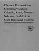 | Hill, Thelma P., Werner, Marian A., Horton, M. Julia (1967) Chemical composition of sedimentary rocks in Colorado, Kansas, Montana, Nebraska, North Dakota, South Dakota, and Wyoming. Professional Paper 561. US Geological Survey doi:10.3133/pp561 | Report (issue) | | Colorado, Kansas, Montana Nebraska, North Dakota South Dakota, and Wyoming GEOLOGICAL SURVEY PROFESSIONAL...Colorado, Kansas, Montana Nebraska, North Dakota South Dakota, and Wyoming Compiled by THELMA P. HILL...samples from Colorado, Kansas, Montana, Nebraska, South Dakota, and Wyoming, containing more than 75 percent...Dakota___________________________________________________ 6. South Dakota and Wyoming..___________________--_________...of samples from Colorado, Kansas, Montana, North Dakota, and Wyoming, containing uncombined silica and |  | | Report (issue) | | Southwestern Flank of the Black Hills Uplift, South Dakota U.S. GEOLOGICAL SURVEY BULLETIN 1917-S Chapter...Southwestern Flank of the Black Hills Uplift, South Dakota By DAVID J. DAHLSTROM and JAMES E. FOX A multidisciplinary...southwestern flank of the Black Hills uplift, South Dakota / by David J. Dahlstrom and James E. Fox. p...Lakota Formation, Custer and Fall River Counties, South Dakota. FIGURES 1. Index map of 7.5-minute quadrangles...Southwestern Flank of the Black Hills Uplift, South Dakota By David J. Dahlstrom 1 and James E. Fox 2 Abstract |  | | Report (issue) | | SURVEY Locatable Mineral Reports for Colorado, South Dakota, and Wyoming provided to the U.S. Forest Service........ . . ............ 10 Pike National Forest County of El Paso (Black Forest) Land Exchange Offer ...Creek Land Exchange Offer .............. 153 SOUTH DAKOTA ............................................................. Black Hills National Forest South Dakota Department of Transportation Land Exchange Offer...upper South Fork Mineral Creek area (Neubert and others, 1992, p. 197) ................... SOUTH DAKOTA |  | | Report (volume) | | NE Quadrangle Fall River and Custer Counties, South Dakota GEOLOGICAL SURVEY BULLETIN Prepared on behalf...NE Quadrangle Fall River and Custer Counties, South Dakota By GARLAND B. GOTT and ROBERT W. SCHNABEL GEOLOGY...the Minnelusa formation, Weston County, Wyo., and Fall River County, S. Dak., compared to an analysis...QUADRANGLE, FALL RIVER AND CUSTER COUNTIES, SOUTH DAKOTA BY GARLAND B. GOTT AND ROBERT W. SCHNABEL ABSTRACT...Kiver County, S. Dak., but a strip about 1% miles wide along the north edge is in Ouster County, S. Dak |  | | Book | | Iaria from the Howard-Montgomery quarry, Howard County, Maryland (by J. S. White) 25:53-54 AFGHANISTAN...Iron-manganese phosphates of the Williams pegmatites, Coosa County, Alabama (by P. B. Leavens & T. A. Simpson) 6:66-73...ALICE GLORY HOLE The Alice glory hole, Clear Creek County, Colorado (by T. A. Hanson & W. B. Craft) 18:185187...--and W. Hunt: The Tonopah-Belmont mine, Maricopa County, Arizona 19:139-144 ALLGOOD, GENNE MYERS --and...Allgood, J. Pradenas: Gold occurrences in Tuolumne County, California 18:41-45, 18:62-64 --with W. H. Wilkinson |  | | Book (edition) | | Utah; (lower /eft) rnodochrosite, N’Chwaning mine, South Africa; (lower left, center) wulfenite, Red Cloud...Lincoln. Encyclopedia of minerals Sagiiache County Pu blic Library Saguache , Colorado DEMCO For...Photo Editor: Wendell E. Wilson Library Saguache County Public Saguache, Colorado VAN NOSTRAND REINHOLD...England Thomas Nelson Australia 102 Dodds Street South Melbourne, Victoria 3205, Australia Nelson Canada...oil shale of the Green River Formation, Uintah County, Utah, associated with authigenic orthoclase, pyrite; | 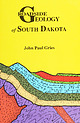 | | Book | | logyoO0000grie &N ROADSIDE % JEOLOGY of South Dakota John Paul Gries Mountain Press Publishing...Gries, John Paul, 1911- Roadside geology of South Dakota / John Paul Gries. p. cm. Includes bibliographical...(pbk. : alk. paper) 1. Geology—South Dakota—Guidebooks. 2. South Dakota— Guidebooks. I. Title. QE163.G68...interpreting the details of the surface geology of South Dakota. My model is Nathaniel Horatio Darton, geologist...depth to groundwater in the western half of South Dakota. Even in this day of gadgetry, field studies | | | Book (edition) | | Willard Lincoln. Encyclopedia of minerals ~~cbe County Public Library Saguache, Colorado OEMCO For Refere...England Thomas Nelson Australia 102 Dodds Street South Melbourne, Victoria 3205, Australia Nelson Canada...the Fuemrol No. 2 mine, Temple Mountain, Emery County, Utah; also sparsely disseminated in uraniferous...Cave Hills and Slim Buttes areas, Harding County, South Dakota. SELECTED REFERENCES: Thompson, M. E., Ingram...oil shale of the Green River Formation, Uintah County, Utah, associated with authigenic orthoclase, pyrite; |  | | Report (issue) | | Localization ofUraniu Deposits, Southern Black Hills, South Dakota and Wyon1ing GEOLOGICAL SURVEY Prepared on...of Uranium Deposits, Southern Black Hills, South Dakota and Wyoming By GARLAND B. GOTT, DON E. WOLCOTT...rocks in outcrop with anhydrite-bearing strata of the subsurface in Custer County, S. Dak.·-----------...Canyon, SE %. sec. 16, T. 3 S., R. 1 E., Custer County, S. Dak ______________________________________...LOCALIZATION OF URANIUM DEPOSITS, SOUTHERN BLACK HILLS, SOUTH DAKOTA AND WYOMING By GARLAND B. GOTTJ DoN E. |  | | Report (issue) | | GREAT PLAINS IN PARTS OF MONTANA, NORTH DAKOTA, SOUTH DAKOTA, AND WYOMING SUMMARY The Regional Aquifer...Great Plains in Parts of Montana, North Dakota, South Dakota, and Wyoming Summary By JOE S. DOWNEY and...Great Plains in parts of Montana, North Dakota, South Dakota, and Wyoming summary. (Regional aquifer-system...Aquifers Montana. 3. Aquifers North Dakota. 4. Aquifers South Dakota. 5. Aquifers Wyoming. I. Dinwiddie...Great Plains in parts of Montana, North Dakota, South Dakota, and Wyoming Summary: By Joe S. Downey and |  | | Report (issue) | | WATER YEAR 1994, BLACK HILLS HYDROLOGY STUDY, SOUTH DAKOTA U.S. GEOLOGICAL SURVEY Open File Report 96-399...cooperation with the SOUTH DAKOTA DEPARTMENT OF ENVIRONMENT AND NATURAL RESOURCES and the WEST DAKOTA WATER DEVELOPMENT...Water Year 1994, Black Hills Hydrology Study, South Dakota By Daniel G. Driscoll, Wendell L. Bradford,...Survey, the South Dakota Department of Environment and Natural Resources, and the West Dakota Water Development...Development District (which represents various local and county cooperators). This report is the second in a series |
|


