| Locality type: | Peak |
| Classification |
|---|
|
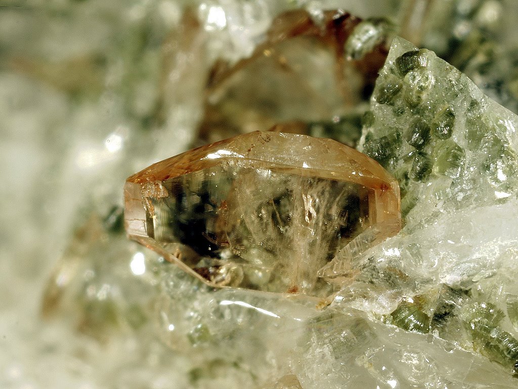
| Species: | Titanite |
| Formula: | CaTi(SiO4)O |
| Confirmation |
|---|
|
| Validity: | Believed Valid |
| Data |
|---|
|
| Mineral Data: | Click here to view Titanite data |
| Locality Data: | Click here to view Cima dei Covoni (Tristen peak), Mühlwald (Selva dei Molini), Puster Valley District, South Tyrol, Trentino-Alto Adige (Trentino-South Tyrol), Italy |
| Data Identifiers |
|---|
|
| Mindat Occurrence Record ID: | 392380 |
| Long-form Identifier: | 1:3:392380:1 |
| GUID (UUID V4): | 40ec8943-9f7c-4df9-99eb-230eaaf3e43b |
| Nearest other occurrences of Titanite |
|---|
|
|
| 3.6km (2.2 miles) | ⓘCesa (Zosen), Mühlwald (Selva dei Molini), Puster Valley District, South Tyrol, Trentino-Alto Adige (Trentino-South Tyrol), Italy |
| 3.7km (2.3 miles) | ⓘZösen Valley (Cesa Valley), Lappago (Lappach), Mühlwald (Selva dei Molini), Puster Valley District, South Tyrol, Trentino-Alto Adige (Trentino-South Tyrol), Italy |
| 4.3km (2.7 miles) | ⓘWeißenbach (Rio Bianco), Ahrntal (Valle Aurina), Puster Valley District, South Tyrol, Trentino-Alto Adige (Trentino-South Tyrol), Italy |
| 6.1km (3.8 miles) | ⓘCroda Bianca (Weißzint), South Tyrol, Trentino-Alto Adige (Trentino-South Tyrol), Italy |
| 6.6km (4.1 miles) | ⓘHorn glacier, Finkenberg, Schwaz District, Tyrol, Austria |
| 7.6km (4.7 miles) | ⓘEisbrüggalm (Malga Ponte del Ghiaccio), Pfunders Valley (Fundres Valley), Vintl (Vandoies), Puster Valley District, South Tyrol, Trentino-Alto Adige (Trentino-South Tyrol), Italy |
| 8.4km (5.2 miles) | ⓘMonte Cirne (Gschirn), Pfunders Valley (Fundres Valley), Vintl (Vandoies), Puster Valley District, South Tyrol, Trentino-Alto Adige (Trentino-South Tyrol), Italy |
| 8.4km (5.2 miles) | ⓘSchwarzenstein (Sasso Nero), Ahrntal (Valle Aurina), Puster Valley District, South Tyrol, Trentino-Alto Adige (Trentino-South Tyrol), Italy |
| 8.4km (5.2 miles) | ⓘSchwarzenstein (Schwarzenstein glacier), Mayrhofen, Schwaz District, Tyrol, Austria |
| 9.3km (5.8 miles) | ⓘUltramylonite occurrence, Finkenberg, Schwaz District, Tyrol, Austria |
| References |
|---|
|
|


Cima dei Covoni, Mühlwald, Puster Valley District, South Tyrol, Trentino-Alto Adige, Italy