 | | Journal (article/letter/editorial) |
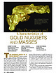
| Figure 1. Gold nugget, 7.67 troy ounces, Fairbanks mining region, Alaska, USA. Donated in 1977 by Arthur...Arthur Sexaur. University of Alaska Museum of the North specimen (No. AK 1271-G- 3), Robert Cook photo...photo. The Occurrence and Characteristics of GOLD NUGGETS AND MASSES ROBERT B. COOK Department of Geosciences...com HE COMMON IMAGE OF A GOLD NUGGET is that of a rounded piece of gold just plucked from a pan or...consistent with even the most generic definitions of gold nugget found in most general reference works and |
 | | Report (issue) |
| THE NOME REGION. By FRED H. MOPFIT. INTRODUCTION. The work of the Geological Survey in the Nome region...Brooks during the year following the gold discoveries on Anvil Creek in 1898. Their investigations, although...bench gravels and the probable presence of other gold-bearing beaches back of the present beach, whose...study of the occurrence and distribution of the gold. Detailed study of the region was made possible...accurate map representing an area which includes the beach from Cape Nome to a point 3 miles west of the |
 | | Report (issue) |
| forth is unnecessary. In trying to cover so large an area as the southern part of Seward Peninsula, the writer...of gold was won, to the end of the open season of 1908. a Brooks, A. H., Placer mining in Alaska: Bull... H., Gold mining.in Seward Peninsula: Bull. No. 284,190G, pp. 132-141. Moflit, F. H., The Nome region:...region: Bull. No. 314,1907, pp. 126-144. Smith, P. S., Gold fields of the Solomon and Niukluk River basins:...Smith, P. S., Geology and mineral resources of Iron Creek: Idem, pp. 157-103. Brooks, A. H., The Kougarok |
 | | Report (issue) |
| MINING IN SEWAKD PENINSULA, By FRED F. HENSHAW. GENERAL CONDITIONS. The mining industry suffered a general...during the season of 1909. The value of the total gold production fell from about $7,000,000 in 1907 and...determined, is given in the following table: Value of gold production in Seward Peninsula, 1897 to 1909. 1897...have been more severe than in any other year since mining began, more than a decade earlier. A comparison...the fourth week in July, 1908. The snow fall at Nome was 41 and 38.5 inches, respectively, for the winters |
 | | Report (volume) |
| PROGRESS OF INVESTIGATIONS OF MINERAL RESOURCES OF ALASKA IN 1906 BY ALFRED H. BROOKS AND OTHERS WASHINGTON.................................... Southeastern Alaska............................................ Yakutat-Alsek....................................... 16 Yukon district........................................................................................ 17 THE MINING INDUSTRY IN 1906, by Alfred H. Brooks.................................................. 22 Lode mining............................................... |
 | | Report (issue) |
| LODE MINING AND PROSPECTING ON SEWARD PENINSULA. By J. B. MERTIE, Jr. INTRODUCTION. The lodes of Seward...undeveloped. The Big Hurrah mine, in the Solomon district, produced gold from 1903 to 1907 but has not...shipments of gold ore have been made from the Sliscovich mine, on Manila Creek, in the Nome district, but these...two properties, gold lode development is still in the stage of prospecting. Lode mining of some of the...published later. GOLD. SLISCOVICH. The Sliscovich mine, near the head of Manila Creek, has been described |
 | | Report (volume) |
| SOLOMON AND CASADEPAGA QUADRANGLES SEWARD PENINSULA ALASKA BY PHILIP S. SMITH WASHINGTON GOVERNMENT PRINTING.................................................. Nome group ................................................................ 137 137 .137 History of mining......................................................-.........".........-..... 143 Big Hurrah mine............................................. Miscellaneous.............................. General methods of mining placers................................ Classification |
 | | Report (volume) |
| DIRECTOR THE GOLD PLACERS OF PARTS OF SEWARD PENINSULA, ALASKA INCLUDING THE NOME, COUNCIL, KOUGAROK,...H. BROOKS__________________ DEVELOPMENT OF THE MINING INDUSTRY, BY ALFRED H. BROOKS_____ Foreword __...13 J9 24 28 Growth of mining from 1902 to 1904___________________ 31 Mining developments in 1905-6_...Kuzitrin formation___________.______________.._ 69 Nome group______________________________ 70 General ...classification of placers___________________ 114 Gold in bed rock_______________________________ 116 |
 | | Report (issue) |
| compiled from various sources, of the amount of gold produced by the entire peninsula for the year 1907...production of gold in Seward Peninsula from 1897, the first year in which any notable amount of gold was won...placers of the ancient beach about 3 miles north of Nome. Although extensions of this beach have been uncovered...Placer mining in Alaska: Bull. U. S. Geol. Survey No. 259, 1905, pp. 19-24. Mofflt, F. H., Gold mining... pp. 132141; The Nome region : Bull. No. 314, 1907, pp. 126-144. Smith, P. S., Gold fields of Solomon |
 | | Report (issue) |
| OF SURFACE-WATER RECORDS TO SEPTEMBER 30, 1955 ALASKA ~OPERTY Of: U. S. GECJLCCICAL p U 8 Ll C II...INDEX OF SURFACE-WATER RECORDS TO SEPTEMBER 30,1955 ALASKA By E. G. Bailey Washington, D. C., 1956 INDEX... INDEX OF SURFACE-WATER RECORDS TO SEPTEMBER 30,1955 ALASKA By E. G. Bailey EXPLANATION This index lists...lists the streamflow and reservoir stations in Alaska for which records have been or are to be published in...pages 9, 10. l Drainage area (sq mi) Gaging station Southeastern Alaska Davis River near Hyder (at |
 | | Report (volume) |
| Placer Deposits of Alaska By EDWARD H. COBB GEOLOGICAL SURVEY BULLETIN 1374 An inventory of the...the placer mines and prospects of Alaska, their history and geologic setting UNITED STATES GOVERNMENT...and method of presentation __ Definitions _-____ Alaska Peninsula region Aleutian Islands region ________...Anchorage district _ Redoubt district ___-_ _ Valdez Creek district __ _ Willow Creek district Yentna district...district _____________ _ ____ __________ _____ Copper River region __ _ _ _ Chistochina district Nelchina |
 | | Report (issue) |
| December 31, 1 963 Alaska Index of Surface-Water Records to December 31, 1963 Alaska By H. P. Eisenhuth...1963 Alaska By H. P. Eisenhuth INTRODUCTION This report lists the streamflow stations in Alaska for which...Circular 396. Basic data on surface-water supply of Alaska have been published in bulletins or water-supply...1961, the Alaska district issues a report annually containing streamflow records for Alaska. In addition...the complete number for each station identify the area; they are 30 for all stations in this report. The |
 | | Report (volume) |
| Brooks.................................... 5 The mining industry in 1908, by Alfred H. Brooks............peat fuel in Alaska, by C. A. Davis . . . . . . . . . . . . . . . . . . . . . . 63 Mining in southeastern...southeastern Alaska, by C. ,V. Wright............................. 67 Copper mining and prospecting on Prince... . . . . . . . . . . . . . . . . . . . . . . 87 Gold on Prince William Sound, by U.S. Grant............resources of southwestern Alaska, by W. W. Atwood.................. 108 Mining in the· Kotsina, Chitina |
 | | Report (issue) |
| INTRODUCTION. The northern foothills of the Alaska Range have been widely traversed by prospectors...Fairbanks as a permanent supply point. In 1903 gold-placer mining commenced in the Bonnifield country, about...Fairbanks and 30 miles north of Mount McKinley, was an area of considerable activity. These regions had produced...respectively, about $30,000 and $175,000 in placer gold. The writer and C. S. Blair, field assistant, were...entire area are the Alaska Range and the Tanana Flats. The Alaska Range in this, part of Alaska trends |
 | | Report (volume) |
| OTIS SMITH, DIKECTOB 4:4:2 MINERAL RESOURCES OF ALASKA REPORT ON PROGRESS OF INVESTIGATIONS IN 1909 ...The mining industry in 1909, by Alfred H. Brooks........................... Page. 5 20 Alaska coal...Charles A. Davis................ 101 Mining in southeastern Alaska, by Adolph Knopf......................reconnaissance in southeastern Alaska, by John C. Hoyt. Mining in the Chitina district, by Fred H. Moffit............................... Mining and prospecting on Prince William Sound, in 1909, by U. S. Grant.... |
 | | Report (issue) |
| INTRODUCTION This report lists the streamflow stations in Alaska for which records have been or are to be published...Geological Survey. Basic data on surface-water supply of Alaska have been published in bulletins or water-supply...beginning in 1961, the Alaska district issues annually a report streamflow records for Alaska. WSP 1640 1720...station in this part is 15258000. DRAINAGE AREA The drainage area, in square miles, is the latest figure...there are no low-flow partial-re-::ord stations in Alaska. A date followed by only a dash shows that the |
 | | Report (issue) |
| mines, prospects and mineral occurrences throughout Alaska. Distribution of mineral occurrences in the Solomon...Solomon l:250,000-scale quadrangle, western Alaska This and related reports are accessible through the...Travis Hudson Sequim, WA Location of map are* in Alaska This report is preliminary and has not been reviewed...the U.S. Government. OPEN-FILE REPORT 99-573 Alaska Resource Data File SO001 Site name(s): Cape Darby...pluton. Alteration: Age of mineralization: Page 2 Alaska Resource Data File SO001 Mid-Cretaceous?; K/Ar |
 | | Report (issue) |
| of which over $80,000,000 *is the value of the gold won from placer mines. Lode prospecting began soon...given to the mining of stibnite-bearing lodes, but it soon subsided. The Big Hurrah quartz mine is the only...only lode-gold producer that was opened up on any considerable scale, and this mine was operated only...done at the Lost River tin mine, the Kougarok silver-lead property, and the gold lodes near Bluff, but elsewhere...the output from those few has been small. In the area of the York Mountains the relation of the mineralization |
 | | Report (volume) |
| FINENESS OF GOLD FROM ALASKA PLACERS BY PHILIP S. SMITH Mineral resources of Alaska, 1937 (Pages 147-272)...fineness______________________-_____Metals other than gold in bullion from Alaska placers________ Descriptions of regions...fineness of placer gold Southeastern Alaska region__________________________ Juneau district ____________________...Slate Creek area__________________________ Middle Fork area___________________________ Rainy Creek area___...district_________________________________ Nelchimi district ______________________________ Cook Inlet-Snsitna |
 | | Report (volume) |
| PROGRESS OF INVESTIGATIONS OF MINERAL RESOURCES OF ALASKA IN 1905 By ALFRED H. BROOKS AND OTHERS WASHINGTON.................................... Southeastern Alaska................................................................................... Southwestern Alaska............................................................................................ THE MINING INDUSTRY IN 1905, by Alfred H. Brooks............... Auriferous lode mining................................................. Gold placers....,..:.... |
 | | Report (volume) |
| D. WALCOTT, DIRECTOR GEOGRAPHIC DICTIONARY OF ALASKA BY MARCUS BAKER SEC03ST3D EIDITIOIT PKEPAHE...established; old mining fields have been developed and new ones discovered and prospected; mining camps of that...PEEFACE. the same as names met at every turn in the mining regions of the West. The first edition of this-...Survey. CHARLES S. SLOANE, Secretary, Bureau of the Census. Maj. WILLIAM D. BEACH, General Staff, War Department...years ago determined to prepare a dictionary of Alaska geographic names and appointed a committee which |
 | | Report (volume) |
| D. WALCOTT, DIRECTOR GEOGRAPHIC DICTIONARY OF ALASKA BY MARCUS BAKER WASHINGTON GOVERNMENT PRINTING...herewith the manuscript of a Geographic Dictionary of Alaska. This dictionary, prepared by Mr. Marcus Baker...years ago determined to prepare a dictionary of Alaska geographic names and appointed a committee which...previous Alaskan lists. GEOGRAPHIC DICTIONARY OF ALASKA. Bv MARCUS BAKEK. INTRODUCTION. ORIGIN. This...or three hundred names of geographic features in Alaska, the names of which were variously spelled or which |
 | | Report (issue) |
| KEEP-IT-DARK WEALTH OF NATIONS TIE INKERMAN WEST DRAKE MINE SECTIONS Camnded and drawn by G.EJLmis, 19 16 Ore...Drives Waterfalls „ Shafts ,, ~y^ „_ „ — n „ Gold Workings ,»- ,» . _ --3C Crests of Rif/ges...CompiJUd. and Drives Gv.Hto orRidf/va euulSaddles, Gold Workings — Reference SEDIMENTARY ROCKS I : ...written by Dr. J. It comprises 225 pages Henderson, Mining Geologist. plans, and plates. number of maps, with...Subdivision, which has an area of 1,046 square miles, and is thus the largest district hitherto included in |
 | | Report (volume) |
| BULLETIN 1400 Stratigraphy and structure of an area at the southeastern margin of the Snake River Plain... . . . . . . . . . . . . . . . . . . . Papoose Creek Formation . . . . . . . . . . . . . . . . . . ..... . . . . . . . . . . . . . . . . . . . . Deep Creek Formation . . . . . . . . . . . . . . . . . . ....The Michaud and Pocatello quadrangles comprise an area in southeastern Idaho extending eastward from the...foothills. Quaternary deposits cover more than half the area and include basalt, pediment gravel, loess, and |
 | | Book |
| 1899-1900, pp. 256-263, and in the New Zealand Mining Handbook, 1906, pp. 500-519. " 1909. Additions...Reports : Papers and Reports relating to Minerals and Mining the annual report of the New Zealand Mines Department...(Skey, Lab. var. of Epidote) : Westport 31). district, in diorite (G.S. 1913) Parapara (Thomson, Trans...silky form of Asbestos) : A common : Arrow district (Skey, Lab. 31). constituent of igneous rocks... Analcite (Aualcime Andalusite ; In : : district Parapara schist, (Bull. 3) Taramakau Valley |


