| Locality type: | Diggings |
| Classification |
|---|
|
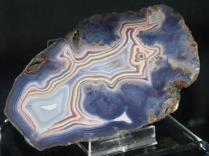
| Species: | Quartz var: Agate |
| Confirmation |
|---|
|
| Validity: | Believed Valid |
| Associated Minerals Based on Photo Data: |
|---|
|
| Prasiolite | ⓘ2 photos of Agate associated with Prasiolite at this locality. |
| Calcite | ⓘ2 photos of Agate associated with Calcite at this locality. |
| Data |
|---|
|
| Mineral Data: | Click here to view Agate data |
| Locality Data: | Click here to view Płóczki Górne agate field, Płóczki Górne, Gmina Lwówek Śląski, Lwówek Śląski County, Lower Silesian Voivodeship, Poland |
| Photo Gallery | View Gallery (16 photos) |
| Data Identifiers |
|---|
|
| Mindat Occurrence Record ID: | 646669 |
| Long-form Identifier: | 1:3:646669:5 |
| GUID (UUID V4): | 0179a143-ace4-496d-bced-60a42c2e20a6 |
| Nearest other occurrences of Agate |
|---|
|
|
| 1.2km (0.8 miles) | ⓘMogiła Hill, Płóczki Górne, Gmina Lwówek Śląski, Lwówek Śląski County, Lower Silesian Voivodeship, Poland |
| 1.7km (1.0 miles) | ⓘWywóz Hill, Pławna Dolna, Gmina Lubomierz, Lwówek Śląski County, Lower Silesian Voivodeship, Poland |
| 9.4km (5.8 miles) | ⓘPrzeździedza quarry, Przeździedza, Gmina Wleń, Lwówek Śląski County, Lower Silesian Voivodeship, Poland |
| 10.7km (6.7 miles) | ⓘMelafirowa Skała, Wleń, Gmina Wleń, Lwówek Śląski County, Lower Silesian Voivodeship, Poland |
| 10.8km (6.7 miles) | ⓘUnnamed quarry, Wleń, Gmina Wleń, Lwówek Śląski County, Lower Silesian Voivodeship, Poland |
| 21.4km (13.3 miles) | ⓘDynowice, Nowy Kościół, Gmina Świerzawa, Złotoryja County, Lower Silesian Voivodeship, Poland |
| 21.5km (13.4 miles) | ⓘLubiechowa quarry, Lubiechowa, Gmina Świerzawa, Złotoryja County, Lower Silesian Voivodeship, Poland |
| 22.1km (13.7 miles) | ⓘRailway cut, Nowy Kościół, Gmina Świerzawa, Złotoryja County, Lower Silesian Voivodeship, Poland |
| 22.2km (13.8 miles) | ⓘRóżana (Wołek; Kotek Hill), Nowy Kościół, Gmina Świerzawa, Złotoryja County, Lower Silesian Voivodeship, Poland |
| 32.0km (19.9 miles) | ⓘJizerská louka, Jizerka, Kořenov, Jablonec nad Nisou District, Liberec Region, Czech Republic |
| References |
|---|
|
|


Płóczki Górne agate field, Płóczki Górne, Gmina Lwówek Śląski, Lwówek Śląski County, Lower Silesian Voivodeship, Poland