 | | Report (issue) | | Quadrangle, Colorado GEOLOGICAL SURVEY PROFESSIONAL Prepared in cooperation with the Colorado State Geological...Geological Survey Board and the Colorado Metal Mining Fund PAPER 289 Geology and Ore Deposits of...of the Garfield Quadrangle, Colorado By McCLELLAND G. DINGS and CHARLES S. ROBINSON GEOLOGICAL SURVEY...in cooperation with the Colorado State Geological Survey Board and the Colorado Metal Mitting Fund. A...________________ _ Quartz-mica schist _____________ _ Quartz-hornblende schist _______ _ Quartz-hornblende gneiss | 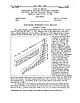 | | Journal (issue) | | - - - - - - - ' - - - - - - - - - - - - , . the mining and metallurgical industries in the State rose...wage earners who are employed full time in the mining and metallurgi cal industries, since firms with...total reported in Table 1. Not all segments of the mining and metallurgical industry showed gains during...May wi th the closing of the stockpile, and * Mining Engineer, State of Oregon Department of Geology...gives the value of the minerals produced in each county and lists the minerals in order of their importance |  | | Report (issue) | | for illustrations of stone artefacts from Alfred County Cave, Justin Morris and Mick Lindop. In addition...such as grindstones, large hammerstones used in mining operations, or figurines (as from Zimbabwe), associated...Stone Age industrial traditions (Sampson 1974; J. Deacon 1984b). To some extent the discreteness of some...highlands of Namibia respectively (H. J. Deacon & J. Deacon 1980); but see also and thence south through...Zambezi have diverged, a divergence that some (H. J. Deacon & Thackeray 1984) have invoked as contributing |  | | Journal (issue) | | July 1, 1972, and which will require a permit, a mining plan, a reclamation program and the payment of...and millions of dollars more are being spent by *Mining Engineer, Oregon Department of Geology and Mineral...Metals The mining and smelting of nickel ore at the Hanna operation at Riddle in Douglas County continued...continued to be the state's most important metal mining activity. Utilization of some of the vast pile of slag...The old Maury mine east of Prineville in Crook County was explored with the aid of an OME loan by C. |  | | Journal (issue) | | foreset bedding in the rubbly gravel (Schlicker and Deacon, 1967, p. 32-35) and by channels in previous sand...12 S •• R. 2 W., south of Peterson Butte. Linn County . other eJ'l"atics an nearby. FiguN The effect...University Press, p. 231242. Schlicker, H.G., and Deacon, R.J., 1967, Engineering geology of the Tualatin...PUBLIC HEARING Notice is hereby given that Coos County intends to lease mineral rights for gas and oil...oil in approximately 13,000 acres of land in Coos County. Descriptions will be sent on request to below |  | | Journal (issue) | | Cover photo The Tualatin Valley in Washington County, as seen on an old plastic relief map. Vertical...landslides Paleontology 42 42 38 32 Stratigraphy Mining history 31 When asked about including new topics...INTRODUCTION The Tualatin basin, located in Washington County, is a northwest-southeast trending elliptical structure...Tualatin basin (Hart and Newcomb, 1965; Schlicker and Deacon, 1967). As much as 300 m of the middle Miocene...Tualatin Valley (Hart and Newcomb, 1965; Schlicker and Deacon, 1967) as well as the Paleogene history of the |  | | Journal (issue) | | most wide-spread species, being common in both Colorado and Mojave desert areas and Arizona. A low plant...Stones Found in Veins of Coal By CHARLES KELLY MINING Gold That Came from Goldfield By JOHN HILTON 8...Rubber Plant of the Desert By HOWARD KEGLEY 29 MINING Briefs from the desert 32 September temperatures...Last year, however, I moved to Fruita, in Wayne county, where I became intimately acquainted with Dr...workings in that area. As county engineer in one of the most famous gold mining districts in the world, |  | | Journal (issue) | | Apple Valley, California. September 3-5—Socorro County Rodeo, Socorro, New Mexico. Volume 18 September...Lancaster, California. September 8-11 — Coconino County Fair, Flagstaff, Arizona. September 9-11—Navajo...Roswell, New Mexico. September 14-18 — Yavapai County Fair, Prescott, Arizona. September 15-16—Mexican... Scottsdale, Arizona. September 23-24 — Apache County Fair, St. Johns, Arizona. September 24-25 — Barstow...e Desert . . . URANIUM Progress of the mining b o o m MINING Current n e w s of desert m i n e s LAPIDARY |  | | Journal (issue) | | 97201 The ORE BIN Volume 36, No.1 0 October 1974 MINING LAW STILL INTACT, BUT PROSPECTORS FACE NEW SET...amended mining laws of 1872. These regulations became effective September 1, 1974. Although the Mining Law...within the boundaries of the National Forests. The Mining Law of 1872 generally gives the prospector and...Forest Service, Portland, Oregon 97208, or from any District Ranger Station. 1. What is the purpose of the...development, mining and processing operations carried out under the authority of the U.S. mining laws of 1872 |  | | Journal (issue) | | ) on the west slope of the Tualatin Mountains. Quartz and feldspar constitute 35 and 36 percent, respectively...Trimble, 1963; Livingston, 1966; Schlicker and Deacon, 1967) and (3) a combination of fluvial and eolian...and Deacon, 1967), the Troutdale-equivalent sediments of the Tualatin Valley (Schlicker and Deacon, 1967)...However, subsurface data reported by Schlicker and Deacon (1967) indicate that both the Tualatin Valley sediments...nine Portland Hills Silt samples. Average Percent Quartz 40.6 Chert 0.9 Alkali feldspar 18.3 Plagioclase |  | | Journal (article/letter/editorial) | | estimating premining water quality: Red Mountain Creek, Colorado Robert L. Runkel a c a,* , Briant A. Kimball...CO 80225, USA b US Geological Survey, 2329 W Orton Circle, West Valley, UT 84119-2047, USA US Geological...Stop 673, Denver Federal Center, Denver, CO 80225, USA Received 26 June 2006; accepted 20 March 2007 Editorial...watersheds with past mining activity. Baseline water quality data obtained prior to mining are often non-existent...given the geology of most watersheds affected by mining. Various approaches have been used to estimate |  | | Journal (volume) | | Stratigraphy and History of the Blue River drainage, Lane County, Oregon: A stratigraphic study of glaciolacustrine...Springs Zone of Contribution, Crystal Springs Water District, Odell, Oregon . . . . . . . . . . . . . . .15...Stratigraphy and History of the Blue River drainage, Lane County, Oregon: A stratigraphic study of glaciolacustrine...glacial history of the Blue River drainage, Lane County, Oregon (Figure 1). Previous geomorphic and geologic...Columnar Section along Blue River drainage, Lane County, Oregon. Regional Setting The Western Cascade |  | | Journal (issue) | | cooperation with other state agencies and with county and local planning commissions to carry out environmental...their productive efforts during the year. Both mining and metallurgy are productive only in response...million, down 2.4 percent from the previous year. * Mining Engineer, State of Oregon Dept. Geology & Mineral...the year. In the River750 750 Gem stones gate district of Portland, Gold (recoverable content Oregon...Salem Hills district of Marion County. The Lower Powder River and Sparta districts of Baker County were the |  | | Report (issue) | | resources of the Soda Mountain Wilderness Area, Jackson County, Oregon. [Menlo Park, CA] : U.S. Geological Survey...East Cactus Plain Wilderness Study Areas, La Paz County, Arizona. [Menlo Park, Calif.] : U.S. Geological...the Diablo Mountain Wilderness Study Area, Lake County, Oregon. [Menlo Park, CA] : U.S. Geological Survey...Creek and Sperry Creek Wilderness Areas, Malheur County, Oregon. [Menlo Park, CA] : U.S. Geological Survey...Wilderness Study Area, White Pine County, Nevada, and Millard County, Utah. [Menlo Park, Calif.] : U.S |  | | Journal (issue) | | sharp upward turn during the year as more and more county and city governments requested assistance from...expans i b1e s ha 1e quarry and plant in Washington County was assumed by GAT X Leasing Corporation. The plant...operation in Christmas Valley in northern Lake County. Table 1. Minerals Clays Gem stones Lime Nickel...1976. Considerable interest was directed to old mining districts having a history of gold, silver, or...copper mine on the Snake River in eastern Baker County was explored by Texasgulf. The Iron Dyke has a |  | | Journal (issue) | | surface only during periods of excessive runoff, mining and prospecting operations have been generally...months. Geology The bed rock qf the Quartzville mining district is composed primarily of basalt, andesite,...used in describing distinguishable units in the district. The lowest unit exposed in and near the abandoned...units and are basaltic in composition. Within this district are areas of propy1itic alteration surrounding...fissures and faults (Munts, 1976). Mining History The Quartzvil1e mining district has been the site of both hard-rock |  | | Journal (issue) | | 40 surges of the Columbia River. Schlicker and Deacon (1967, p. 29-35) described the Wi11amette Silt...has remnant ridges, such as those in the Alameda district of northeast Portland and in the St. Johns area...summit elevation of about 240 ft (Schlicker and Deacon, 1967. p. 30-32). These sands, which form uneven...a few feet to about 50 ft thick (Sch licker and Deacon, 1967, p. 30-32). FiguN 7. Fine - grained fluvial...northern facies . The silt cons i sts mainly of quartz , feldspar, and mi ca, but a great variety of other |  | Bergquist, J.R., King, H.D., Blakely, R.J., Sawatzky, D.L., Olson, J.E. (1990) Mineral resources of the Badlands Wilderness Study Area and the Badlands Wilderness Study Area Additions, Crook and Deschutes counties, Oregon. Open-File Report Vol. 1990 (90-511) US Geological Survey doi:10.3133/ofr90511 | Report (issue) | | mineralized areas by collecting data on current and past mining activities and through field examination of mines...eastern part of Deschutes County and approximately one-fourth is in western Crook County. Relief in the study...resource potential of slab lava throughout Deschutes County (including the Badlands area), and Olson (1987...collection of information related to current and past mining activity in the region. A library search was made...Land Management mining claim recordation indices, the Crook and Deschutes Counties mining claim records |  | | Journal (issue) | | geologic hazards study of northwestern Clackamas County now available The Oregon Department of Geology...and Geologic Hazards of NorlhweSlern Clackamas County, Oregon, published as Bulletin 99. The study was...Conservation and Development Comm ission, and Clackamas County. Au thors of the report are Herbert G. Sch licker...northwestern Clackamas County. _. GEOLOGY AND GEOLOGIC HAZARDS OF NORTHWESTERN CLACKAMAS COUNTY. OREGON ...-...valley, Golden and Silver Falls State Park, Coos County. Here stream nows over rocks of the Flournoy Formation |  | | Book (edition) | | ••••..•••. •· • • • • •• •··· · · · • · ••• ·• Colorado .................................................................................. •• • • • • Colorado .................................................... Colorado ........................................................... . . . . . . Quartz ................. Colorado............................................................ Rose quartz ............................................ Tounnalinated quartz .............................................. |  | | Journal (issue) | | Existence of the tubes was first noted by R. J. Deacon (Shannon and Wilson, Inc., 1968) during a foundation...south of the centra I depression (Schlicker and Deacon, 1967, pl. 2, C-C'). The lava overlies 434 feet...debris of the collapsed roofs. According to R. J. Deacon (Shannon & Wilson, 1968), the "rubble-filled channels"...with locations keyed to index on reverse, showing county listings, maximum temperatures, references 1.00...77, p. 183-206, 24 figs. Sch Ii cker, H. G., and Deacon, R. J., 1967, Engineeri ng geo logy of the Tualatin |  | | Journal (issue) | | February 20, 1984, Reichhold Energy spudded Columbia County 43-22 in sec. 22, T. 6 N., R. 5 W. The well, an...an offset to the recently completed Columbia County 23-22, was drilled and completed to production on...proposal by Reichhold Energy to drill Columbia County 13-34A in the Mist Gas Field. The proposed well...009-00126 SEl4 sec. 28 T. 6N., R. 4 W. Columbia County Application; 2,500. 259 Hutchins & Marrs Great...2 019-00023 NW',4 sec. 20 T.30S.,R.9W. Douglas County Application; 3,500. 0 Grants Pass Field Office: |  | | Report (issue) | | Eclipse and Van Ness Placer Tucker Gulch Placers Quartz Creek Placer Mines Tami Lynn 1-4 Placers High Channel...Eileen Marcia Placer Mine DC08414 Marrion Creek Gold Mining D004077 Company Placer Bluff Creek Copper Claim...Claim W026617 Eureka Prospect W026618 St. Joe Quartz Prospect W026619 Lintz and Stafford Prospect D004188...Creek Placer Frances Copper Prospect Glen Metals Mining Co. Mine Iron Mask Mine New Lenore Group Goldbug...Aladdin Mine Mayflower Claim Revenge Prospect Darby Mining and Milling Co. Copper Queen Pay Rock Mine Drake |  | | Report (volume) | | Mines and Mining Research. Center for Geological and Mining Research]. Paris, France. Colorado State Univ...Univ. Agr. Expt. Sta. Gen. Ser.-Colorado State University Agricultural Experiment Station General Series...and Geology Bull. Idaho Bur. Mines and Geology County Rept.Idaho Bur. Mines and Geology Mineral Resources...Idaho Bureau of Mines and Geology Bulletin and County Report and Mineral Resources Report. Moscow, Idaho...Department of Geology and Mining, Madhya Pradesh. Raipur, India. Mining Geology-Mining Geology. Journal of |  | | Report (issue) | | Price 32 Technology Underground mining Open-pit mining Alluvial mining Processing Secondary recovery Refining...Location of gold and occurrences and former gold mining sites in the United Kingdom Fig 2a Price of gold...relatively small in the United Kingdom compared with the USA, Japan and West Germany, being about 30 tonnes in...occurs in a vein. A reef is a lode of auriferous quartz. Alluvial or placer gold occurs in alluvial gravels...tree in the auriferous region of Guyana, but in Colorado the ash of wood from the interior of large roots |
|


