Chott el Djerid, Tunisiai
| Regional Level Types | |
|---|---|
| Chott el Djerid | Saline Lake |
| Tunisia | Country |
This page is currently not sponsored. Click here to sponsor this page.


Neighbouring regions:
Type:
Mindat Locality ID:
253051
Long-form identifier:
mindat:1:2:253051:5
GUID (UUID V4):
18690b68-bb60-4169-af60-907c70193a46
Other Languages:
Arabic:
شط الجريد, تونس
French:
Chott el-Jérid, Tunisie
German:
Chott el Djerid, Tunesien
Italian:
Chott el-Jerid, Tunisia
Russian:
Эль-Джерид, Тунис
Simplified Chinese:
杰里德大盐湖, 突尼西亞
Spanish:
Chott el Djerid, Túnez
Afrikaans:
Chott el Jerid, Tunisië
Azeri:
Əl Dicerid
Basque:
Chott el Djerid
Belarusian:
Шот-эль-Джэрыд, Туніс
Bulgarian:
Шот ел-Джерид, Тунис
Catalan:
Chott El Djerid, Tunísia
Chuvash:
Шотт-эль-Джерид
Czech:
šot al-Džaríd, Tunisko
Dutch:
Sjott el-Djerid, Tunesië
Esperanto:
Ŝot el Ĝerid
Finnish:
Chott el Djerid, Tunisia
Georgian:
შოტ-ელ-ჯერიდი
Japanese:
ジェリド湖, チュニジア
Korean:
엘제리드호, 튀니지
Lithuanian:
Džeridas, Tunisas
Polish:
Wielki Szott, Tunezja
Portuguese:
Chott el Jerid, Tunísia
Serbo-Croatian:
Šot al-Džaríd
Slovenian:
Chott el Djerid, Tunizija
Swedish:
Chott el Djerid, Tunisien
Traditional Chinese:
傑里德大鹽湖
Ukrainian:
Шотт-ель-Джерід, Туніс
Welsh:
Chott el-Jerid, Tunisia
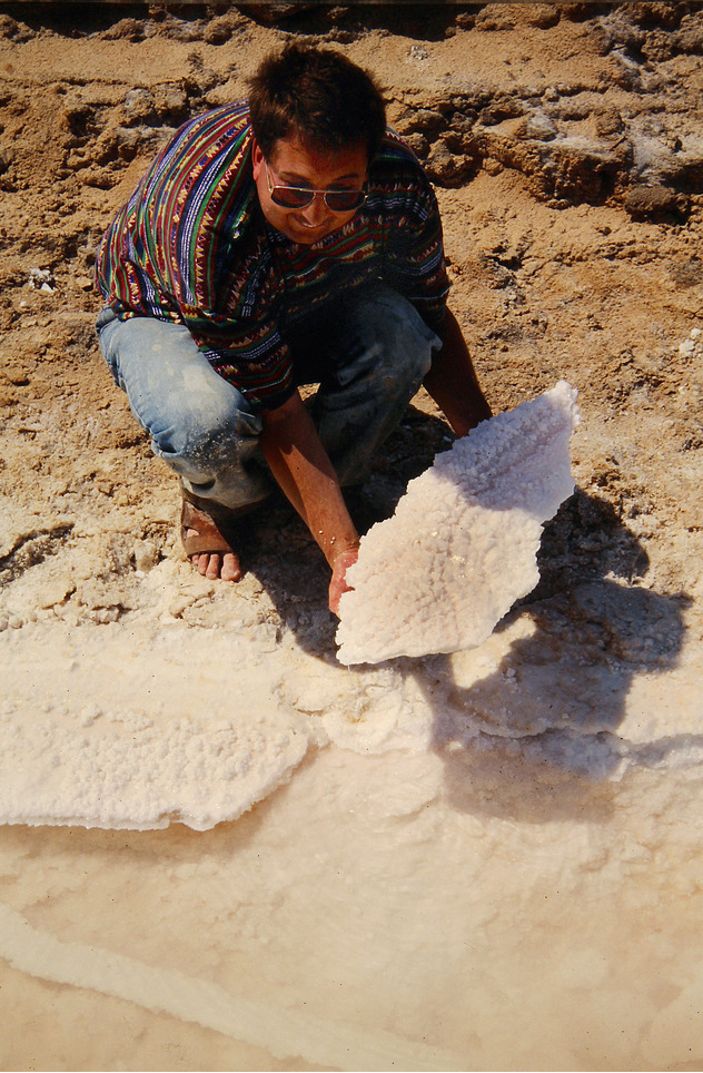
Chott el Djerid (Arabic: شط الجريد Šoṭṭ el-Jarīd) also spelled Sciott Gerid and Shott el Jerid, is a large endorheic salt lake in southern Tunisia. The name can be translated from Arabic into English as "Lagoon of the Land of Palms".
The bottom of Chott el Djerid is located between 10 and 25 meters (about 30 to 80 feet) below sea level. The lake's width varies widely; at its narrowest point, it is only 20 km (12 mi) across, compared to its overall length of 250 km (160 mi). At times, parts of it appear in various shades of white, green and purple. The narrow eastward inlet of the chott is also known as Chott el Fejej.
It is the largest salt pan of the Sahara Desert, with a surface area of over 7,000 km² (some sources state 5,000 km²). The site has a typical hot desert climate. Due to the harsh climate with a mean annual rainfall of below 100 mm and daytime temperatures sometimes reaching 50 °C (122 °F) or more during summer with dense solar radiation, water evaporates from the lake. In summer Chott el Djerid is almost entirely dried up, and numerous fata morganas occur. Situated at 33 ° 42'N 8 ° 26'E in the centre-west of the country, between the cities of Tozeur and Kebili.
During winter, a small tributary of water can be seen discharging into the lake.
Because the flooded area is very variable, values presented for the area of the lake (or its basin, which is almost always dry), can vary widely. Some sources provide values as high as 10,000 km². Similarly, figures given for altitude vary between 10 meters above and 25 meters below sea level.
Currently, freshwater irrigation schemes are being applied in the region to help eliminate salt from soils and increase the productive area.
South of Chott el Djerid, the Grand Erg Oriental desert begins. The towns of Kebili and Douz are also located south of the lake.
The lake can be crossed by foot and even by car, but this is very dangerous since the salt crust is not always firm.
During winter, when the lake is full, it can be crossed by boat. Piles of salt at its edges are collected for salt production processing.
Select Mineral List Type
Standard Detailed Gallery Strunz Chemical ElementsGallery:
Fossils
This region is too big or complex to display the fossil list, try looking at smaller subregions.Other Databases
| Wikipedia: | https://en.wikipedia.org/wiki/Chott_el_Djerid |
|---|---|
| Wikidata ID: | Q849143 |
| GeoNames ID: | 2470175 |
This page contains all mineral locality references listed on mindat.org. This does not claim to be a complete list. If you know of more minerals from this site, please register so you can add to our database. This locality information is for reference purposes only. You should never attempt to
visit any sites listed in mindat.org without first ensuring that you have the permission of the land and/or mineral rights holders
for access and that you are aware of all safety precautions necessary.


Chott el Djerid, Tunisia