 | | Journal (article/letter/editorial) | | the --------Arkansas Magnet Cove locality. - - - - - - - - Minerals of the Wilson Springs Vanadium Mines...Mines POTASH SULPHUR SPRINGS, ARKANSAS J. MICHAEL HOWARD Arkansas Geological Commission 3815 West Roosevelt...Little Rock, Arkansas 72204 DON R. OWENS Earth Science Department University of Arkansas at Little Rock...Rock 2801 South University Little Rock, Arkansas 72204 Unless otherwise noted, all photos by J. Michael...Owens collection 154 ROCKS & MINERALS Sulphur Springs was taken by William H. Lewis in 1844. By 1855 |  | | Journal (article/letter/editorial) | | maps on Google seemed to average twelve states (North Dakota, South Dakota, Nebraska, Kansas, Minnesota...states at its 2017 February show (add Oklahoma, Arkansas, Kentucky, and Tennessee); hence, they will all...states— Michigan, Wisconsin, South Dakota, and Arkansas—at the periphery of the area tally over three...completely overlap. It is clear that their source springs from many more rock types than just sedimentary...phosphate species being described from just one mine, the Tip Top, in South Dakota. (Note: There are |  | | Book | | Collecting Arkansas JVlinerals A Reference and Guide By Arthur E. Smith, Jr. ,'T Collecting Arkansas...Box 2043 Coeur d’Alene, Idaho 83816-2043 iii Arkansas Counties 1 \ I •( 11 o •« c »««ou cxi ju4«iO«J...573-308-3500 703-648-6045 or phone 800-USA-MAPS Map 3. Arkansas’ Ouachita Mountains 7.5 Minute Quadrangal...Quadrangal Map index. V Contents and Locality Index Arkansas Quartz Crystal Deposits Special Quartz Types....Location 1 Montgomery County quartz deposits................. Other Montgomery County quartz mines...... |  | | Journal (issue) | | werner@lcturbonet.com In the Green River Basir of Sweetwater County, Wyoming, lies the world's largest,known deposit...supplied by volcanic ash ·and andesitic tuff from the north and was leached from the detrit:l!l.m~terii,iltranspo~~d-foto·the...say it is only known from 3 ·i are~: Garland County in Arkansas, Cornwall in the United Kingdom, and·the...they were visiting the North Wilson pit, a vanadium mine near Wilson· Springs (also type locality for...for miserite and straczekite; in Garland County, Arkansas). Buford Nichols had brought along his field |
|


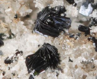


North Wilson pit, Union Carbide Mine, Wilson Springs, Garland County, Arkansas, USA