| Locality type: | Area |
| Classification |
|---|
|
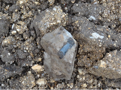
| Species: | 'Tourmaline' (not an IMA approved species) |
| Formula: | AD3G6 (T6O18)(BO3)3X3Z |
| Confirmation |
|---|
|
| Validity: | Confirmed |
| Confirmation Methods: | Visually Identified |
| Data |
|---|
|
| Mineral Data: | Click here to view Tourmaline data |
| Locality Data: | Click here to view Goldberg-Dürrloh area, Selb, Wunsiedel im Fichtelgebirge, Upper Franconia, Bavaria, Germany |
| Photo Gallery | View Gallery (7 photos) |
| Data Identifiers |
|---|
|
| Mindat Occurrence Record ID: | 1034901 |
| Long-form Identifier: | 1:3:1034901:4 |
| GUID (UUID V4): | 3f0e8917-588e-457b-a517-0f82eef2db04 |
| Nearest other occurrences of Tourmaline |
|---|
|
|
| 11.6km (7.2 miles) | ⓘJohannes Mine, Göpfersgrün, Wunsiedel, Wunsiedel im Fichtelgebirge, Upper Franconia, Bavaria, Germany |
| 19.4km (12.0 miles) | ⓘReinersreuth quarry (Köhlerloh quarry), Reinersreuth, Sparneck, Hof District, Upper Franconia, Bavaria, Germany |
| 19.6km (12.2 miles) | ⓘAcherwiese, Schönbrunn, Wunsiedel, Wunsiedel im Fichtelgebirge, Upper Franconia, Bavaria, Germany |
| 19.7km (12.2 miles) | ⓘUranium deposit, Rudolfstein, Weißenstadt, Wunsiedel im Fichtelgebirge, Upper Franconia, Bavaria, Germany |
| 21.9km (13.6 miles) | ⓘFuchsbau quarry, Tröstauer Forst-West, Wunsiedel im Fichtelgebirge, Upper Franconia, Bavaria, Germany |
| 22.3km (13.8 miles) | ⓘZufurt quarry, Tröstauer Forst-West, Wunsiedel im Fichtelgebirge, Upper Franconia, Bavaria, Germany |
| 25.8km (16.0 miles) | ⓘWolfskehle quarry, Nagel, Wunsiedel im Fichtelgebirge, Upper Franconia, Bavaria, Germany |
| 27.1km (16.8 miles) | ⓘBasalt works, Triebendorf, Wiesau, Tirschenreuth District, Upper Palatinate, Bavaria, Germany |
| 27.3km (16.9 miles) | ⓘBayerland mine, Pfaffenreuth, Leonberg, Tirschenreuth District, Upper Palatinate, Bavaria, Germany |
| 33.9km (21.1 miles) | ⓘSaubachriss, Muldenberg, Grünbach, Falkenstein, Vogtlandkreis, Saxony, Germany |
| References |
|---|
|
|


Goldberg-Dürrloh area, Selb, Wunsiedel im Fichtelgebirge, Upper Franconia, Bavaria, Germany