 | | Journal (article/letter/editorial) | | sites. ZEOLITES of Washington State Tertiary-age volcanics cover much of Washington State, but only portions...portions of that huge expanse of rock contain zeo lites. The Miocene Columbia River plateau, which makes...surface of the Columbia River Basalt of eastern Washington is the type locality for paulingite at RUDY...TSCHERNICH 526 A v e n u e A S n o h o m i s h , Washington 98290-2414 T H E VOLCANICS IN T H E PACIFIC...collecting is con centrated in fresh exposures of rock in quarries, highway and dam construction sites |  | | Journal (article/letter/editorial) | | that occur in beautiful specimens in Washington. minerals Washington Mineral Locality Index L A N N Y R...okanoganite-(Y), and zektzerite, all from Washington Pass in Okanogan County —which are known only from the state;...in Snohomish County, ferritungstite from Germania mine near Fruitland in Stevens County, and paulingite...paulingite from Rock Island Dam near Wenat chee in Douglas County. In addition, many localities pro duce fine-quality...preparing the alphabet ical list of localities. Chelan County Crown Point mine, near Holden; M O L Y B D E N |  | | Journal (issue) | | fradint; ot opec-.o, lDcatiooo, tall tales ( a - the rock that got &11117). -. •• * !here v1ll be a proJector...Rudy W. Tschernich 526 Av•. A, I A Snohomish, Washington 98290 206-568-2857 0~ 568-5369 ZEOLITE COLLECTING...Russell Boggs at Eastern Washington University. HISTORY: Goble, in Columbia County, Oregon is one of the...Acio::::ular zeol i t.P.s 1 ike me-sol; t• •nd mordenite were noticeably absent. With widening of the highway...and cut off the old access road that led up Goble Creek. Construction of a new access road (now called the |  | | Book | | Bart Cannon 1975 CORD ILLERAN Mercer Island, Washington Lilli liliiiLt' 111? KLi-KlLLLIlrVlIlI Copyright...Cordilleran 18 Holly Hill Drive Mercer Island, Washington 98040 COVER ILLUSTRATION: Amethyst scepter heads...milky quartz stems. Denny Mountain area of King County. Specimen from the collection of Cary A. Maykut...publications dealing with the various aspects of Washington State's diverse mineral wealth exist, but none..."Minerals of Washington" represents an attempt to begin such a cata logue. "Minerals of Washington" shall |  | | Book | | levyne, mazzite, merlinoite, montesommaite, mordenite, offretite, paulingite, perlialite, thomsonite...analcime, bikitaite, edingtonite, ferrierite, mordenite, natrolite, thomsonite, tschernichite, and wairakite...GMELINITE LEVYNE EPISTILBITE FAUJASlTE POLLUClTE MORDENITE OFFRETITE GONNARDITE WELLSlTE* ERIONITE DACHIARDITE...the rock, changes composition, precipitates zeolites and other minerals, and flows out of the rock unit...where it flows out of the system. . . . . mordenite are of major importance, with minor phillipsite | | | Book | | levyne, mazzite, merlinoite, montesommaite, mordenite, offretite, paulingite, perlialite, thomsonite...analcime, bikitaite, edingtonite, ferrierite, mordenite, natrolite, thomsonite, tschernichite, and wairakite...GMELINITE LEVYNE EPISTILBITE FAUJASlTE POLLUClTE MORDENITE OFFRETITE GONNARDITE WELLSlTE* ERIONITE DACHIARDITE...the rock, changes composition, precipitates zeolites and other minerals, and flows out of the rock unit...where it flows out of the system. . . . . mordenite are of major importance, with minor phillipsite |  | | Report (issue) | | years, zeolites have been recognized as important rock-forming constituents in low-grade metamorphic rocks...the following: formation name and age of the host rock, lithology (includes tuff, sandstone, shale or mudstone...and M. Aoki (1975). "Hydrothermal alteration of mordenite rocks in sodium carbonate solution with reference...analcimization. analcimizat Hydrothermal studies on the wall-rock alteration." Ganseki Kobutsu Kosho Gakkaishi 68(5):...chemical behavior. III. Hydrothermal studies on wall-rock alteration." Ganseki Kobutsu Kosho Gakkaishi 68(9): | 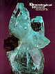 | | Journal (issue) | | . and Peter Keller, curator at the Los Angeles County Museum of Natural History, were instrumental in...unparalleled beauties of the mineral kingdom. In the hard rock were numerous and widely diversified crystallizations...DyrafjorSur 6. Tindastoll and SkagafjorSur Mountains 6. Rock walls in front of Akureyri 7. Djupivogur in eastern...different from that in olivine basalts. Chalcedony, mordenite, chlorophaeite, celadonite and epistilbite are...tholeiites. Above this is a zone consisting largely of mordenite accompanied by chalcedony and quartz rather errati |  | | Journal (article/letter/editorial) | | of volcanic rock-hosted uranium deposits in northwestern Nevada and southeastern Oregon, USA Stephen B...School of Mines, Mail Stop 178, Reno, NV 89557, USA Received 14 June 1999; accepted 24 September 1999...occurs as hydrothermal uraniferous zircon, and whole rock samples contain as much as 5% Zr. Gangue minerals...host rocks, hydrothermal activity unrelated to host rock volcanism, and deposition from ground water. With...radioactivity against that measured on unmineralized rock in the surrounding area. U analytical concentrations |  | | Journal (article/letter/editorial) | | established Montana’s first mining camp at Gold Creek in 1860. Geologic Provinces The state can be divided...Indian Queen mine ca. 1905 at Farlin, Beaverhead County. 208 ROCKS & MINERALS Downloaded by [University...mines at Butte in Silver Bow County and the Black Pine mine in Granite County have produced many fine crystal...Beaverhead County, the pegmatites of Jefferson County, and the Snowbird mine in Mineral County continue...Highlands Centennial Nugget in 1989 in Silver Bow County. The seventh largest gold nugget found in Montana; |  | | Report (issue) | | . . . . . . . . . . . . . . . . . . . . . . 1 County Listings. . . . . . . . . . . . . . . . . . . .... . . . . . . . 4 Mineral Localities Listed by County . . . . . . . . . . . . . . . . . . . . . . . .... . . . . . . . . . . . . . . . . . . 7 Beaver County . . . . . . . . . . . . . . . . . . . . . . . ... . . . . . . . . . . . . . . . . . 7 Box Elder County . . . . . . . . . . . . . . . . . . . . . . . .... . . . . . . . . . . . . . . . . . . 10 Cache County . . . . . . . . . . . . . . . . . . . . . . . |  | | Report (issue) | | Johnson, Chair Baker City Ronald K. Culbertson Myrtle Creek Donald A. Haagensen Portland STATE GEOLOGIST Donald...2 1st 1985 Tucson. Arizona 22nd 1986 Linle Rock. Arkansas 23rd 1987 24th 1988 Greenville. South...Industrial minerals in Washington-1988: Production and potential Nancy L. Joseph, Washington Division of Geology...Geologists Foundation. Inc. The support of the Washington Division of Geology and Earth Resources during...from industrial minerals. Sand, gravel, and crushed rock accounted for approximately $1 15 m illion. Limestone |  | | Journal (article/letter/editorial) | | topaz, and other minerals. Unfortunately, the host rock, a pink granite, lies within a Wilderness Area in...across, on blue thomsonite. Lucky Peak Dam, Ada County; Lanny Ream specimen and photo. Figure 3 (below)...cut near Pinehurst, Adams County; Lanny Ream specimen and photo. Ada County Lucky Peak Dam, on east side...CHABAZITE, LEVYNE, PHILLIPSITE, and THOMSONITE. Adams County Alaska mine, Seven Devils district: azurite, grossular...replacing molybdenite and scheelite. Little Goose Creek Canyon, 5 miles east of New Meadows, placer deposits: |  | | Journal (issue) | | Columbia County Permit denied; spacing unit violation. 352 ARCO SEV4 sec. 27 Columbia County 44-27 T...009-00191 Columbia County Location; 2,360. NEV4 sec. 4 T.5 N.,R. 5 W. Columbia County SEI/4 sec. 6 354...354 ARCO Columbia County 44-6 T. 6 N., R. 5 W. 009-00193 Columbia County Application; 3,000. 353 ARCO...sec. 7 355 ARCO Columbia County 31- 7 T. 6 N., R. 5 W. 009-00194 Columbia County Application; 3,000. SWI/4... 21 356 ARCO Columbia County 13-21 T. 6 N., R. 5 W. 009-00195 Columbia County Application; 3,000. D |  | | Book | | PUBLISHED BY Western Mineral Exchange Seattle, Washington 1941 t Copyright 1941 WESTERN MINERAL EXCHANGE...Co. Hematite CALERA, Shelby Co. Wavkllite CLAY COUNTY, Sec. 24. T. 19 S R., 7 E. STATUARY, Coosa Co...Co., (W. border of* Marble Crystalline TALLADEGA COUNTY Marble, (crystalline) VALLEY HEAD, DeKalb Co. Hematite...Feldspar HISSOP, Coosa Co., (near) Beryl JACKSON COUNTY Hematite KENNEDYS, Clay Co., (near) Magnetite MILLERVILLE...Magnetite PRATT FERRY, Bibb Co., (near) Verigated Marble ROCK RUN to JACKSONVILLE, Calhoun Co. Bauxite ROCKFORD |  | | Book (edition) | | 310 Z . Zinnwald ite - Zoisile / 3 11 Appendix I County Index / 3 17 Appendix n Bibliography / 323 Part... l 1 Coeur d 'Alene Mining District Sh oshone County His tory The world's largest silver-producing mining...District, Wardner District, Kellogg District, Pine Creek District, and more. These names are primarily long...miles wide and 25 miles long, ext ending from Pine Creek, a few miles west of Kellogg, east to the IdahoMontana...mines, are located. Other faults include the Placer Creek and Cate faults and an apparent undefined fault |  | | Book (volume) | | org/details/rockformingminerOOOOdeer \ ROCK-FORMING MINERALS ROCK-FORMING MINERALS Vol. 4 Framework Silicates...principle in this selection is implied in the title Rock-Forming Minerals, as, with a few exceptions, only...absence, serve to determine or modify the name of a rock. Some may quarrel with the inclusion or omission...partially solved problems are also mentioned. The rock-forming minerals are dealt with in five volumes...confused. The Paragenesis section gives the principal rock types in which the mineral occurs and some typical |  | | Journal (issue) | | with pyrite, 7 cm, from Spruce Ridge, King County, Washington; Rick Dillhoff collection; Jeff Scovil photo...left) Mesolite, 5.1 cm, from the F-Line quarry, Washington; John Cornish collection. Elbaite, 7 cm, from...Pacific Northwest; that is, the states of Oregon, Washington, Idaho, Alaska and the Canadian Provinces of...quartz specimens from Denny Mountain and King County, Washington, and the zeolites from the coastal basalts...642gram (52 troy-ounce) Turnagain Nugget, found on a creek in northern B.C. in 1937. The B.C. Department of |  | | Journal (volume) | | Mountain caldera, Ochoco National Forest, Crook County, Oregon 25 Field trip guide to the Oligocene Crooked...Crooked Basin and the ancestral Crooked River, Crook County, Oregon 73 Portland, Oregon, geology by tram, train...Baker City field office is relocating to the Baker County Court House. We have also moved the Nature of the...are the Oregon Lidar Consortium and the FEMA Coos County Multi-hazards Mapping Program. Both programs underscore...oregongeology.org Baker City Field Office: Baker County Courthouse, 1995 3rd Street, Baker City, Oregon |  | | Journal (issue) | | an kle-deep in water, miners drill holes in the rock at Taxco silver mine in Mexico. Right: North Sea...which are mined in large quantities from kimberlite rock. In addition, there are vast deposits of anrimony...(Germany); Chihuahua and Zacatecas (Mexico). In the USA, there are large quantities of acanthite at Leadville...Elongated, prismatic crystals of actinolite on a rock base (matrix) from Balzano, Italy. Below: Note the...in Siberia (Russia) and in Alaska and California, USA. The Alaskan deposits are found close to significant |  | | Report (issue) | | 31 University of Nevada Press, Reno, Nevada 89557 USA Copyright © 2004 by University of Nevada Press Photographs... Majuba Hill Mine, Antelope district, Pershing County. N. Prenn collection. Photograph by J. Scovil....Goodsprings (Yellow Pine) Mining District, Clark County John C. Kepper 91 References 467 Contributors...Humboldt County and the crystalline quartz collecting area on Petersen Mountain in Washoe County, permission...Wahmonie district in 1846, and it is probable that hard-rock metal mining by Mormon settlers beginning in 1855 |  | | Report (issue) | | MINERALS OF WASHINGTON, D.C. AND VICINITY by Lawrence R. Bernstein U. S. Geo^r^'ce.l Survey OPEN...^ Anne Arundel County 43 Baltimore County 45 Howard County - Montgomery County 88 Prince Georges...Georges County Virginia 74 . 120 129 Arlington County 129 Fairfax County 131 Fauquier County 139...139 Loudoun County 143 Prince William County 149 Diabase quarries of northern Virginia 155 CAPTIONS...localities of Washington, B.C., and vicinity. Plate 2. Generalized geologic map of Washington. D.C. and |  | | Book (volume) | | A Location Guide for Rock Hounds in the United States SOUTH DAKOTA This northwestern Great Plains state...beds, excavations, etc.Selenite roses. BRULE COUNTY AREA: in the Oacoma zone of the Pierre Fm. On Elm...gray Barite rosette up to 5 or 6 inches. CAMPBELL COUNTY MOUND CITY, W to the Missouri R., regional hillsides...gravels, etc.petrified wood, wood opal. CORSON COUNTY LITTLE EAGLE: area ridges, slopes, stream beds...438 A Location Guide for Rock Hounds in the United States CUSTER COUNTY AREA: The November Mine, 1 |  | | Report (issue) | | D.A . Moddle , E .W . Nuffield , Mrs . J .S. Stevenson and R . M. Thompson . It became apparent as the...llage ofActinolite in Elzevir Township, Hastings County . 31 F /1 5 Chemi cal analysis of a light greenish...actino l ite from Westmeath Township , Renfrew County: Si0 2 56 . 70 , Al 0 3 1. 62 , Fe o 3 . 06 , FeO...of tough greenish rock in the Township of St . Francis (Beauceville ) , Beauce County : Si0 52 . 30 , Al...nt as stout radiating fibres in the matrix of the rock. The soda amphibole, r iebeckite, is closely associated |  | | Report (volume) | | 985 UNITED STATES GOVERNMENT PRINTING OFFICE, WASHINGTON : 1952 UNITED STATES DEPARTMENT OF THE INTERIOR...of Documents, U. S. Government Printing Office Washington 25, D. C. - Price $1.00 (paper cover) CONTENTS...Photogeology _______________ Popular and elementary _______ Rock descriptions____________ Study and teaching______...geology. Articles written for the layman. Listed by rock names and areas. Articles dealing with the educational...Survey and of other surveys. Articles on the chemical rock-forming systems; listed alphabetically. Subheadings |
|


Rock Creek, Stevenson, Skamania County, Washington, USA