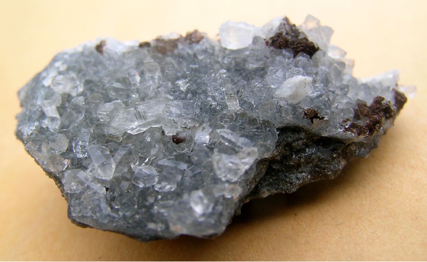
 | | Book | | V/C/N/TY ^^o Red beds MAP of fhe. /=zh NORFOLK SELL IS(^HAM ° HARVARD CONGLOMERATE andL SCI...I 5 iiJ DIORITE ANDOVER QUARTZ QU/NCY SHARON GRANITE SYEN/TE DIORiTE ^, ^^^...Department of Geology Boston University Boston, Massachusetts 02215 to; PREFACE In 1966, John Rodgers...Davis in the Connecticut Valley of western Massachusetts, and gradually extended itself. oo over New...Brown University The Foxboro Co., Foxborough, Massachusetts Geography, University of Toronto U. S. G, S |  | | Journal (article/letter/editorial) | | extends from southeast ern Connecticut across Massachusetts to just north of Cape A n n . Cutting across...s mond Granite and related rocks); alkaline, quartz-rich ig neous rocks (the largest is the Scituate...margin of the state extending eastwards into Massachusetts. I n general, as shown in Figure 1, western...named for the quartzite, chlorite-quartz schist, 0 i_ i ° K m quartz-mica schist, marble, and mafic...of southern and western Rhode Island, which are quartz-rich, recrystallized, and deformed rocks that are |  | | Report (issue) | | so-called Pennsylvanian basins of southeastern Massachusetts. Three papers deal with the geology of alkali...alkali plutonic-volcanic areas in Massachusetts and New Hampshire. High-grade and low-grade (prehnite-pumpellyite)...(prehnite-pumpellyite) metamorphism in Massachusetts and Maine, respectively, are the subjects of two of the papers...and the geology of the Ayer Granodiorite of Massachusetts. JOHN R,. GRIFELN STUDIES IN NEW ENGLAND...Brownlow V1 Vil iX Part I. Geology of eastern Massachusetts INaTOROVGNNE TON “5. B bo 8 OR Bo ee ek 5 ee |  | | Report (issue) | | reworked and segregated into texturally mature quartz sand by coastal processes that formed a segmented... The Narragansett basin is in southeastern Massachusetts and eastern Rhode Island and structurally is...coal-bearing Narragansett basin and the adjacent Norfolk basin, which does not contain minable coal, is...time, which first affected the northern region (Norfolk basin and northern Narragan- sett basin) where...1978, Coal and graphite mines and prospects of Massachusetts, Rhode Island, in Skehan, J. W., and Murray |  | | Journal (article/letter/editorial) | | Copyright © 2001 Elsevier Science Ltd Printed in the USA. All rights reserved 0016-7037/01 $20.00 ⫹ .00 Pergamon...Survey, Denver Federal Center, Denver, CO 80225, USA (Received March 6, 2000; accepted in revised form...Romanikhin, 1964). Fluid inclusions in pegmatite quartz crystals of the Strange Lake peralkaline granite...“shales” from the Jerritt Canyon mining district, Elko County, Nevada (Range 41N, Township 116W) were analyzed...breccia pipe in southwestern Montana (Jefferson County, NE Sec. 30, T2N, R3W) were analyzed (DeWitt et |  | | Report (issue) | | (Carboniferous) Systems in the United StatesA. Massachusetts, Rhode Island, and Maine, by James W. Skehan...(Carboniferous) Systems in the United States.- Massachusetts, Rhode Island, and Maine By JAMES W. SKEHAN...cooperation with the Massachusetts Department of Public Works, the Massachusetts Department of Environmental...of Mississippian and Pennsylvanian rocks in Massachusetts) Rhode Island) and Maine UNITED STATES GOVERNMENT...---------------------Narragansett Basin of Massachusetts and Rhode Island, by James W. Skehan, S.J., |  | | Report (issue) | | Geology and Geophysics Boston College Weston, Massachusetts 02167 Geoffrey W. Smith Department of Geological...portion of the Boston Bay Group at Nantasket, Massachusetts. Brunton compass is for scale and also points...Mattapan Volcanic Complex, greater Boston, Massachusetts . 85 Margaret D. Thompson and O. Don Hermes...valon Boston terrane, Massachusetts . 133 A valon zones, eastern Massachusetts Martin E. Ross iii ...within-plate continental setting in a Sh«Bow-fnarin« quartz He a, IAPETUS PLATFORM aarxjatooaa, ahataa and |  | | Report (Issue volume) | | Klingman ___ ____ ____ _______ __ ______ _ 361 Massachusetts, by Rober t A. Clifton ________ ________________...__________ Maine___ _________ Maryland ___ _____ . Massachusetts __ __ . Michigan .. _____ ___ Minnesota__ ______...ChemicaL- ... -··· ··· ···· ....... ..do ... . 80,377 Quartz, natural, quartzite, cryolite and chiolite do ...Manufactures, n.s.p.L . . --- -·- ·· ---· - ---NA 29 :NA Quartz crystal (BraziJlian pebble) . . .. __pounds._ 975...,425 706 621 5,965 5 ,287 1 -- 162 Massachusetts: Nonmetal and peats ___ ____ Sand and gravel_ |  | | Report (issue) | | arsenopyrite. In-situ veins, blobs, or irregular quartz masses developed in the Homestake Formation during..."shales" from the Jerritt Canyon mining district, Elko County, Nevada (Range 41N, Township 116W) were provided...1) from the Golden sunlight gold mine (Jefferson County, Montana, NE Sec. 30, T2N, R3W) were analyzed....with minor pyrrhotite; and 942-24 is a siderite-quartz-chlorite iron-formation. Major elements analyzed...Pennsylvanian and is from the Masslite Quarry, Plainville, Massachusetts in the Narragansett Basin. The |
|


Masslite Quarry, Plainville, Norfolk County, Massachusetts, USA