| Locality type: | Road Cutting |
| Classification |
|---|
|
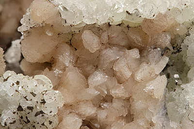
| Species: | K Feldspar var: Adularia |
| Formula: | KAlSi3O8 |
| Comments: | Found in basalt cavities usually on top of datolite or prehnite indicating late crystallization. |
| Habit: | "cauliflower-like" aggregates |
| Colour: | Peach to tan |
| Quality for species: | Good crystals or rich for species - important (!) |
| Abundance at site: | Rare |
| Confirmation |
|---|
|
| Validity: | Believed Valid |
| Associated Minerals Based on Photo Data: |
|---|
|
| Hematite | ⓘ9 photos of Adularia associated with Hematite at this locality. |
| Datolite | ⓘ7 photos of Adularia associated with Datolite at this locality. |
| Anhydrite | ⓘ4 photos of Adularia associated with Anhydrite at this locality. |
| Data |
|---|
|
| Mineral Data: | Click here to view Adularia data |
| Locality Data: | Click here to view State Route 9 - Ellis Street and State Route 72 interchanges (State Route 72 roadcut), New Britain, Hartford County, Connecticut, USA |
| Photo Gallery | View Gallery (4 photos) |
| Data Identifiers |
|---|
|
| Mindat Occurrence Record ID: | 922234 |
| Long-form Identifier: | 1:3:922234:2 |
| GUID (UUID V4): | 15f7c7de-2856-4edc-b1fe-b05e93da1e79 |
| Nearest other occurrences of Adularia |
|---|
|
|
| 0.5km (0.3 miles) | ⓘSherrill Street quarry, New Britain, Hartford County, Connecticut, USA |
| 8.3km (5.2 miles) | ⓘState Route 4 road cut, Farmington, Hartford County, Connecticut, USA |
| 16.4km (10.2 miles) | ⓘStrickland Quarry, Strickland pegmatite, Collins Hill, Portland, Middlesex County, Connecticut, USA |
| 17.1km (10.6 miles) | ⓘTaine Mountain, Burlington, Hartford County, Connecticut, USA |
| 22.5km (14.0 miles) | ⓘState Route 2 roadcut, Marlborough, Hartford County, Connecticut, USA |
| 24.4km (15.2 miles) | ⓘ"Foothold Cleft", Airline Railroad, East Hampton (Chatham), Middlesex County, Connecticut, USA |
| 30.6km (19.0 miles) | ⓘNorth Haven, New Haven County, Connecticut, USA |
| 30.8km (19.1 miles) | ⓘState Routes 8 and 118 interchange, Harwinton, Litchfield County, Connecticut, USA |
| 31.2km (19.4 miles) | ⓘHewitt Gem Quarry (Herb's Gem Quarry; Sawmill Quarry), Haddam, Middlesex County, Connecticut, USA |
| 31.8km (19.8 miles) | ⓘMesa Drive roadcuts, Bethany, New Haven County, Connecticut, USA |
| References |
|---|
|
|


State Route 9 - Ellis Street and State Route 72 interchanges, New Britain, Hartford County, Connecticut, USA