| Locality type: | Mine |
| Classification |
|---|
|
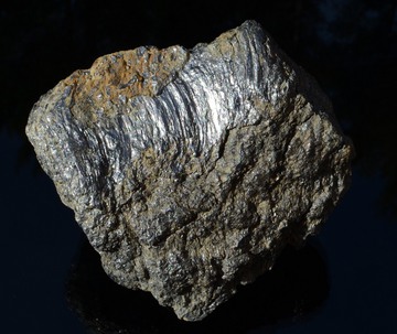
| Species: | Graphite |
| Formula: | C |
| Confirmation |
|---|
|
| Validity: | Believed Valid |
| Data |
|---|
|
| Mineral Data: | Click here to view Graphite data |
| Locality Data: | Click here to view Sturbridge Graphite Mine (Tantiusques Mine; Winthrop Lead Mine), Sturbridge, Worcester County, Massachusetts, USA |
| Photo Gallery | View Gallery (13 photos) |
| Data Identifiers |
|---|
|
| Mindat Occurrence Record ID: | 92641 |
| Long-form Identifier: | 1:3:92641:6 |
| GUID (UUID V4): | df6b3128-f7b9-47f9-a6f2-20ba3ee931fb |
| Nearest other occurrences of Graphite |
|---|
|
|
| 7.3km (4.5 miles) | ⓘCordierite locality (Bigelow Pond), Union, Tolland County, Connecticut, USA |
| 12.1km (7.5 miles) | ⓘLead Mine, Ashford, Windham County, Connecticut, USA |
| 39.7km (24.7 miles) | ⓘWorcester Coal Mine, Worcester, Worcester County, Massachusetts, USA |
| 48.5km (30.1 miles) | ⓘHebron, Tolland County, Connecticut, USA |
| 57.6km (35.8 miles) | ⓘConklin Quarry, Lime Rock, Lincoln, Providence County, Rhode Island, USA |
| 59.7km (37.1 miles) | ⓘDexter Quarry (Dexter Lime Quarry), Lime Rock, Lincoln, Providence County, Rhode Island, USA |
| 61.4km (38.1 miles) | ⓘBishop Hill Schorl Locality, East Hampton (Chatham), Middlesex County, Connecticut, USA |
| 61.5km (38.2 miles) | ⓘ"Foothold Cleft", Airline Railroad, East Hampton (Chatham), Middlesex County, Connecticut, USA |
| 62.9km (39.1 miles) | ⓘBolton Lime Quarries (Bolton Quarry; Whitcomb Quarry; Hildreth Quarry), Bolton, Worcester County, Massachusetts, USA |
| 64.1km (39.9 miles) | ⓘMasslite Quarry, Plainville, Norfolk County, Massachusetts, USA |
| References |
|---|
|
|


Sturbridge Graphite Mine, Sturbridge, Worcester County, Massachusetts, USA