Celtic Gold Mine, Ten Mile Outcamp, Leonora Shire, Western Australia, Australia

| Latitude & Longitude (WGS84): | 28° 20' 58'' South , 121° 9' 40'' East |
|---|---|
| Latitude & Longitude (decimal): | -28.34935,121.16124 |
| GeoHash: | G#: qdyntp4vj |
| Locality type: | Mine |
| Köppen climate type: | BWh : Hot deserts climate |
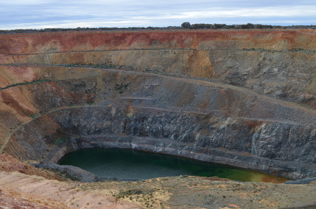
The Celtic Gold Mine is an abandoned open pit, 70 kilometres north of Leonora, bordering the west side of the Goldfields Highway. It was mined by Sons of Gwalia, with the Wonder West and Wonder North pits from 2000 to 2002. This period produced in total from the three pits of 1.7 Mt of ore at 2.15 g/t for 115 000 ounces of gold.
Bligh Resources came to own the mines due to its gradual takeover of SR Mining Pty Ltd. They named it the Bundarra Gold Project. Bligh estimates Celtic contains 1.25 MT of ore at 2.05 g/t yielding 83 000 ounces of gold.
The deposit is located at the contact with greenstone and granite/syenite on the west margin of a large granite batholith,adjacent to the Keith-Kilkenny Shear Zone. The host rock is dolerite with sills and dykes of magma, mingled syenite and granodiorite.
Commodity List
This is a list of exploitable or exploited mineral commodities recorded at this locality.Mineral List
1 valid mineral.
Rock Types Recorded
Select Rock List Type
Alphabetical List Tree DiagramRegional Geology
This geological map and associated information on rock units at or nearby to the coordinates given for this locality is based on relatively small scale geological maps provided by various national Geological Surveys. This does not necessarily represent the complete geology at this locality but it gives a background for the region in which it is found.
Click on geological units on the map for more information. Click here to view full-screen map on Macrostrat.org
| Quaternary 0 - 2.588 Ma ID: 917228 | colluvium 38491 Age: Pleistocene (0 - 2.588 Ma) Description: Colluvium and/or residual deposits, sheetwash, talus, scree; boulder, gravel, sand; may include minor alluvial or sand plain deposits, local calcrete and reworked laterite Comments: regolith; synthesis of multiple published descriptions Lithology: Regolith Reference: Raymond, O.L., Liu, S., Gallagher, R., Zhang, W., Highet, L.M. Surface Geology of Australia 1:1 million scale dataset 2012 edition. Commonwealth of Australia (Geoscience Australia). [5] |
| Neoarchean - Mesoarchean 2500 - 3200 Ma ID: 3189870 | Archean intrusive rocks Age: Archean (2500 - 3200 Ma) Comments: Yilgarn Craton Lithology: Intrusive igneous rocks Reference: Chorlton, L.B. Generalized geology of the world: bedrock domains and major faults in GIS format: a small-scale world geology map with an extended geological attribute database. doi: 10.4095/223767. Geological Survey of Canada, Open File 5529. [154] |
Data and map coding provided by Macrostrat.org, used under Creative Commons Attribution 4.0 License
References
External Links


Celtic Gold Mine, Ten Mile Outcamp, Leonora Shire, Western Australia, Australia