 | Mihajlović, Tamara, Lengauer, Christian L., Ntaflos, Theodoros, Kolitsch, Uwe, Tillmanns, Ekkehart (2004) Two new minerals, rondorfite, Ca8Mg[SiO4]4Cl2, and almarudite, K(□,Na)2(Mn,Fe,Mg)2(Be,Al)3 [Si12O30], and a study of iron-rich wadalite, Ca12[(Al8Si4Fe2)O32]Cl6, from the Bellerberg (Bellberg) volcano, Eifel, Germany. Neues Jahrbuch für Mineralogie - Abhandlungen, 179 (3) 265-294 doi:10.1127/0077-7757/2004/0179-0265 | Journal (article/letter/editorial) | | from the Bellerberg (Bellberg) volcano, Eifel, Germany Tamara Mihajlović, Christian L. Lengauer, Theodoros...from the Bellerberg (Bellberg) volcano, Eifel, Germany. – N. Jb. Miner. Abh. (179): 265 – 294; Stuttgart...from a quarry at the Bellerberg (Bellberg) volcano lava field (near Ettringen), 2 km north of Mayen, Eastern...Eastern Eifel volcanic area, Germany. Rondorfite, not uncommon in Ca-rich xenoliths at this locality, forms...in xenoliths from the Bellerberg volcano near Ettringen, located within the Quaternary volcano region |  | Lengauer, C. L., Hrauda, N., Kolitsch, U., Krickl, R., Tillmanns, E. (2009) Friedrichbeckeite, K (□0.5Na0.5)2 (Mg0.8Mn0.1Fe0.1)2 (Be0.6 Mg0.4)3 [Si12O30], a new milarite-type mineral from the Bellerberg volcano, Eifel area, Germany. Mineralogy and Petrology, 96 (3) 221-232 doi:10.1007/s00710-009-0050-9 | Journal (article/letter/editorial) | | mineral from the Bellerberg volcano, Eifel area, Germany C. L. Lengauer & N. Hrauda & U. Kolitsch & R. Krickl...from a quarry at the Bellerberg volcano near Ettringen, eastern Eifel volcanic area, Germany. It forms...from the Bellerberg volcano 222 SE of Ettringen, Germany, which is located within the region around...and kindly provided by Joachim Jahn, Neuwied, Germany. The mineral is named in honour of the Austrian...investigated material was found in the quarry of the firm ‘A. Caspar’ within the Bellerberg volcano (N 50° |  | | Journal (article/letter/editorial) | | Ettringer Bellerberg volcano, Eifel district, Germany (Hentschel, 1964). The mineral wadalite, Ca12Al10Si4O32[Cl6]...xenolith in tephrite, Bellerberg volcano, East Eifel, Germany (Galuskin et al., 2013); 13, ideal composition...xenolith in tephrite, Bellerberg volcano, East Eifel, Germany (author’s data); 11, 12, ideal compositions Ca12Al12FeSiO32[...tephrite, East Eifel, Germany. A, Caspar quarry; Bellerberg; B, Emmelberg quarry. Hem, hematite; Hrm,...to form Ca-silico-ferrites of the aenigmatite-rhönite-dorrite group (Scarlett et al., 2004). It should |  | | Book | | O8 , A New Mineral from the Bellerberg Volcano, Germany Reprinted from: Minerals 2018, 8, 308, doi:10.3390/min8070308...Zirconolite-Related Mineral from the Eifel Volcanic Region, Germany Reprinted from: Minerals 2018, 8, 449, doi:10.3390/min8100449...Volcano, South Ossetia and Bellerberg Volcano, Germany Reprinted from: Minerals 2018, 8, 399, doi:10.3390/min8090399...territories of each of these two countries. Italy and Germany (350 each) are next, followed by Canada (230),...were discovered in the Eifel region, Rhineland-Palatinate, Germany. Volcanic rocks of Eifel are a unique |  | | Journal (issue) | | eumberland. 2. + 4. calcit-Kristalle. Tafi's wen Quarry, Wales. Sammlung I. Jones. Fotos w. Waeger. Herausragend...Mineralien mit der Typlokalität Bellerberg (Stbr. Caspar), welches von der IMA unter der No. 2014-008 als...(Ti-haltig) oder als Dorrit (Ti-frei). Da einige Rhönite aus der Eifel, speziell die vom Nickenicher Sattel...Nomenklatur vorgeschlagen, nach der diese titanarmen Rhönite dem Dorrit zugeordnet werden sollten. Diese Ansicht...9) e.g. ,,rhönite" from Nickenicher Sattel (alternative name, Eicher Sattel), Eifel, Germany, (Kunzmann |
|

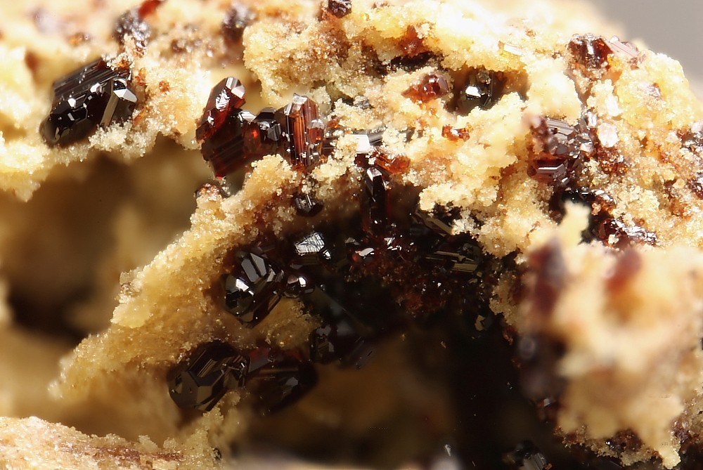


Caspar quarry, Ettringen, Vordereifel, Mayen-Koblenz, Rhineland-Palatinate, Germany