 | | Journal (article/letter/editorial) | | Mountains, centered on the Weardale area of northern England, have yielded enormous amounts of both lead and...partner in UK Mining Ventures,which is operating a specimen-recoveryproject at the Rogerley mine in Weardale...Weardale, England. His most recent article for Rocks & Minerals was titled “The Rogerley Mine, Weardale,... County Durham, England” and appeared in the January/February 2000 issue. 378 ROCKS & MINERALS Downloaded...cost of rehabilitating and running an underground mine, coupled with everincreasing environmental concerns |  | | Journal (article/letter/editorial) | | From the North Pennines Orefield England Figure 1. The Groverake mine, located in upper Rookhopeburn,...operating commercial fluorspar mine in the North Pennines, closing in 1999. Mine waste heaps (known locally...nineteenth centuries can be seen on the hills above the mine site. Figure 2 (left). A scattering of numerous... with calcite on quartz matrix, 14 × 10 × 7 cm, recovered from the Cambokeels mine in the early 1980s...× 4-cm specimen was recovered from the Rogerley mine in 2013. 306 ROCKS & MINERALS Figure 4. General |  | | Report (issue) | | ORE o, /J / \ I DEPOSITS UPPER WEARDALE, DURHAM ' I.JILES -:•••..... . ...___ •• • •:•• ...Structure of Ore-bodies lviineralo gy I. Weardale, Co. Durham 1. Carricks 11ine - 2. Rowantree A - 3. Rowantree...Rispey - 13. Mines on two Fell top Lir::estones in Rookhope (Frazers Hush, Groverake, Stotfield Head) 14....- 21. E. Dryburn - 22. Bollihope Teesdale, Co. Durham 1. Langdon - 2. Bands 5. Bow Lee - 6. Snaisgill... 1 • in Cumberland and Dun Fell Mine in Wes·tmorland. Co. Durham, is also a potential producer. Bol |  | | Journal (article/letter/editorial) | | University of Birmingham, Edgbaston, Birmingham, B15 2TT, UK B.YOUNG British Geological Survey, Windsor Court...Court, Windsor Terrace, Newcastle upon Tyne, NE2 4HB, UK AND C. J. STANLEY Department of Mineralogy, The...Cromwell Road, London, SW7 3BD, UK Abstract Bismuthinite-bearing quartz veins from the Alston Block of...Pennine Orefield are all close to, or above, the Rookhope and Tynehead cupolas of the buried Weardale Granite...of the orefield. Rhythmical crystallization of quartz, chalcopyrite and minor pyrite is followed by |  | | Journal (article/letter/editorial) | | Fluorite, Heights mine, North vein, near Eastgate, Weardale, County Durham, England. This transparent...Fluorite, Dow Scar level, Hilton mine, near Appleby, Scordale, Cumbria, England. This well-formed twinned yellow...conditions, Rosiclare level, Denton mine, Harris Creek district, Hardin County, Illinois. The specimen is 8...the Lead Hill area, Cave-in-Rock district, Hardin County, Illinois, and is 5.5 cm. Ross Lillie specimen...minerals include pyrite, marcasite, dolomite, calcite, quartz, and occasionally barite, fluorite, celestine, |  | | Book (edition) | | Stainmore The northern one-third of the Backbone of England, that ridge of hilly country known since last century...a cavity in the Great Limestone flats, Boltsburn Mine. Collected by Sir Arthur Russell and now in the...sheets 19 and 25, and parts of 13, 24, 26, 31, 32 (England and Wales) LONDON: HMSO 1990 . I\. © C,rown...sheets 19 and 25 and parts of 13, 24, 26, 31, 32 (England and Wales). Author Sir Kingsle_y Dunham, DSc, SD...FRS, FEng, FIMM Charleycroft, QuarryheadsLane) Durham DHJ 3D Y Other publications of the Survey dealing |  | | Report (edition) | | and Durham, and in smaller quantities elsewhere. It is commonly associated with calc-spar, quartz, and...association is· with calc-spar and barytes, though in Durham where much of the country-rock is arenaceous, the...the association is with calc-spar and quartz. The output has been for many years in excess of home requirements...being had to the more costly process of mining. In Durham the veins, which were left intact by the old miners...Carruthers has had charge of the Northumberland, Durham and • Yorkshire sections; Mr. R. W. Pocock has |  | | Book | | publishers. Beamish, The North of England Open Air Museum,County Durham [Beamish]: pages 41, 46, 54, 59(x2)...Earth Sciences,University of Durham: page_26 C H. Emeleus,University of Durham: page 26 Friends of Killhope...Valley ................... The Northumberland and Durham Coalfield ............. The Northern Pennine Orefield................... 201 72 Foreword ORTHERN England, an area of great natural beauty, is additionally...Pennines, Cumbria, various regions of north-east England, and North Yorkshire. Such a diverse expanse naturally |  | | Report (chapter) | | Grove carbonate hosted Pb/Zn fluorspar mine, north Pennines, UK K. L. Johnson and P. L. Younger Geological...Grove carbonate hosted Pb/Zn fluorspar mine, north Pennines, UK K. L. J O H N S O N & R L. Y O U N G E...University of Newcastle, NEI 7RU UK (e-mail: k.l.johnson @ncl.ac. uk) Abstract: The problems associated...associated with predicting where mine water will emerge and what the quality will be in a post-closure situation...closure of Frazer's Grove, a fluorspar mine in the North Pennines in the UK has given the opportunity to study |  | | Journal (issue) | | is that David, while at University, represented England in the sport of 'winks', which apparently was taken...impurities. Thus elsewhere in this Newsletter Groverake Mine is described as a commercial producer of fluorspar...au South Caradon 5551 The site of South Caradon mine at St. Cleer Cornwall, has been declared by English...moss. The accessible underground workings of the mine are leased by the Caradon Mines Research Group,...mainly the removal of iron stains, clay, calcite and quartz to either clean or uncover minerals that are considered |  | | Book (edition) | | MEMOIRS OF THE GEOLOGICAL SURVEY OF GREAT BRITAIN ENGLAND AND WALF�S GEOLOGY OF THE NORTHERN PENNINE OREFIELD...inserted on the six-inch maps, and all available mine-sections were reduced to the common scale of 200...made by him. The willing co-operation of all the mine-owners and operators and their staffs made possible... B. Laporte & Co., the Owners of Settlingstones Mine Ltd., Holmside ·& South Moor Colliery Co. Ltd.,...Plan of the North Central flats, Rotherhope Fell Mine 82 11. Cross-section of Burtrec Pasture Vein |  | | Report (issue) | | 0308-2199j BRITISH MINING No.5 MEMOIRS of NORTHERN MINE the RESEARCH 1977 SOCIETY NOTES FOR CONTRIBUTORS...exploration and geological research with reference to mine workings of the British Isles are welcome for inclusion...addressed to: R.H. Bird Esq. The Editor, Northern Mine Research Society, 41 Windsor Walk, South Anston...Guthrie Esq . Publication After Sales, Northern Mine Research Society, 186 Station Road, Billingham TS23...otherwise, without prior permission of the Northern Mine Research Society. Further, any opinions or statements |  | | Report (issue) | | given by the World Bureau of Metal Statistics, the UK Iron and Steel Statistics Bureau, the British Aggregate...agent in oil and gas well drilling fluids. Foss Mine, near Aberfeldy, Scotland operated by M-1 Great...Man) States Office, Guernsey Valuation Office Agency UK Iron and Steel Statistics Bureau Annual Statistics...are excluded from the production statistics. The UK part of the Continental Shelf is included in both...yard Cubic metre = 0.764555 1 1.19599 1 1.30795 UK gallon 1 0.2199755 =1 Litre = 4.54596 =1 Symbols: |  | | Report (issue) | | given by the World Bureau of Metal Statistics, the UK Iron and Steel Statistics Bureau, the British Aggregate...the continuous mining and quarrying record of the UK. Underpinning the Yearbook is a comprehensive data...Man) States Office, Guernsey Valuation Office Agency UK Iron and Steel Statistics Bureau Annual Statistics...are excluded from the production statistics. The UK part of the Continental Shelf is included in both...984206 Square yard 1 1.19599 Cubic yard 1 1.30795 UK gallon 1 0.2199755 =1 = 1.01605 =1 Square metre |  | | Journal (issue) | | on the occurrence of erythrite at East Blackcraig Mine, Newton Stewart, ............................ ....of the best apatites (amongst other things) in the UK. He also collected superb specimens on the Lizard...also spent some years working at the South Crofty mine as a surveyor and then as a geological Nick was...to members about such thing; as events, meeting;, mine closures, access issues, collections for sale, other...George Ryback, Journal Editor Insurance The first UK RIGS Conference The Society has renewed its Public |  | | Report (issue) | | given by the World Bureau of Metal Statistics, the UK Iron and Steel Statistics Bureau, the British Aggregate...Cover photograph Head frame of the Parys Mountain mine in Anglesey owned by Anglesey Mining plc. The 300...of Industry asle of Man) States Office, Guernsey UK Iron and Steel Statistics Bureau Annual Statistics...are excluded from the production statistics. The UK part of the Continental Shelf is included in both...Cubic yard 1 1.30795 Cubic metre = 0.764555 =1 UK gallon 1 0.2199755 Litre = 4.54596 =1 Symbols: |  | | Book (edition) | | Galleries, London ISBN O85272 313 X ClO Printed in the UK for the British Geological Survey by Saxon Graphics...sales of minerals produced in Britain, on an ex-mine or quarry basis, the total value is estimated at...and the major proportion of this output is from the UK Continental Shelf. However, there is a substantial...volume goes to press, the closure of the last tin mine in Britain was announced. In addition, through local...Directory. • Britain comprises Great Britain (England, Scotland and Wales) and Northern Ireland; its |  | | Journal (issue) | | analytical methods A total of 25 representative run-of-mine samples of uncut gem quality rubies, natural pale...from Chimwadzulu and some background information on mine production. The author is grateful to Ian Gill,...Rock-Forming Minerals. 2nd edn. Longman, Harlow, UK. pp.696 Emmett, J.L., 2000. An update on ruby and...Identification de I'origine naturelle ou artificielle des quartz. Revue de Gemmologie, 138/139, 74-84 Diamond grading...botryoidal or stalactitic agate, banded agate, quartz, etc, with no opal, 20% of the géodes contain common |  | | Report (issue) | | commentary on the UK minerals industry and that less emphasis should be placed on UK overseas trade, particularly...commentary on current trends and developments in the UK minerals industry is incorporated in the new publication...are excluded from the production statistics. The UK part of the Continental Shelf is included in both...Cubic yard 1 1.30795 Cubic metre = 0.764555 = 1 UK gallon 1 0.2199755 Litre = 4.54596 = 1 Symbols:...1983-1987 UK production of minerals 1983-1987 UK production of minerals by countries 1987 UK employment |  | | Report (volume) | | Mine Water Hydrogeology and Geochemistry Geological Society Special Publications Society Book Editors... GEOLOGICAL SOCIETY SPECIAL PUBLICATION No. 198 Mine Water Hydrogeology and Geochemistry EDITED BY P...University of Newcastle upon Tyne, UK and N.S. ROBINS British Geological Survey, UK 2002 Published by The Geological...is Registered Charity 210161. The Society is the UK national learned and professional society for geology...fifth of the Society's fellowship resides outside the UK. To find out more about the Society, log on to www |  | | Report (issue) | | given by the World Bureau of Metal Statistics, the UK Iron and Steel Statistics Bureau, the Quarry Products...Cover photograph Cooks Headframe, South Crofty tin mine, Cornwall. The man riding winder is to the right...had already been out of use for some time when the mine closed in March 1998 since for several years ore...(Guernsey) Valuation Office Agency Property Market Report UK Iron and Steel Statistics Bureau Annual Statistics...are excluded from the production statistics. The UK part of the Continental Shelf is included in both |
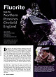
|


