 | | Journal (article/letter/editorial) | | BARBARA L. MUNTYAN 3500 S. Beryl Avenue Tucson, Arizona 85735 Downloaded by ["Queen's University Libraries... Figure 1 (left). View of Patagonia Mountains, Santa Cruz County, Arizona, in winter, from the approach...mine is located in the Patagonia mining district in Santa Cruz County, Arizona, on the northeast slopes...slopes of Mount Washington, about 2.5 miles southwest of Duquesne– Washington Camp. It is found at N¼NW¼...a drainage of San Antonio Canyon, located to the southeast and running toward the San Rafael Valley of |  | | Report (issue) | | No. 1 Arizona State Bureau of Mines Bulletin CHARLES F. WILLIS, Director Directory of Arizona Minerals...THE University of Arizona TUCSON, ARIZONA 1915-16 DIRECTORY (Compiled OF ARIZONA MINERALS from...ALABASTER (anhydrous gypsum.) Occurs in Superstition Mountains; near Pueblo Viego; near Sulphur Springs; in La...Tombstone district, Cochise County; Gila County, at Lost Gulch Mine, near Globe; Mohave County, in Mineral...Pima County, in Mammouth Mine, Schulty; Yavapai County, in ores of Bradshaw Mountains; Yuma County, in |  | | Report (issue) | | THE OCCURRENCE OF CINNABAR IN CENTRAL WESTERN ARIZONA. By ROWLAND BANCROFT. During the spring of 1909...reconnaissance of the economic geology of central western Arizona, examining, among other deposits, the well-known*...Quartzite. Because of the scarcity of this mineral in Arizona and the lack of any scientific literature on these...publish a brief preliminary description of this district. Development work has not been very extensive...Plomosa mining district, Yuma County, Ariz., in the southern part of the Dome Rock Mountains, some 8 |  | | Report (issue) | | Preliminary report of molybdenum occurrences in Arizona by Jan C. Wilt 1/, Stanley B. Keith 2/, Jocelyn...to the Arizona Bureau of Geology and Mineral Technology a division of The University of Arizona This...'1030571 04 M030562 04 M030563 04 '1030584 04 CouNTY DEPosir 'ostHP +litire LAtiroOE ♦ Looroae 28N... wA A 7 PROSPECT 15N 02E 27 MU AMOLE DISTRICT BANNER DISTRICT BLUE HELL GROUP 19N 215W 101 35-03-A wA...115W 118 34-56-154 113-54-53W CATALINA DISTRICT CATALINA DISTRICT CHILDS-ALOWINKLE HUN CINNABAR MINE 02N |  | | Report (volume) | | AND SAMUEL SANFORD A revision of Bulletin 585 WASHINGTON GOVERNMENT FEINTING OFFICE 1917 CONTENTS............................................ 10 Arizona......................................................................................... 102 District of Columbia ................................................................................ Washington................................................to refer to Geological Survey Bulletin 507, "The mining districts of the western United States," and to |  | | Book (volume) | | ...........................................13 Arizona ..........................................................................................506 Washington ..............................................................548 Table of Maps Page Alabama County Map ...................................................................................4 Alaska County and Stream Map ...................................................................14 Arizona – Apache Co. Mining Districts .......................... |  | | Book (volume) | | ...........................................11 Arizona ..........................................................................................411 Washington ...............................................rights, so remember you were told. If in doubt, a county map will tell you who the legal owner is. Good...gemmy qualities for cutting and polishing. AUTAUGA COUNTY PRATTVILLE, N. 6 mi., and just E of the Birmingham...were well known to prehistoric Indians.) BARBOUR COUNTY BAKER HILL, SE 1 mi. : 1 in a deep ravine, as a |  | | Book (volume) | | ...........................................11 Arizona ..........................................................................................413 Washington ...............................................rights, so remember you were told. If in doubt, a county map will tell you who the legal owner is. Good...gemmy qualities for cutting and polishing. AUTAUGA COUNTY PRATTVILLE, N. 6 mi., and just E of the Birmingham...were well known to prehistoric Indians.) BARBOUR COUNTY BAKER HILL, SE 1 mi. : 1 in a deep ravine, as a |  | | Report (volume) | | DEPOSITS A SHORT REVIEW BY a FRANK L. HESS WASHINGTON GOVERNMENT FEINTING OFFICE 1924 7/3 ADDITIONAL...SUPERINTENDENT OF DOCUMENTS GOVERNMENT PRINTING OFFICE WASHINGTON, D. C. AT 15 CENTS PER COPY CONTENTS Page..._______ New Mexico __________________________ Arizona _ __________________________ Other localities _____...PLATE I. Molybdenite from quartz veins: A, From Railroad Creek near Lake Chelan, Okanogan County, Wash.;...and sericitized quartz porphyry (?) carrying molybdenite along veinlets, Climax, Colo______ _________ |  | | Report (volume) | | COMPILED BY SAMUEL SANFORD AND RALPH W. STONE WASHINGTON GOVERNMENT PRINTING OFFICE 1914 USEFUL MINERALS...it helpful to refer to Survey Bulletin 507, "The mining districts of the western United States," and to...abundant, it may have been completely exhausted by mining or quarrying. Deposits of minerals of wide distribution...because they occur in sufficient quantity to warrant mining for their usual products but because they furnish... Tenn. California........Mr. William H. Storms, San Francisco. Prof. A. F. Rogers, Stanford University |  | | Report (issue) | | Mineralogist OIAF GEOLOGIC BFL^NCH Ferry Building, San Francisco San Francisco P. JENKINS Chief Geologist ...°\ x *T U L A R E I s_ i»KCBSFltLO •Z R f SAN, BERNARDINO \ SSANTA BARBARA j^^'»-f"''*\L0SAN6tLCS...1 D E J •LEGEND- MEXICO -^ Mining O Division Boundaries. Mining Division Offices. (6) PREFACE...a part of the Fourth Annual Report of the State Mining Bureau, by Henry G. Hanks, who was then State Mineralogist...''Minerals of California," of the California State Mining Bureau. In the thirty years which had elapsed since |  | | Book | | stumble over a valuable nugget and stake your own mining claim? Indeed it to is, and author book Jay...prospecting, he points out, is in abandoned mining districts, where valuable mineral ores are present...commercial ores and secondary minerals by state, county, township, and geologic range. For easy identification...Ransom AMERICA THE ROCK-HUNTER'S RANGE GUIDE ARIZONA GEM TRAILS PETRIFIED FOREST TRAILS A Range Guide...RANSOM 1875-1948 An to the Eastern '‘Schoolmarm” Mining Camps of the Old West I I a s I \ h K |  | | Report (issue) | | Empire. No attempt has been made to give details of mining or metallurgical processes. HARCOURT, Chairman..."ore-bearing zone" 1'ead "ore-bearing zone of the Knaben district," and transpose the paragraph with that following...particular were then willing to pay large sums for molybdenite concentrate, and in America the consumption largely...any practical importance, namely molybdenite and wulfenite. Molybdenite : Molybdenum sulphide (MoS2) ,...iron molybdate, produced by altera tion of molybdenite in the presence of iron compounds. This mineral |  | | Report (issue) | | said to have been found in the mining the nugget Jim, Placer County, California, in 1871 by a small...and Geology mineral exhibit in in the Cali- San Francisco MINERALS OF CALIFORNIA CENTENNIAL VOLUME...and ROBERT WALLACE WEBB University of CcdifomicL Santa Barbara With sections by Ian Campbell and Eleanor...BULLETIN California Division of Ferry Building, San 189 Mines and Geology Francisco, 1966 CA 94111...Counties of California: Minerals and mineral lists Mining Districts of California Unvalidated entries in | 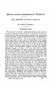 | | Report (issue) | | operations have been described in the early days of mica mining by white people, and several of the deposits where...are described below. The present period of mica mining was begun in 1867 by L. E. Persons, of Philadelphia...Mr. Persons's attention was directed to Jackson County by someone in Philadelphia who had seen a crystal...In the fall of 1867 Mr. Persons went to Jackson County and learned from Mr. Davies the location of favorable...belt lies in the Piedmont Plateau and its small mountains, southeast of the Blue Ridge. Mica mines have |  | | Book (volume) | | Fourche and Cheyenne rivers. These pine covered mountains, higher than the Alleghenies, culminate in Harney...beds, excavations, etc.Selenite roses. BRULE COUNTY AREA: in the Oacoma zone of the Pierre Fm. On Elm...gray Barite rosette up to 5 or 6 inches. CAMPBELL COUNTY MOUND CITY, W to the Missouri R., regional hillsides...gravels, etc.petrified wood, wood opal. CORSON COUNTY LITTLE EAGLE: area ridges, slopes, stream beds...Guide for Rock Hounds in the United States CUSTER COUNTY AREA: The November Mine, 1.2 mi. SE of the Needles |  | | Report (issue) | | ;wIFORNIA STATE Mii^ix^v BtmiiAU FERRY BUILDING - SAN FRANOSCC im^ ibiiiiiiliiii .III— Bb^aa^Aai^^...FERRY BUILDIN(;. MININC; BUREAU SAN FRANCISCO FLETCHER HAMILTON San Francisco] State Mineralogi8l ...particular service in co- operating with the State ^Mining Bureau in making possible this addition to our...a part of the Fourth Annual Report of the State Mining Bureau, by Henry G. Hanks, who was then quently...the thirty years which elapsed since the State Mining Bureau. appearance of the second list, our knowledge |  | | Book | | P. Blake, professor of mineralogy, geology and mining at the College of California, parent to the University...California, and published in the fourth and sixth State Mining Bureau reports. Then beginning in 1914 with a volume...mainly in the Sierra Nevada and the Klarnath Mountains provinces. These mountain regions , together with...are reported by county of occurrence. Map 1-2 shows the county boundaries and county names. When possible...Meridian (M.D.M. Mount Diablo Meridian;S.B.M. - San Bernardino Meridian; and H.M. - Humboldt Meridian) | | | Book | | ^ '“ P r . . . I West Orange SOUTH SAN FRANCISCO PUBLIC LIBRARY 9048 00992838 7 257989 R q549...P. Blake, professor of mineralogy, geology and mining the at College of California, parent to the...mineralogist of California, and pub- and sixth State Mining Bureau reports. Then beginning volume prepared...have been found mainly in Nevada and the Klamath Mountains provinces. These mountain regions, together with...species are reported by 1-2 shows the county boundaries and county names. When possible, locations of mines |  | | Report (issue) | | DIVISION Director OF MINES FERRY BUILDING, SAN FRANCISCO OLAF San Francisco P. 11 JENKINS, Chief BULLETIN... and ROBERT W. WEBB University of California, Santa Barbara College Goleta, California Price $3.00...Robert W. Webb of the University of California, Santa Barbara College, as part of a continuing- cooperative...rewhich was publi.shed as Bulletin 67 of the State Mining Bureau. vision by the same author in 192-3 increased...specimens in the exhibit of the Division of Mines at San Francisco carry the letters S.M.B., and the specimen |  | | Journal (volume) | | NATURAL RESOURCES DIVISION OF MINES FERRY BUILDING, SAN FRANCISCO WALTER Vol. 39 W. BRADLEY State Mineralogist...REPORT XXXIX STATE DIVISION OF MINES FERRY BUILDING, SAN FRANCISCO CALIFORNIA 21200 LIBRARY UNIVERSITY OF...Mineralogist Olaf San Francisco P. Jenkins, Chief Geologist C. A. Logan, District Mining Engineer C. ...Laizure, District W. Burling Tucker, Reid J. J. C. District Mining Engineer District Mining Engineer...Engineer Mining Engineer O'Brien, District Mining Engineer George John District Sampson, Assistant |  | | Book | | Rock-Hunter's Range Guide Petrified Forest Trails Arizona Gem Trails and the Colorado Desert of California...HARPER & ROW, PUBLISHERS ....... New York, Evanston, San Francisco, London 1817 Portions of this book have...Hunting; Hunting for Radioactive Minerals; Clothing and Camp Equipment 5. The Rock Collector's Working Tools...Minerals in L.\merica Alabama Alaska Arkansas Arizona California Colorado Connecticut Delaware Florida...Dakota Tennessee Texas Utah Vermont Virginia Washington West Virginia Wisconsin Wyoming Appendixes 615 |  | | Book | | 139) Page 248: Quartz (amethyst variety), Erongo Mountains, Namibia * 5 x 6 x 3 cm Page 251: Calcite, Irai...Serbia ¢ 11x8x7cm LEFT: Fluorite, Taihang Shan Mountains, Hebei, China * 19x13x1cm 10 | MINERALS: PRODUCTS...be minerals. Microcline, Crystal Peak, Colorado, USA * 12 x 9x 5 cm. Biominerals Crystals formed by biological...extended periods of stability PLANET | 114 San Carlos district, Chihuahua, Mexico * 8 x 4 x 2 om are uncommon...zeolites. Calcite (septarian nodule), San Juan County, Utah, USA » 18 x 24 x 8 om 14 MINERALS: PRODUCTS |  | | Book (volume) | | jasp-agate and common opal, rivaling in beauty the Arizona agatized wood. This gem flint occurs in the 8 mile...ASHTABULA COUNTY CONNEAUT, area pits, quarries, rd. cuts, etc.⎯cone-in-cone Calcite. CLERMONT COUNTY MILFORD...CLINTON COUNTY WILMINGTON, area of Todd’s Ford, a mineral deposit⎯Hematite. COSHOCTON COUNTY AREA, townships...townships of Washington, Virginia, Bedford, Jackson, Jefferson, Bethlehem, Monroe and Clark; on regional...CUYAHOGA COUNTY CHAGRIN FALLS (on Geauga Co. line), area quarries⎯oilstone. DELAWARE COUNTY DELAWARE |  | | Book (volume) | | jasp-agate and common opal, rivaling in beauty the Arizona agatized wood. This gem flint occurs in the 8 mile...ASHTABULA COUNTY CONNEAUT, area pits, quarries, rd. cuts, etc.⎯cone-in-cone Calcite. CLERMONT COUNTY MILFORD...CLINTON COUNTY WILMINGTON, area of Todd’s Ford, a mineral deposit⎯Hematite. COSHOCTON COUNTY AREA, townships...townships of Washington, Virginia, Bedford, Jackson, Jefferson, Bethlehem, Monroe and Clark; on regional...CUYAHOGA COUNTY CHAGRIN FALLS (on Geauga Co. line), area quarries⎯oilstone. DELAWARE COUNTY DELAWARE |
|


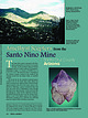
Santo Nino Mine, Santo Niño Mine area, San Antonio Canyon, Duquesne-Washington Camp, Patagonia Mining District, Patagonia Mountains, Santa Cruz County, Arizona, USA