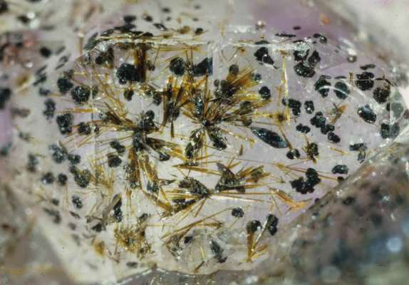
 | | Journal (volume) | | on some Microminerals from the Ohio pit, Baraga County, Michigan Al Falster 920 McIntosh Wausau, Wl 54401...54401 I I r i The Ohio pit in Baraga County, Michigan, is an old open-pit iron mine. In vugs and cavities...commonly forms rosettes of shiny black crystals. Hematite also occurs as replacing agent of magnetite (martite)...responding to the magnet are evidently replaced by hematite (see above). Goethite appears as delicate sprays...inclusions in clear or smoky quartz. Goethite (and hematite) are the major components of the a NEWSLETTER |  | | Report (volume) | | Geology of the , Dry Mountain Quadrangle , Jefferson County, Montana By HAROLD J. PROSTKA -/ , CONTRIBUTIONS...igneous rocks along the east margin of the Boulder batholith UNITED STATES GOVERNMENT PRINTING OFFICE...____________________________________________ Rocks of the Boulder batholith________________________________ Small...GEOLOGY OF THE DRY MOUNTAIN QUADRANGLE, JEFFERSON COUNTY, MONTANA By HAROLD J. PROSTKA ABSTRACT This report...quadrangle, an area along the east margin of the Boulder batholith southeast of Butte, Mont. The oldest rock's |  | | Report (volume) | | 574 MINING DISTRICTS OF THE DILLON QUADRANGLE, MONTANA AND ADJACENT AREAS BY ALEXANDER N. WINCHELL ................. 75 Outlying mines in Beaverhead County.................................. 76 Polaris district...................:.................... 146 Dry Boulder Creek......................................................... 168 Elkhorn district (Beaverhead County).................................. 168 Location...Valley with Ruby Range in the distance, Madison County, Mont.; B, Dredge No. 2, of stacker type, Ruby |  | | Report (issue) | | Range mineral belt of Colorado; the Boulder batholith area, Montana ; the Sierra Ancha region, Arizona...including Arizona, California, Colorado~ Idaho, Montana, Nevada, New Mexico, and FRANK W. OsTERWALD ...was known to occur in the Leyden Coal mine~ Jefferson County, Colo., as early as 1875 (Berthoud, 1875,...called the mineral coracite because he thought Routt County, Colo. (Gale, 1908); and deposits at San that although...(Sprigg, 1954, p. 8) extracted from an unGilpin County, Colo., in 1871 by Ric}lard Pearce known tonnage |  | | Report (volume) | | Daybreak mines, Washington; the W. Wilson mine, Montana; the White King mine, Oregon; the deposits in the...GEOLOGY area, Montana and Wyoming, and the deposits in the Dripping Spring quartzite, Gila County, Ariz. According...Beryllium deposits of the Mount Antero region, Chaffee County, Colorado: U. S. Geol. Survey Bull. 982-D, p. 95-119...Golden Gate Canyon and Ralston Creek areas, Jefferson County, Colorado: U. S. Geol. Survey Circ. 320,16...at nine localities in the northern part of Jefferson County, Colo., in shear zones that cut Precambrian |  | | Report (issue) | | Resources of the Elkhorn Wilderness Study Area, Montana A cooperative study by the U.S. Geological Survey... __ -- . __««.»____.____ ,_«.___._ .~.__ -« Jefferson City zone Base- and precious metal-bearing quartz...Elkhorn wilderness study area, Jefferson and Broadwater Counties, Montana Aeromagnetic anomaly map for...Resources of the Elkhorn Wilderness Study Area, Montana Chapter A Mineral Resource Assessment by William...forest land in the Elkhorn Wilderness Study Area, Montana that is being considered for wilderness designation |  | | Report (issue) | | Bear Trap Canyon Instant Study Area, Madison County, Montana By Darrell M. Pinckney, William F. Hanna,...S. Geological Survey sample sites, Madison County, Montana............ In pocket 2. Regional gravity...gravity and magnetic anomaly maps, Montana....... In pocket 3. Composite high-level aeromagnetic anomaly...Canyon Instant Study Area and adjacent areas, Montana..................................................Canyon Instant Study Area and adjacent areas, Montana... 5. In pocket In pocket Map showing locations |  | | Journal (article/letter/editorial) | | ABSTRACTS OF PAPERS SUBMITTED TO THE MEETING IN BUTTE, MONTANA MAY 8, 1953 ROCKY MOUNTAIN SECTION (GSA) LOUIS...South Dakota, in the vicinity of the Harney Peak batholith. Mapping shows that the pegmatite is concordant...GOLDEN GATE CANYON AND RALSTON CREEK AREAS, JEFFERSON COUNTY, COLORADO John W. Adams U. S. Geological Survey...at eight localities in the northern part of Jefferson County, Colorado, in shear zones that cut Precambrian...CRETACEOUS-EARLY TERTIARY SEDIMENTS IN EASTERN MONTANA Kirk Badgley, Jr. Geology Department, University |  | | Journal (article/letter/editorial) | | OF VEINS BATHOLITH, PART BARRIE H. BIELER IN URANIUM-BEARING THE BOULDER MONTANA: II--THE VEINS..."siliceous reef" uraniferous veins of the Boulder batholith con- tain, in decreasingorderof abundance...SomeHydrothermalVein Deposits in the Boulder Batholith, Montana," The PennsylvaniaState University, 1955...red brown. Red coloration, as might be causedby hematite,is rare. The pigmentationis commonlydistribut..."siliceousreef" uranium-bearingveins of the Boulder batholith are characterized by a gangueof quartz that |  | | Report (issue) | | PRELIMINARY REPORT ON THE COMET AREA JEFFERSON COUNTY MONTANA UNITED STATES DEPARTMENT OF THE INTERIOR...PRELIMINARY REPORT ON THE COMET AREA JEFFERSON COUNTY, MONTANA By George E. Becraft This report concerns... PRELIMINARY REPORT ON THE COMET AREA JEFFERSON COUNTY, MONTANA By George E. Becraft CONTENTS Page Page............ Hope-Bullion ...................... Boulder Chief mine................. Younger deposits.....Free Enterprise mine............... High Ore (Montana Consolidated) mine.. Literature cited ........ |  | | Journal (article/letter/editorial) | | Montana Mineral Locality Index Downloaded by [University of Nebraska, Lincoln] at 20:00 09 April 2015...2015 K NOWN AS THE TREASURE STATE, Montana is rich in mineral and gemstone localities. The state motto...The middle third of the state is known as the Montana alkali province where the sediments have MICHAEL...Indian Queen mine ca. 1905 at Farlin, Beaverhead County. 208 ROCKS & MINERALS Downloaded by [University...mines at Butte in Silver Bow County and the Black Pine mine in Granite County have produced many fine crystal |  | | Report (volume) | | of the Basin Quadrangle Jefferson, Lewis and Clark, and Powell Counties, Montana By EDWARD T. RUPPEL GEOLOGICAL...report of an area along the west margin of the Boulder batholith UNITED STATES GOVERNMENT PRINTING OFFICE...the Basin quadrangle, Jefferson, Leis and Clark, and Powell Counties, Montana. Washington, U.S. Govt...119-121. 1. Geology Montana Basin quadrangle. 2. Mines and mineral resources Montana Basin quadrangle.... I. Title: Basin quadrangle. Montana. (Series) For sale by the Superintendent of Documents, U.S. Government |  | | Report (volume) | | Thorium Deposits in East-Central Idaho Southwestern Montana GEOLOGICAL SURVEY BULLETIN 988-H Uranium...Thorium Deposits in East-Central Idaho Southwestern Montana By ALBERT F. TRITES, JR., and EDWIN W. TOOKER ...claim____________________________ Pegmatite on Montana State land.______________ Gray Goose claims___...______________ Lemhi Pass district, Idaho and Montana._______________ Wonder Lode mine_-____________...sections of the Trapper no. 1 claim, Beaverhead County, Mont__________________________ In pocket FIQTJEE |  | | Report (issue) | | the Southern Elkhorn Mountains Jefferson and Broadwater Counties, Montana By M. R. KLEPPER, R. A. WEEKS...Maywood and Red Lion formations Devonian system Jefferson dolomite Devonian and Mississippian systems Three...porphyry Turnley Ridge stock Rocks of the Boulder batholith Quartz monzonite, granodiorite, and related...younger intrusive rocks Faults younger than the batholith Faults of uncertain origin Tectonic history Geomorphology...quadrangle, Montana. 2. Geologic map and sections, north half of Devils Fence quadrangle, Montana. 3. Geologic |  | | Report (volume) | | Uranium-Bearing Deposits West of Clancey Jefferson County Montana GEOLOGICAL SURVEY BULLETIN <> 8 8 -... Uranium-Bearing Deposits West of Clancey Jefferson County Montana By WAYNE A. ROBERTS and ARTHUR J. GUDE...containing uraniferous deposits west of Clancey, Jefferson County, Mont..._----_____-__.___ In pocket 19. Geologic...Index map showing area mapped near Clancey, Jefferson County.__--___-_-.-.-___.___.._......._._.... 70...URANIUM-BEARING DEPOSITS WEST OF CLANCEY, JEFFERSON COUNTY, MONTANA By WAYNE A. ROBERTS and AKTHUR J. GTJDE |  | | Report (issue) | | Deposits of the Jefferson City QuadranglJefferson and Lewis and Clark Counties, Montana By GEORGE E....1922Geology and mineral deposits of the Jefferson City quadrangl~, ·Jefferson and Lewis and Clark Counties, Montarra...deposits of the Jefferson City quadrangle, J e:fferson and Lewis and Cl ark Counties, Montana. 1963. (Card...2) 1 1. 'Geology-Montana-.Jefferson City quadrangle. 2. Ore-depositsMontana-Jefferson C:ity quadrangle...quadrangle. 3. Mines and mineral resources-Montana-Jefferson City quadrangle. I. Pinckney, Darrell Mayne, 1925- |  | | Report (volume) | | Broadwater and jefferson Counties, Montana U.S. GEOLOGICAL SURVEY BULLETIN 1805 MONTANA Mineral Resources...Wilderness Study Area, Broadwater and Jefferson Counties, Montana By WILLIAM R. GREENWOOD, STEVE LUDINGTON...Wilderness Study Area, Broadwater and Jefferson Counties, Montana. (Studies related to wilderness) (U.S...no.: I 19.3:1805 1. Mines and mineral resources-Montana-Elkhorn Wilderness. 2. Elkhorn Wilderness (Mont...forest land in the Elkhorn Wilderness Study Area, Montana, that is being considered for wilderness designation |  | | Report (issue) | | ASSESSMENT OF THE HELENA NATIONAL FOREST, WEST-CENTRAL MONTANA Edited by R.G. Tysdal 1 , Steve Ludington2 , and...ASSESSMENT OF THE HELENA NATIONAL FOREST, WEST-CENTRAL MONTANA U.S. GEOLOGICAL SURVEY OPEN-FILE REPORT 96-683-A...in west-central Montana. It lies in the vicinity of Helena, the capitol city of Montana, and includes Federal...lands within parts of five counties: Broadwater, Jefferson, Meagher, Powell, and Lewis and Clark. * Gold...Gold was discovered in the region in Powell County in 1852. Mining began in the 1860's, and since then the |  | | Report (volume) | | Sunlight Gold-Silver Breccia Pipe, Southwestern Montana U.S. GEOLOGICAL SURVEY BULLETIN 2155 AVAILABILITY...Sunlight Gold-Silver Breccia Pipe, Southwestern Montana By Ed DeWitt, Eugene E. Foord, Robert E. Zartman...Sunlight gold-silver breccia pipe, southwestern Montana I by Ed DeWitt ... [et al.]. p. cm.-(U.S. Geological...Igneous-Montana. 3. Hydrothermal alteration-Montana. 4. Gold ores-Montana. 5. Breccia pipes-Montana. I. DeWitt......... ... .. .. Location map of southwestern Montana showing localities and rock units discussed in |  | | Journal (article/letter/editorial) | | ALTERATION BOULDER POSSIBLE OF SOME BATHOLITH, SIGNIFICANCE APLITE-PEGMATITES MONTANA, TO ORE ............................. ABSTRACT The Boulder batholith containsmany texturally complexleucogranitic...are commonin someaplite-pegmatiteintrusives near Boulder, Mont. These internal alterationsare small, irregular...physical-chemicalconditionsof crystallizationin the batholith. Becausehydrothermal alterations in the quartz...causethe observedhydrothermalalterationsof the batholith and may also transport ore-metals. These fluids |  | | Report (volume) | | Bulletin 842 OF THE GREATER HELENA MINING REGION MONTANA BY J. T. PARDEE and F. C. SCHRADER UNITED STATES...than the Boulder batholith._____________________ Quartz monzonite and aplite of the Boulder batholith_______...___________________________________ Rocks younger than the Boulder batholith.__________________ Ore deposits._________................_....._.............._ Basin and Boulder districts____.--_________-_------_-__---_-_Elkhorn... Page PLATE 1. 2. 3. 4. 5. Area of the Boulder batholith and traces of overthrust faults. In |  | | Report (issue) | | Northern Elkhorn Mountains I I Jefferson and Broadwater Counties, Montana GEOLOGICAt ' SURVEY PROFESSIONAL...Northern Ell(horn Mountains Jefferson. and Broadwater CountieS, Montana By HARRY w. SMEDES GEOLOGICAL...Tertiary System ______________________ _ Boulder batholith ______________________________ _ Early mafic...________ _ Structures related to emplacement of the batholith __ _ Postbatholith structures ________________________...THE NORTHERN ELKHORN MOUNTAINS JEFFERSON AND BROADWATER COUNTIES, MONTANA BY HARRY ABSTRACT The northern |  | | Report (chapter) | | Geology, Indiana University, Bloomington, I N 47405, USA Abstract: A survey of detrital opaque Fe-Ti oxide...Rocky Mountains, USA (semi-arid climate, high relief) and the Appalachian Mountains, USA (humid climate...within a dissected magmatic arc in southwestern Montana, USA. A separate discriminant function is calculated...principally consist of magnetite, ilmenite and hematite either as monomineralic grains or as polymineralic...provenance of the Tertiary Renova sandstones of Montana, USA on the basis of their D O P Q characteristics |  | | Journal (article/letter/editorial) | | Mineralogy and Petrology of a Tactite near Helena, Montana* by ROBERT J. SHEDLOCKt AND ERIC J. ESSENE The...plutonites of the Boulder Batholith near its north-east margin twelve miles east of Helena, Montana. First described...of 3-4 km of stratigraphic cover for the Boulder Batholith indicates pressures of approximately 1 kb...phase of the Boulder Batholith along its north-east margin in Jefferson County, Montana (Sections 22...Ranch Complex, the early mafic intrusives of the batholith, completely enclose the septa which have been |  | | Report (volume) | | Utah, the northern Rocky Mountains of Idaho and Montana, and the Cascade Range of Washington. The intrusives...from the northern Rocky Mountains of Idaho and Montana, and low strontium in those from the Cascade Range...-T-T^CASCADE I *21 RANGE I ^WASHINGTON I "~"^ \ V MONTANA \ ( v vx:H*:' NORTHERN /to .,:.-.-:S?;*:-- ::...quartz inonzonite f acies of the White Creek batholith in British Columbia were reported by Rimsaite...of biotites from plutons in the Sierra Nevada batholith of California in relation to changes in physical |
|


Delmoe Lake area, Boulder Batholith, Jefferson County, Montana, USA