| Locality type: | Prospect |
| Classification |
|---|
|
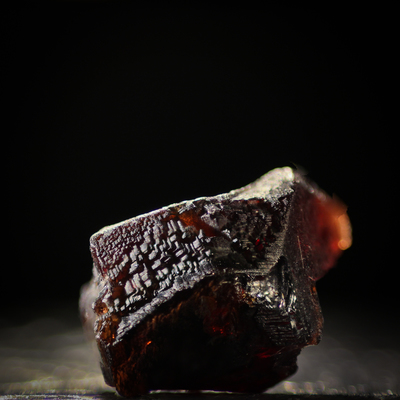
| Species: | Almandine |
| Formula: | Fe32+Al2(SiO4)3 |
| Confirmation |
|---|
|
| Validity: | Believed Valid |
| Associated Minerals Based on Photo Data: |
|---|
|
| Tourmaline | ⓘ4 photos of Almandine associated with Tourmaline at this locality. |
| Garnet Group | ⓘ1 photo of Almandine associated with Garnet Group at this locality. |
| Data |
|---|
|
| Mineral Data: | Click here to view Almandine data |
| Locality Data: | Click here to view Sly Rick prospect (Green Centipede claim), Little Cahuilla Mountain, Cahuilla Mining District, Riverside County, California, USA |
| Photo Gallery | View Gallery (4 photos) |
| Data Identifiers |
|---|
|
| Mindat Occurrence Record ID: | 386213 |
| Long-form Identifier: | 1:3:386213:1 |
| GUID (UUID V4): | 7026b4ca-b004-4356-8fe9-ceae0a756340 |
| Nearest other occurrences of Almandine |
|---|
|
|
| 0.9km (0.5 miles) | ⓘAudrey Lynn Mine (Audrey Lynne Mine; Jumping Joe claims), Little Cahuilla Mountain, Cahuilla Mining District, Riverside County, California, USA |
| 3.1km (1.9 miles) | ⓘJuan Diego Mine No. 1 (Juan Diego No. 1 deposit; Rainbow Mine; Rainbow prospects), Little Cahuilla Mountain, Cahuilla Mining District, Riverside County, California, USA |
| 5.9km (3.7 miles) | ⓘAnita Mine (Magee Mine; Magee & Dougherty Mine; Sage Mine), Red Mountain, Cahuilla Mining District, Riverside County, California, USA |
| 7.1km (4.4 miles) | ⓘWilliamson Mine (Coahuila Brave claim; Williamson Silica Mine), Cahuilla Mountain, Cahuilla Mining District, Riverside County, California, USA |
| 7.1km (4.4 miles) | ⓘLithia Dike Mine (Lithia Dyke claim), Cahuilla Mountain, Cahuilla Mining District, Riverside County, California, USA |
| 33.8km (21.0 miles) | ⓘCarmelita Mine (Big Spring mine; Blue Gem claim; Crest Gem mine; Elinor deposit; Elinor mine; Estudillo mine; French Pete mine; MS 6130; Peter Cabat mine), Chihuahua Valley, Warner Springs Mining District, San Diego County, California, USA |
| 34.5km (21.4 miles) | ⓘSouthern Pacific Silica Quarry (Southern Pacific deposit; Nuevo Mine; Southern Pacific Quarry; S.P. Silica Quarry; S.P. Mine; Nuevo Quarry), Nuevo, Lakeview Mountains, Riverside County, California, USA |
| 34.9km (21.7 miles) | ⓘSempe Mine (Sempa mine; Senpa mine; Senpe mine), Hiriart Mountain (Hariat Mtn; Harriot Mtn; Heriart Mtn; Heriot Mtn; Hiriat Hill), Pala, Pala Mining District, San Diego County, California, USA |
| 34.9km (21.7 miles) | ⓘLower Salmons View prospect, Chief Mountain, Pala, Pala Mining District, San Diego County, California, USA |
| 34.9km (21.7 miles) | ⓘUpper Salmons View prospect, Pala Chief Mine (Chief mine; MS 6452; Salmons mine), Chief Mountain, Pala, Pala Mining District, San Diego County, California, USA |
| References |
|---|
|
|


Sly Rick prospect, Little Cahuilla Mountain, Cahuilla Mining District, Riverside County, California, USA